The Climate of
Argentina
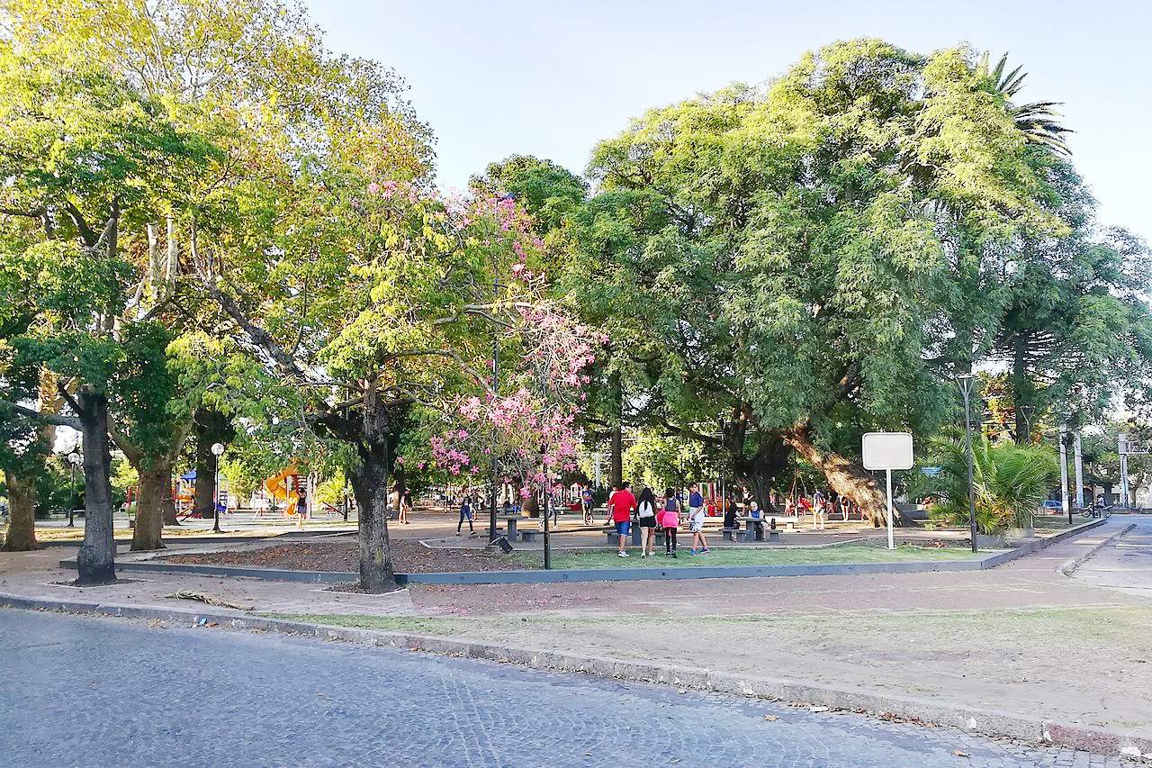 Plaza Alsina in La Plata
Climate Map
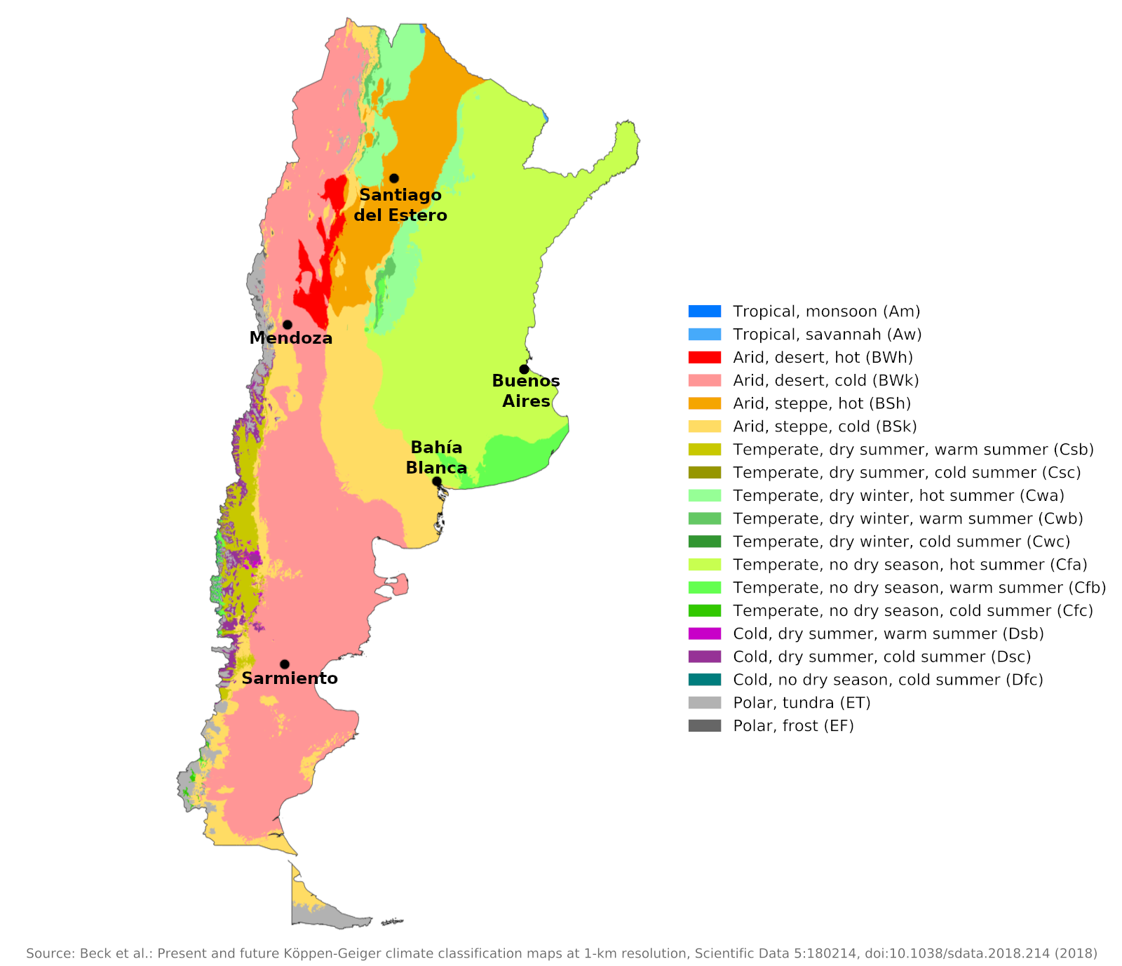 Climate map of Argentina
What is the climate of Argentina like?
Argentina is a large country with an area about one-third the size of the United States and almost as large as India. It occupies the southern portion of South America, east of the crest-line of the Andes, which form its border with Chile. On the north it is bordered by Bolivia and Paraguay and on the east by Brazil and Uruguay. From the mouth of the River Plate to the southern tip of Tierra del Fuego, its coast is on the Atlantic Ocean.
Argentina's large expanse and its elevation range from sea level westward to the permanently snow-capped peaks of the Andes give it a very varied climate, further modified by the mountain barriers. The effect of the southern Andes is to create a sharp contrast between the very cloudy and humid climate of southern Chile and the arid, almost desert-like conditions of southern Argentina's Patagonia, sheltered from the sustained westerly winds that blow at these latitudes. Argentina can be divided into four major climatic regions: east-central Argentina or the Pampas, north-east interior, west Argentina and Patagonia or south Argentina, to which should be added the characteristic mountain climate of the high Andes.
East Central Argentina or the Pampas
This area has a similar climate to Uruguay. It lies well outside the tropics and has a reasonable rainfall of between 500 and 1,250 millimeters (20–50 inches) per year. Winters are mild and summers are warm, with more rainfall in the summer months. The rain falls on a few days, so wet, changeable weather is not very common and it often rains heavily. Annual rainfall decreases west and south, illustrated by Buenos Aires and Bahía Blanc in the southern Pampas.
| Climate data for Buenos Aires (1981–2010) | |||||||||||||
|---|---|---|---|---|---|---|---|---|---|---|---|---|---|
| Month | Jan | Feb | Mar | Apr | May | Jun | Jul | Aug | Sep | Oct | Nov | Dec | Year |
| Average high °C (°F) | 30.1 (86.2) | 28.7 (83.7) | 26.8 (80.2) | 22.9 (73.2) | 19.3 (66.7) | 16.0 (60.8) | 15.3 (59.5) | 17.7 (63.9) | 19.3 (66.7) | 22.7 (72.9) | 25.6 (78.1) | 28.5 (83.3) | 22.7 (72.9) |
| Daily mean °C (°F) | 24.9 (76.8) | 23.6 (74.5) | 21.9 (71.4) | 17.9 (64.2) | 14.6 (58.3) | 11.6 (52.9) | 11.0 (51.8) | 12.8 (55.0) | 14.6 (58.3) | 17.9 (64.2) | 20.6 (69.1) | 23.3 (73.9) | 17.9 (64.2) |
| Average low °C (°F) | 20.1 (68.2) | 19.2 (66.6) | 17.7 (63.9) | 13.8 (56.8) | 10.7 (51.3) | 8.1 (46.6) | 7.4 (45.3) | 8.8 (47.8) | 10.3 (50.5) | 13.3 (55.9) | 15.9 (60.6) | 18.4 (65.1) | 13.6 (56.5) |
| Average precipitation mm (inches) | 138.8 (5.46) | 127.1 (5.00) | 140.1 (5.52) | 119.0 (4.69) | 92.3 (3.63) | 58.8 (2.31) | 60.6 (2.39) | 64.2 (2.53) | 72.0 (2.83) | 127.2 (5.01) | 117.3 (4.62) | 118.9 (4.68) | 1,236.3 (48.67) |
| Source: Servicio Meteorológico Nacional | |||||||||||||
The weather here is moderately sunny with an average of four to five hours of sunshine per day in winter and eight to nine hours in summer. The region does not often experience extreme heat or cold. Frost can occur during most winter months, but is not long-lasting or severe. The climate is generally pleasant. This is the country's most important agricultural region and occasional drought is the greatest economic threat.
In the north and pampas, the north wind is usually hot while the south wind is cold. The north wind usually ends with a thunderstorm or with a pampero, a cold south-west wind from the Andes that causes a drop in temperature and is most common from June to November—winter and spring. During summers in the Buenos Aires region, Pampero storms are a welcome phenomenon, marking the end of long periods of high humidity and heat
| Climate data for Bahía Blanca (1981–2010) | |||||||||||||
|---|---|---|---|---|---|---|---|---|---|---|---|---|---|
| Month | Jan | Feb | Mar | Apr | May | Jun | Jul | Aug | Sep | Oct | Nov | Dec | Year |
| Average high °C (°F) | 31.1 (88.0) | 29.6 (85.3) | 26.6 (79.9) | 21.8 (71.2) | 17.5 (63.5) | 14.1 (57.4) | 13.7 (56.7) | 16.3 (61.3) | 18.5 (65.3) | 22.2 (72.0) | 25.9 (78.6) | 29.3 (84.7) | 22.2 (72.0) |
| Daily mean °C (°F) | 23.6 (74.5) | 22.1 (71.8) | 19.4 (66.9) | 14.9 (58.8) | 11.1 (52.0) | 8.1 (46.6) | 7.5 (45.5) | 9.4 (48.9) | 11.6 (52.9) | 15.1 (59.2) | 18.7 (65.7) | 22.0 (71.6) | 15.3 (59.5) |
| Average low °C (°F) | 16.3 (61.3) | 15.2 (59.4) | 13.4 (56.1) | 9.2 (48.6) | 6.0 (42.8) | 3.3 (37.9) | 2.4 (36.3) | 3.9 (39.0) | 5.6 (42.1) | 8.5 (47.3) | 11.4 (52.5) | 14.4 (57.9) | 9.1 (48.4) |
| Average precipitation mm (inches) | 67.1 (2.64) | 67.1 (2.64) | 75.2 (2.96) | 54.5 (2.15) | 41.2 (1.62) | 31.5 (1.24) | 31.1 (1.22) | 34.5 (1.36) | 51.6 (2.03) | 73.3 (2.89) | 56.8 (2.24) | 67.3 (2.65) | 651.2 (25.64) |
| Source: Servicio Meteorológico Nacional | |||||||||||||
The Northern Interior
This region has a warmer climate than the Pampas and a tropical or near-tropical climate northward, where it includes part of the Chaco region described for Paraguay. Precipitation decreases towards the west and the city of Santiago del Estero is representative of the drier western part. Temperatures remain fairly high throughout the year. The combination of heat and humidity can sometimes be uncomfortable during the summer months as this is the cloudier, wetter season. Most of the time, however, conditions will be sunny and dry. Occasional cold spells in winter can bring temperatures near or below freezing for a few hours, but winters are generally mild or even warm.
| Climate data for Santiago del Estero (1981–2010) | |||||||||||||
|---|---|---|---|---|---|---|---|---|---|---|---|---|---|
| Month | Jan | Feb | Mar | Apr | May | Jun | Jul | Aug | Sep | Oct | Nov | Dec | Year |
| Average high °C (°F) | 33.9 (93.0) | 32.5 (90.5) | 30.4 (86.7) | 26.3 (79.3) | 23.1 (73.6) | 20.1 (68.2) | 20.9 (69.6) | 24.4 (75.9) | 26.9 (80.4) | 30.7 (87.3) | 32.2 (90.0) | 33.7 (92.7) | 27.9 (82.2) |
| Daily mean °C (°F) | 26.7 (80.1) | 25.5 (77.9) | 23.8 (74.8) | 19.8 (67.6) | 16.1 (61.0) | 12.7 (54.9) | 12.2 (54.0) | 15.3 (59.5) | 18.5 (65.3) | 22.7 (72.9) | 24.8 (76.6) | 26.5 (79.7) | 20.4 (68.7) |
| Average low °C (°F) | 20.5 (68.9) | 19.7 (67.5) | 18.5 (65.3) | 14.6 (58.3) | 10.4 (50.7) | 6.8 (44.2) | 5.0 (41.0) | 7.3 (45.1) | 10.3 (50.5) | 15.3 (59.5) | 17.8 (64.0) | 20.0 (68.0) | 13.9 (57.0) |
| Average precipitation mm (inches) | 134.8 (5.31) | 100.6 (3.96) | 91.1 (3.59) | 35.9 (1.41) | 17.2 (0.68) | 6.6 (0.26) | 3.0 (0.12) | 2.0 (0.08) | 12.3 (0.48) | 44.7 (1.76) | 66.7 (2.63) | 114.2 (4.50) | 629.1 (24.77) |
| Source: Servicio Meteorológico Nacional | |||||||||||||
Western Argentina
Western Argentina, including the northern Andes, is an arid region. Snow is scarce even on the higher mountains and the dryness is comparable to that of northern Chile on the west side of the Andes. The eastern slopes and foothills of the Andes down to 35 degrees south latitude are a semi-arid region, and the lowlands are practically desert. In many places, annual precipitation is less than 250 millimeters (10 inches) and is very unreliable. Droughts in this area are frequent and often prolonged. It rains more frequently in the summer months, which are generally hot and very sunny. Sunshine hours average up to ten hours a day in summer and between seven and eight hours in winter. The city of Mendoza is representative of this region.
| Climate data for Mendoza (1981–2010) | |||||||||||||
|---|---|---|---|---|---|---|---|---|---|---|---|---|---|
| Month | Jan | Feb | Mar | Apr | May | Jun | Jul | Aug | Sep | Oct | Nov | Dec | Year |
| Average high °C (°F) | 30.4 (86.7) | 29.1 (84.4) | 26.5 (79.7) | 22.0 (71.6) | 17.9 (64.2) | 15.0 (59.0) | 14.5 (58.1) | 17.3 (63.1) | 19.9 (67.8) | 24.2 (75.6) | 27.3 (81.1) | 29.8 (85.6) | 22.8 (73.0) |
| Daily mean °C (°F) | 23.9 (75.0) | 22.5 (72.5) | 20.0 (68.0) | 15.3 (59.5) | 11.2 (52.2) | 8.1 (46.6) | 7.5 (45.5) | 10.0 (50.0) | 13.0 (55.4) | 17.5 (63.5) | 20.6 (69.1) | 23.2 (73.8) | 16.1 (61.0) |
| Average low °C (°F) | 18.2 (64.8) | 16.9 (62.4) | 15.1 (59.2) | 10.8 (51.4) | 7.0 (44.6) | 3.9 (39.0) | 3.1 (37.6) | 5.1 (41.2) | 7.4 (45.3) | 11.5 (52.7) | 14.5 (58.1) | 17.3 (63.1) | 10.9 (51.6) |
| Average precipitation mm (inches) | 40.0 (1.57) | 43.0 (1.69) | 38.7 (1.52) | 19.6 (0.77) | 12.9 (0.51) | 8.7 (0.34) | 10.9 (0.43) | 10.4 (0.41) | 18.8 (0.74) | 13.7 (0.54) | 20.7 (0.81) | 28.0 (1.10) | 265.4 (10.45) |
| Source: Servicio Meteorológico Nacional | |||||||||||||
Patagonia or Southern Argentina
The southern third of Argentina, south of Bahía Blanca, is a rather dry region compared to the very humid region of southern Chile on the other side of the Andes. In terms of temperature and changeable weather, the region has a typical cool temperate but very dry climate. The prevailing winds in this southern region are west winds.
The table for Sarmiento is representative of the coast and much of the interior. To the west, in the foothills of the Andes, rainfall is heavier as clouds spill over from the west side of the range. The dryness of the east side continues in the cooler southern districts around the Strait of Magellan. The summers are extremely cool. Winters are long with frequent frosts and snow, but due to the influence of the ocean, the cold is never very severe or prolonged.
| Climate data for Sarmiento (1993–2013) | |||||||||||||
|---|---|---|---|---|---|---|---|---|---|---|---|---|---|
| Month | Jan | Feb | Mar | Apr | May | Jun | Jul | Aug | Sep | Oct | Nov | Dec | Year |
| Mean maximum °C (°F) | 32.4 (90.3) | 32.6 (90.7) | 29.4 (84.9) | 24.5 (76.1) | 19.8 (67.6) | 14.6 (58.3) | 15.0 (59.0) | 16.5 (61.7) | 20.7 (69.3) | 24.8 (76.6) | 28.1 (82.6) | 30.9 (87.6) | 34.7 (94.5) |
| Daily mean °C (°F) | 18.9 (66.0) | 18.1 (64.6) | 15.1 (59.2) | 11.4 (52.5) | 7.5 (45.5) | 4.1 (39.4) | 3.7 (38.7) | 5.7 (42.3) | 8.8 (47.8) | 12.3 (54.1) | 14.8 (58.6) | 17.7 (63.9) | 11.5 (52.7) |
| Mean minimum °C (°F) | 6.7 (44.1) | 5.5 (41.9) | 2.8 (37.0) | −0.2 (31.6) | −4.8 (23.4) | −6.3 (20.7) | −8.2 (17.2) | −5.3 (22.5) | −2.9 (26.8) | 0.7 (33.3) | 3.4 (38.1) | 5.6 (42.1) | −9.3 (15.3) |
| Average precipitation mm (inches) | 6.6 (0.26) | 10.6 (0.42) | 15.2 (0.60) | 11.8 (0.46) | 24.9 (0.98) | 23.0 (0.91) | 14.4 (0.57) | 16.4 (0.65) | 13.9 (0.55) | 11.0 (0.43) | 10.4 (0.41) | 5.5 (0.22) | 163.7 (6.44) |
| Source: Ministerio del Interior, Obras Públicas y Vivienda | |||||||||||||
References
- E. A. Pearce, Charles Gordon Smith, (1990) The Hutchinson World Weather Guide, John Murray Press. ISBN 1859863426
- Timothy L. Gall, (ed.), (2003), Worldmark Encyclopedia of the Nations, Eleventh Edition, Thomson Gale
- Hugh Chisholm, (ed.), (1911), Encyclopædia Britannica, Eleventh edition, Cambridge University Press
The Climate of
Argentina
In summary:
Argentina’s climate ranges from subtropical in the north, to humid in the central regions, to subantarctic in the south. Winter is the driest period of the year. The coldest months are June and July; the warmest month is January. Climate variations are due to the country’s range of altitude as well as of latitude.
Average rainfall declines from east to west. Buenos Aires receives an average of 1,200 mm (48 in) of rain annually and experiences light snow during the winter months. Areas north of Río Negro experience little precipitation during winter. The Pampas receives enough rainfall to support its crops, but it is also subject to flooding. The northeastern region bordering Brazil and Uruguay also receives sufficient rainfall. The Gran Chaco region north of the Pampas receives an average of 650 mm (25 in) of rainfall per year. The Andes region is subject to intense changes in weather, including flash floods during the summer months.