The Climate of the
Dominican Republic
.jpg) West facade of Catedral Santa María La Menor
West facade of Catedral Santa María La Menor
.jpg&oldid=616774705)
Climate Map
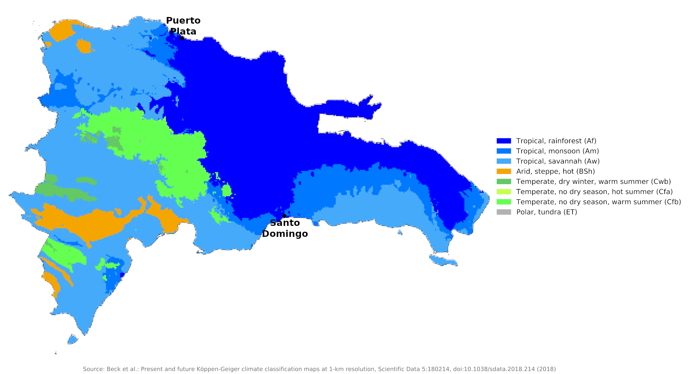 Climate map of the Dominican Republic
What is the climate of the Dominican Republic like?
The Dominican Republic occupies the eastern two-thirds of the large Caribbean island of Hispaniola and has a land border with Haiti on the west. The country has an area twice as large as the state of Vermont or Wales. It is the most mountainous of the Caribbean Islands, with the highest peaks rising over 3,000 meters (10,000 feet), but there are also considerable areas of lowland.
The Dominican Republic has a primarily tropical climate tempered by the prevailing easterly winds. Climate and rainfall vary with region and altitude. Generally, however, average minimum and maximum temperatures range from 18° to 29°C (64° to 84°F) in the winter and from 23° to 35°C (73° to 95°F) in the summer. Temperatures are highest along the coast and much cooler in the mountains. The coastal plain has an annual mean temperature of 26°C (79°F), while in the Central Cordillera the climate is temperate and the mean is 20°C (68°F). Highs of 40°C (104°F) are common in protected valleys, as are lows of 0°C (32°F) in mountainous areas. In general, August is the hottest month and January and February, the coolest.
In general, rainfall determines the seasons. Along the northern coast, the rainy season lasts from November through January (see the climate of Puerto Plata). In the rest of the country, it runs from May through November. The dry season lasts from November through April, with March being the driest month. The climate of Santo Domingo is representative of the south coast. Here the rainy season generally extends from May to November and the dry season from December to April.
Rainfall varies from an annual average of 1,300 millimeters (50 inches) in the eastern regions, with an extreme of 2,000 millimeters (80 inches) in the northeast, to an average of 430 millimeters (17 inches) in the western areas. The north coast gets more rain in the winter season, and less in the summer (see Puerto Plata). In general, the western part of the country, including the interior valleys, receives the least rain.
Tropical cyclones—such as tropical depressions, tropical storms, and hurricanes—occur on the average once every two years in the Dominican Republic. Around two-thirds of the storms strike the southern part of the country. Hurricane season lasts from the beginning of June to the end of November, but most hurricanes usually occur from August through October. The worst hurricanes arrive once every few years and can cause great damage.
| Climate data for Santo Domingo (1971-2000) | |||||||||||||
|---|---|---|---|---|---|---|---|---|---|---|---|---|---|
| Month | Jan | Feb | Mar | Apr | May | Jun | Jul | Aug | Sep | Oct | Nov | Dec | Year |
| Average high °C (°F) | 29.4 (84.9) | 29.3 (84.7) | 29.6 (85.3) | 30.3 (86.5) | 30.6 (87.1) | 31.3 (88.3) | 31.7 (89.1) | 31.8 (89.2) | 31.6 (88.9) | 31.3 (88.3) | 30.8 (87.4) | 29.8 (85.6) | 30.6 (87.1) |
| Daily mean °C (°F) | 24.7 (76.5) | 24.6 (76.3) | 25.1 (77.2) | 25.8 (78.4) | 26.5 (79.7) | 27.2 (81.0) | 27.3 (81.1) | 27.4 (81.3) | 27.3 (81.1) | 26.9 (80.4) | 26.3 (79.3) | 25.2 (77.4) | 26.2 (79.2) |
| Average low °C (°F) | 20.0 (68.0) | 19.9 (67.8) | 20.5 (68.9) | 21.4 (70.5) | 22.5 (72.5) | 23.1 (73.6) | 23.0 (73.4) | 23.0 (73.4) | 23.0 (73.4) | 22.6 (72.7) | 21.9 (71.4) | 20.6 (69.1) | 21.8 (71.2) |
| Average precipitation mm (inches) | 74.5 (2.93) | 67.9 (2.67) | 61.9 (2.44) | 72.1 (2.84) | 176.6 (6.95) | 116.4 (4.58) | 131.2 (5.17) | 178.1 (7.01) | 208.7 (8.22) | 186.2 (7.33) | 132.5 (5.22) | 82.9 (3.26) | 1,489 (58.62) |
| Source: Oficina Nacional de Meteorología | |||||||||||||
| Climate data for Puerto Plata (1970-2000) | |||||||||||||
|---|---|---|---|---|---|---|---|---|---|---|---|---|---|
| Month | Jan | Feb | Mar | Apr | May | Jun | Jul | Aug | Sep | Oct | Nov | Dec | Year |
| Average high °C (°F) | 28.9 (84.0) | 29.6 (85.3) | 29.4 (84.9) | 29.3 (84.7) | 31.2 (88.2) | 32.3 (90.1) | 32.6 (90.7) | 32.6 (90.7) | 32.7 (90.9) | 32.3 (90.1) | 30.6 (87.1) | 29.1 (84.4) | 30.9 (87.6) |
| Daily mean °C (°F) | 23.2 (73.8) | 23.1 (73.6) | 23.6 (74.5) | 24.6 (76.3) | 25.6 (78.1) | 26.3 (79.3) | 26.9 (80.4) | 26.8 (80.2) | 26.7 (80.1) | 26.2 (79.2) | 24.9 (76.8) | 23.6 (74.5) | 25.1 (77.2) |
| Average low °C (°F) | 17.5 (63.5) | 17.3 (63.1) | 17.8 (64.0) | 19.9 (67.8) | 20.0 (68.0) | 20.3 (68.5) | 21.1 (70.0) | 20.9 (69.6) | 20.7 (69.3) | 20.1 (68.2) | 19.1 (66.4) | 18.1 (64.6) | 19.4 (66.9) |
| Average precipitation mm (inches) | 175.3 (6.90) | 140.0 (5.51) | 128.7 (5.07) | 115.1 (4.53) | 129.0 (5.08) | 51.0 (2.01) | 69.8 (2.75) | 66.7 (2.63) | 63.7 (2.51) | 111.0 (4.37) | 228.5 (9.00) | 231.8 (9.13) | 1,510.6 (59.49) |
| Source: Oficina Nacional de Meteorología | |||||||||||||
References
- E. A. Pearce, Charles Gordon Smith, (1990) The Hutchinson World Weather Guide, John Murray Press. ISBN 1859863426
- Timothy L. Gall, (ed.), (2003), Worldmark Encyclopedia of the Nations, Eleventh Edition, Thomson Gale
- Federal Research Division, Library of Congress, (2001), Dominican Republic and Haiti: country studies. Claitor's Pub. Division. ISBN 0844410446
- Hugh Chisholm, (ed.), (1911), Encyclopædia Britannica, Eleventh edition, Cambridge University Press
The Climate of the
Dominican Republic
In summary:
The Dominican Republic has a semitropical climate tempered by the prevailing easterly winds. Temperatures range from 18° to 29°C (64° to 84°F) in the winter and from 23° to 35°C (73° to 95°F) in the summer. Temperatures are highest along the coast and much cooler in the mountains.
Annual rainfall averages about 1500 mm (60 in), but varies greatly by region, from 430 mm (17 in) in the arid west to 1350 mm (53 in) in the east. The northern mountains have an average rainfall of about 2000 mm (80 inches). Tropical hurricanes occur every few years.