The Climate of
Equatorial Guinea
 Immigrant memorial (1778) in Luba, Bioko
Climate Map
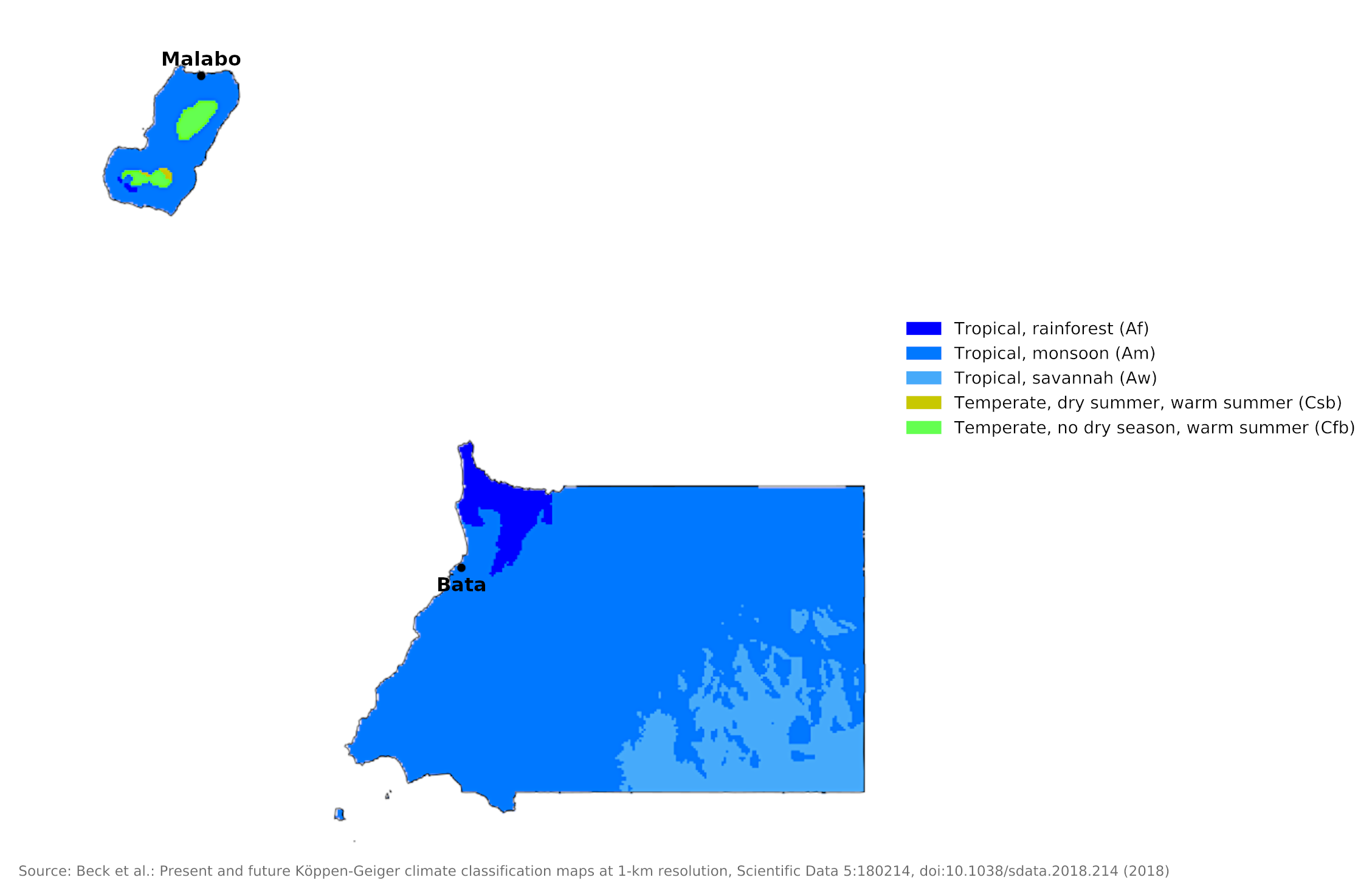
 Climate map of Equatorial Guinea
What is the climate of Equatorial Guinea like?
Equatorial Guinea is about the size of Wales or Israel. It lies on the coast of the Gulf of Guinea between Cameroon to the north and Gabon to the south. The country includes the offshore island of Bioko, which is mountainous and therefore particularly wet, and a number of smaller islands.
Both the mainland and the islands have a typical equatorial climate with high temperatures, high humidity, heavy rainfall, and much cloud around the year. The average temperature is about 25°C (77°F).
There are distinct wet and dry seasons. From June to August, the mainland, called Río Muni, is dry, whereas the main island of Bioko is wet; from December to February, the reverse obtains. Annual rainfall varies from 1,900 millimeters (75 inches) at Malabo to over 10,000 millimeters (400 inches) at San Antonio de Ureca on the south coast of Bioko Island. The country often experiences windstorms and flash floods.
| Climate data for Malabo (Bioko Island) | |||||||||||||
|---|---|---|---|---|---|---|---|---|---|---|---|---|---|
| Month | Jan | Feb | Mar | Apr | May | Jun | Jul | Aug | Sep | Oct | Nov | Dec | Year |
| Average high °C (°F) | 31.1 (88.0) | 31.8 (89.2) | 31.3 (88.3) | 31.3 (88.3) | 30.5 (86.9) | 29.5 (85.1) | 28.4 (83.1) | 28.0 (82.4) | 28.1 (82.6) | 28.8 (83.8) | 29.8 (85.6) | 30.8 (87.4) | 30.0 (86.0) |
| Daily mean °C (°F) | 26.9 (80.4) | 27.7 (81.9) | 27.6 (81.7) | 27.2 (81.0) | 26.7 (80.1) | 25.9 (78.6) | 25.3 (77.5) | 25.0 (77.0) | 25.1 (77.2) | 25.5 (77.9) | 26.1 (79.0) | 26.6 (79.9) | 26.3 (79.3) |
| Average low °C (°F) | 23.0 (73.4) | 23.9 (75.0) | 24.1 (75.4) | 23.8 (74.8) | 23.5 (74.3) | 23.3 (73.9) | 23.2 (73.8) | 23.1 (73.6) | 22.8 (73.0) | 22.9 (73.2) | 23.0 (73.4) | 22.7 (72.9) | 23.3 (73.9) |
| Average precipitation mm (inches) | 28.9 (1.14) | 70.6 (2.78) | 102.7 (4.04) | 155.7 (6.13) | 227.1 (8.94) | 260.8 (10.27) | 202.0 (7.95) | 177.1 (6.97) | 250.1 (9.85) | 254.3 (10.01) | 100.3 (3.95) | 39.6 (1.56) | 1,869.1 (73.59) |
| Source: Deutscher Wetterdienst | |||||||||||||
| Climate data for Bata (Río Muni) | |||||||||||||
|---|---|---|---|---|---|---|---|---|---|---|---|---|---|
| Month | Jan | Feb | Mar | Apr | May | Jun | Jul | Aug | Sep | Oct | Nov | Dec | Year |
| Average high °C (°F) | 30.5 (86.9) | 31.1 (88.0) | 31.3 (88.3) | 31.0 (87.8) | 30.7 (87.3) | 29.7 (85.5) | 28.8 (83.8) | 28.9 (84.0) | 29.1 (84.4) | 29.1 (84.4) | 29.6 (85.3) | 30.1 (86.2) | 30.0 (86.0) |
| Daily mean °C (°F) | 25.6 (78.1) | 25.8 (78.4) | 25.7 (78.3) | 25.6 (78.1) | 25.6 (78.1) | 25.0 (77.0) | 24.1 (75.4) | 24.2 (75.6) | 24.6 (76.3) | 24.8 (76.6) | 25.2 (77.4) | 25.0 (77.0) | 25.1 (77.2) |
| Average low °C (°F) | 20.7 (69.3) | 20.4 (68.7) | 20.1 (68.2) | 20.1 (68.2) | 20.6 (69.1) | 20.2 (68.4) | 19.4 (66.9) | 19.6 (67.3) | 20.0 (68.0) | 20.5 (68.9) | 20.8 (69.4) | 20.0 (68.0) | 20.2 (68.4) |
| Average precipitation mm (inches) | 116 (4.6) | 102 (4.0) | 205 (8.1) | 292 (11.5) | 285 (11.2) | 90 (3.5) | 25 (1.0) | 26 (1.0) | 221 (8.7) | 457 (18.0) | 306 (12.0) | 109 (4.3) | 2,234 (87.9) |
| Source: Deutscher Wetterdienst | |||||||||||||
References
- E. A. Pearce, Charles Gordon Smith, (1990) The Hutchinson World Weather Guide, John Murray Press. ISBN 1859863426
- Timothy L. Gall, (ed.), (2003), Worldmark Encyclopedia of the Nations, Eleventh Edition, Thomson Gale
- Hugh Chisholm, (ed.), (1911), Encyclopædia Britannica, Eleventh edition, Cambridge University Press
The Climate of
Equatorial Guinea

In summary:
As a result of its location near the equator, Equatorial Guinea has a warm, tropical climate with high temperatures, high humidity, and heavy rainfall.
There are distinct wet and dry seasons. From June to August, the mainland, called Río Muni, is dry, whereas the island of Bioko is wet; from December to February, the reverse obtains.