The Climate of
Italy
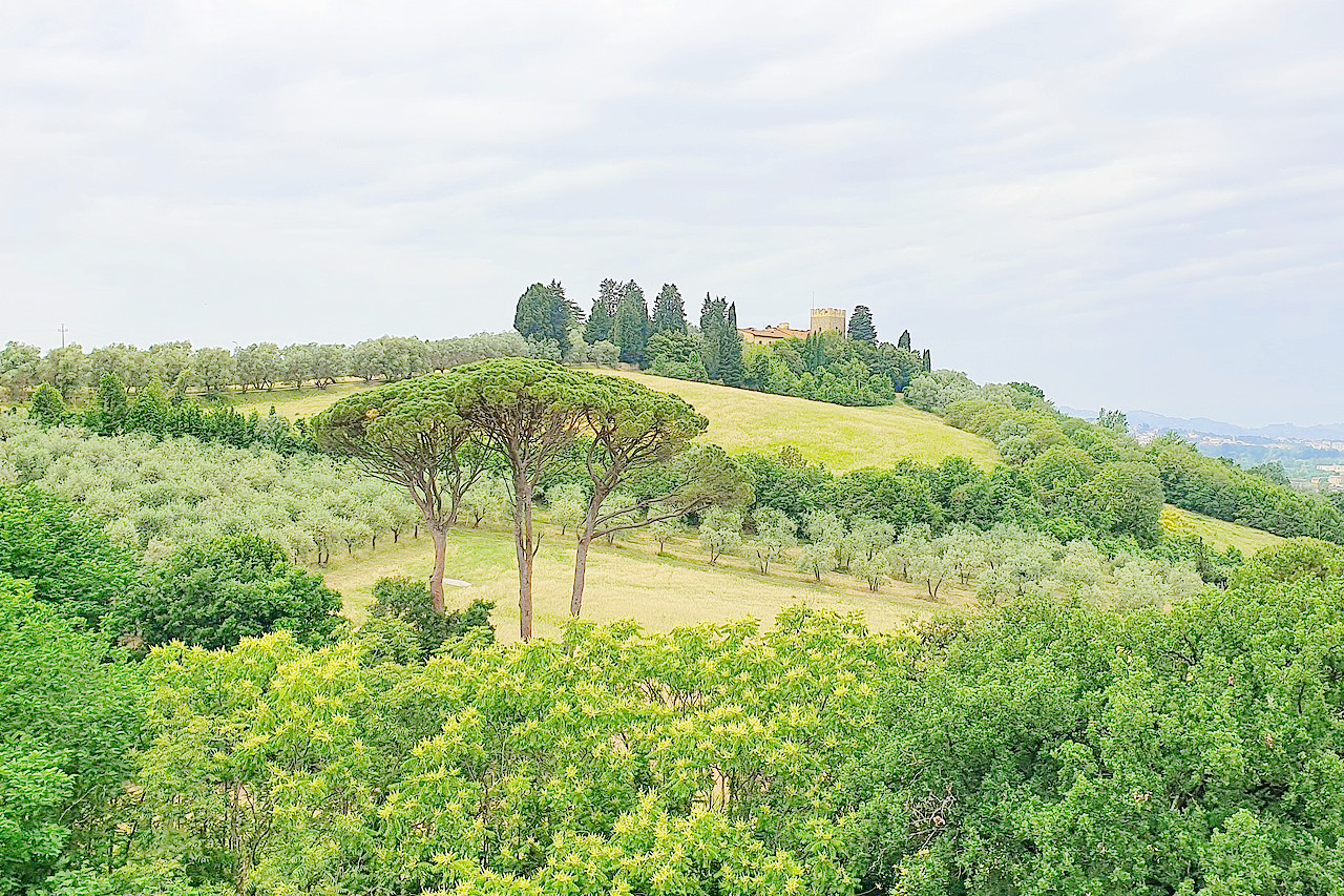 Villa Monte Cascioli in Scandicci
Climate Map
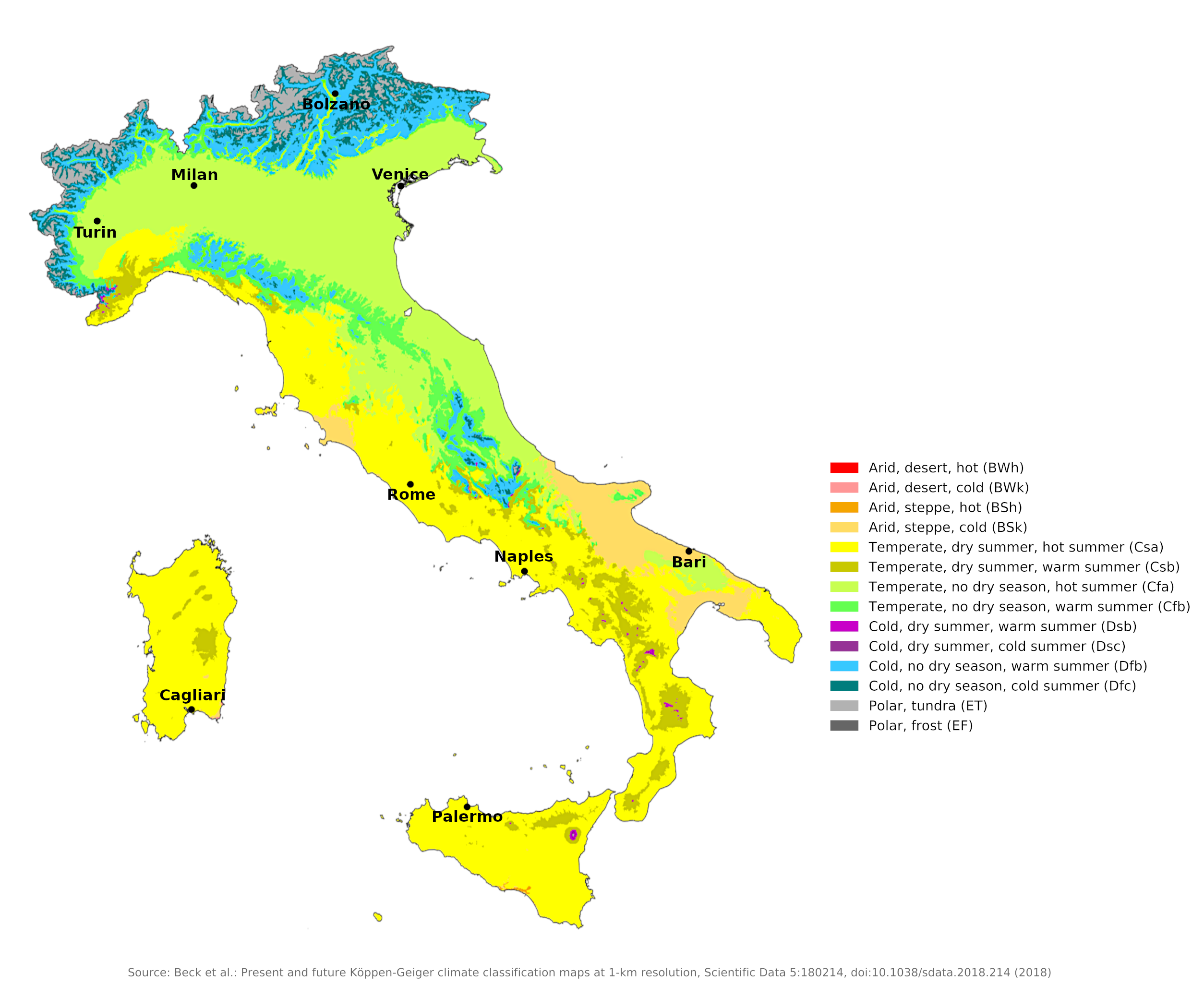 Climate map of Italy
What is the climate of Italy like?
Italy can be divided into three distinct geographical regions: the southern side of the Alps where Italy borders France, Switzerland, Austria, and Slovenia; the great plain of the Po valley from Turin to Venice; and the long and mountainous peninsula of central and southern Italy together with the large islands of Sardinia and Sicily.
Because Italy is mountainous, stretching 1,200 kilometers (750 miles) from central Europe to almost Africa, the climate is by no means uniform. Sunshine and low humidity lure visitors to the resort towns of the Alps and the coasts of the Italian Riviera and Peninsula. In most parts of Italy, hot summers are tempered by ocean or sea breezes, but the south can experience dry, sweltering summers. Sea temperatures in Italy are usually warm enough for comfortable bathing from mid-May to October, but the water can be surprisingly cold on warm, sunny days in spring.
Several parts of Italy have strong seasonal winds. On the Ligurian coast, the winter wind from the Alps, called Mistral, brings clear skies and falling temperatures. A bitterly cold wind from the Alps called Bora blows with strong gusts around Trieste and the northern Adriatic coast. A less strong, drier north wind called Tramontana affects the west side of the peninsula.
Occasionally, all parts of Italy experience very high temperatures in summer and even in autumn when the Sirocco is blowing. This is a warm, humid wind that originates over North Africa and gets its humidity as it crosses the Mediterranean Sea. A Scirocco weather spell in the fall often ends with very heavy rain accompanied by thunder.
Alpine Italy
Including Piemonte (Turin), Trentino Alto-Adige (Trento).
In the Italian Alps, where the higher mountains rise to over 3,000 meters (10,000 feet), the climate is similar to that of the Swiss and Austrian Alps. However, the rainfall on the Italian side is slightly heavier. In the Alps, temperatures vary with the degree the slopes are shaded from the sun, and precipitation varies with relief. Areas above 1,500 meters (5,000 feet) receive snow, and some peaks remain snow-capped year-round. The Eastern Alps tend to be wetter, but overall the Alpine region has a maximum of rain in summer and light precipitation in cooler months.
| Climate data for Bolzano (1971–2000) | |||||||||||||
|---|---|---|---|---|---|---|---|---|---|---|---|---|---|
| Month | Jan | Feb | Mar | Apr | May | Jun | Jul | Aug | Sep | Oct | Nov | Dec | Year |
| Average high °C (°F) | 6.3 (43.3) | 9.5 (49.1) | 15.0 (59.0) | 18.5 (65.3) | 23.2 (73.8) | 26.5 (79.7) | 29.0 (84.2) | 28.5 (83.3) | 24.3 (75.7) | 17.9 (64.2) | 11.0 (51.8) | 6.6 (43.9) | 18.0 (64.4) |
| Daily mean °C (°F) | 0.9 (33.6) | 3.7 (38.7) | 8.5 (47.3) | 12.0 (53.6) | 16.5 (61.7) | 19.8 (67.6) | 22.3 (72.1) | 21.8 (71.2) | 17.9 (64.2) | 12.1 (53.8) | 5.4 (41.7) | 1.4 (34.5) | 11.9 (53.4) |
| Average low °C (°F) | −4.5 (23.9) | −2.1 (28.2) | 2.1 (35.8) | 5.4 (41.7) | 9.8 (49.6) | 13.2 (55.8) | 15.5 (59.9) | 15.1 (59.2) | 11.6 (52.9) | 6.2 (43.2) | −0.1 (31.8) | −3.7 (25.3) | 5.7 (42.3) |
| Average precipitation mm (inches) | 23.5 (0.93) | 22.8 (0.90) | 36.9 (1.45) | 50.2 (1.98) | 75.2 (2.96) | 84.6 (3.33) | 92.3 (3.63) | 86.2 (3.39) | 70.9 (2.79) | 84.4 (3.32) | 49.9 (1.96) | 34.6 (1.36) | 711.5 (28.01) |
| Source: Servizio Meteorologico | |||||||||||||
The lower slopes and valleys of the Italian Alps are slightly warmer in both summer and winter. Summer is typically the rainiest season, and thunderstorms are common in spring, summer, and fall. The mildest winters and the warmest and sunniest summers can be found in the region around Lake Maggiore, Lake Como and Lake Garda. There is an average of three to four hours of sunshine per day in winter and up to nine hours in summer. Sometimes a föhn wind blows from the north, raising temperatures and lowering humidity.
| Climate data for Turin (1971–2000) | |||||||||||||
|---|---|---|---|---|---|---|---|---|---|---|---|---|---|
| Month | Jan | Feb | Mar | Apr | May | Jun | Jul | Aug | Sep | Oct | Nov | Dec | Year |
| Average high °C (°F) | 6.6 (43.9) | 9.1 (48.4) | 13.4 (56.1) | 16.6 (61.9) | 20.7 (69.3) | 24.8 (76.6) | 27.9 (82.2) | 27.1 (80.8) | 23.0 (73.4) | 17.3 (63.1) | 11.1 (52.0) | 7.6 (45.7) | 17.1 (62.8) |
| Daily mean °C (°F) | 2.0 (35.6) | 4.3 (39.7) | 8.1 (46.6) | 11.1 (52.0) | 15.5 (59.9) | 19.4 (66.9) | 22.4 (72.3) | 21.8 (71.2) | 17.8 (64.0) | 12.4 (54.3) | 6.5 (43.7) | 3.1 (37.6) | 12.0 (53.6) |
| Average low °C (°F) | −2.5 (27.5) | −0.7 (30.7) | 2.7 (36.9) | 5.7 (42.3) | 10.4 (50.7) | 14.0 (57.2) | 16.9 (62.4) | 16.5 (61.7) | 12.7 (54.9) | 7.4 (45.3) | 1.9 (35.4) | −1.6 (29.1) | 7.0 (44.6) |
| Average precipitation mm (inches) | 47.8 (1.88) | 47.1 (1.85) | 72.5 (2.85) | 113.3 (4.46) | 145.3 (5.72) | 104.3 (4.11) | 70.5 (2.78) | 76.1 (3.00) | 83.8 (3.30) | 106.1 (4.18) | 69.1 (2.72) | 45.1 (1.78) | 981.0 (38.62) |
| Source: Servizio Meteorologico | |||||||||||||
The Po Valley and North Italian Plain
Including Friuli-Venezia-Giulia (Trieste), Veneto (Venice, Verona), Lombardy (Milan), Emilia-Romagna (Bologna, Ravenna).
This is a remarkably flat and low-lying region with a dense population and great agricultural productivity. It stretches from Turin to Venice and almost to the port of Trieste. It has a distinctive climate with rainfall well distributed throughout the year. The summers are as hot and almost as sunny as in southern Italy. Winters are surprisingly cold for about three months. Fog, frost and snow are fairly common and this area is colder than Paris or London in the middle of winter.
This region includes the warmer Venetian coast and the sub-alpine lakes, which have a particularly favorable climate because they contain large amounts of water, moderate air temperatures and because their shores are sheltered from the wind. Overall, the northern Italian lowlands are protected by mountains on three sides (except the east). Cooler in winter than the Italian peninsula, it receives little winter rainfall, although humidity is high and freezing temperatures are common. Spring on the plains is warm and humid, summer is hot and humid with frequent storms, and autumn is characterized by heavy rainfall.
Summer and autumn precipitation often takes the form of thunderstorms, but rain falls on a few days. Hours of sunshine range from an average of two to three per day in winter to nine in summer. In winter, the small area around Trieste is sometimes hit by strong and gusty winds, the Bora, bringing very cold air from central Europe (see the Milan and Venice examples).
| Climate data for Milan (1971–2000) | |||||||||||||
|---|---|---|---|---|---|---|---|---|---|---|---|---|---|
| Month | Jan | Feb | Mar | Apr | May | Jun | Jul | Aug | Sep | Oct | Nov | Dec | Year |
| Average high °C (°F) | 5.9 (42.6) | 9.0 (48.2) | 14.3 (57.7) | 17.4 (63.3) | 22.3 (72.1) | 26.2 (79.2) | 29.2 (84.6) | 28.5 (83.3) | 24.4 (75.9) | 17.8 (64.0) | 10.7 (51.3) | 6.4 (43.5) | 17.7 (63.9) |
| Daily mean °C (°F) | 2.5 (36.5) | 4.7 (40.5) | 9.0 (48.2) | 12.2 (54.0) | 17.0 (62.6) | 20.8 (69.4) | 23.6 (74.5) | 23.0 (73.4) | 19.2 (66.6) | 13.4 (56.1) | 7.2 (45.0) | 3.3 (37.9) | 13.0 (55.4) |
| Average low °C (°F) | −0.9 (30.4) | 0.3 (32.5) | 3.8 (38.8) | 7.0 (44.6) | 11.6 (52.9) | 15.4 (59.7) | 18.0 (64.4) | 17.6 (63.7) | 14.0 (57.2) | 9.0 (48.2) | 3.7 (38.7) | 0.1 (32.2) | 8.3 (46.9) |
| Average precipitation mm (inches) | 58.7 (2.31) | 49.2 (1.94) | 65.0 (2.56) | 75.5 (2.97) | 95.5 (3.76) | 66.7 (2.63) | 66.8 (2.63) | 88.8 (3.50) | 93.1 (3.67) | 122.4 (4.82) | 76.7 (3.02) | 61.7 (2.43) | 920.1 (36.22) |
| Source: Servizio Meteorologico | |||||||||||||
| Climate data for Venice (1971–2000) | |||||||||||||
|---|---|---|---|---|---|---|---|---|---|---|---|---|---|
| Month | Jan | Feb | Mar | Apr | May | Jun | Jul | Aug | Sep | Oct | Nov | Dec | Year |
| Average high °C (°F) | 6.6 (43.9) | 8.6 (47.5) | 12.5 (54.5) | 16.1 (61.0) | 21.5 (70.7) | 24.9 (76.8) | 27.7 (81.9) | 27.5 (81.5) | 23.5 (74.3) | 18.0 (64.4) | 11.6 (52.9) | 7.4 (45.3) | 17.2 (63.0) |
| Daily mean °C (°F) | 3.3 (37.9) | 4.7 (40.5) | 8.3 (46.9) | 12.0 (53.6) | 17.1 (62.8) | 20.5 (68.9) | 23.0 (73.4) | 22.6 (72.7) | 18.9 (66.0) | 13.8 (56.8) | 7.8 (46.0) | 4.0 (39.2) | 13.0 (55.4) |
| Average low °C (°F) | −0.1 (31.8) | 0.8 (33.4) | 4.1 (39.4) | 7.8 (46.0) | 12.7 (54.9) | 16.1 (61.0) | 18.3 (64.9) | 17.7 (63.9) | 14.3 (57.7) | 9.6 (49.3) | 4.0 (39.2) | 0.6 (33.1) | 8.8 (47.8) |
| Average precipitation mm (inches) | 47.0 (1.85) | 48.3 (1.90) | 48.8 (1.92) | 70.0 (2.76) | 66.0 (2.60) | 78.0 (3.07) | 63.9 (2.52) | 64.8 (2.55) | 72.0 (2.83) | 73.5 (2.89) | 65.5 (2.58) | 50.6 (1.99) | 748.4 (29.46) |
| Source: Servizio Meteorologico | |||||||||||||
Peninsular Italy and the Islands
Including Liguria (Genoa), Tuscany (Florence, Pisa, Siena), Umbria (Perugia, Assisi), Campania (Monte Cassino, Naples, Pompeii, Sorrento, Capri), Puglia (Brindisi), Lazio (Rome), Sardinia (Cagliari), Sicily (Palermo).
The narrowness of the Italian peninsula and the small size of the islands allow maritime influences to penetrate inland, warming the autumn and ensuring gradual seasonal changes. The presence of the mountainous hinterland of the Apennines also modifies the weather of the coasts, protecting the west coast in particular. The coastal regions, where most of the big cities are located, have a typical Mediterranean climate with mild winters and hot and mostly dry summers. However, the Adriatic coasts of the eastern peninsula have a drier, harsher climate than that of the east coast.
The Appennines rise to over 1,800 meters (6,000 feet), hence the climate of the interior is very different from the coastal areas, especially in winter. The higher areas are cold, wet and often snow-covered. In winter the mountains have a long snow season from November to May.
The length and intensity of the summer dry season increases towards the south (compare Rome, Naples and Bari). There is not much difference in temperature at sea level from north to south. The east coast of the peninsula is not as wet as the west coast. The east coast north of Pescara is occasionally hit by the cold Bora winds in winter and spring, but the wind is less strong here than around Trieste.
| Climate data for Rome (1971–2000) | |||||||||||||
|---|---|---|---|---|---|---|---|---|---|---|---|---|---|
| Month | Jan | Feb | Mar | Apr | May | Jun | Jul | Aug | Sep | Oct | Nov | Dec | Year |
| Average high °C (°F) | 12.6 (54.7) | 14.0 (57.2) | 16.5 (61.7) | 18.9 (66.0) | 23.9 (75.0) | 28.1 (82.6) | 31.5 (88.7) | 31.7 (89.1) | 27.5 (81.5) | 22.4 (72.3) | 16.5 (61.7) | 13.2 (55.8) | 21.4 (70.5) |
| Daily mean °C (°F) | 7.4 (45.3) | 8.4 (47.1) | 10.4 (50.7) | 12.9 (55.2) | 17.3 (63.1) | 21.2 (70.2) | 24.2 (75.6) | 24.5 (76.1) | 20.9 (69.6) | 16.4 (61.5) | 11.2 (52.2) | 8.2 (46.8) | 15.3 (59.5) |
| Average low °C (°F) | 2.1 (35.8) | 2.7 (36.9) | 4.3 (39.7) | 6.8 (44.2) | 10.8 (51.4) | 14.3 (57.7) | 16.9 (62.4) | 17.3 (63.1) | 14.3 (57.7) | 10.5 (50.9) | 5.8 (42.4) | 3.1 (37.6) | 9.1 (48.4) |
| Average precipitation mm (inches) | 69.5 (2.74) | 75.8 (2.98) | 59.0 (2.32) | 76.2 (3.00) | 49.1 (1.93) | 40.7 (1.60) | 21.0 (0.83) | 34.1 (1.34) | 71.8 (2.83) | 107.0 (4.21) | 109.9 (4.33) | 84.4 (3.32) | 798.5 (31.44) |
| Source: Servizio Meteorologico | |||||||||||||
| Climate data for Naples (1971–2000) | |||||||||||||
|---|---|---|---|---|---|---|---|---|---|---|---|---|---|
| Month | Jan | Feb | Mar | Apr | May | Jun | Jul | Aug | Sep | Oct | Nov | Dec | Year |
| Average high °C (°F) | 13.0 (55.4) | 13.1 (55.6) | 15.6 (60.1) | 17.4 (63.3) | 23.0 (73.4) | 26.5 (79.7) | 29.8 (85.6) | 30.8 (87.4) | 26.8 (80.2) | 22.7 (72.9) | 17.3 (63.1) | 14.3 (57.7) | 20.9 (69.6) |
| Daily mean °C (°F) | 8.7 (47.7) | 8.8 (47.8) | 11.0 (51.8) | 12.9 (55.2) | 17.8 (64.0) | 21.3 (70.3) | 24.3 (75.7) | 24.9 (76.8) | 21.4 (70.5) | 17.1 (62.8) | 12.5 (54.5) | 9.9 (49.8) | 15.9 (60.6) |
| Average low °C (°F) | 4.4 (39.9) | 4.5 (40.1) | 6.3 (43.3) | 8.4 (47.1) | 12.6 (54.7) | 16.2 (61.2) | 18.8 (65.8) | 19.1 (66.4) | 16.0 (60.8) | 12.1 (53.8) | 7.8 (46.0) | 5.6 (42.1) | 11.0 (51.8) |
| Average precipitation mm (inches) | 92.1 (3.63) | 95.3 (3.75) | 77.9 (3.07) | 98.6 (3.88) | 59.0 (2.32) | 32.8 (1.29) | 28.5 (1.12) | 35.5 (1.40) | 88.9 (3.50) | 135.5 (5.33) | 152.1 (5.99) | 112.0 (4.41) | 1,008.2 (39.69) |
| Source: Servizio Meteorologico | |||||||||||||
| Climate data for Bari (1971–2000) | |||||||||||||
|---|---|---|---|---|---|---|---|---|---|---|---|---|---|
| Month | Jan | Feb | Mar | Apr | May | Jun | Jul | Aug | Sep | Oct | Nov | Dec | Year |
| Average high °C (°F) | 12.6 (54.7) | 12.9 (55.2) | 15.0 (59.0) | 18.0 (64.4) | 22.8 (73.0) | 26.8 (80.2) | 29.2 (84.6) | 29.2 (84.6) | 25.9 (78.6) | 21.5 (70.7) | 16.8 (62.2) | 13.9 (57.0) | 20.4 (68.7) |
| Daily mean °C (°F) | 8.8 (47.8) | 8.9 (48.0) | 10.7 (51.3) | 13.3 (55.9) | 17.8 (64.0) | 21.8 (71.2) | 24.3 (75.7) | 24.3 (75.7) | 21.1 (70.0) | 17.1 (62.8) | 12.7 (54.9) | 10.1 (50.2) | 15.9 (60.6) |
| Average low °C (°F) | 4.9 (40.8) | 4.8 (40.6) | 6.3 (43.3) | 8.6 (47.5) | 12.9 (55.2) | 16.7 (62.1) | 19.3 (66.7) | 19.4 (66.9) | 16.3 (61.3) | 12.6 (54.7) | 8.6 (47.5) | 6.2 (43.2) | 11.4 (52.5) |
| Average precipitation mm (inches) | 53.7 (2.11) | 64.2 (2.53) | 42.0 (1.65) | 40.5 (1.59) | 34.9 (1.37) | 23.3 (0.92) | 25.4 (1.00) | 30.4 (1.20) | 59.7 (2.35) | 61.5 (2.42) | 72.7 (2.86) | 54.3 (2.14) | 562.6 (22.14) |
| Source: Servizio Meteorologico | |||||||||||||
The entire Italian peninsula and the large islands of Sicily and Sardinia have very changeable weather in autumn, winter and spring in marked contrast to the consistently sunny weather of summer. Disturbed weather can last through late May and begin anytime after early September. Throughout the winter, however, cloudy rainy days alternate with mild, sunny weather.
The fewest rainy days and the most hours of sunshine are in the extreme south of the mainland as well as in Sicily and Sardinia. Here there is an average of four to five hours of sunshine in winter and up to ten or eleven hours of sunshine in summer. The summer heat is usually tempered on the coast by sea breezes during the day, but nights can be occasionally warm and even muggy (see Palermo and Cagliari).
| Climate data for Palermo (1971-2000) | |||||||||||||
|---|---|---|---|---|---|---|---|---|---|---|---|---|---|
| Month | Jan | Feb | Mar | Apr | May | Jun | Jul | Aug | Sep | Oct | Nov | Dec | Year |
| Average high °C (°F) | 14.7 (58.5) | 14.5 (58.1) | 16.4 (61.5) | 18.7 (65.7) | 23.3 (73.9) | 27.2 (81.0) | 29.8 (85.6) | 30.5 (86.9) | 27.5 (81.5) | 23.5 (74.3) | 19.0 (66.2) | 15.8 (60.4) | 21.7 (71.1) |
| Daily mean °C (°F) | 11.8 (53.2) | 11.5 (52.7) | 13.0 (55.4) | 15.1 (59.2) | 19.3 (66.7) | 23.2 (73.8) | 25.7 (78.3) | 26.6 (79.9) | 23.8 (74.8) | 20.1 (68.2) | 15.9 (60.6) | 13.0 (55.4) | 18.3 (64.9) |
| Average low °C (°F) | 8.9 (48.0) | 8.5 (47.3) | 9.6 (49.3) | 11.4 (52.5) | 15.3 (59.5) | 19.2 (66.6) | 21.7 (71.1) | 22.7 (72.9) | 20.1 (68.2) | 16.7 (62.1) | 12.9 (55.2) | 10.2 (50.4) | 14.8 (58.6) |
| Average precipitation mm (inches) | 97.5 (3.84) | 109.9 (4.33) | 78.2 (3.08) | 65.1 (2.56) | 36.2 (1.43) | 17.9 (0.70) | 6.7 (0.26) | 31.8 (1.25) | 65.3 (2.57) | 105.6 (4.16) | 117.5 (4.63) | 123.7 (4.87) | 855.4 (33.68) |
| Source: Servizio Meteorologico | |||||||||||||
| Climate data for Cagliari (1971-2000) | |||||||||||||
|---|---|---|---|---|---|---|---|---|---|---|---|---|---|
| Month | Jan | Feb | Mar | Apr | May | Jun | Jul | Aug | Sep | Oct | Nov | Dec | Year |
| Average high °C (°F) | 14.3 (57.7) | 14.8 (58.6) | 16.5 (61.7) | 18.6 (65.5) | 22.9 (73.2) | 27.3 (81.1) | 30.4 (86.7) | 30.8 (87.4) | 27.4 (81.3) | 23.1 (73.6) | 18.3 (64.9) | 15.4 (59.7) | 21.7 (71.1) |
| Daily mean °C (°F) | 9.9 (49.8) | 10.3 (50.5) | 11.8 (53.2) | 13.8 (56.8) | 17.7 (63.9) | 21.8 (71.2) | 24.7 (76.5) | 25.2 (77.4) | 22.3 (72.1) | 18.4 (65.1) | 13.8 (56.8) | 11.0 (51.8) | 16.7 (62.1) |
| Average low °C (°F) | 5.5 (41.9) | 5.8 (42.4) | 7.1 (44.8) | 8.9 (48.0) | 12.4 (54.3) | 16.2 (61.2) | 18.9 (66.0) | 19.6 (67.3) | 17.1 (62.8) | 13.7 (56.7) | 9.3 (48.7) | 6.6 (43.9) | 11.8 (53.2) |
| Average precipitation mm (inches) | 49.7 (1.96) | 53.3 (2.10) | 40.4 (1.59) | 39.7 (1.56) | 26.1 (1.03) | 11.9 (0.47) | 4.1 (0.16) | 7.5 (0.30) | 34.9 (1.37) | 52.6 (2.07) | 58.4 (2.30) | 48.9 (1.93) | 428 (16.9) |
| Source: Servizio Meteorologico | |||||||||||||
When is the best time to visit Italy?
The weather varies from hot to freezing depending on place and time of year. April to November are usually sunny and warm–hot in midsummer. The south is pleasant all year round, but there is a rainy season in winter.
References
- E. A. Pearce, Charles Gordon Smith, (1990) The Hutchinson World Weather Guide, John Murray Press. ISBN 1859863426
- Timothy L. Gall, (ed.), (2003), Worldmark Encyclopedia of the Nations, Eleventh Edition, Thomson Gale
- Federal Research Division, Library of Congress, (1985), Italy: a country study. Claitor's Pub. Division.
- Hugh Chisholm, (ed.), (1911), Encyclopædia Britannica, Eleventh edition, Cambridge University Press
The Climate of
Italy
In summary:
Italy has considerable climatic variation, from snowcaps in parts of the Alps to subtropical conditions in Sicily. The northern part of the country has a continental climate, with cold winters and warm summers. Farther south, the climate becomes Mediterranean, with cool winters; hot, dry summers; and less variation between seasons.
Rainfall is lower in the south and higher in the north. Average annual rainfall ranges from about 500 mm (20 in) in the south to 2000 mm (80 in) in the Alpine regions.