The Climate of
Spain
 Iglesia de San Bartolomé, Granada
Climate Map
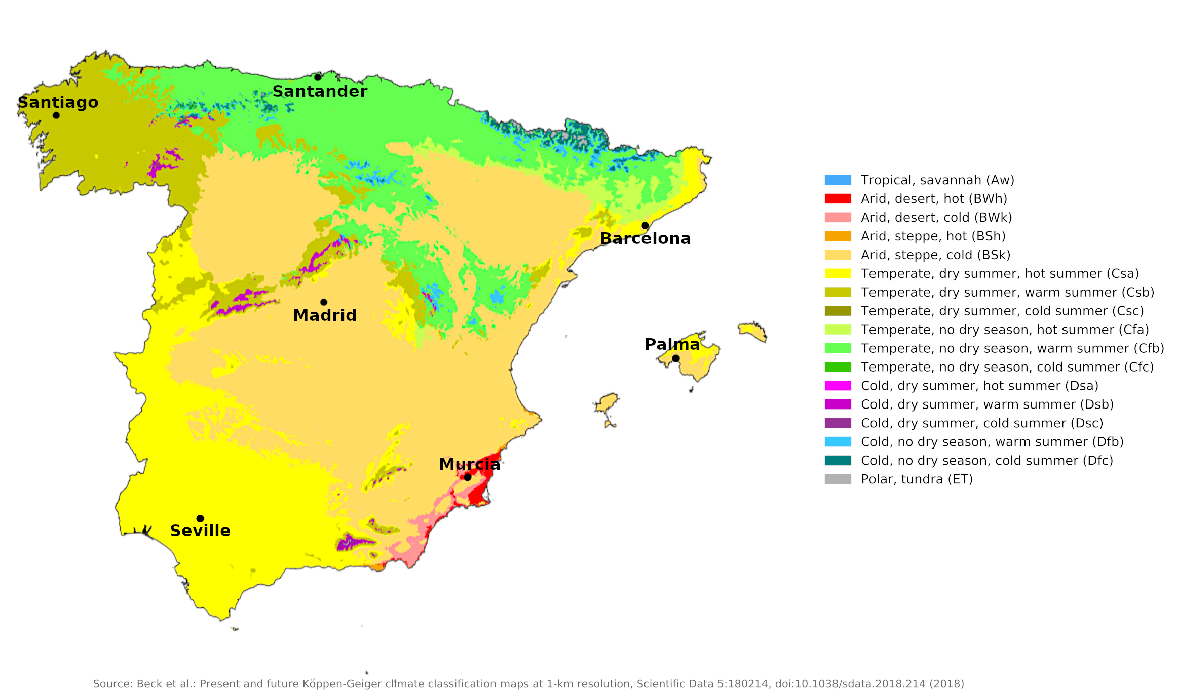 Climate map of Spain
What is the climate of Spain like?
Spain is a country almost the size of France. Together with Portugal, with which it shares a long land border to the west, it forms a large peninsula south of the Pyrenees, with the Atlantic Ocean and the Mediterranean Sea on its west and north sides in the south and east. The size of the peninsula and the different climatic influences of the Atlantic and the Mediterranean lead to different climate zones within Spain. It is a mistake to assume that the whole country has a typical Mediterranean climate, such as that found in the tourist areas along the east and south coasts and in the Balearic Islands.
To the north, the Pyrenees and Cantabrian Mountains rise to an altitude of between 1,800 and 3,000 meters (6,000–10,000 feet). Much of inland Spain is a plateau averaging 450–900 meters (1,500–3,000 feet) in elevation, crossed by a series of mountain ranges (Sierras). In the south of the country (Andalusia), the valley of the Guadalquivir river forms a wide plain, to the south of this lies the high Sierra Nevada, which dominates the narrow Mediterranean coast. These large differences in altitude and the contrast between the coast and the interior give Spain a range of climate and weather conditions. Although most of the country is hot and sunny in summer, winter temperatures vary greatly; Coastal areas are mild, but the interior is often cold and snowy. Skiing is available on the mountain ranges closest to most of the country's major cities.
Spain experiences three climatic types: maritime, continental, and Mediterranean. Hence the country can be divided into three climatic regions: the north and northwest; central Spain; and the Mediterranean coastlines of the east and south including the Balearic Islands. The Canary Islands are also politically a part of Spain.
North and Northwestern Spain
Including Galicia; most of Asturias, Cantabria, and Pais Vasco; northwestern Navarra.
A maritime climate prevails in the northern part of the country, from the Pyrenees to the northwest region, characterized by relatively mild winters, warm but not hot summers, and generally abundant rainfall spread out over the year. This is the part of the country most affected by depressions coming in from the Atlantic, especially in autumn and winter. It is the rainiest and cloudiest part of Spain. Autumn (October through December) is the wettest season, while July is the driest month.
Although summers are cooler, cloudier, and wetter than elsewhere in the country, there is still a significant amount of warm, sunny weather. The moderating effects of the sea, however, abate in the inland areas, where temperatures are a little more extreme than temperatures on the coast. Rainfall decreases from west to east in the Pyrenees, but is quite high on the seaward slopes of Cantabria and the extreme north-west (Galicia). Daily hours of sunshine average between three in winter and seven or eight in summer. See the climate of Santiago de Compostela (in Galicia) and Santander.
The high humidity and the prevailing offshore winds make fog and mist common along the northwest coast; this phenomenon is less frequent a short distance inland, however, because the mountains form a barrier keeping out the sea moisture.
| Climate data for Santiago de Compostela (1981–2010) | |||||||||||||
|---|---|---|---|---|---|---|---|---|---|---|---|---|---|
| Month | Jan | Feb | Mar | Apr | May | Jun | Jul | Aug | Sep | Oct | Nov | Dec | Year |
| Average high °C (°F) | 11.2 (52.2) | 12.5 (54.5) | 15.0 (59.0) | 16.1 (61.0) | 18.6 (65.5) | 22.2 (72.0) | 24.3 (75.7) | 24.7 (76.5) | 22.8 (73.0) | 18.1 (64.6) | 14.1 (57.4) | 11.9 (53.4) | 17.6 (63.7) |
| Daily mean °C (°F) | 7.7 (45.9) | 8.3 (46.9) | 10.2 (50.4) | 11.2 (52.2) | 13.6 (56.5) | 16.8 (62.2) | 18.6 (65.5) | 19.0 (66.2) | 17.4 (63.3) | 13.8 (56.8) | 10.4 (50.7) | 8.5 (47.3) | 13.0 (55.4) |
| Average low °C (°F) | 4.1 (39.4) | 4.1 (39.4) | 5.4 (41.7) | 6.2 (43.2) | 8.5 (47.3) | 11.3 (52.3) | 13.0 (55.4) | 13.3 (55.9) | 11.9 (53.4) | 9.5 (49.1) | 6.7 (44.1) | 5.0 (41.0) | 8.3 (46.9) |
| Average precipitation mm (inches) | 210 (8.3) | 167 (6.6) | 146 (5.7) | 146 (5.7) | 135 (5.3) | 72 (2.8) | 43 (1.7) | 57 (2.2) | 107 (4.2) | 226 (8.9) | 217 (8.5) | 261 (10.3) | 1,787 (70.4) |
| Source: Agencia Estatal de Meteorología | |||||||||||||
| Climate data for Santander (1981–2010) | |||||||||||||
|---|---|---|---|---|---|---|---|---|---|---|---|---|---|
| Month | Jan | Feb | Mar | Apr | May | Jun | Jul | Aug | Sep | Oct | Nov | Dec | Year |
| Average high °C (°F) | 13.6 (56.5) | 13.8 (56.8) | 15.7 (60.3) | 16.6 (61.9) | 19.1 (66.4) | 21.6 (70.9) | 23.6 (74.5) | 24.2 (75.6) | 22.8 (73.0) | 20.3 (68.5) | 16.3 (61.3) | 14.2 (57.6) | 18.5 (65.3) |
| Daily mean °C (°F) | 9.7 (49.5) | 9.8 (49.6) | 11.3 (52.3) | 12.4 (54.3) | 15.1 (59.2) | 17.8 (64.0) | 19.8 (67.6) | 20.3 (68.5) | 18.6 (65.5) | 16.1 (61.0) | 12.5 (54.5) | 10.5 (50.9) | 14.5 (58.1) |
| Average low °C (°F) | 5.8 (42.4) | 5.7 (42.3) | 7.0 (44.6) | 8.3 (46.9) | 11.1 (52.0) | 13.9 (57.0) | 16.0 (60.8) | 16.4 (61.5) | 14.4 (57.9) | 11.8 (53.2) | 8.7 (47.7) | 6.7 (44.1) | 10.5 (50.9) |
| Average precipitation mm (inches) | 106 (4.2) | 92 (3.6) | 88 (3.5) | 102 (4.0) | 78 (3.1) | 58 (2.3) | 52 (2.0) | 73 (2.9) | 83 (3.3) | 120 (4.7) | 157 (6.2) | 118 (4.6) | 1,129 (44.4) |
| Source: Agencia Estatal de Meteorología | |||||||||||||
Central Spain
Including Aragon, Castilla-León, Castilla-la-Mancha, Extremadura, La Rioja, Madrid; inland Andalusia and Andalusia's Atlantic coast; southern inland parts of Asturias, Cantabria, Navarra, and Pais Vasco; western inland parts of Catalonia, Murcia, and Valencia.
Much of Spain experiences a continental climate characterized by wide daily and seasonal variations in temperature and by low, irregular rainfall with high rates of evaporation that leave the land arid. Rainfall is generally light in most of the interior, although winter snowfall can be quite heavy and stay on the mountains for a long time. In late summer, much of the country looks parched and barren after the long summer drought. Summers are generally hot, particularly in the Guadalquivir Valley to the south, which has some of the highest temperatures in Europe. Spring and early summer are the wettest seasons in many places, but rainfall is scant and not very effective, often falling in short, heavy showers.
Winters have frequent cold snaps with biting winds blowing off the snow-capped Sierras. Dust and hot winds are the worst features of summer weather, but low humidity makes the heat more bearable than some coastal regions. The length of the dry summer season increases from north to south. Even during the winter season, rain is irregular and unreliable. Sunshine duration is quite high all year round, ranging from an average of five hours a day in winter to twelve hours in midsummer. Madrid is representative of conditions in the higher parts of inland Spain, while Seville in the Guadalquivir Valley is typical of the lower and hotter parts of Andalusia.
| Climate data for Madrid (1981–2010) | |||||||||||||
|---|---|---|---|---|---|---|---|---|---|---|---|---|---|
| Month | Jan | Feb | Mar | Apr | May | Jun | Jul | Aug | Sep | Oct | Nov | Dec | Year |
| Average high °C (°F) | 9.8 (49.6) | 12.0 (53.6) | 16.3 (61.3) | 18.2 (64.8) | 22.2 (72.0) | 28.2 (82.8) | 32.1 (89.8) | 31.3 (88.3) | 26.4 (79.5) | 19.4 (66.9) | 13.5 (56.3) | 10.0 (50.0) | 19.9 (67.8) |
| Daily mean °C (°F) | 6.3 (43.3) | 7.9 (46.2) | 11.2 (52.2) | 12.9 (55.2) | 16.7 (62.1) | 22.2 (72.0) | 25.6 (78.1) | 25.1 (77.2) | 20.9 (69.6) | 15.1 (59.2) | 9.9 (49.8) | 6.9 (44.4) | 15.0 (59.0) |
| Average low °C (°F) | 2.7 (36.9) | 3.7 (38.7) | 6.2 (43.2) | 7.7 (45.9) | 11.3 (52.3) | 16.1 (61.0) | 19.0 (66.2) | 18.8 (65.8) | 15.4 (59.7) | 10.7 (51.3) | 6.3 (43.3) | 3.6 (38.5) | 10.1 (50.2) |
| Average precipitation mm (inches) | 33 (1.3) | 35 (1.4) | 25 (1.0) | 45 (1.8) | 51 (2.0) | 21 (0.8) | 12 (0.5) | 10 (0.4) | 22 (0.9) | 60 (2.4) | 58 (2.3) | 51 (2.0) | 423 (16.8) |
| Source: Agencia Estatal de Meteorología | |||||||||||||
| Climate data for Seville (1981–2010) | |||||||||||||
|---|---|---|---|---|---|---|---|---|---|---|---|---|---|
| Month | Jan | Feb | Mar | Apr | May | Jun | Jul | Aug | Sep | Oct | Nov | Dec | Year |
| Average high °C (°F) | 16.2 (61.2) | 18.1 (64.6) | 21.9 (71.4) | 23.4 (74.1) | 27.2 (81.0) | 32.2 (90.0) | 36.0 (96.8) | 35.5 (95.9) | 31.7 (89.1) | 26.0 (78.8) | 20.2 (68.4) | 16.6 (61.9) | 25.4 (77.7) |
| Daily mean °C (°F) | 11.0 (51.8) | 12.5 (54.5) | 15.6 (60.1) | 17.3 (63.1) | 20.7 (69.3) | 25.1 (77.2) | 28.2 (82.8) | 27.9 (82.2) | 25.0 (77.0) | 20.2 (68.4) | 15.1 (59.2) | 11.9 (53.4) | 19.2 (66.6) |
| Average low °C (°F) | 5.7 (42.3) | 7.0 (44.6) | 9.2 (48.6) | 11.1 (52.0) | 14.2 (57.6) | 18.0 (64.4) | 20.3 (68.5) | 20.4 (68.7) | 18.2 (64.8) | 14.4 (57.9) | 10.0 (50.0) | 7.3 (45.1) | 13.0 (55.4) |
| Average precipitation mm (inches) | 66 (2.6) | 50 (2.0) | 36 (1.4) | 54 (2.1) | 31 (1.2) | 10 (0.4) | 2 (0.1) | 5 (0.2) | 27 (1.1) | 68 (2.7) | 91 (3.6) | 99 (3.9) | 539 (21.2) |
| Source: Agencia Estatal de Meteorología | |||||||||||||
Mediterranean Spain—the East and South Coastal Regions
Including southeastern Andalucia (Costa del Sol); coastal Catalonia (Costa Brava); coastal Murcia; coastal Valencia (Costa Bianca).
A Mediterranean climate extends from the Andalusian Plain along the southern and eastern coasts up to the Pyrenees. This area includes the internationally renowned resorts—the Costa Brava to the north and the Costa del Sol to the south. Temperatures in the Mediterranean region usually are more moderate in both summer and winter, and daily temperature changes are more limited than those inland. Sunshine duration is high: from six hours a day in winter to twelve in midsummer. Winters are mild and much warmer than inland. While summers are hot and at times humid, the afternoon heat is usually tempered by sea breezes.
Total rainfall in this region is lower than in the rest of Spain, and is generally slight, irregular, and unreliable. There is very little rain from June to August, but north of Valencia the coast can experience occasional heavy thunderstorms in summer. Around Barcelona and further north, autumn tends to be wetter than winter; here the total amount of precipitation is greater than in the south, sometimes even dry in winter. In the drier regions there are significant differences in the amount of precipitation from year to year. Barcelona is representative of the northern coastal regions and Murcia is typical of the drier southern regions.
In the south, conditions can occasionally get quite uncomfortable when a hot, dry wind (the Leveche) blows from North Africa. These winds, which sometimes carry fine dust, are most common in spring. A cooler easterly wind (the Levante) blows along the southeast coast.
| Climate data for Barcelona (1987–2010) | |||||||||||||
|---|---|---|---|---|---|---|---|---|---|---|---|---|---|
| Month | Jan | Feb | Mar | Apr | May | Jun | Jul | Aug | Sep | Oct | Nov | Dec | Year |
| Average high °C (°F) | 14.8 (58.6) | 15.6 (60.1) | 17.4 (63.3) | 19.1 (66.4) | 22.5 (72.5) | 26.1 (79.0) | 28.6 (83.5) | 29.0 (84.2) | 26.0 (78.8) | 22.5 (72.5) | 17.9 (64.2) | 15.1 (59.2) | 21.2 (70.2) |
| Daily mean °C (°F) | 11.8 (53.2) | 12.4 (54.3) | 14.2 (57.6) | 15.8 (60.4) | 19.3 (66.7) | 22.9 (73.2) | 25.7 (78.3) | 26.1 (79.0) | 23.0 (73.4) | 19.5 (67.1) | 14.9 (58.8) | 12.3 (54.1) | 18.2 (64.8) |
| Average low °C (°F) | 8.8 (47.8) | 9.3 (48.7) | 10.9 (51.6) | 12.5 (54.5) | 16.1 (61.0) | 19.8 (67.6) | 22.7 (72.9) | 23.1 (73.6) | 20.0 (68.0) | 16.5 (61.7) | 11.9 (53.4) | 9.5 (49.1) | 15.1 (59.2) |
| Average precipitation mm (inches) | 43.7 (1.72) | 31.4 (1.24) | 33.0 (1.30) | 47.7 (1.88) | 47.4 (1.87) | 32.5 (1.28) | 25.1 (0.99) | 40.8 (1.61) | 81.9 (3.22) | 96.5 (3.80) | 45.1 (1.78) | 46.8 (1.84) | 571.9 (22.53) |
| Source: Servei Meteorològic de Catalunya | |||||||||||||
| Climate data for Murcia (1984–2010) | |||||||||||||
|---|---|---|---|---|---|---|---|---|---|---|---|---|---|
| Month | Jan | Feb | Mar | Apr | May | Jun | Jul | Aug | Sep | Oct | Nov | Dec | Year |
| Average high °C (°F) | 16.6 (61.9) | 18.4 (65.1) | 20.9 (69.6) | 23.3 (73.9) | 26.6 (79.9) | 31.0 (87.8) | 34.0 (93.2) | 34.2 (93.6) | 30.4 (86.7) | 25.6 (78.1) | 20.3 (68.5) | 17.2 (63.0) | 24.9 (76.8) |
| Daily mean °C (°F) | 10.6 (51.1) | 12.2 (54.0) | 14.3 (57.7) | 16.5 (61.7) | 20.0 (68.0) | 24.2 (75.6) | 27.2 (81.0) | 27.6 (81.7) | 24.2 (75.6) | 19.8 (67.6) | 14.6 (58.3) | 11.5 (52.7) | 18.6 (65.5) |
| Average low °C (°F) | 4.7 (40.5) | 5.9 (42.6) | 7.7 (45.9) | 9.7 (49.5) | 13.3 (55.9) | 17.4 (63.3) | 20.3 (68.5) | 20.9 (69.6) | 18.0 (64.4) | 13.9 (57.0) | 8.9 (48.0) | 5.8 (42.4) | 12.3 (54.1) |
| Average precipitation mm (inches) | 27 (1.1) | 27 (1.1) | 30 (1.2) | 25 (1.0) | 28 (1.1) | 18 (0.7) | 3 (0.1) | 8 (0.3) | 32 (1.3) | 36 (1.4) | 32 (1.3) | 29 (1.1) | 297 (11.7) |
| Source: Agencia Estatal de Meteorología | |||||||||||||
The Balearic Islands
The Balearic Islands, which include Mallorca, Menorca and Ibiza, lie 170 to 250 kilometers (100-150 miles) east of Spain and are a popular winter and summer resort for visitors from northern Europe. They have a climate similar to that of south-eastern Spain, as illustrated by the climate of Palma in Mallorca.
Mallorca has hot summers and autumn and spring are warm and nice, and winters are mild. The mountainous section of northern Mallorca tends to be cooler and wetter with occasional snow in winter. Menorca is a windy island, making it cool in summer and wet in winter. Ibiza and Formentera are the driest and warmest islands.
| Climate data for Palma (1981-2010) | |||||||||||||
|---|---|---|---|---|---|---|---|---|---|---|---|---|---|
| Month | Jan | Feb | Mar | Apr | May | Jun | Jul | Aug | Sep | Oct | Nov | Dec | Year |
| Average high °C (°F) | 15.4 (59.7) | 15.5 (59.9) | 17.2 (63.0) | 19.2 (66.6) | 22.5 (72.5) | 26.5 (79.7) | 29.4 (84.9) | 29.8 (85.6) | 27.1 (80.8) | 23.7 (74.7) | 19.3 (66.7) | 16.5 (61.7) | 21.8 (71.2) |
| Daily mean °C (°F) | 11.9 (53.4) | 11.9 (53.4) | 13.4 (56.1) | 15.5 (59.9) | 18.8 (65.8) | 22.7 (72.9) | 25.7 (78.3) | 26.2 (79.2) | 23.5 (74.3) | 20.2 (68.4) | 15.8 (60.4) | 13.1 (55.6) | 18.2 (64.8) |
| Average low °C (°F) | 8.3 (46.9) | 8.4 (47.1) | 9.6 (49.3) | 11.7 (53.1) | 15.1 (59.2) | 18.9 (66.0) | 21.9 (71.4) | 22.5 (72.5) | 19.9 (67.8) | 16.6 (61.9) | 12.3 (54.1) | 9.7 (49.5) | 14.6 (58.3) |
| Average precipitation mm (inches) | 43 (1.7) | 37 (1.5) | 28 (1.1) | 39 (1.5) | 36 (1.4) | 11 (0.4) | 6 (0.2) | 22 (0.9) | 52 (2.0) | 69 (2.7) | 59 (2.3) | 48 (1.9) | 449 (17.7) |
| Source: Agencia Estatal de Meteorología | |||||||||||||
When is the best time to visit Spain?
It can be rainy on the northern Atlantic coasts, but summers are pleasant. Central Spain has very hot summers and cold winters, so is best visited in spring or fall. Mediterranean Spain can also be rather hot in the summer; fall, winter, and spring are milder.
References
- E. A. Pearce, Charles Gordon Smith, (1990) The Hutchinson World Weather Guide, John Murray Press. ISBN 1859863426
- Timothy L. Gall, (ed.), (2003), Worldmark Encyclopedia of the Nations, Eleventh Edition, Thomson Gale
- Federal Research Division, Library of Congress, (1990), Spain: a country study. Claitor's Pub. Division.
- Hugh Chisholm, (ed.), (1911), Encyclopædia Britannica, Eleventh edition, Cambridge University Press
The Climate of
Spain
In summary:
The climate of Spain varies from a maritime climate in the northwest to a Mediterranean climate in the southeast, with continental conditions prevailing inbetween. The northern coastal regions are cool and humid; temperatures on the north coast range from an average of 10°C (50°F) in winter to 20°C (68°F) during summer. The central plateau is cold in the winter and hot in the summer; Madrid has a winter average of about 8°C (46°F) and a summer average of 25°C (77°F). In Andalucía the climate is temperate except in summer, when temperatures sometimes reach above 40°C (104°F).
The northern coastal regions have an average annual rainfall of 1000 mm (40 in); the southern coastal belt has 400–800 mm (16–32 in); and the interior central plain averages no more than 500 mm (20 in) annually.