The Climate of
Yemen
 Entrance to Sanaa University
Climate Map
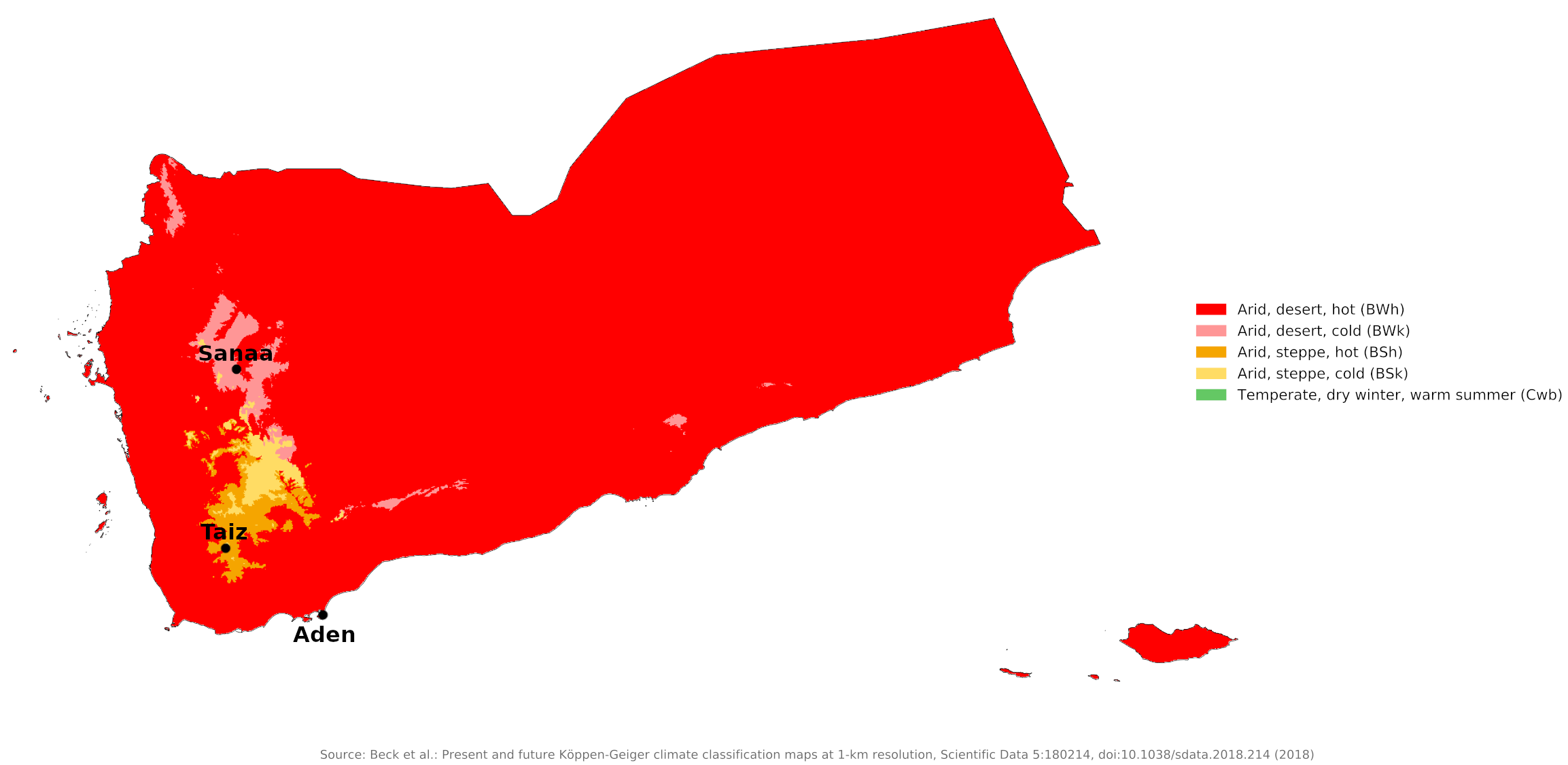 Climate map of Yemen
What is the climate of Yemen like?
Yemen is a mountainous country occupying the southwestern portion of the Arabian peninsula. It has a narrow coastal plain on the Red Sea, a long coastline on the Arabian Sea, and land borders with Saudi Arabia and Oman. The far north includes a small portion of the great sand desert of the Rub' al Khali which is mainly in Saudi Arabia.
Western Highlands
In Yemen the Western Highlands rise steeply to a mountainous interior over 3,600 meters (12,000 feet) above sea level. It is an exceptional part of Arabia, since the mountains lie in the path of monsoon winds that bring rain to the country from March to September. The amount of rainfall varies considerably with the altitude, but in general rain becomes heavier as one moves north to south. The western-exposed highlands also tend to receive particularly heavy rainfall.
Rainfall in the highlands ranges from 265 millimeters (10 inches) at Sanaa to 800 millimeters (32 inches) in the monsoon area of the extreme southwest. The amount of precipitation sharply decreases on the eastern sides of the Highlands.
In these higher regions temperatures are much lower than elsewhere in Arabia. Here the climate is quite pleasant. Summers are temperate and winters are cool, with some frost. Temperatures vary from 20°C (68°F) in July, the hottest month, to 13°C (55°F) in January. The average year-round temperature at Sanaa is 16°C (61°F).
Climatic conditions for the interior highlands are shown by that for the cities of Sanaa and Taiz.
| Climate data for Sanaa | |||||||||||||
|---|---|---|---|---|---|---|---|---|---|---|---|---|---|
| Month | Jan | Feb | Mar | Apr | May | Jun | Jul | Aug | Sep | Oct | Nov | Dec | Year |
| Average high °C (°F) | 22.3 (72.1) | 24.7 (76.5) | 25.6 (78.1) | 24.8 (76.6) | 25.7 (78.3) | 28.2 (82.8) | 26.6 (79.9) | 25.9 (78.6) | 25.1 (77.2) | 22.2 (72.0) | 20.3 (68.5) | 20.5 (68.9) | 24.3 (75.8) |
| Daily mean °C (°F) | 12.6 (54.7) | 14.1 (57.4) | 16.3 (61.3) | 16.6 (61.9) | 18.0 (64.4) | 19.3 (66.7) | 20.0 (68.0) | 19.6 (67.3) | 17.8 (64.0) | 15.0 (59.0) | 12.9 (55.2) | 12.4 (54.3) | 16.2 (61.2) |
| Average low °C (°F) | 3.0 (37.4) | 3.6 (38.5) | 7.0 (44.6) | 8.5 (47.3) | 10.4 (50.7) | 10.5 (50.9) | 13.4 (56.1) | 13.3 (55.9) | 10.6 (51.1) | 7.9 (46.2) | 5.5 (41.9) | 4.4 (39.9) | 8.2 (46.7) |
| Average precipitation mm (inches) | 5 (0.2) | 5 (0.2) | 17 (0.7) | 48 (1.9) | 29 (1.1) | 6 (0.2) | 50 (2.0) | 77 (3.0) | 13 (0.5) | 2 (0.1) | 8 (0.3) | 5 (0.2) | 265 (10.4) |
| Source: Climate-Data.org | |||||||||||||
| Climate data for Taiz | |||||||||||||
|---|---|---|---|---|---|---|---|---|---|---|---|---|---|
| Month | Jan | Feb | Mar | Apr | May | Jun | Jul | Aug | Sep | Oct | Nov | Dec | Year |
| Average high °C (°F) | 24.3 (75.7) | 26.4 (79.5) | 27.9 (82.2) | 28.3 (82.9) | 29.0 (84.2) | 31.3 (88.3) | 32.5 (90.5) | 31.7 (89.1) | 31.3 (88.3) | 31.1 (88.0) | 27.6 (81.7) | 26.1 (79.0) | 29.0 (84.2) |
| Daily mean °C (°F) | 17.7 (63.9) | 19.9 (67.8) | 22.1 (71.8) | 23.6 (74.5) | 24.3 (75.7) | 25.6 (78.1) | 26.4 (79.5) | 25.4 (77.7) | 24.6 (76.3) | 24.0 (75.2) | 21.7 (71.1) | 20.0 (68.0) | 22.9 (73.2) |
| Average low °C (°F) | 11.1 (52.0) | 13.3 (55.9) | 16.3 (61.3) | 18.8 (65.8) | 19.5 (67.1) | 19.9 (67.8) | 20.2 (68.4) | 19.1 (66.4) | 17.8 (64.0) | 16.9 (62.4) | 15.7 (60.3) | 13.9 (57.0) | 16.9 (62.4) |
| Average precipitation mm (inches) | 9 (0.4) | 12 (0.5) | 37 (1.5) | 68 (2.7) | 89 (3.5) | 73 (2.9) | 60 (2.4) | 89 (3.5) | 110 (4.3) | 91 (3.6) | 17 (0.7) | 5 (0.2) | 660 (26.2) |
| Source: Journal of Environmental Protection and Hydrological Sciences | |||||||||||||
Coasts and lowland interior
On the coast, rainfall is low throughout the year, and most of the coastal plain is desert. Temperatures and humidity are high throughout the year and the period from June to September is the most uncomfortable time, when midday temperatures regularly rise to near 38°C (100°F) with a high humidity. Daily sea breezes help to mitigate the heat on the coast, but the Red Sea coast is particularly hot and humid.
Inland in the hills both temperatures and humidity are a little lower. It is not uncommon, however, for the northern and eastern sections of the country to receive no rain for five years or more. Short, heavy showers fall unpredictably—usually during April, July, August, and September—leaving an average rainfall of 50 millimeters (2 inches) a year. Sandstorms often appear in both summer and winter as winds sweep across Yemen.
Climatic conditions along the southern coast are shown by that for the city of Aden.
| Climate data for Aden | |||||||||||||
|---|---|---|---|---|---|---|---|---|---|---|---|---|---|
| Month | Jan | Feb | Mar | Apr | May | Jun | Jul | Aug | Sep | Oct | Nov | Dec | Year |
| Average high °C (°F) | 28.5 (83.3) | 28.6 (83.5) | 30.2 (86.4) | 32.2 (90.0) | 34.1 (93.4) | 36.6 (97.9) | 35.9 (96.6) | 35.3 (95.5) | 35.4 (95.7) | 33.0 (91.4) | 30.7 (87.3) | 28.9 (84.0) | 32.4 (90.3) |
| Daily mean °C (°F) | 25.7 (78.3) | 26.0 (78.8) | 27.2 (81.0) | 28.9 (84.0) | 31.0 (87.8) | 32.7 (90.9) | 32.1 (89.8) | 31.5 (88.7) | 31.6 (88.9) | 28.9 (84.0) | 27.1 (80.8) | 26.0 (78.8) | 29.1 (84.4) |
| Average low °C (°F) | 22.6 (72.7) | 23.2 (73.8) | 24.0 (75.2) | 25.6 (78.1) | 27.7 (81.9) | 28.8 (83.8) | 28.0 (82.4) | 27.5 (81.5) | 27.8 (82.0) | 24.6 (76.3) | 23.2 (73.8) | 22.9 (73.2) | 25.5 (77.9) |
| Average precipitation mm (inches) | 6 (0.2) | 3 (0.1) | 5 (0.2) | 2 (0.1) | 1 (0.0) | 0 (0) | 3 (0.1) | 3 (0.1) | 5 (0.2) | 1 (0.0) | 3 (0.1) | 5 (0.2) | 36 (1.4) |
| Source: Deutscher Wetterdienst | |||||||||||||
References
- E. A. Pearce, Charles Gordon Smith, (1990) The Hutchinson World Weather Guide, John Murray Press. ISBN 1859863426
- Timothy L. Gall, (ed.), (2003), Worldmark Encyclopedia of the Nations, Eleventh Edition, Thomson Gale
- Federal Research Division, Library of Congress, (1986), The Yemens: country studies. Claitor's Pub. Division.
- Hugh Chisholm, (ed.), (1911), Encyclopædia Britannica, Eleventh edition, Cambridge University Press
The Climate of
Yemen
In summary:
Yemen has a narrow coastal plain backed by flat-topped hills and rugged mountains. The coast has a very hot, desert climate, with temperatures regularly rising to near 38°C (100°F) with a high humidity. The climate of the highlands is much cooler. Here, summers are temperate and winters are cool Temperatures vary from 20°C (68°F) in July, the hottest month, to 13°C (55°F) in January.
Rainfall in Yemen shows great regional variation. Less than 120 mm (5 in) of rain falls on the coastal lowlands. In the highlands it ranges from 300 mm (12 in) at Sanaa to 800 mm (32 in) in the extreme southwest. Most rain falls between March and September.