.jpg)
.jpg&oldid=707327694)
.jpg)
.jpg&oldid=656176741)
.jpg)
.jpg&oldid=655985829)
.jpg)
.jpg&oldid=674577409)
The Geography of
Benin
Why visit Benin?
Benin has a unique blend of culture, history, geography and nature. It boasts a wealth of animals and plants from those which inhabit the savannah to the wildlife of the sea coast.
Contents
Map
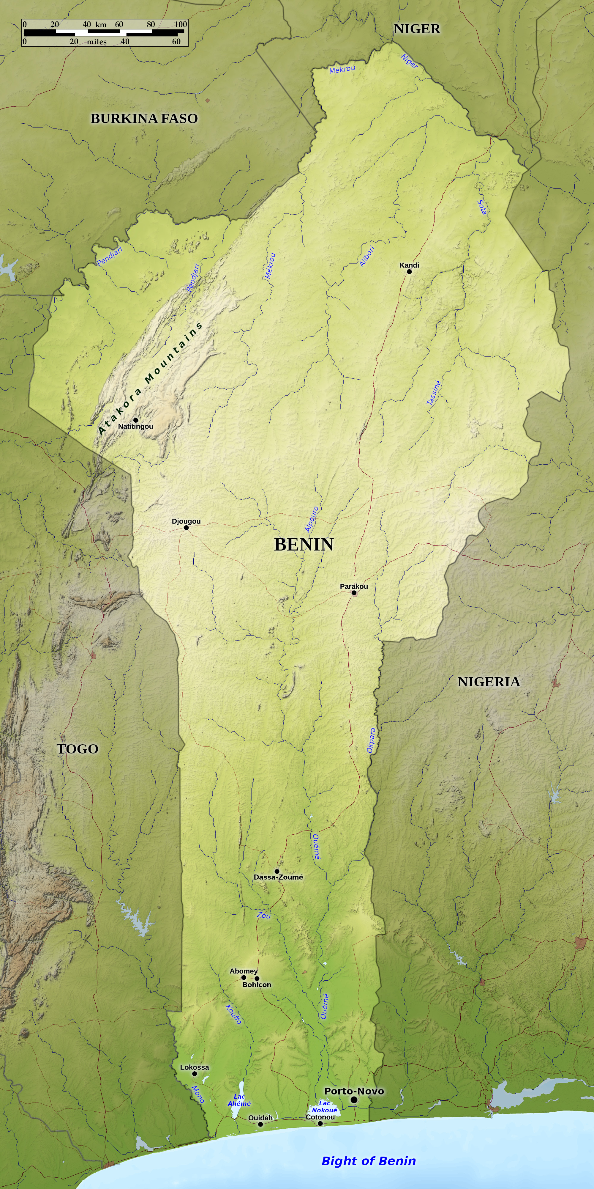 Relief map of Benin
What is the landscape of Benin like?
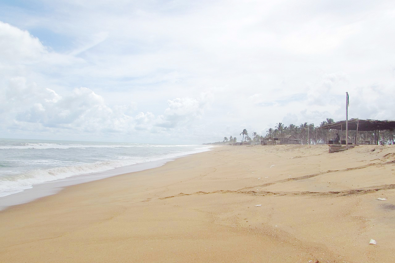
The coast of Benin lies on a wide bay in the Gulf of Guinea called the Bight of Benin. Benin's coastal belt consists of sandbars that form part of the country's coastline and impede access to the ocean. The coast has no natural harbors, estuaries or islands. Coconut palms grow on this narrow coastal strip broken by lagoons and creeks. These lagoons run parallel the coast, from Grand Popo on the Togo border and connected to Lake Ahémé, to Porto-Novo in the east, where Benin's longest river, the Ouémé, flows.
For some 80 kilometers (50 miles) inland the country is flat, fertile land supporting oil palm plantations and interspersed with marshy areas. The central part of Benin is a wooded savanna with some hilly areas, such as the hills around the city of Dassa-Zoumé.
Further north, the Land steadily rises to the plateau of Upper Benin. In the north-west of the country, the Atakora Mountains extend south-west into Togo. They reach altitudes of 300 to 600 meters (1,000 to 2,000 feet). They are heavily forested and belong to the same system as the Togo Mountains to the south. This is one of the most scenic parts of Benin: the rolling hills are cut by gorges, waterfalls, rivers, and deep valleys. In the northeast of Benin the land sinks towards the Niger river basin.
What is the nature of Benin like?
Apart from small isolated patches, little ancient forest remains. The coastal strip's coconut plantations give way to oil palms and rônier palms that grow as far north as Abomey. A large part of the interior consists of undulating savanna country, with occasional patches of forest, containing a mix of the Guinea forest vegetation and the vegetation of the southern Sudan type. Trees include coconut, oil palm, ronier palm, ebony, shea nut, kapok, fromager, and Senegal mahogany.
What is the climate of Benin like?
See our main article: The Climate of Benin
Benin has a hot, humid, tropical climate with two rainy seasons in the south, one peaking in May or June, the other in October, but in the north there is a single rainy season starting in May or June.
In the north there is a single long dry season between October and April. At this time the dust-laden harmattan wind blows from the northeast. From December to February the dry harmattan wind from the north affects most of country, except the coast.
| Climate data for Cotonou (1961–1990) | |||||||||||||
|---|---|---|---|---|---|---|---|---|---|---|---|---|---|
| Month | Jan | Feb | Mar | Apr | May | Jun | Jul | Aug | Sep | Oct | Nov | Dec | Year |
| Average high °C (°F) | 30.8 (87.4) | 31.6 (88.9) | 31.9 (89.4) | 31.6 (88.9) | 31.0 (87.8) | 29.2 (84.6) | 28.0 (82.4) | 27.8 (82.0) | 28.4 (83.1) | 29.6 (85.3) | 30.9 (87.6) | 30.8 (87.4) | 30.1 (86.2) |
| Daily mean °C (°F) | 27.3 (81.1) | 28.5 (83.3) | 28.9 (84.0) | 28.6 (83.5) | 27.8 (82.0) | 26.5 (79.7) | 25.8 (78.4) | 25.6 (78.1) | 26.0 (78.8) | 26.7 (80.1) | 27.6 (81.7) | 27.3 (81.1) | 27.2 (81.0) |
| Average low °C (°F) | 23.8 (74.8) | 25.4 (77.7) | 25.9 (78.6) | 25.6 (78.1) | 24.6 (76.3) | 23.7 (74.7) | 23.7 (74.7) | 23.4 (74.1) | 23.6 (74.5) | 23.8 (74.8) | 24.3 (75.7) | 23.8 (74.8) | 24.3 (75.7) |
| Average precipitation mm (inches) | 9.2 (0.36) | 36.8 (1.45) | 73.8 (2.91) | 137.0 (5.39) | 196.9 (7.75) | 356.0 (14.02) | 147.0 (5.79) | 64.9 (2.56) | 99.0 (3.90) | 126.7 (4.99) | 41.4 (1.63) | 19.6 (0.77) | 1,308.3 (51.52) |
| Source: NOAA | |||||||||||||
.jpg) Lion cubs at Pendjari National Park
Lion cubs at Pendjari National Park
.jpg&oldid=707327680)
Benin
Fraternité, Justice, Travail
| Location: | Western Africa, bordering the Bight of Benin, between Nigeria and Togo |
| Coordinates: | 9° 30′ N, 2° 15′ E |
| Size: | • 680 km N-S; 330 km E-W • 420 miles N-S; 200 miles E-W |
| Terrain: | Mostly flat to undulating plain; some hills and low mountains |
| Climate: | Tropical; hot, humid in south; semiarid in north |
| Highest point: | 672 m / 2,205 ft |
| Forest: | 40% (2018 est.) |
| Population: | 13,754,688 (2022 est.) |
| Population density: | Low-medium (95/km²) |
| Capital: | Porto-Novo |
| Languages: | 55 languages; French (official); Fon and Yoruba are the most important indigenous languages in the south; half a dozen regionally important languages in the north, including Bariba and Fulfulde |
| Human Development Index: | Low (0.545) |
Related entries
-
Togo
• Travail, Liberté, Patrie -
Burkina Faso
• Unité, Progrès, Justice -
Ghana
• Culture, Warmth and Rhythm -
Niger
• Fraternité, Travail, Progrès -
Nigeria
• Heartbeat of Africa