The Climate of
Costa Rica
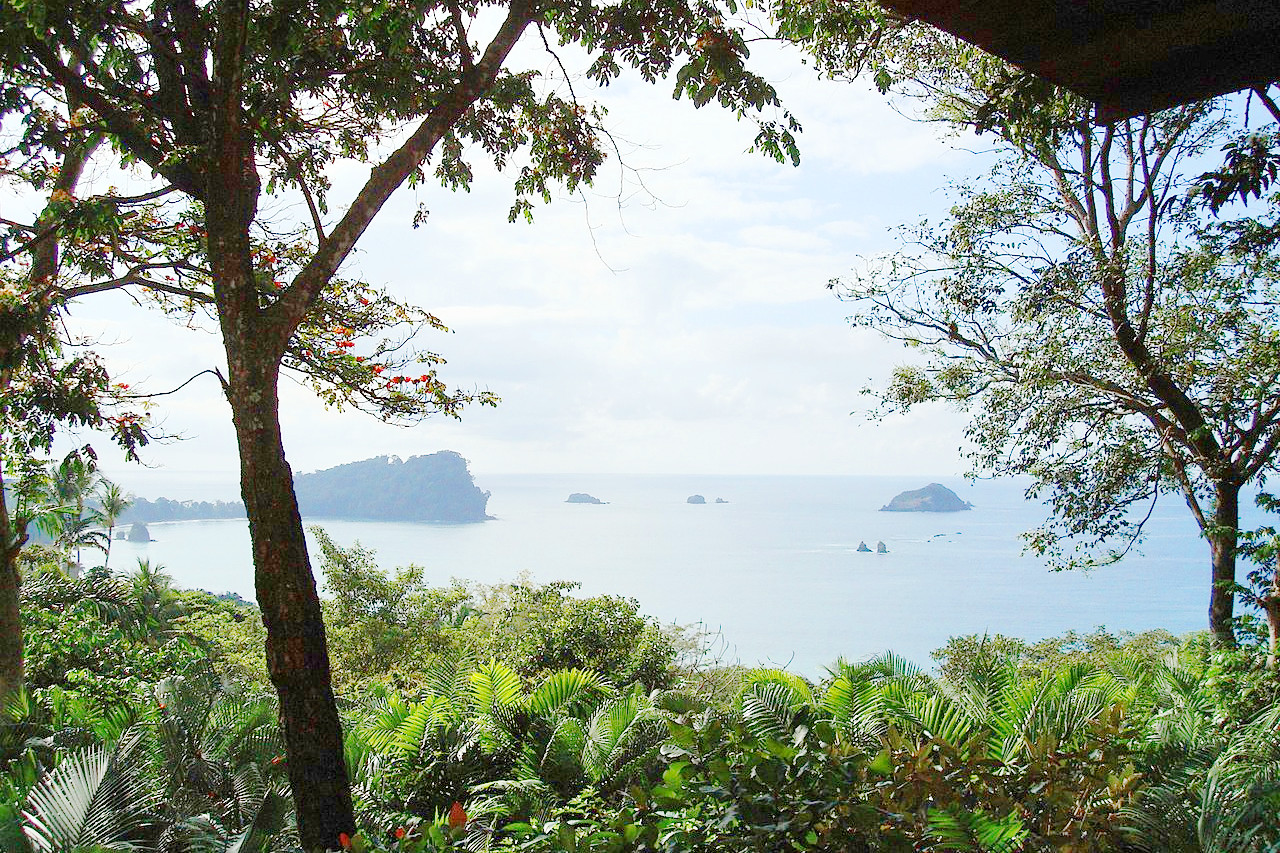 Manuel Antonio National Park
Climate Map
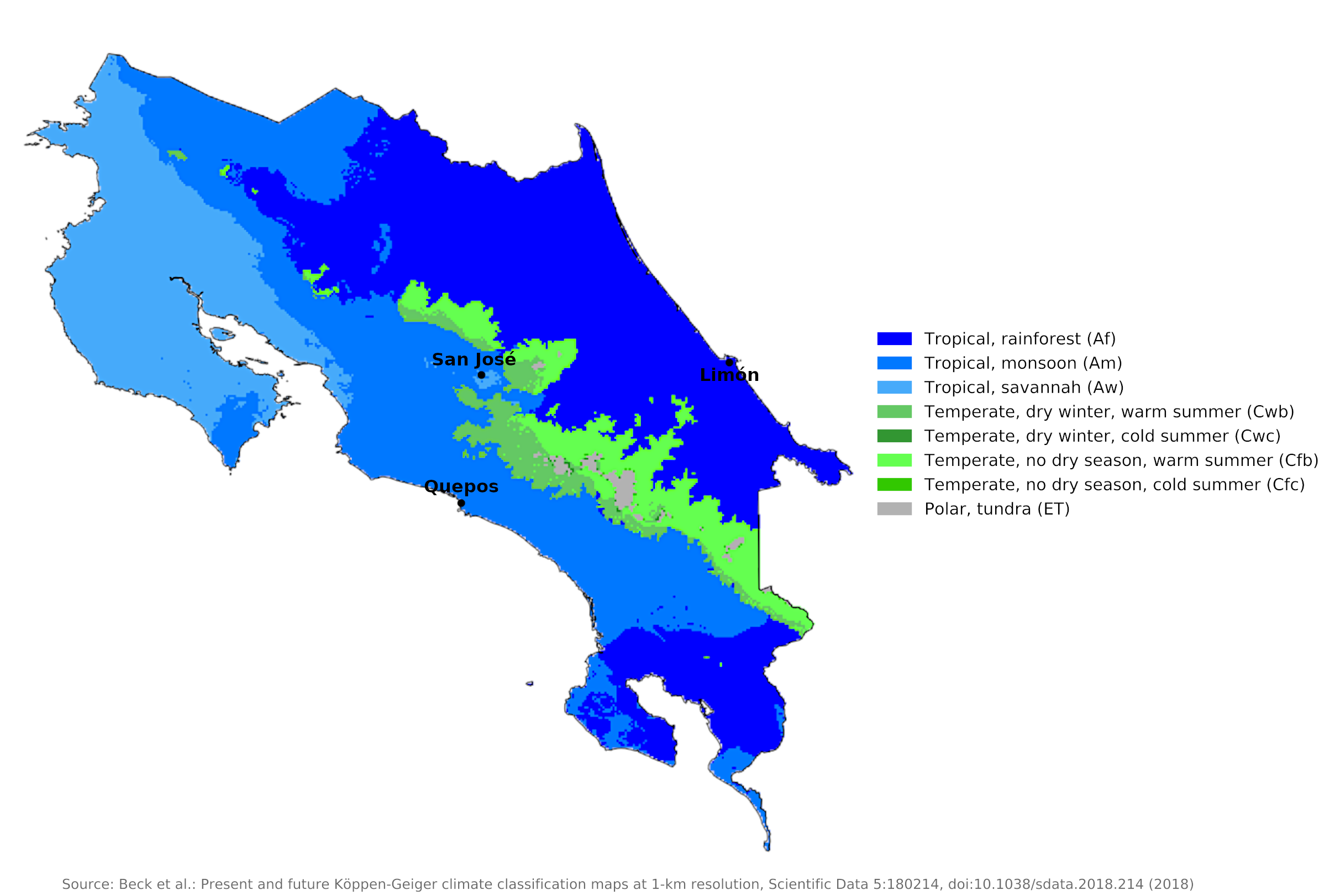 Climate map of Costa Rica
What is the climate of Costa Rica like?
Costa Rica is located in Central America and borders Panama on the south and Nicaragua on the north. It is about twice the size of Wales or the state of Massachusetts. Like other countries in Central America, Costa Rica is mountainous, with the highest peaks exceeding 3,700 meters (12,000 feet). It has a coastline on both the Pacific as well as the Caribbean.
Most of Costa Rica has two seasons: the rainy season from May to November (winter months) and the dry season from December to April (summer months). Although the country is entirely in the tropics, altitude plays a role in climate variability. There are three climate zones—tropical, temperate and cold.
Temperatures in Costa Rica vary primarily with elevation. But the incidence of rainfall, particularly the occurrence and length of a dry season, also affects mean annual temperatures. Thus, in the Caribbean lowlands and that part of the highlands exposed to the northeast trade winds, temperatures are a little cooler than at Pacific coast sites and highland locations that are protected from the northeast winds.
The tropical zone (tierra caliente), which includes the coastal and northern plains up to an elevation of 500 meters (1,600 feet), is characterized by heavy rainfall, and with daytime temperatures between 25 and 32°C (77 to 90°F). The climate of Quepos reflects sea level conditions on the Pacific coast. The Caribbean coast to the east (see Limón) is almost as hot and receives year-round rainfall. Although the heat is greater on the Pacific than on the Atlantic coast, it is less oppressive due to the prevailing cool breezes and lower humidity.
| Climate data for Quepos | |||||||||||||
|---|---|---|---|---|---|---|---|---|---|---|---|---|---|
| Month | Jan | Feb | Mar | Apr | May | Jun | Jul | Aug | Sep | Oct | Nov | Dec | Year |
| Average high °C (°F) | 32.2 (90.0) | 32.8 (91.0) | 34.0 (93.2) | 34.0 (93.2) | 32.9 (91.2) | 31.8 (89.2) | 32.1 (89.8) | 31.8 (89.2) | 31.3 (88.3) | 31.1 (88.0) | 30.6 (87.1) | 31.2 (88.2) | 32.2 (89.9) |
| Daily mean °C (°F) | 26.2 (79.2) | 26.5 (79.7) | 27.7 (81.9) | 28.2 (82.8) | 27.6 (81.7) | 26.7 (80.1) | 27.0 (80.6) | 26.6 (79.9) | 26.2 (79.2) | 26.2 (79.2) | 25.7 (78.3) | 25.7 (78.3) | 26.7 (80.1) |
| Average low °C (°F) | 20.2 (68.4) | 20.3 (68.5) | 21.4 (70.5) | 22.4 (72.3) | 22.4 (72.3) | 21.7 (71.1) | 22.0 (71.6) | 21.5 (70.7) | 21.2 (70.2) | 21.3 (70.3) | 20.8 (69.4) | 20.2 (68.4) | 21.3 (70.3) |
| Average precipitation mm (inches) | 68 (2.7) | 32 (1.3) | 54 (2.1) | 157 (6.2) | 392 (15.4) | 429 (16.9) | 453 (17.8) | 487 (19.2) | 523 (20.6) | 627 (24.7) | 374 (14.7) | 147 (5.8) | 3,743 (147.4) |
| Source: Climate-Data.org | |||||||||||||
| Climate data for Limón | |||||||||||||
|---|---|---|---|---|---|---|---|---|---|---|---|---|---|
| Month | Jan | Feb | Mar | Apr | May | Jun | Jul | Aug | Sep | Oct | Nov | Dec | Year |
| Average high °C (°F) | 28.8 (83.8) | 29.1 (84.4) | 29.7 (85.5) | 30.1 (86.2) | 30.4 (86.7) | 30.3 (86.5) | 29.6 (85.3) | 30.1 (86.2) | 30.6 (87.1) | 30.4 (86.7) | 29.4 (84.9) | 28.9 (84.0) | 29.8 (85.6) |
| Daily mean °C (°F) | 24.8 (76.6) | 24.9 (76.8) | 25.5 (77.9) | 26.1 (79.0) | 26.6 (79.9) | 26.6 (79.9) | 26.1 (79.0) | 26.3 (79.3) | 26.6 (79.9) | 26.4 (79.5) | 25.7 (78.3) | 25.1 (77.2) | 25.9 (78.6) |
| Average low °C (°F) | 20.7 (69.3) | 20.7 (69.3) | 21.2 (70.2) | 22.0 (71.6) | 22.8 (73.0) | 22.9 (73.2) | 22.6 (72.7) | 22.5 (72.5) | 22.5 (72.5) | 22.3 (72.1) | 21.9 (71.4) | 21.2 (70.2) | 21.9 (71.5) |
| Average precipitation mm (inches) | 319.7 (12.59) | 237.3 (9.34) | 208.5 (8.21) | 263.0 (10.35) | 333.5 (13.13) | 289.0 (11.38) | 426.3 (16.78) | 303.2 (11.94) | 142.1 (5.59) | 207.1 (8.15) | 400.6 (15.77) | 445.0 (17.52) | 3,575.3 (140.75) |
| Source: Instituto Meteorologico Nacional | |||||||||||||
The temperate zone (tierra templada), including the central valleys and plateaus, has elevations ranging from 500 to 1,500 meters (1,600 to 5,000 feet) with regular rainfall from April to November and average daytime temperatures of 23 to 29°C (73 to 84°F). The capital San José illustrates conditions in the Tierra Templada, where nights are much cooler than at sea level and days are less hot and humid.
| Climate data for San José | |||||||||||||
|---|---|---|---|---|---|---|---|---|---|---|---|---|---|
| Month | Jan | Feb | Mar | Apr | May | Jun | Jul | Aug | Sep | Oct | Nov | Dec | Year |
| Average high °C (°F) | 28.2 (82.8) | 29.1 (84.4) | 29.9 (85.8) | 30.3 (86.5) | 28.8 (83.8) | 28.2 (82.8) | 28.2 (82.8) | 28.3 (82.9) | 27.8 (82.0) | 27.1 (80.8) | 27.2 (81.0) | 27.9 (82.2) | 28.4 (83.1) |
| Daily mean °C (°F) | 22.6 (72.7) | 23.0 (73.4) | 23.5 (74.3) | 23.7 (74.7) | 22.9 (73.2) | 22.5 (72.5) | 22.6 (72.7) | 22.4 (72.3) | 22.0 (71.6) | 21.8 (71.2) | 21.9 (71.4) | 22.3 (72.1) | 22.6 (72.7) |
| Average low °C (°F) | 18.5 (65.3) | 18.7 (65.7) | 18.8 (65.8) | 19.1 (66.4) | 19.2 (66.6) | 19.0 (66.2) | 19.0 (66.2) | 18.8 (65.8) | 18.3 (64.9) | 18.5 (65.3) | 18.3 (64.9) | 18.3 (64.9) | 18.7 (65.7) |
| Average precipitation mm (inches) | 6.3 (0.25) | 10.2 (0.40) | 13.8 (0.54) | 79.9 (3.15) | 267.6 (10.54) | 280.1 (11.03) | 181.5 (7.15) | 276.9 (10.90) | 355.1 (13.98) | 330.6 (13.02) | 135.5 (5.33) | 33.5 (1.32) | 1,971 (77.61) |
| Source: Deutscher Wetterdienst | |||||||||||||
The Cold Zone (Tierra fría), which includes areas above 1,500 meters (5,000 feet), has daytime temperatures of 24 to 27°C (75 to 80°F) but nighttime temperatures of 10 to 13°C (50 to 55°F). It is less rainy but windier than the temperate regions. Frosts are common above 2,300 meters (7,500 feet), but snow is rare.
Rainfall
The tierra caliente is characterized by heavy rainfall; in the tierra templada it rains regularly from April to November; and the tierra fría is less rainy but windier than the temperate regions.
No area in Costa Rica suffers from an acute lack of rainfall, but there is considerable variation from region to region in mean annual rainfall and in the duration of the wet and dry seasons. The rainy season, which lasts from April to December during the southwest monsoon, is well defined on the Pacific slope. Towards the Atlantic, the trade winds can bring rain every month. Natural disasters that afflict the country include occasional hurricanes along the Atlantic coast and flooding of the lowlands at the start of the rainy season.
Normal rainfall is about 2,000 millimeters (80 inches), but because downpours are common, it can increase to 3,800 millimeters (150 inches) or even more. The northwest, by contrast, has only a six-month wet season and receives virtually no rain in the dry season. Despite its average annual rainfall of roughly 1,600 millimeters (64 inches), the Valle de Tempisque has known occasional drought.
References
- E. A. Pearce, Charles Gordon Smith, (1990) The Hutchinson World Weather Guide, John Murray Press. ISBN 1859863426
- Timothy L. Gall, (ed.), (2003), Worldmark Encyclopedia of the Nations, Eleventh Edition, Thomson Gale
- Federal Research Division, Library of Congress, (1983), Costa Rica: a country study. Claitor's Pub. Division.
- Hugh Chisholm, (ed.), (1911), Encyclopædia Britannica, Eleventh edition, Cambridge University Press
The Climate of
Costa Rica
In summary:
Costa Rica has two seasons: a wet season, from May to November, and a dry season, from December to April. There are three climatic zones. The torrid zone (tierra caliente), which includes the coastal and northern plains, has heavy rain, and a temperature range of 29–32°C (84–90°F). The temperate zone, including the central valleys and plateaus, has regular rains from April through November and a temperature range of 24–27°C (75–80°F). The cold zone, comprising areas higher than 1,500 m (5,000 ft), has a temperature range of 10–27°C (50–81°F) and is less rainy but more windy than the temperate regions.
The average annual rainfall for the country is more than 2500 mm (100 in).