The Climate of
Nicaragua
.jpg) Parque Central, Jinotega
Parque Central, Jinotega
.jpg&oldid=506658372)
Climate Map
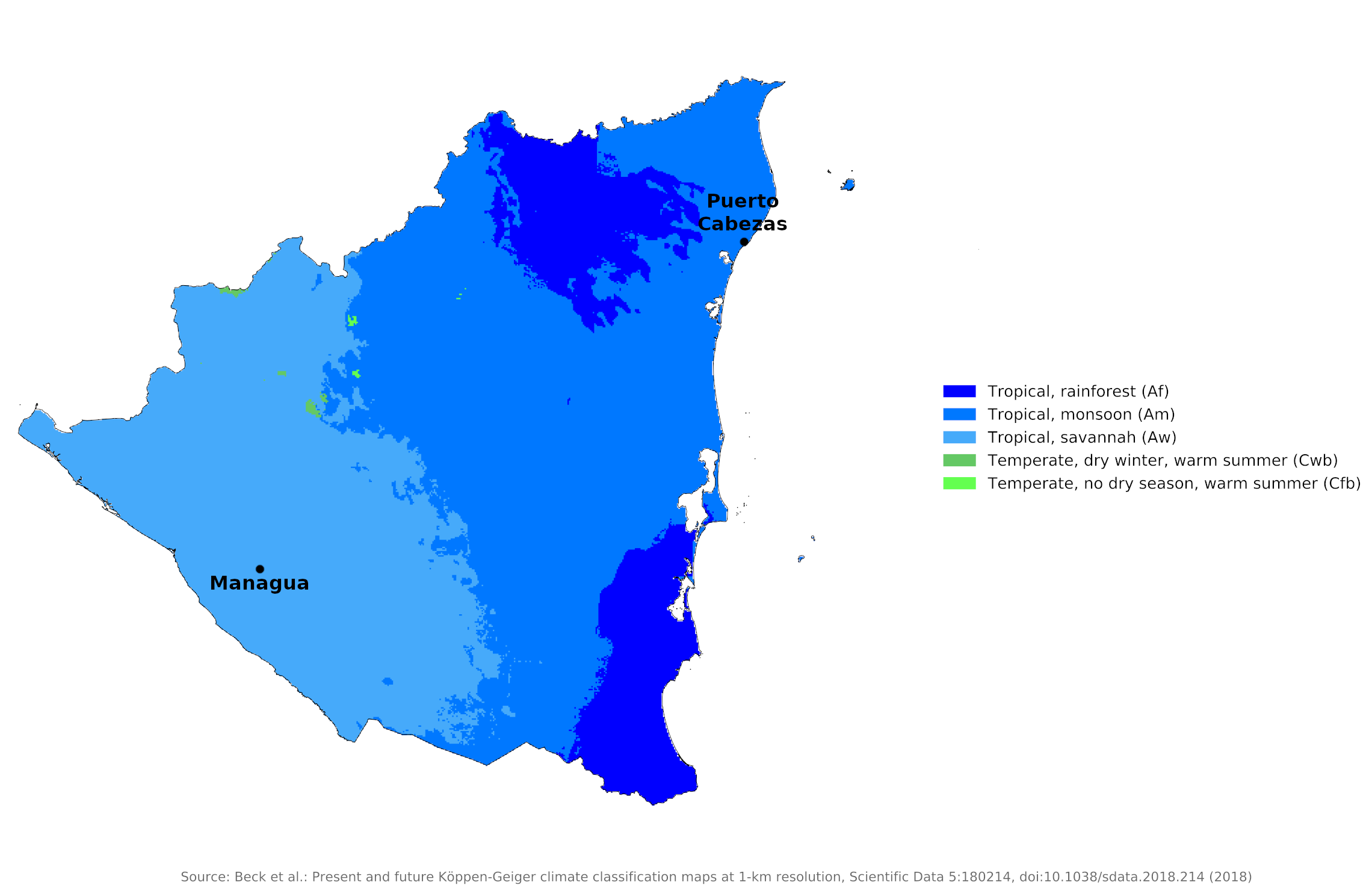 Climate map of Nicaragua
What is the climate of Nicaragua like?
Nicaragua is a country in Central America. It is located north of Costa Rica and south of Honduras, between the Pacific Ocean and the Caribbean Sea. Nicaragua is about as large as England or the state of Michigan and is situated between 11° and 15°N. It is not quite as mountainous as some countries of this region, but there are mountains rising to between 1,500 to 2,000 meters (5,000–7,000 feet). Most of the country is thus included in the two zones of the tierra caliente, the hot tropical lowland, and the tierra templada, the cooler hill region with a larger daily range of temperature.
In Nicaragua, temperature is affected more by elevation than by season. The tierra caliente, or the "hot land," is characteristic of the foothills and lowlands from sea level to about 750 meters (2,500 feet). On the flat lands (in the east and west), daytime temperatures average 29°C (85°F) and night temperatures drop below 21°C (70°F).
In the central highlands temperatures are lower. The tierra templada, or the "temperate land," is characteristic of most of the central highlands, where elevations range between 750 and 1,600 meters (2,500–5,250 feet). Temperatures are about 21°C (70°F) in the daytime and about 15°C (60°F) at night.
The tierra fria, the "cold land," at elevations above 1,600 meters (5,250 feet), is found only on and near the highest peaks of the central highlands. In these mountains, temperatures can approach freezing after dark.
Except in the central highlands, the climate is warm and humid. Average humidity in Managua in June, the most humid month, is 84%; in April, the driest month, 62%. The mean temperature, varying according to altitude, is between 20° and 30°C (68° and 86°F). In Managua, monthly average temperatures range from a minimum of 21°C (68°F) and a maximum of 31°C (88°F) in January to a minimum of 23°C (73°F) and a maximum of 31°C (88°F) in July.
There are two seasons: a wet season, from May to December, and a dry season, from January through April. Rainfall, however, varies according to region, and the rainy season in the eastern area may extend nine or even twelve months. The east coast is one of the wettest parts of Central America as a result of the easterly trade winds blowing in from the Caribbean, with an annual rainfall of between 2,300 to 5,000 millimeters (90 to 200 inches). Less rain, about 760 to 2,300 millimeters (30 to 90 inches) per year, falls on the Central Highlands; rainfall here occurs over a longer period of the year. On the Pacific Coast, annual rainfall ranges from 1,000 to 1,500 millimeters (40 to 60 inches).
During the rainy season, eastern Nicaragua experiences severe flooding along the upper and middle reaches of all major rivers. Near the coast, where river courses widen and riverbanks and natural levees are low, high water spills onto the flood plains until large parts of the lowlands become continuous bodies of water. The coast is also subject to destructive tropical storms and hurricanes, particularly from July to October. Additionally, heavy rains (known as Papagayo storms) that accompany the passage of a cold front or low-pressure system can sweep through eastern and western Nicaragua from the north from November through March.
Managua, the capital, is representative of conditions at low levels on the Pacific side of the country. Puerto Cabezas represents the eastern, Caribbean coast.
| Climate data for Managua | |||||||||||||
|---|---|---|---|---|---|---|---|---|---|---|---|---|---|
| Month | Jan | Feb | Mar | Apr | May | Jun | Jul | Aug | Sep | Oct | Nov | Dec | Year |
| Average high °C (°F) | 31.0 (87.8) | 32.1 (89.8) | 33.6 (92.5) | 34.3 (93.7) | 34.0 (93.2) | 31.4 (88.5) | 30.9 (87.6) | 31.4 (88.5) | 30.3 (86.5) | 30.8 (87.4) | 30.6 (87.1) | 30.8 (87.4) | 31.8 (89.2) |
| Daily mean °C (°F) | 26.3 (79.3) | 27.2 (81.0) | 28.5 (83.3) | 29.3 (84.7) | 29.3 (84.7) | 27.2 (81.0) | 26.8 (80.2) | 27.2 (81.0) | 26.8 (80.2) | 26.5 (79.7) | 26.3 (79.3) | 26.2 (79.2) | 27.3 (81.1) |
| Average low °C (°F) | 20.4 (68.7) | 20.6 (69.1) | 21.7 (71.1) | 22.6 (72.7) | 23.4 (74.1) | 23.0 (73.4) | 22.6 (72.7) | 22.4 (72.3) | 22.2 (72.0) | 22.1 (71.8) | 20.9 (69.6) | 20.0 (68.0) | 21.8 (71.2) |
| Average precipitation mm (inches) | 9 (0.4) | 5 (0.2) | 3 (0.1) | 8 (0.3) | 130 (5.1) | 224 (8.8) | 144 (5.7) | 136 (5.4) | 215 (8.5) | 280 (11.0) | 42 (1.7) | 8 (0.3) | 1,204 (47.4) |
| Source: Deutscher Wetterdienst | |||||||||||||
| Climate data for Puerto Cabezas | |||||||||||||
|---|---|---|---|---|---|---|---|---|---|---|---|---|---|
| Month | Jan | Feb | Mar | Apr | May | Jun | Jul | Aug | Sep | Oct | Nov | Dec | Year |
| Average high °C (°F) | 29.7 (85.5) | 29.7 (85.5) | 30.5 (86.9) | 31.3 (88.3) | 31.8 (89.2) | 31.4 (88.5) | 30.8 (87.4) | 31.2 (88.2) | 31.2 (88.2) | 31.6 (88.9) | 30.8 (87.4) | 29.7 (85.5) | 30.8 (87.5) |
| Daily mean °C (°F) | 25.0 (77.0) | 24.5 (76.1) | 26.5 (79.7) | 27.2 (81.0) | 27.8 (82.0) | 27.5 (81.5) | 27.1 (80.8) | 27.1 (80.8) | 27.0 (80.6) | 26.3 (79.3) | 25.8 (78.4) | 25.4 (77.7) | 26.4 (79.6) |
| Average low °C (°F) | 18.8 (65.8) | 18.6 (65.5) | 19.8 (67.6) | 20.9 (69.6) | 21.8 (71.2) | 22.0 (71.6) | 21.9 (71.4) | 22.0 (71.6) | 22.2 (72.0) | 21.6 (70.9) | 20.8 (69.4) | 19.3 (66.7) | 20.8 (69.4) |
| Average precipitation mm (inches) | 148 (5.8) | 83 (3.3) | 48 (1.9) | 54 (2.1) | 183 (7.2) | 378 (14.9) | 414 (16.3) | 370 (14.6) | 303 (11.9) | 338 (13.3) | 278 (10.9) | 202 (8.0) | 2,799 (110.2) |
| Source: Hong Kong Observatory | |||||||||||||
References
- E. A. Pearce, Charles Gordon Smith, (1990) The Hutchinson World Weather Guide, John Murray Press. ISBN 1859863426
- Timothy L. Gall, (ed.), (2003), Worldmark Encyclopedia of the Nations, Eleventh Edition, Thomson Gale
- Federal Research Division, Library of Congress, (1994), Nicaragua: a country study. Claitor's Pub. Division. ISBN 084440831X
- Hugh Chisholm, (ed.), (1911), Encyclopædia Britannica, Eleventh edition, Cambridge University Press
The Climate of
Nicaragua
In summary:
Nicaragua has a tropical monsoon climate. Except in the central highlands, the climate is warm and humid. Daytime temperatures average 29°C (85°F) and night temperatures drop below 21°C (70°F). In the central highlands temperatures are lower, about 21°C (70°F) in the daytime and about 15°C (60°F) at night.
The rainy season is from May through November and the dry season is from January through April. The east coast gets the greatest amount of yearly rainfall, from 2300 to 5000 mm (90 to 200 in). Less rain, about 750 to 2300 mm (30 to 90 in) per year, falls on the Central Highlands and the west coast.