The Climate of
Germany
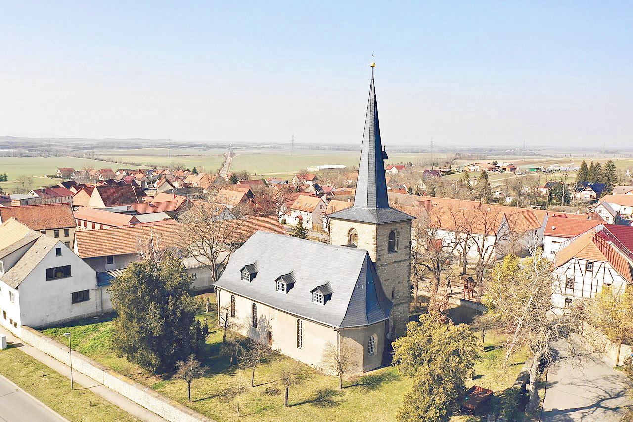 Ollendorf in the Sömmerda district of Thuringia
Climate Map
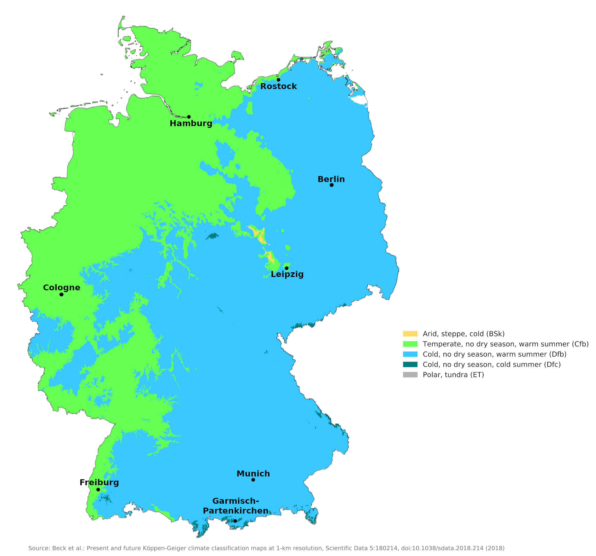 Climate map of Germany
What is the climate of Germany like?
Germany occupies a central position in Europe, it extends from Denmark in the north to Switzerland and Austria in the south. It is bordered on the west by the Benelux Countries (Belgium / Netherlands / Luxembourg) and France and on the east by Poland and the Czech Republic. It has a coastline both on the North Sea and the Baltic.
Germany's climate is moderate and is generally without sustained periods of cold or heat. Northwestern and coastal Germany have a maritime climate caused by warm westerly winds from the North Sea; the climate is characterized by warm summers and mild cloudy winters. Farther inland, the climate is continental, marked by greater variations in temperature, with warmer summers and colder winters.
Northern Germany is generally low-lying and rather flat. Central and southern Germany is hilly and rises south towards the Alps at the Austrian border. This increase in altitude towards the south of the country compensates for the more southerly degree of latitude, so that in summer the temperatures hardly differ from north to south.
In winter, the number of days with frost and snow increases both to the south and to the east, and temperatures are somewhat lower. This is a consequence of increasing distance from the sea, higher altitude and the action of cold east winds from Russia. The annual temperature range is lowest in the northwest and increases towards the south and east.
Germany sees frequent weather changes from day to day and has a fairly changeable climate. Individual summers and winters can also turn out very differently from year to year, depending on whether maritime or continental influences dominate. In harsh winters, rivers and canals can freeze over and snow can lie for a long time. Summer is slightly wetter than winter over most of the country, but in the west, autumn can be the wettest season. The summer rain is often thundery.
Annual precipitation varies from 2,000 millimeters (80 inches) a year in the southern mountains to a low of 500 millimeters (20 inches) in the vicinity of the Rhineland. Over most of the country, it averages between 600 millimeters and 800 millimeters (24 to 32 inches)per year.
For a more precise description of the weather and climate, the country can be divided into seven regions: the North Sea coast, the Baltic Sea coast, the North German Plain, North Rhineland, the central and southern hills, the Upper Rhine and the Bavarian Alps.
The Baltic Coast
Including Schleswig-Holstein (Kiel), Mecklenburg-West Pomerania (Rostock).
The Baltic Sea coast includes the east coast of Schleswig-Holstein and the north coast of Mecklenburg-West Pomerania. It has a harsher winter than the North Sea coast, especially during winters when there is a lot of sea ice in the Baltic Sea. Summers tend to be more settled than on the North Sea coast, with more sunshine, but thunderstorms are more common. See the example of Rostock.
| Climate data for Rostock (1981–2010) | |||||||||||||
|---|---|---|---|---|---|---|---|---|---|---|---|---|---|
| Month | Jan | Feb | Mar | Apr | May | Jun | Jul | Aug | Sep | Oct | Nov | Dec | Year |
| Average high °C (°F) | 3.4 (38.1) | 3.9 (39.0) | 7.1 (44.8) | 11.6 (52.9) | 16.3 (61.3) | 18.1 (64.6) | 21.8 (71.2) | 21.7 (71.1) | 18.0 (64.4) | 13.1 (55.6) | 7.7 (45.9) | 4.2 (39.6) | 12.4 (54.3) |
| Daily mean °C (°F) | 1.4 (34.5) | 1.7 (35.1) | 4.3 (39.7) | 8.2 (46.8) | 12.5 (54.5) | 15.6 (60.1) | 18.3 (64.9) | 18.2 (64.8) | 14.8 (58.6) | 10.3 (50.5) | 5.6 (42.1) | 2.3 (36.1) | 9.5 (49.1) |
| Average low °C (°F) | −0.7 (30.7) | −0.4 (31.3) | 1.6 (34.9) | 4.7 (40.5) | 8.8 (47.8) | 12.2 (54.0) | 14.6 (58.3) | 14.6 (58.3) | 11.6 (52.9) | 7.5 (45.5) | 3.4 (38.1) | 0.3 (32.5) | 6.6 (43.9) |
| Average precipitation mm (inches) | 47.6 (1.87) | 36.5 (1.44) | 41.5 (1.63) | 34.8 (1.37) | 52.9 (2.08) | 70.2 (2.76) | 62.2 (2.45) | 67.1 (2.64) | 60.0 (2.36) | 45.5 (1.79) | 49.1 (1.93) | 48.9 (1.93) | 616.3 (24.26) |
| Source: Météo Climat | |||||||||||||
The North German Plain
Including North Rhine-Westphalia (Düsseldorf), Niedersachsen (Hanover), Saxony-Anhalt (Magdeburg), Brandenburg (Berlin).
The North German Plain is the low-lying, gently rolling region that is itself a western extension of the great North European Plain. From the Dutch border to Poland there is not much difference in climate or weather, except heading east the winters get colder and the summers more settled and a little warmer. During severe cold snaps in winter, canals and navigable rivers can freeze over. Such cold spells occur when easterly winds blow from Russia. In some winters, however, such periods are short and rare. Summers are generally more settled than in the northern coastal regions. Although summer is the wettest season, rain is often thundery and short-lived, so summer sunshine amounts are moderately high. See the example of Berlin.
| Climate data for Berlin (1981–2010) | |||||||||||||
|---|---|---|---|---|---|---|---|---|---|---|---|---|---|
| Month | Jan | Feb | Mar | Apr | May | Jun | Jul | Aug | Sep | Oct | Nov | Dec | Year |
| Average high °C (°F) | 2.8 (37.0) | 4.3 (39.7) | 8.7 (47.7) | 14.3 (57.7) | 19.4 (66.9) | 22.0 (71.6) | 24.6 (76.3) | 24.2 (75.6) | 19.3 (66.7) | 13.8 (56.8) | 7.3 (45.1) | 3.3 (37.9) | 13.7 (56.7) |
| Daily mean °C (°F) | 0.1 (32.2) | 0.9 (33.6) | 4.3 (39.7) | 9.0 (48.2) | 14.0 (57.2) | 16.8 (62.2) | 19.1 (66.4) | 18.5 (65.3) | 14.2 (57.6) | 9.4 (48.9) | 4.4 (39.9) | 1.0 (33.8) | 9.3 (48.7) |
| Average low °C (°F) | −2.8 (27.0) | −2.4 (27.7) | 0.4 (32.7) | 3.5 (38.3) | 8.2 (46.8) | 11.2 (52.2) | 13.5 (56.3) | 13.0 (55.4) | 9.6 (49.3) | 5.4 (41.7) | 1.4 (34.5) | −1.6 (29.1) | 5.0 (41.0) |
| Average precipitation mm (inches) | 37.2 (1.46) | 30.1 (1.19) | 39.3 (1.55) | 33.7 (1.33) | 52.6 (2.07) | 60.2 (2.37) | 52.5 (2.07) | 53.0 (2.09) | 39.5 (1.56) | 32.2 (1.27) | 37.8 (1.49) | 46.1 (1.81) | 515.2 (20.28) |
| Source: Deutscher Wetterdienst | |||||||||||||
The Central and Southern Hills
Including Bavaria (Munich, Nuremburg, Rothenburg), Hessen (Kassel), West Saxony (Leipzig), Saxony (Dresden), Baden-Württemburg (Stuttgart), Saarland (Saarbrücken).
The Central and Southern region includes all the higher ground south of the North German Plain to the Bavarian foothills of the Alps and the hills west of the Rhine Gorge. As Leipzig and Munich show, there are no major weather and climate differences in this extensive region. Temperature varies mainly due to altitude, so the higher parts of Bavaria and the Harz Mountains have colder winters and longer durations of snow cover. Summers are generally warm with plenty of sunshine, despite heavier summer rainfall. Despite the lower altitude, severe frosts can occur in some valleys in winter. As with much of Central Europe, summers vary from year to year, some being warm and dry, others cloudy and wet.
| Climate data for Leipzig (1981–2010) | |||||||||||||
|---|---|---|---|---|---|---|---|---|---|---|---|---|---|
| Month | Jan | Feb | Mar | Apr | May | Jun | Jul | Aug | Sep | Oct | Nov | Dec | Year |
| Average high °C (°F) | 3.2 (37.8) | 4.3 (39.7) | 8.7 (47.7) | 13.9 (57.0) | 19.0 (66.2) | 21.7 (71.1) | 24.5 (76.1) | 24.1 (75.4) | 19.3 (66.7) | 14.0 (57.2) | 7.6 (45.7) | 3.6 (38.5) | 13.67 (56.61) |
| Daily mean °C (°F) | 0.5 (32.9) | 1.1 (34.0) | 4.7 (40.5) | 8.9 (48.0) | 13.8 (56.8) | 16.5 (61.7) | 19.0 (66.2) | 18.6 (65.5) | 14.4 (57.9) | 9.8 (49.6) | 4.7 (40.5) | 1.3 (34.3) | 9.45 (49.01) |
| Average low °C (°F) | −2.2 (28.0) | −2.0 (28.4) | 1.1 (34.0) | 4.1 (39.4) | 8.5 (47.3) | 11.5 (52.7) | 13.8 (56.8) | 13.6 (56.5) | 10.1 (50.2) | 6.2 (43.2) | 2.0 (35.6) | −1.2 (29.8) | 5.47 (41.85) |
| Average precipitation mm (inches) | 31.9 (1.26) | 26.3 (1.04) | 38.8 (1.53) | 39.6 (1.56) | 46.9 (1.85) | 54.8 (2.16) | 68.9 (2.71) | 63.1 (2.48) | 49.9 (1.96) | 31.0 (1.22) | 43.4 (1.71) | 39.8 (1.57) | 534.1 (21.0) |
| Source: Deutscher Wetterdienst | |||||||||||||
| Climate data for Munich (1981–2010) | |||||||||||||
|---|---|---|---|---|---|---|---|---|---|---|---|---|---|
| Month | Jan | Feb | Mar | Apr | May | Jun | Jul | Aug | Sep | Oct | Nov | Dec | Year |
| Average high °C (°F) | 3.5 (38.3) | 5.0 (41.0) | 9.5 (49.1) | 14.2 (57.6) | 19.1 (66.4) | 21.9 (71.4) | 24.4 (75.9) | 23.9 (75.0) | 19.4 (66.9) | 14.3 (57.7) | 7.7 (45.9) | 4.2 (39.6) | 13.9 (57.0) |
| Daily mean °C (°F) | 0.3 (32.5) | 1.4 (34.5) | 5.3 (41.5) | 9.4 (48.9) | 14.3 (57.7) | 17.2 (63.0) | 19.4 (66.9) | 18.9 (66.0) | 14.7 (58.5) | 10.1 (50.2) | 4.4 (39.9) | 1.3 (34.3) | 9.7 (49.5) |
| Average low °C (°F) | −2.5 (27.5) | −1.9 (28.6) | 1.6 (34.9) | 4.9 (40.8) | 9.4 (48.9) | 12.5 (54.5) | 14.5 (58.1) | 14.2 (57.6) | 10.5 (50.9) | 6.6 (43.9) | 1.7 (35.1) | −1.2 (29.8) | 5.9 (42.6) |
| Average precipitation mm (inches) | 48 (1.9) | 46 (1.8) | 65 (2.6) | 65 (2.6) | 101 (4.0) | 118 (4.6) | 122 (4.8) | 115 (4.5) | 75 (3.0) | 65 (2.6) | 61 (2.4) | 65 (2.6) | 944 (37.2) |
| Source: Deutscher Wetterdienst | |||||||||||||
The Northwest Coastlands
Including Hamburg and Bremen.
The Northwest Coast includes the coast from the mouth of the Ems to the Elbe, the East Frisian Islands and the west coast of Schleswig-Holstein. This is the mildest area of Germany in winter, but the weather can still be cold when easterly winds prevail. Summer is usually the wettest season. Weather can be variable throughout all seasons and the region can be subject to Atlantic storms. The average daily sunshine duration ranges from about two hours in winter to six in summer. Conditions are represented by that for Hamburg.
| Climate data for Hamburg (1981-2010) | |||||||||||||
|---|---|---|---|---|---|---|---|---|---|---|---|---|---|
| Month | Jan | Feb | Mar | Apr | May | Jun | Jul | Aug | Sep | Oct | Nov | Dec | Year |
| Average high °C (°F) | 3.5 (38.3) | 4.4 (39.9) | 8.0 (46.4) | 12.3 (54.1) | 17.5 (63.5) | 19.9 (67.8) | 22.1 (71.8) | 22.2 (72.0) | 17.9 (64.2) | 13.0 (55.4) | 7.5 (45.5) | 4.6 (40.3) | 13.2 (55.8) |
| Daily mean °C (°F) | 1.0 (33.8) | 1.6 (34.9) | 4.6 (40.3) | 7.8 (46.0) | 12.5 (54.5) | 15.2 (59.4) | 17.4 (63.3) | 17.4 (63.3) | 13.7 (56.7) | 9.5 (49.1) | 4.9 (40.8) | 2.3 (36.1) | 9.0 (48.2) |
| Average low °C (°F) | −1.4 (29.5) | −1.2 (29.8) | 1.1 (34.0) | 3.3 (37.9) | 7.4 (45.3) | 10.5 (50.9) | 12.7 (54.9) | 12.5 (54.5) | 9.6 (49.3) | 6.0 (42.8) | 2.4 (36.3) | 0.0 (32.0) | 6.2 (43.2) |
| Average precipitation mm (inches) | 67.8 (2.67) | 49.9 (1.96) | 67.7 (2.67) | 43.0 (1.69) | 57.4 (2.26) | 78.6 (3.09) | 76.7 (3.02) | 78.9 (3.11) | 67.4 (2.65) | 67.0 (2.64) | 69.2 (2.72) | 68.9 (2.71) | 792.6 (31.20) |
| Source: World Meteorological Organization | |||||||||||||
The North Rhineland
Including North Rhine-Westphalia (Cologne, Bonn, Essen), Hessen (Frankfurt-am-Main).
This northwestern district of Germany includes the Ruhr industrial area and the gorge section of the Rhine Valley from Mannheim to Bonn. On both sides of the Rhine gorge there are uplands such as the Eifel and the Westerwald, where the climate is similar to that of the central and southern hills. Cologne is representative of the lowlands of this region, in which many large and important cities are located. The hillsides along the Rhine and Moselle valleys have a climate suitable for viticulture. Winters can be quite cold and summer weather is often unsettled and changeable, but generally warm enough and sunny enough to make this a wine country of note.
| Climate data for Cologne (1991–2020) | |||||||||||||
|---|---|---|---|---|---|---|---|---|---|---|---|---|---|
| Month | Jan | Feb | Mar | Apr | May | Jun | Jul | Aug | Sep | Oct | Nov | Dec | Year |
| Average high °C (°F) | 5.9 (42.6) | 7.2 (45.0) | 11.4 (52.5) | 16.1 (61.0) | 19.7 (67.5) | 22.7 (72.9) | 24.9 (76.8) | 24.5 (76.1) | 20.4 (68.7) | 15.2 (59.4) | 9.8 (49.6) | 6.5 (43.7) | 15.4 (59.7) |
| Daily mean °C (°F) | 3.0 (37.4) | 3.6 (38.5) | 6.7 (44.1) | 10.4 (50.7) | 14.1 (57.4) | 17.1 (62.8) | 19.0 (66.2) | 18.5 (65.3) | 14.8 (58.6) | 10.8 (51.4) | 6.7 (44.1) | 3.8 (38.8) | 10.7 (51.3) |
| Average low °C (°F) | 0.0 (32.0) | 0.1 (32.2) | 2.0 (35.6) | 4.5 (40.1) | 8.1 (46.6) | 11.2 (52.2) | 13.3 (55.9) | 12.8 (55.0) | 9.7 (49.5) | 6.8 (44.2) | 3.5 (38.3) | 1.0 (33.8) | 6.1 (42.9) |
| Average precipitation mm (inches) | 61.7 (2.43) | 53.8 (2.12) | 55.0 (2.17) | 48.2 (1.90) | 62.1 (2.44) | 86.3 (3.40) | 87.4 (3.44) | 83.3 (3.28) | 66.9 (2.63) | 64.7 (2.55) | 63.5 (2.50) | 69.2 (2.72) | 802.1 (31.58) |
| Source: Deutscher Wetterdienst | |||||||||||||
The Upper Rhine Valley
Including southwestern Baden-Württemburg, the Black Forest (Freiburg-im-Breisgau, Baden- Baden, Heidelberg).
This small part of southwest Germany includes the German part of the Upper Rhine Valley up to the Swiss border. In spring and summer it is the warmest part of the country and produces a wide variety of crops including grapes. It is a sunny region in summer with up to eight hours of sunshine per day. However, winters can be quite cold due to the short distance to the Alps and long distance to the sea. See Freiburg im Breisgau.
| Climate data for Freiburg (2015–2020) | |||||||||||||
|---|---|---|---|---|---|---|---|---|---|---|---|---|---|
| Month | Jan | Feb | Mar | Apr | May | Jun | Jul | Aug | Sep | Oct | Nov | Dec | Year |
| Average high °C (°F) | 5.7 (42.3) | 7.9 (46.2) | 12.6 (54.7) | 16.7 (62.1) | 20.3 (68.5) | 25.0 (77.0) | 27.8 (82.0) | 27.5 (81.5) | 22.3 (72.1) | 16.2 (61.2) | 10.2 (50.4) | 7.9 (46.2) | 16.7 (62.1) |
| Daily mean °C (°F) | 2.8 (37.0) | 4.0 (39.2) | 7.2 (45.0) | 10.6 (51.1) | 14.5 (58.1) | 19.0 (66.2) | 21.3 (70.3) | 21.0 (69.8) | 16.1 (61.0) | 11.4 (52.5) | 6.7 (44.1) | 4.6 (40.3) | 11.6 (52.9) |
| Average low °C (°F) | 0.0 (32.0) | 0.1 (32.2) | 1.9 (35.4) | 4.6 (40.3) | 8.8 (47.8) | 13.8 (56.8) | 14.8 (58.6) | 14.4 (57.9) | 10.0 (50.0) | 6.6 (43.9) | 3.1 (37.6) | 1.3 (34.3) | 6.6 (43.9) |
| Average precipitation> mm (inches) | 44.5 (1.75) | 42.9 (1.69) | 36.7 (1.44) | 77 (3.0) | 96.2 (3.79) | 76.3 (3.00) | 52.5 (2.07) | 53.4 (2.10) | 45.4 (1.79) | 49.0 (1.93) | 66.2 (2.61) | 35.9 (1.41) | 676.1 (26.62) |
| Source: Weatheronline.de | |||||||||||||
The Bavarian Alps
Including the southernmost part of Bavaria (Oberammergau, Berchtesgaden).
The German Alps stretch along the border of the Austrian Tyrol. Here are the highest mountains in Germany and this is a popular winter sports area. This region also has a number of lake resorts that are popular in summer. Winters are cold and snowy, but summers are moderately warm, although fairly wet. See the example of Garmisch-Partenkirchen.
| Climate data for Garmisch-Partenkirchen | |||||||||||||
|---|---|---|---|---|---|---|---|---|---|---|---|---|---|
| Month | Jan | Feb | Mar | Apr | May | Jun | Jul | Aug | Sep | Oct | Nov | Dec | Year |
| Average high °C (°F) | 2 (36) | 4 (39) | 8 (46) | 12 (54) | 17 (63) | 19 (66) | 21 (70) | 21 (70) | 18 (64) | 13 (55) | 7 (45) | 2 (36) | 12 (54) |
| Daily mean °C (°F) | −2 (28) | 0 (32) | 3 (37) | 6 (43) | 11 (52) | 13 (55) | 15 (59) | 15 (59) | 12 (54) | 8 (46) | 3 (37) | −1 (30) | 7 (45) |
| Average low °C (°F) | −6 (21) | −5 (23) | −2 (28) | 1 (34) | 5 (41) | 8 (46) | 10 (50) | 10 (50) | 7 (45) | 3 (37) | −1 (30) | −5 (23) | 2 (36) |
| Average precipitation mm (inches) | 70 (2.8) | 50 (2.0) | 60 (2.4) | 90 (3.5) | 120 (4.7) | 170 (6.7) | 180 (7.1) | 160 (6.3) | 120 (4.7) | 70 (2.8) | 60 (2.4) | 80 (3.1) | 1,280 (50.4) |
| Source: Weatherbase.com | |||||||||||||
When is the best time to visit Germany?
Germany has sunny summers often lasting through October. Winters are generally cold, especially in the Alpine districts. January is the coldest month. Best time to visit is April-September.
References
- E. A. Pearce, Charles Gordon Smith, (1990) The Hutchinson World Weather Guide, John Murray Press. ISBN 1859863426
- Timothy L. Gall, (ed.), (2003), Worldmark Encyclopedia of the Nations, Eleventh Edition, Thomson Gale
- Federal Research Division, Library of Congress, (1996), Germany: a country study. Claitor's Pub. Division. ISBN 0844408530
- Hugh Chisholm, (ed.), (1911), Encyclopædia Britannica, Eleventh edition, Cambridge University Press
The Climate of
Germany
In summary:
Germany has a temperate and maritime climate. The Gulf Stream westerly winds from the North Sea moderate temperatures throughout the year. In the lowlands, mid-winter temperatures average more than 1.6°C (35°F), while summer temperatures average between 16° and 18°C (61° and 64°F). In the south, temperatures are somewhat more extreme, averaging about -2°C (28°F) in winter and 19.4°C (67°F) or higher in summer.
Rainfall varies from 500 millimeters (20 inches) to 2000 millimeters (79 inches) in the Alps. The national yearly average is between 600 and 800 millimeters (24 and 31.5 inches).