The Climate of
Morocco
.jpg) Royal Palace gateway in Rabat
Royal Palace gateway in Rabat
.jpg&oldid=507397007)
Climate Map
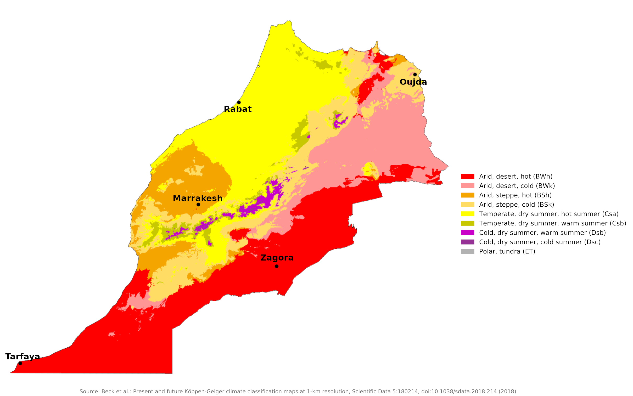 Climate map of Morocco
What is the climate of Morocco like?
Morocco is a slightly smaller country than France, occupying the northwest corner of Africa. With a coastline on both the Atlantic and the Mediterranean, it dominates the south coast of the narrow Strait of Gibraltar. There is a narrow coastal belt with a typical Mediterranean climate; an interior region of high mountains and plateaus; and a southern edge at the edge of the Sahara desert. Morocco shares a long eastern border with Algeria and has a territorial claim to Western Sahara to the south.
Morocco has two climate zones: coastal and inland. The temperature fluctuations are relatively small along the Atlantic coast, while the interior is characterized by extreme fluctuations. Deflecting the humid Atlantic winds, the eastern slopes of the Atlas Mountains have a severe sub-Saharan climate, while the western slopes are relatively cool and well-watered.
Morocco's north coast and inland mountains, the Rif, have a Mediterranean climate. The rainy season is from October to April. Northwest Morocco, particularly the Rif Mountains, is exposed to Atlantic depressions in winter and moderately heavy rainfall. The Atlantic coast as far south as Agadir receives over 200 millimeters (8 inches) of rain in winter, but further south the climate becomes progressively drier and the Sahara extends to the coast. Rainfall increases to over 400 millimeters (16 inches) north of Casablanca.
Daily hours of sunshine on the Atlantic coast average nine to ten, compared to up to twelve hours inland in the desert. The clouds in the Atlas Mountains also reduce the summer sun to some extent. In winter, sunshine hours range from five to six a day in the north to eight or more in the south.
The sea and air temperatures on the Atlantic coast are kept lower than on the Mediterranean coast by the cool waters of the Canaries Current. Along this coast, summer temperatures are significantly cooler than inland and the cold offshore waters cause some cloud and fog in summer. Winters on the Atlantic coast are very mild and snow is unknown. In the spring and fall, precipitation is slight and irregular. The coast in general has a more stable climate than the interior, and particularly around Casablanca it is fresher and less humid than on the Mediterranean. Rabat illustrates conditions on this coast, while Oujda illustrates conditions in the drier northeast.
| Climate data for Rabat | |||||||||||||
|---|---|---|---|---|---|---|---|---|---|---|---|---|---|
| Month | Jan | Feb | Mar | Apr | May | Jun | Jul | Aug | Sep | Oct | Nov | Dec | Year |
| Average high °C (°F) | 17.2 (63.0) | 17.7 (63.9) | 19.2 (66.6) | 20.0 (68.0) | 22.1 (71.8) | 24.1 (75.4) | 26.8 (80.2) | 27.1 (80.8) | 26.4 (79.5) | 24.0 (75.2) | 20.6 (69.1) | 17.7 (63.9) | 21.9 (71.4) |
| Daily mean °C (°F) | 12.6 (54.7) | 13.1 (55.6) | 14.2 (57.6) | 15.2 (59.4) | 17.4 (63.3) | 19.8 (67.6) | 22.2 (72.0) | 22.4 (72.3) | 21.5 (70.7) | 19.0 (66.2) | 15.9 (60.6) | 13.2 (55.8) | 17.2 (63.0) |
| Average low °C (°F) | 8.0 (46.4) | 8.6 (47.5) | 9.2 (48.6) | 10.4 (50.7) | 12.7 (54.9) | 15.4 (59.7) | 17.6 (63.7) | 17.7 (63.9) | 16.7 (62.1) | 14.1 (57.4) | 11.1 (52.0) | 8.7 (47.7) | 12.5 (54.5) |
| Average precipitation mm (inches) | 77.2 (3.04) | 74.1 (2.92) | 60.9 (2.40) | 62.0 (2.44) | 25.3 (1.00) | 6.7 (0.26) | 0.5 (0.02) | 1.3 (0.05) | 5.7 (0.22) | 43.6 (1.72) | 96.7 (3.81) | 100.9 (3.97) | 554.9 (21.85) |
| Source: NOAA | |||||||||||||
| Climate data for Oujda (1981–2010) | |||||||||||||
|---|---|---|---|---|---|---|---|---|---|---|---|---|---|
| Month | Jan | Feb | Mar | Apr | May | Jun | Jul | Aug | Sep | Oct | Nov | Dec | Year |
| Average high °C (°F) | 16.0 (60.8) | 17.4 (63.3) | 19.9 (67.8) | 21.7 (71.1) | 24.9 (76.8) | 29.7 (85.5) | 33.7 (92.7) | 34.0 (93.2) | 30.1 (86.2) | 25.7 (78.3) | 20.3 (68.5) | 17.1 (62.8) | 24.2 (75.6) |
| Daily mean °C (°F) | 9.9 (49.8) | 11.2 (52.2) | 13.2 (55.8) | 14.9 (58.8) | 18.0 (64.4) | 22.3 (72.1) | 25.9 (78.6) | 26.3 (79.3) | 23.0 (73.4) | 19.1 (66.4) | 14.4 (57.9) | 11.3 (52.3) | 17.5 (63.5) |
| Average low °C (°F) | 3.8 (38.8) | 5.0 (41.0) | 6.6 (43.9) | 8.1 (46.6) | 11.1 (52.0) | 15.0 (59.0) | 18.0 (64.4) | 18.6 (65.5) | 16.0 (60.8) | 12.4 (54.3) | 8.5 (47.3) | 5.6 (42.1) | 10.7 (51.3) |
| Average precipitation mm (inches) | 29.0 (1.14) | 30.0 (1.18) | 35.0 (1.38) | 28.9 (1.14) | 25.5 (1.00) | 7.2 (0.28) | 1.9 (0.07) | 5.1 (0.20) | 16.9 (0.67) | 24.5 (0.96) | 34.6 (1.36) | 23.4 (0.92) | 261.9 (10.31) |
| Source: World Meteorological Organization | |||||||||||||
Inland in the High Atlas Mountains, weather and climate are heavily influenced by altitude. The Atlas Mountains are at their finest here, with the highest point rising to 4,163 meters (13,655 feet). The mountains act as barriers between the western and eastern parts of the country. In winter the westerly winds off the Atlantic bring snow and rain that fall on the western flanks of the mountains, leaving little for the eastern steppes and plains. Winter snowfall can be heavy and the highest areas remain snow-covered well into summer.
In the lower inland areas, summers are very hot, while in winter and spring, winds blowing off the mountains can cause some very cool days. At medium altitudes, Morocco's climate is very pleasant all year round. Summers are hot but humidity is fairly low, while winters are generally mild and sunny, despite some periods of changeable weather (see Marrakech's climate).
| Climate data for Marrakesh (1981–2010) | |||||||||||||
|---|---|---|---|---|---|---|---|---|---|---|---|---|---|
| Month | Jan | Feb | Mar | Apr | May | Jun | Jul | Aug | Sep | Oct | Nov | Dec | Year |
| Average high °C (°F) | 18.6 (65.5) | 20.5 (68.9) | 23.5 (74.3) | 25.0 (77.0) | 28.3 (82.9) | 32.8 (91.0) | 37.2 (99.0) | 36.6 (97.9) | 32.5 (90.5) | 27.9 (82.2) | 22.9 (73.2) | 19.6 (67.3) | 27.1 (80.8) |
| Daily mean °C (°F) | 12.2 (54.0) | 14.2 (57.6) | 17.0 (62.6) | 18.4 (65.1) | 21.3 (70.3) | 25.1 (77.2) | 28.9 (84.0) | 28.6 (83.5) | 25.6 (78.1) | 21.6 (70.9) | 16.8 (62.2) | 13.5 (56.3) | 20.3 (68.5) |
| Average low °C (°F) | 5.8 (42.4) | 8.0 (46.4) | 10.4 (50.7) | 11.9 (53.4) | 14.4 (57.9) | 17.5 (63.5) | 20.5 (68.9) | 20.6 (69.1) | 18.7 (65.7) | 15.3 (59.5) | 10.7 (51.3) | 7.3 (45.1) | 13.4 (56.1) |
| Average precipitation mm (inches) | 29.5 (1.16) | 29.6 (1.17) | 36.6 (1.44) | 24.4 (0.96) | 10.5 (0.41) | 4.0 (0.16) | 2.3 (0.09) | 2.7 (0.11) | 9.7 (0.38) | 17.5 (0.69) | 28.7 (1.13) | 24.6 (0.97) | 220.3 (8.67) |
| Source: World Meteorological Organization | |||||||||||||
The climate of the Sahara region in Morocco is similar to that of Algeria with very hot summers and little rain. (See the climate of Zagora). In the south, however, where the desert reaches the coast, summer temperatures are tempered by cool ocean waters and sustained daytime sea breezes. Winter temperatures are also milder here than inland. (See the climate of Tarfaya).
| Climate data for Zagora | |||||||||||||
|---|---|---|---|---|---|---|---|---|---|---|---|---|---|
| Month | Jan | Feb | Mar | Apr | May | Jun | Jul | Aug | Sep | Oct | Nov | Dec | Year |
| Average high °C (°F) | 20.3 (68.5) | 22.4 (72.3) | 26.0 (78.8) | 30.7 (87.3) | 35.5 (95.9) | 40.8 (105.4) | 44.9 (112.8) | 43.5 (110.3) | 36.7 (98.1) | 30.8 (87.4) | 25.2 (77.4) | 20.4 (68.7) | 31.4 (88.6) |
| Daily mean °C (°F) | 12.1 (53.8) | 14.2 (57.6) | 17.8 (64.0) | 21.9 (71.4) | 26.3 (79.3) | 31.1 (88.0) | 35.0 (95.0) | 34.3 (93.7) | 28.3 (82.9) | 23.0 (73.4) | 17.9 (64.2) | 13.0 (55.4) | 22.9 (73.2) |
| Average low °C (°F) | 3.8 (38.8) | 5.9 (42.6) | 9.6 (49.3) | 13.1 (55.6) | 17.1 (62.8) | 21.4 (70.5) | 25.1 (77.2) | 25.0 (77.0) | 19.9 (67.8) | 15.1 (59.2) | 10.6 (51.1) | 5.5 (41.9) | 14.3 (57.8) |
| Average precipitation mm (inches) | 4 (0.2) | 3 (0.1) | 5 (0.2) | 1 (0.0) | 2 (0.1) | 1 (0.0) | 1 (0.0) | 3 (0.1) | 6 (0.2) | 13 (0.5) | 15 (0.6) | 7 (0.3) | 61 (2.4) |
| Source: Climate-data.org | |||||||||||||
| Climate data for Tarfaya | |||||||||||||
|---|---|---|---|---|---|---|---|---|---|---|---|---|---|
| Month | Jan | Feb | Mar | Apr | May | Jun | Jul | Aug | Sep | Oct | Nov | Dec | Year |
| Average high °C (°F) | 19 (66) | 19 (66) | 20 (68) | 21 (70) | 21 (70) | 22 (72) | 22 (72) | 23 (73) | 23 (73) | 23 (73) | 22 (72) | 20 (68) | 21 (70) |
| Daily mean °C (°F) | 16 (61) | 16 (61) | 17 (63) | 18 (64) | 18.5 (65.3) | 19.5 (67.1) | 20 (68) | 20.5 (68.9) | 20.5 (68.9) | 20 (68) | 19 (66) | 16.5 (61.7) | 18.5 (65.2) |
| Average low °C (°F) | 13 (55) | 13 (55) | 14 (57) | 15 (59) | 16 (61) | 17 (63) | 18 (64) | 18 (64) | 18 (64) | 17 (63) | 16 (61) | 13 (55) | 16 (60) |
| Average precipitation mm (inches) | 0 (0) | 0 (0) | 0 (0) | 0 (0) | 0 (0) | 0 (0) | 0 (0) | 0 (0) | 0 (0) | 0 (0) | 10 (0.4) | 0 (0) | 10 (0.4) |
| Source: Weather Atlas | |||||||||||||
References
- E. A. Pearce, Charles Gordon Smith, (1990) The Hutchinson World Weather Guide, John Murray Press. ISBN 1859863426
- Timothy L. Gall, (ed.), (2003), Worldmark Encyclopedia of the Nations, Eleventh Edition, Thomson Gale
- Federal Research Division, Library of Congress, (1985), Morocco: a country study. Claitor's Pub. Division.
- Hugh Chisholm, (ed.), (1911), Encyclopædia Britannica, Eleventh edition, Cambridge University Press
The Climate of
Morocco
In summary:
Morocco has two climatic zones: coastal and interior. The north and central areas have a Mediterranean climate, moderate and subtropical, cooled by the Mediterranean Sea and Atlantic Ocean. These areas characteristically have warm, wet winters and hot, dry summers. The eastern slopes of the Atlas Mountains, which divert the moisture-laden Atlantic winds, have a rigorous pre-Saharan climate characterized by extreme variation in temperature.
A maximum annual rainfall of 750 to 1000 mm (30 to 40 in) occurs in the northwest. Other parts of the country receive much less rain.