The Climate of
Venezuela
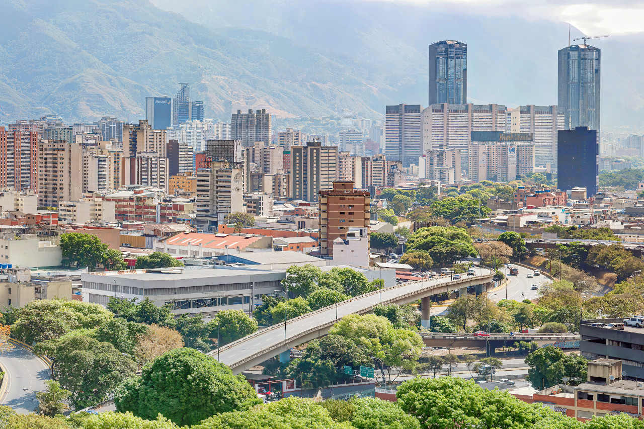 Panoramic view of Caracas
Climate Map
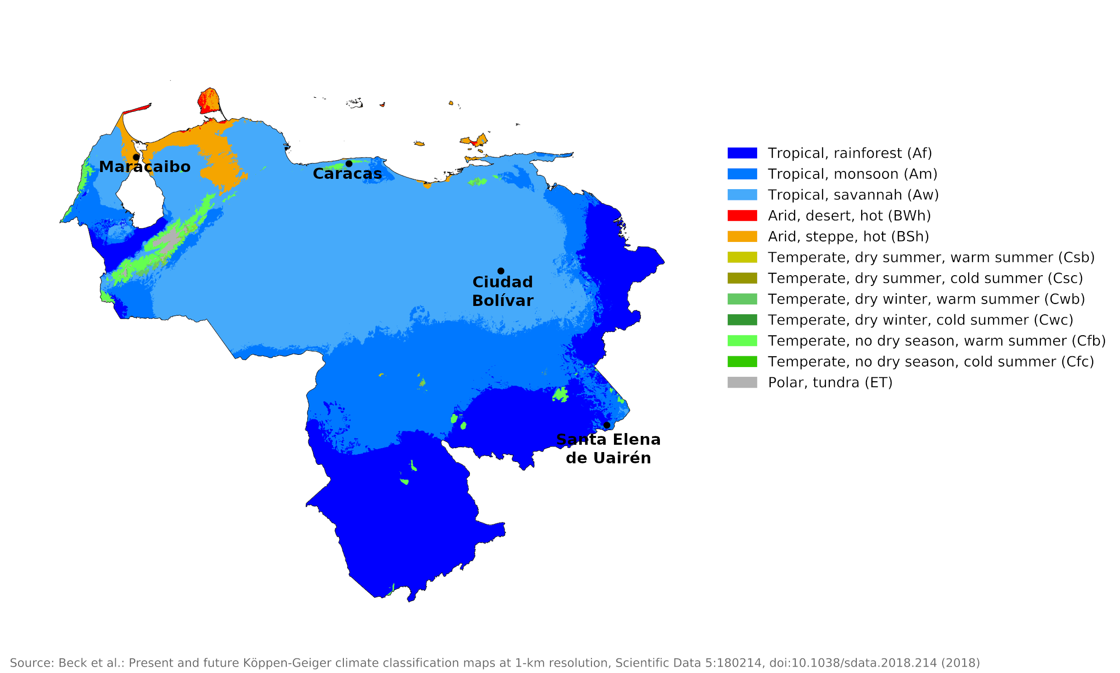 Climate map of Venezuela
What is the climate of Venezuela like?
Venezuela is the northernmost country in South America and lies between 1° and 12°N. It's a little over twice the size of France or the state of Texas. It has a long coastline on the Caribbean Sea and is bordered on the west by Colombia, on the east by Guyana, and on the south by Brazil.
In Venezuela, the main chain of the Andes runs west to east, leaving a narrow coastal plain on the Caribbean coast. To the west there is a more extensive swampy lowland around Lake Maracaibo. South of the Andes, in the valley of the Orinoco River, extends a large lowland area known as the Llanos; this has a typical tropical climate with a single rainy season. In the southeast of the country, the country rises to a plateau that extends into Guyana, with an average elevation of about 600 meters (2,000 feet); numerous hills rise above 1,800 meters (6,000 feet) from this plateau. The Andes in Venezuela are lower and narrower than in Colombia, Peru and Bolivia, but there are a number of individual peaks that tower over 4,600 meters (15,000 feet) and carry snow all year round. Due to the high altitude, there are many local weather and climate variations.
Although the country is entirely in the tropics, its climate varies from tropical humid to alpine depending on elevation, topography, and the direction and intensity of prevailing winds. Seasons are determined less by temperature than by rainfall. Most of the country has a distinct rainy season; the rainy season (May to November) is commonly referred to as winter and the rest of the year as summer.
The country falls into four horizontal temperature zones based primarily on altitude. In the tropical region, including the cities of Maracaibo and Ciudad Bolívar, average annual temperatures range from 24°C to 35°C (75°F to 95°F). In the subtropical region where Caracas is located, average temperatures range from 10° to 25°C (50° to 77°F). At elevations between 2,000 and 3,000 meters (6,560 to 9,840 feet), temperatures average between 9°C and 11°C (48°F to 52°F). In the high mountains above 3,000 meters (9,840 feet) there are permanent snowfields and the average annual temperature is below 8°C (46°F).
Venezuela is unusual among South American countries in that the main rainy season is almost everywhere from April to October at the time of the high sun. In the west of the country there is a tendency towards a double rainy season, as in Colombia. The northern lowlands, particularly to the west, have a surprisingly dry climate for a tropical coast. This is believed to be a consequence of the direction of the coast in relation to the frequent northeast trade winds.
The northern slopes of the Andes generally have less rainfall than the southern slopes. Caracas, at an elevation of 1,040 meters (3,400 feet), has a subtropical climate but shows signs of the relative aridity affecting the entire north coast. Over most of this area, sunshine levels are moderately high due to the lack of clouds and rain; from six hours a day in the wetter months to eight hours in the drier months. Annual rainfall in the mountains is usually over 1,000 millimeters (40 inches) but less in some sheltered valleys and on the northern slopes. On the coast, rainfall increases from the low annual totals around Lake Maracaibo to as much as 1,000 millimeters (40 inches) in the east. The lowlands around Lake Maracaibo are particularly hot in all months.
| Climate data for Maracaibo (1970–1998) | |||||||||||||
|---|---|---|---|---|---|---|---|---|---|---|---|---|---|
| Month | Jan | Feb | Mar | Apr | May | Jun | Jul | Aug | Sep | Oct | Nov | Dec | Year |
| Average high °C (°F) | 32.5 (90.5) | 32.8 (91.0) | 33.1 (91.6) | 33.1 (91.6) | 33.1 (91.6) | 33.6 (92.5) | 36.1 (97.0) | 35.2 (95.4) | 33.6 (92.5) | 32.5 (90.5) | 32.4 (90.3) | 32.5 (90.5) | 35.1 (95.2) |
| Daily mean °C (°F) | 27.7 (81.9) | 28.0 (82.4) | 28.6 (83.5) | 29.0 (84.2) | 29.1 (84.4) | 29.3 (84.7) | 29.5 (85.1) | 29.6 (85.3) | 29.1 (84.4) | 28.3 (82.9) | 28.3 (82.9) | 27.9 (82.2) | 28.7 (83.7) |
| Average low °C (°F) | 22.8 (73.0) | 23.2 (73.8) | 24.1 (75.4) | 24.8 (76.6) | 25.0 (77.0) | 24.9 (76.8) | 24.9 (76.8) | 24.9 (76.8) | 24.6 (76.3) | 24.1 (75.4) | 24.1 (75.4) | 23.9 (75.0) | 24.2 (75.6) |
| Average precipitation mm (inches) | 5.1 (0.20) | 2.7 (0.11) | 5.9 (0.23) | 52.1 (2.05) | 66.8 (2.63) | 55.4 (2.18) | 26.5 (1.04) | 60.0 (2.36) | 104.0 (4.09) | 114.4 (4.50) | 70.6 (2.78) | 16.9 (0.67) | 580.4 (22.85) |
| Source: Instituto Nacional de Meteorología e Hidrología | |||||||||||||
| Climate data for Caracas (1970–1998) | |||||||||||||
|---|---|---|---|---|---|---|---|---|---|---|---|---|---|
| Month | Jan | Feb | Mar | Apr | May | Jun | Jul | Aug | Sep | Oct | Nov | Dec | Year |
| Average high °C (°F) | 23.3 (73.9) | 23.6 (74.5) | 24.3 (75.7) | 25.0 (77.0) | 25.8 (78.4) | 26.0 (78.8) | 25.5 (77.9) | 25.8 (78.4) | 25.5 (77.9) | 25.2 (77.4) | 24.6 (76.3) | 23.8 (74.8) | 24.9 (76.8) |
| Daily mean °C (°F) | 19.6 (67.3) | 19.7 (67.5) | 20.2 (68.4) | 21.2 (70.2) | 22.0 (71.6) | 22.0 (71.6) | 21.7 (71.1) | 21.9 (71.4) | 21.9 (71.4) | 21.8 (71.2) | 21.3 (70.3) | 20.2 (68.4) | 21.1 (70.0) |
| Average low °C (°F) | 15.9 (60.6) | 15.8 (60.4) | 16.0 (60.8) | 17.5 (63.5) | 18.2 (64.8) | 18.1 (64.6) | 17.9 (64.2) | 18.1 (64.6) | 18.3 (64.9) | 18.4 (65.1) | 18.0 (64.4) | 16.5 (61.7) | 17.4 (63.3) |
| Average precipitation mm (inches) | 15.3 (0.60) | 13.2 (0.52) | 11.4 (0.45) | 59.2 (2.33) | 81.7 (3.22) | 134.1 (5.28) | 118.4 (4.66) | 123.8 (4.87) | 115.4 (4.54) | 126.3 (4.97) | 72.6 (2.86) | 41.4 (1.63) | 912.8 (35.94) |
| Source: Instituto Nacional de Meteorología e Hidrología | |||||||||||||
The Llanos region of the Orinoco Valley has a typically hot, tropical climate with a single wetter season between April and October. Annual rainfall is 1,000 to 1,500 millimeters (40 to 60 inches) over most of this region. The temperature varies little from month to month and there is never really cool weather. The wet months are the most uncomfortable due to the combination of heat and high humidity.
| Climate data for Ciudad Bolívar (1970–1998) | |||||||||||||
|---|---|---|---|---|---|---|---|---|---|---|---|---|---|
| Month | Jan | Feb | Mar | Apr | May | Jun | Jul | Aug | Sep | Oct | Nov | Dec | Year |
| Average high °C (°F) | 32.3 (90.1) | 33.2 (91.8) | 34.3 (93.7) | 35.0 (95.0) | 34.4 (93.9) | 32.7 (90.9) | 32.4 (90.3) | 32.9 (91.2) | 33.6 (92.5) | 33.6 (92.5) | 33.4 (92.1) | 32.5 (90.5) | 33.4 (92.1) |
| Daily mean °C (°F) | 27.6 (81.7) | 28.0 (82.4) | 28.9 (84.0) | 29.5 (85.1) | 29.4 (84.9) | 28.2 (82.8) | 27.9 (82.2) | 28.4 (83.1) | 28.8 (83.8) | 28.9 (84.0) | 28.8 (83.8) | 28.0 (82.4) | 28.5 (83.3) |
| Average low °C (°F) | 22.8 (73.0) | 22.7 (72.9) | 23.5 (74.3) | 24.0 (75.2) | 24.3 (75.7) | 23.7 (74.7) | 23.4 (74.1) | 23.8 (74.8) | 24.0 (75.2) | 24.1 (75.4) | 24.1 (75.4) | 23.4 (74.1) | 23.7 (74.7) |
| Average precipitation mm (inches) | 21.7 (0.85) | 13.3 (0.52) | 8.9 (0.35) | 26.8 (1.06) | 102.3 (4.03) | 165.1 (6.50) | 183.2 (7.21) | 160.1 (6.30) | 95.7 (3.77) | 97.3 (3.83) | 61.7 (2.43) | 40.9 (1.61) | 977.0 (38.46) |
| Source: Instituto Nacional de Meteorología e Hidrología | |||||||||||||
In the southeast on the Guyana Plateau, rainfall is quite heavy, generally over 1,500 millimeters (60 inches) per year, but with a pronounced dry season when the sun is low. Temperatures are moderate due to the higher altitude and humidity tends to be lower than in the Llanos. Santa Elena de Uairén is representative of this plateau.
| Climate data for Santa Elena de Uairén | |||||||||||||
|---|---|---|---|---|---|---|---|---|---|---|---|---|---|
| Month | Jan | Feb | Mar | Apr | May | Jun | Jul | Aug | Sep | Oct | Nov | Dec | Year |
| Average high °C (°F) | 26.5 (79.7) | 27.1 (80.8) | 27.5 (81.5) | 26.2 (79.2) | 24.9 (76.8) | 24.1 (75.4) | 24.0 (75.2) | 24.8 (76.6) | 26.1 (79.0) | 26.8 (80.2) | 26.3 (79.3) | 26.1 (79.0) | 25.9 (78.6) |
| Daily mean °C (°F) | 21.4 (70.5) | 21.8 (71.2) | 22.2 (72.0) | 21.7 (71.1) | 20.9 (69.6) | 20.3 (68.5) | 20.0 (68.0) | 20.5 (68.9) | 21.3 (70.3) | 21.8 (71.2) | 21.5 (70.7) | 21.2 (70.2) | 21.2 (70.2) |
| Average low °C (°F) | 16.8 (62.2) | 17.1 (62.8) | 17.4 (63.3) | 17.9 (64.2) | 18.0 (64.4) | 17.4 (63.3) | 17.0 (62.6) | 16.9 (62.4) | 16.9 (62.4) | 17.2 (63.0) | 17.5 (63.5) | 17.2 (63.0) | 17.3 (63.1) |
| Average precipitation mm (inches) | 70 (2.8) | 68 (2.7) | 91 (3.6) | 225 (8.9) | 405 (15.9) | 358 (14.1) | 318 (12.5) | 228 (9.0) | 139 (5.5) | 127 (5.0) | 130 (5.1) | 108 (4.3) | 2,267 (89.4) |
| Source: Climate-Data.org | |||||||||||||
References
- E. A. Pearce, Charles Gordon Smith, (1990) The Hutchinson World Weather Guide, John Murray Press. ISBN 1859863426
- Timothy L. Gall, (ed.), (2003), Worldmark Encyclopedia of the Nations, Eleventh Edition, Thomson Gale
- Federal Research Division, Library of Congress, (1993), Venezuela: a country study. Claitor's Pub. Division. ISBN 084440747X
- Hugh Chisholm, (ed.), (1911), Encyclopædia Britannica, Eleventh edition, Cambridge University Press
The Climate of
Venezuela
In summary:
Venezuela lies entirely within the tropics with little seasonal variation in temperature. Altitude determines temperature, with much cooler weather in the Andean heights of the northwest than on the plains. The lowlands are tropical, with a mean temperature varying from 26°C to 32°C (78°F to 90°F). Above 700 meters (2,300 feet), the climate is subtropical to temperate, with mean temperature ranges from 10°C to 25°C (50°F to 77°F). Above an altitude of 2,000 meters (6,500 feet) come cold, temperate conditions with snow at the highest levels.
Two basic seasons occur in Venezuela: a wet season from May through November, which is commonly referred to as winter; and a dry season, or summer, from December through April. Towards the west of the country there is a tendency for a double rainy season. The average annual rainfall in Venezuela is 800 mm (32 in), with more rain falling in the mountains and less on the Caribbean coast and islands.