The Climate of
Colombia
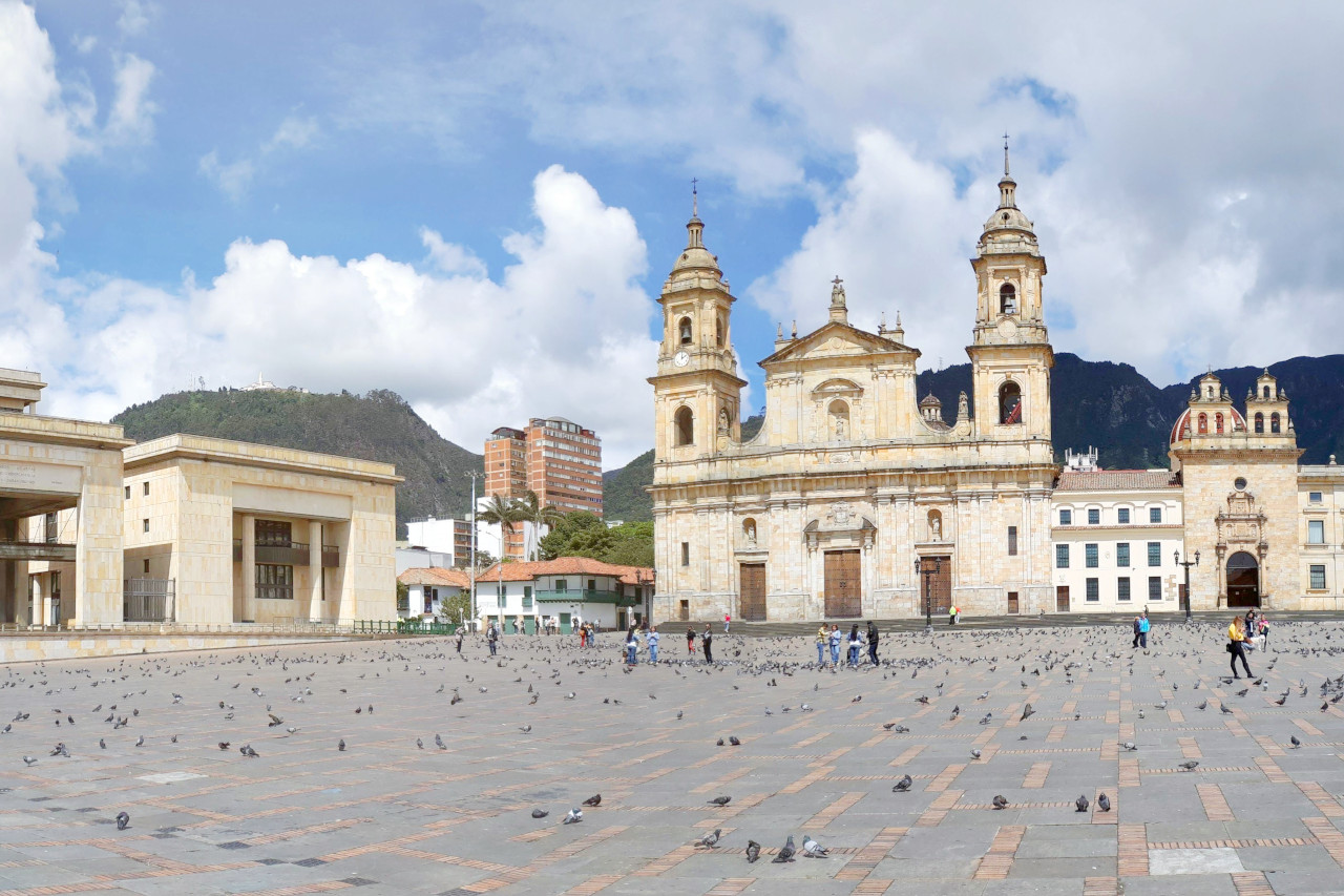 Plaza de Bolívar in Bogotá
Climate Map
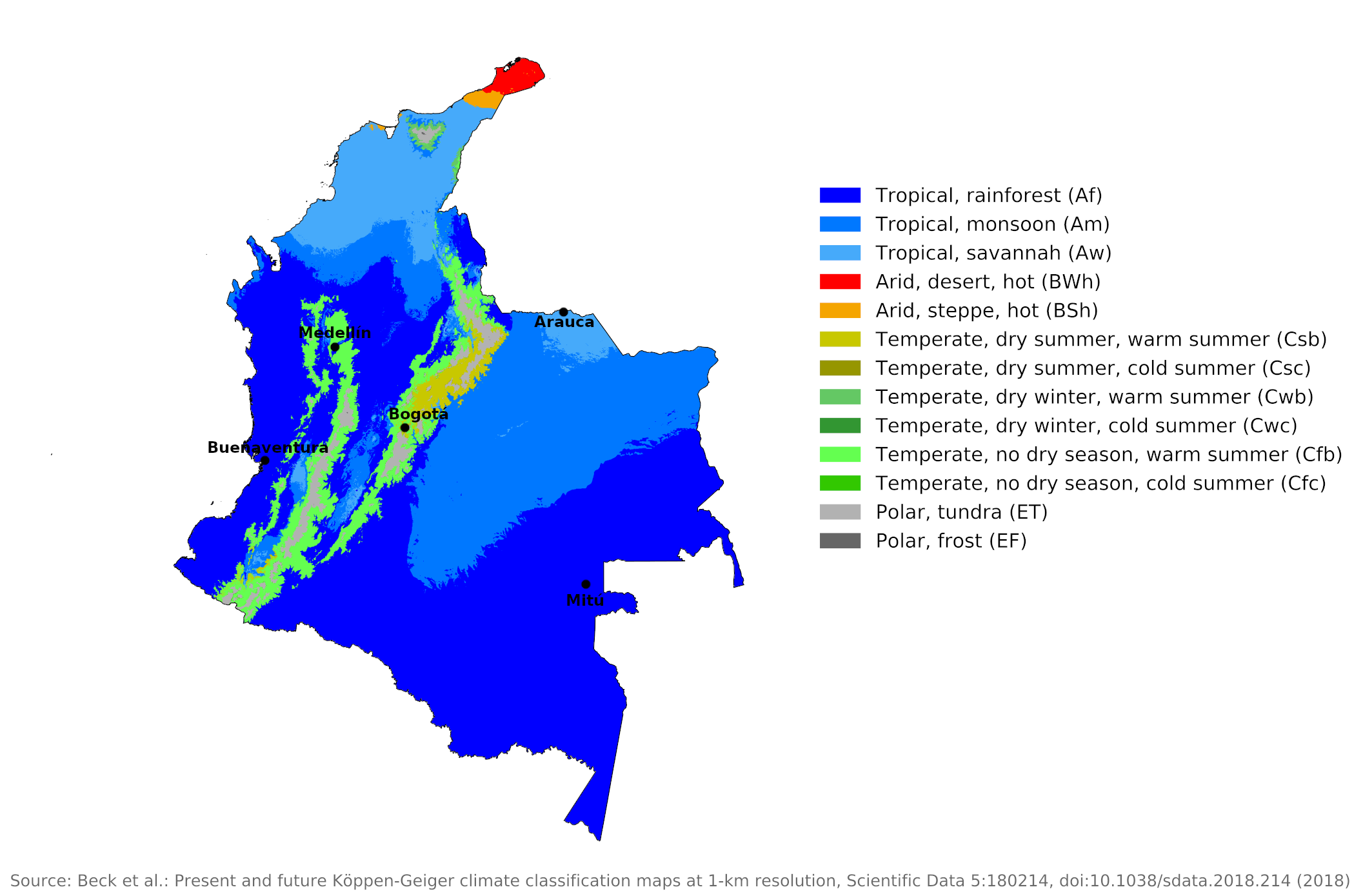 Climate map of the Colombia
What is the climate of Colombia like?
Colombia has a coastline on both the Pacific Ocean and the Caribbean Sea. It borders Panama on the northwest, Venezuela and Brazil on the east, and Peru and Ecuador on the south. It's about twice the size of France or the state of Texas.
Although situated on the equator, Colombia has a striking variety in temperatures, mainly as a result of differences in elevation. Colombia experiences a tropical climate, but in the higher parts of the country this is greatly altered by altitude. There are narrow plains along the coast, but inland the altitude rises sharply up to the high mountain ranges of the Andes. In the east of the country there are extensive lowlands in the forested Amazon basin. Temperatures range from very hot at sea level to relatively cold at higher elevations but vary little with the season. Breezes on the Caribbean coast, however, reduce both heat and precipitation.
The habitable areas of the country are divided into three climatic zones: hot (tierra caliente), below 1,000 meters (3,300 feet) in elevation and with temperatures usually between 24°C and 27°C (75°–81°F); temperate (tierra templada), 1,000 to 2,000 meters (3,300–6,500 feet), with an average temperature of 18°C (64°F); and cold (tierra fria), from 2,000 meters to about 3,500 meters (3,000–11,500 feet), with annual temperatures averaging 13°C (55°F). In the high, bleak, treeless mountain areas (usually referred to as the paramos) above 3,000 meters (10,000 feet), there are very cold temperatures, often between -17°C and -13°C (1°–9°F). Some of Colombia's mountains are perennially covered with snow and ice above 4,600 meters (15,000 feet).
Western lowlands
The hottest area, known as the 'tierra caliente', is a tropical zone that extends vertically from sea level to about 1,000 meters (3,300 feet). In this range, the temperature is usually between 24 and 27°C (75°F and 81°F), with a maximum near 38°C (100°F) and a minimum of 18°C (64°F). On the Pacific coast and the lower slopes of the western Andes, rainfall exceeds 2,500 millimeters (100 inches) almost everywhere, and exceeds 5,000 millimeters (200 inches) in many places. All months are wet. Temperatures and humidity remain high year round and the climate is generally muggy and oppressive. As a result, the coastal plain is covered with swamps and tangled forests.
An unusual feature of this area is the fact that the heaviest rainfall occurs at night, which is rare for equatorial regions, although thunderstorms are common in the afternoon. Buenaventura is typical of this area. The coastal areas of the Caribbean are not as wet, and there is a drier period from December to March. The area is also hot and humid. To the east of this coast, near the Venezuelan border, annual rainfall is low for a tropical coastal region.
| Climate data for Buenaventura | |||||||||||||
|---|---|---|---|---|---|---|---|---|---|---|---|---|---|
| Month | Jan | Feb | Mar | Apr | May | Jun | Jul | Aug | Sep | Oct | Nov | Dec | Year |
| Average high °C (°F) | 29.6 (85.3) | 30.6 (87.1) | 30.9 (87.6) | 31.1 (88.0) | 30.9 (87.6) | 30.4 (86.7) | 30.3 (86.5) | 30.4 (86.7) | 30.2 (86.4) | 30.0 (86.0) | 29.6 (85.3) | 29.6 (85.3) | 30.3 (86.5) |
| Daily mean °C (°F) | 25.8 (78.4) | 26.1 (79.0) | 26.4 (79.5) | 26.4 (79.5) | 26.3 (79.3) | 26.0 (78.8) | 25.9 (78.6) | 26.0 (78.8) | 25.9 (78.6) | 25.7 (78.3) | 25.6 (78.1) | 25.7 (78.3) | 26.0 (78.8) |
| Average low °C (°F) | 22.9 (73.2) | 23.1 (73.6) | 23.1 (73.6) | 23.1 (73.6) | 22.9 (73.2) | 22.7 (72.9) | 22.7 (72.9) | 22.7 (72.9) | 22.7 (72.9) | 22.6 (72.7) | 22.7 (72.9) | 22.7 (72.9) | 22.8 (73.1) |
| Average precipitation mm (inches) | 413.9 (16.30) | 290.9 (11.45) | 392.7 (15.46) | 530.2 (20.87) | 618.9 (24.37) | 533.3 (21.00) | 578.3 (22.77) | 666.2 (26.23) | 781.2 (30.76) | 807.3 (31.78) | 713.9 (28.11) | 571.4 (22.50) | 6,898.2 (271.6) |
| Source: Instituto de Hidrologia Meteorologia y Estudios Ambientales | |||||||||||||
Highlands
Most of central Colombia is mountainous; the higher Andean peaks rise to over 5,500 meters (18,000 feet). The Andes here consist of a series of mountain ranges between which the great rivers Magdelena and Cauca flow north in wide valleys. Depending on the altitude, there are significant temperature differences. A temperate zone or 'tierra templada' exists at elevations between 1,000 and 2,000 meters (3,300 and 6,500 ft) with an average temperature of 18°C (64°F). At altitudes between 2,000 and 3,500 meters (6,500 and 11,500 ft) one encounters the 'tierra fría', or cold land, which has average annual temperatures of 13°C (55°F). Chillier temperatures are encountered above 3,500 meters (11,500 feet), often between -17°C and 13°C (1°F and 55°F).
The temperate zone covers about 8 percent of the country. This zone includes the lower slopes of the Cordillera Oriental and the Cordillera Central and most of the intermontane valleys. The important city of Medellín at 1,500 meters (4,900 feet) is located in this zone, where rainfall is moderate, and the mean annual temperature varies between 19°C and 24°C, depending on the elevation. In the higher elevations of this zone, farmers benefit from two wet and two dry seasons each year; January through March and July through September are the dry seasons.
| Climate data for Medellín | |||||||||||||
|---|---|---|---|---|---|---|---|---|---|---|---|---|---|
| Month | Jan | Feb | Mar | Apr | May | Jun | Jul | Aug | Sep | Oct | Nov | Dec | Year |
| Average high °C (°F) | 27.8 (82.0) | 28.2 (82.8) | 28.1 (82.6) | 27.6 (81.7) | 27.8 (82.0) | 28.2 (82.8) | 28.4 (83.1) | 28.5 (83.3) | 28.0 (82.4) | 27.2 (81.0) | 27.1 (80.8) | 27.2 (81.0) | 27.8 (82.0) |
| Daily mean °C (°F) | 22.4 (72.3) | 22.7 (72.9) | 22.7 (72.9) | 22.4 (72.3) | 22.6 (72.7) | 22.9 (73.2) | 23.1 (73.6) | 23.1 (73.6) | 22.4 (72.3) | 21.8 (71.2) | 21.8 (71.2) | 21.9 (71.4) | 22.5 (72.5) |
| Average low °C (°F) | 17.2 (63.0) | 17.5 (63.5) | 17.7 (63.9) | 17.8 (64.0) | 17.8 (64.0) | 17.4 (63.3) | 17.1 (62.8) | 17.2 (63.0) | 17.0 (62.6) | 17.0 (62.6) | 17.3 (63.1) | 17.2 (63.0) | 17.4 (63.3) |
| Average precipitation mm (inches) | 63.2 (2.49) | 81.4 (3.20) | 129.1 (5.08) | 170.7 (6.72) | 213.5 (8.41) | 149.4 (5.88) | 133.1 (5.24) | 139.7 (5.50) | 181.8 (7.16) | 226.7 (8.93) | 158.9 (6.26) | 104.8 (4.13) | 1,752.3 (68.99) |
| Source: Instituto de Hidrologia, Meteorologia y Estudios Ambientales | |||||||||||||
Mountains over 4,500 meters (15,000 feet) receive most of their precipitation as snow. The entire region receives copious rainfall of between 1,000 and 2,500 millimeters (40 to 100 inches) per year, and this is well distributed throughout the year with no real dry season. The western areas are wetter than those in the east.
The cold or cool zone constitutes about 6 percent of the country, including some of the most densely populated plateaus and terraces of the Colombian Andes. The mean temperature ranges between 10°C and 19°C, and the wet seasons occur in April and May and from September to December, as in the high elevations of the temperate zone. Bogotá is typical of the conditions in the higher 'tierra fria' zone. Here the weather and climate really are those of "eternal spring", as it is understood in temperate latitudes.
Nights are cool but never really cold, and frost is unknown at this altitude. Days feel warm in the sun but are never really hot. Rain and afternoon clouds are common. The sun shines three to five hours a day all year round. At lower levels and in the drier valleys, the sun is more likely to be six to seven hours a day. Wet and dry seasons, or "winter" and "summer," generally alternate in three-month cycles, as in Bogotá, where rainfall is heaviest and most consistent during the April-June and October-December periods.
| Climate data for Bogotá | |||||||||||||
|---|---|---|---|---|---|---|---|---|---|---|---|---|---|
| Month | Jan | Feb | Mar | Apr | May | Jun | Jul | Aug | Sep | Oct | Nov | Dec | Year |
| Average high °C (°F) | 20.2 (68.4) | 20.3 (68.5) | 19.4 (66.9) | 20.1 (68.2) | 19.0 (66.2) | 19.2 (66.6) | 18.6 (65.5) | 18.8 (65.8) | 19.2 (66.6) | 19.5 (67.1) | 19.6 (67.3) | 19.9 (67.8) | 19.6 (67.3) |
| Daily mean °C (°F) | 14.3 (57.7) | 14.5 (58.1) | 14.9 (58.8) | 14.9 (58.8) | 15.0 (59.0) | 14.5 (58.1) | 14.6 (58.3) | 14.1 (57.4) | 14.3 (57.7) | 14.3 (57.7) | 14.4 (57.9) | 14.6 (58.3) | 14.4 (57.9) |
| Average low °C (°F) | 7.6 (45.7) | 8.4 (47.1) | 9.5 (49.1) | 9.7 (49.5) | 9.7 (49.5) | 9.5 (49.1) | 9.2 (48.6) | 8.9 (48.0) | 8.7 (47.7) | 9.0 (48.2) | 9.2 (48.6) | 8.0 (46.4) | 9.0 (48.2) |
| Average precipitation mm (inches) | 50 (2.0) | 68 (2.7) | 91 (3.6) | 135 (5.3) | 120 (4.7) | 54 (2.1) | 35 (1.4) | 45 (1.8) | 70 (2.8) | 137 (5.4) | 127 (5.0) | 81 (3.2) | 1,012 (39.8) |
| Source: Instituto de Hidrología, Meteorología y Estudios Ambientales | |||||||||||||
Eastern lowlands
The great Andean barrier that crosses the republic from south to north acts as a condenser for the prevailing easterly winds from the Atlantic, causing very heavy rainfall on its eastern slopes and over the forested Amazonian plain. In this region there are high temperatures and high humidity. The lowlands in the east of the country are therefore sparsely populated.
The climate here is hot year-round and wet weather is common, with annual rainfall of 2,000 to 2,500 millimeters (80 to 100 inches) or more. As in other parts of the northern Amazon basin, there are two relatively wetter periods: December through January and April through July. Mitú in the department of Vaupés is representative of this humid equatorial lowland.
| Climate data for Mitú | |||||||||||||
|---|---|---|---|---|---|---|---|---|---|---|---|---|---|
| Month | Jan | Feb | Mar | Apr | May | Jun | Jul | Aug | Sep | Oct | Nov | Dec | Year |
| Average high °C (°F) | 31.3 (88.3) | 31.5 (88.7) | 32.0 (89.6) | 31.2 (88.2) | 29.2 (84.6) | 29.5 (85.1) | 29.2 (84.6) | 30.1 (86.2) | 30.8 (87.4) | 30.6 (87.1) | 31.0 (87.8) | 30.9 (87.6) | 30.6 (87.1) |
| Daily mean °C (°F) | 26.4 (79.5) | 26.3 (79.3) | 26.5 (79.7) | 26.4 (79.5) | 25.6 (78.1) | 25.2 (77.4) | 25.1 (77.2) | 25.7 (78.3) | 25.9 (78.6) | 26.3 (79.3) | 25.9 (78.6) | 26.3 (79.3) | 26.0 (78.7) |
| Average low °C (°F) | 20.1 (68.2) | 20.2 (68.4) | 21.3 (70.3) | 21.1 (70.0) | 21.3 (70.3) | 21.5 (70.7) | 19.9 (67.8) | 20.5 (68.9) | 20.8 (69.4) | 21.0 (69.8) | 21.1 (70.0) | 19.9 (67.8) | 20.7 (69.3) |
| Average precipitation mm (inches) | 257.1 (10.12) | 209.5 (8.25) | 228.8 (9.01) | 331.2 (13.04) | 381.5 (15.02) | 373.6 (14.71) | 385.4 (15.17) | 301.2 (11.86) | 241.0 (9.49) | 234.0 (9.21) | 219.0 (8.62) | 193.3 (7.61) | 3,355.6 (132.11) |
| Source: Instituto de Hidrologia Meteorologia y Estudios Ambientales | |||||||||||||
In the open llanos of the tributaries of the Orinoco, the year is divided equally, an alternating wet and dry season, sunny temperatures are high followed by cool nights, and wet season temperatures are even higher. Rainfall is heavy in the rainy season, causing many of the rivers to spread over large areas, but in the dry season the flooded plains dry up, the great rivers fed by the snow and rain of the Andes are confined to their banks, the shallow lagoons and small streams dry up, the vegetation disappears and the flat plain becomes desert. Check out the climate of Arauca in northeastern Colombia.
| Climate data for Arauca | |||||||||||||
|---|---|---|---|---|---|---|---|---|---|---|---|---|---|
| Month | Jan | Feb | Mar | Apr | May | Jun | Jul | Aug | Sep | Oct | Nov | Dec | Year |
| Average high °C (°F) | 32.7 (90.9) | 34.2 (93.6) | 34.4 (93.9) | 33.3 (91.9) | 30.5 (86.9) | 29.9 (85.8) | 29.4 (84.9) | 30.3 (86.5) | 31.2 (88.2) | 31.6 (88.9) | 31.4 (88.5) | 31.4 (88.5) | 31.7 (89.0) |
| Daily mean °C (°F) | 27.2 (81.0) | 28.3 (82.9) | 28.6 (83.5) | 27.6 (81.7) | 26.4 (79.5) | 25.8 (78.4) | 25.5 (77.9) | 25.9 (78.6) | 26.3 (79.3) | 26.6 (79.9) | 26.8 (80.2) | 26.7 (80.1) | 26.8 (80.3) |
| Average low °C (°F) | 20.1 (68.2) | 20.5 (68.9) | 21.4 (70.5) | 22.3 (72.1) | 22.3 (72.1) | 22.1 (71.8) | 22.1 (71.8) | 22.1 (71.8) | 22.2 (72.0) | 22.2 (72.0) | 22.2 (72.0) | 21.3 (70.3) | 21.7 (71.1) |
| Average precipitation mm (inches) | 13.0 (0.51) | 12.0 (0.47) | 39.7 (1.56) | 130.9 (5.15) | 224.1 (8.82) | 313.7 (12.35) | 304.7 (12.00) | 234.2 (9.22) | 204.3 (8.04) | 186.7 (7.35) | 110.1 (4.33) | 24.6 (0.97) | 1,798 (70.77) |
| Source: Instituto de Hidrologia Meteorologia y Estudios Ambientales | |||||||||||||
Rainfall
Rainfall is moderate to heavy in most parts of the country; The average annual precipitation totals 3,000 millimeters (120 inches). The heavier rainfall occurs in the Pacific lowlands and parts of eastern Colombia, where it rains almost every day and rainforests predominate. Rainfall exceeds 7,500 millimeters (300 inches) per year in most of the Pacific lowlands, making this region one of the wettest regions in the world, particularly in the Choco Department, which receives an average annual rainfall of almost 10,000 millimeters (400 inches).
Much of the Caribbean interior is permanently flooded, more from poor drainage than moderate rainfall during the rainy season from May to October. In eastern Colombia, precipitation decreases from 6,400 millimeters (250 inches) in parts of Andean Piedmont to 2,500 millimeters (100 inches) in an easterly direction. In contrast, the department of La Guajira on the Caribbean coast is the driest place in Colombia, with an average annual rainfall of just 250 millimeters (10 inches).
References
- E. A. Pearce, Charles Gordon Smith, (1990) The Hutchinson World Weather Guide, John Murray Press. ISBN 1859863426
- Timothy L. Gall, (ed.), (2003), Worldmark Encyclopedia of the Nations, Eleventh Edition, Thomson Gale
- Federal Research Division, Library of Congress, (2010), Colombia: a country study. Claitor's Pub. Division. ISBN 9780844495026
- Hugh Chisholm, (ed.), (1911), Encyclopædia Britannica, Eleventh edition, Cambridge University Press
The Climate of
Colombia
In summary:
Colombia’s climate is determined by altitude. The hot country, or tierra caliente, is the tropical zone, reaching from sea level to roughly 1,100 m (3,500 ft). Between 1,100 m (3,500 ft) and 2,000 m (6,500 ft) is the temperate zone, or tierra templada, where the average year-round temperature is about 18°C (64°F). Between 2,000 m (6,500 ft) and 3,000 m (10,000 ft) is the cold country, or tierra fría, with temperatures averaging a little over 13°C (55°F). Above the 3,000-m (10,000-ft) level the temperature varies from 13°C to –17°C (55° F to 1°F), according to altitude.
Rainfall is heaviest on the west coast and in the Andean area. Rainy and dry seasons, or "winter" and "summer," generally alternate in three-month cycles, as in Bogotá. Northern areas have only one long rainy season, from May through October.