The Climate of
Belize
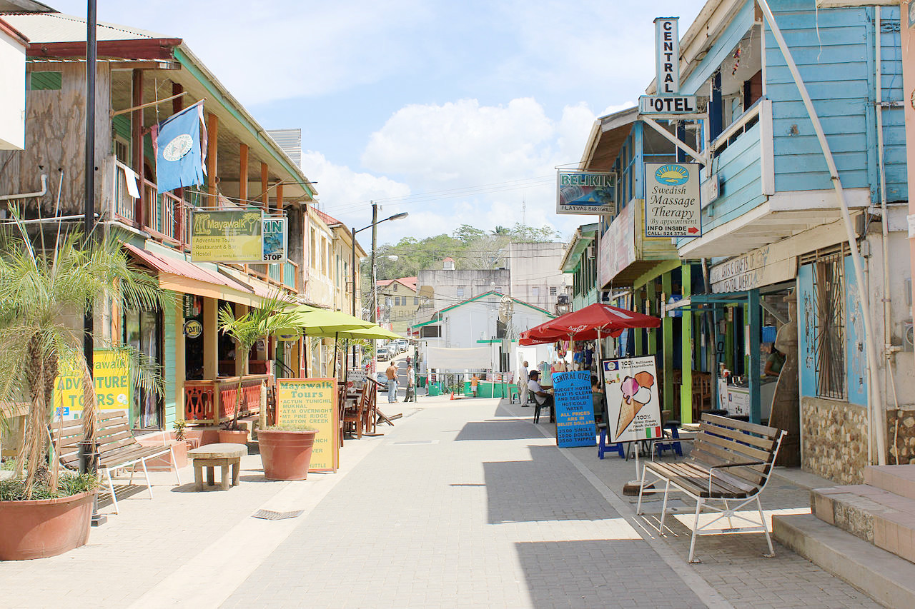 Burns Avenue in San Ignacio
Climate Map
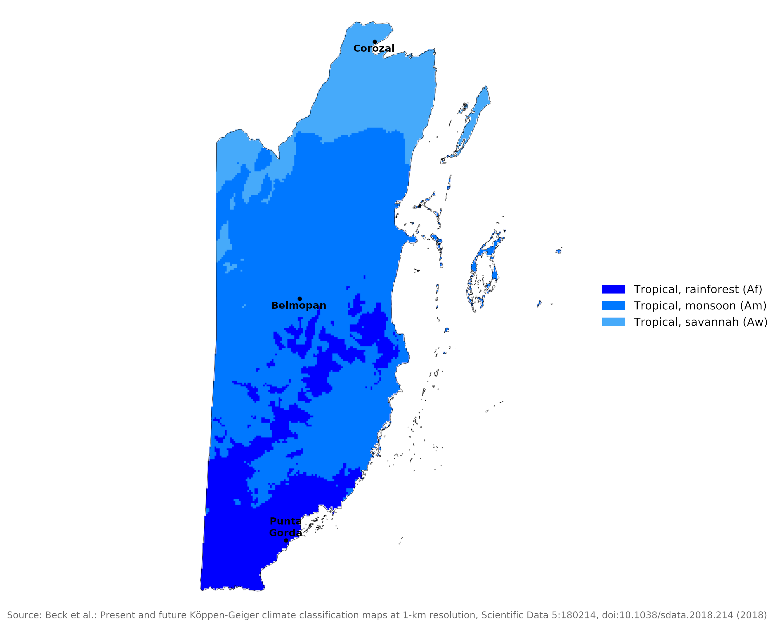 Climate map of Belize
What is the climate of Belize like?
Belize is one of the smaller countries in Central America. It lies between 16° and 18° N and borders Guatemala to the south and west and Mexico to the north . It has a long coastline on the Caribbean Sea. Much of the country is low-lying, so the weather and climate are typical of the tierra caliente, except in the southwest where the Maya Mountains rise to over 1,100 meters (3,600 feet).
Belize's climate is tropical and humid, but modified by the northeast trade winds that constantly blow toward the equator. Temperatures range between 16°C and 32°C (61°F and 90°F) along the coast and are slightly higher inland. Overall, the seasons are marked more by differences in humidity and rainfall than in temperature. The average annual humidity is 83 percent, but on many days the humidity is masked by cooling sea breezes. November to January are traditionally the coolest months, and February to May has a dry season. Some days and nights in the mountains can be very cold, but the average annual temperature there is a comfortable 22°C (72°F).
Easterly sea winds prevail for most of the year. The dry season lasts from mid-February to mid-May. Seasonal differences in rainfall are greatest in the northern and central regions of the country where, between January and April or May, fewer than 100 millimeters of rain fall per month. The dry season is shorter in the south, normally only lasting from February to April. A shorter, less rainy period, known locally as the "little dry," usually occurs in late July or August, after the initial onset of the rainy season.
It rains fairly heavily on the coast and although there is a wetter season between May and November, some rain does fall throughout the year. In many places, the rainy season is divided into two separate periods: a short period in May or June with heavy showers, and a longer season beginning in September and October and lasting through January, in which there are a few days without rain showers, with variations of severe thunderstorms. During the rainy season there are sometimes brief lulls, during which the temperature does not rise much, but the feeling of heat is great; but fortunately these quiet periods are rare and short-lived. Annual rainfall averages between 1,250 millimeters (50 inches) in the north of the country and more than 3,800 millimeters (150 inches) in the south. The number of rainy days varies greatly from place to place.
The country is occasionally hit by very heavy rains caused by tropical storms or hurricanes, which can damage homes and crops, but severe hurricanes are few and far between. The hurricane season lasts from July through October, which is the peak rainfall season. Belize City, once the capital, has often been damaged by hurricanes. In 1931 a hurricane destroyed over two-thirds of the buildings in Belize City and killed more than 1,000 people. In 1961 Hurricane Hattie struck the central coastal area of the country, with winds in excess of 300 kilometers per hour (185 miles per hour) and four-meter storm tides. The devastation of Belize City for the second time in thirty years prompted the relocation of the capital some eighty kilometers inland to the planned city of Belmopan.
The climate for Corozal shows the relatively "dry" conditions in the far north; the climate for Punta Gorda reflects the much wetter conditions in the extreme south of the country:
| Climate data for Corozal (1981–2010) | |||||||||||||
|---|---|---|---|---|---|---|---|---|---|---|---|---|---|
| Month | Jan | Feb | Mar | Apr | May | Jun | Jul | Aug | Sep | Oct | Nov | Dec | Year |
| Average high °C (°F) | 28.3 (82.9) | 30.3 (86.5) | 31.6 (88.9) | 32.8 (91.0) | 33.1 (91.6) | 32.8 (91.0) | 32.6 (90.7) | 32.7 (90.9) | 33.0 (91.4) | 31.7 (89.1) | 29.9 (85.8) | 28.7 (83.7) | 31.5 (88.7) |
| Daily mean °C (°F) | 22.8 (73.0) | 24.5 (76.1) | 25.4 (77.7) | 26.7 (80.1) | 28.1 (82.6) | 28.3 (82.9) | 28.0 (82.4) | 27.9 (82.2) | 27.8 (82.0) | 26.6 (79.9) | 24.7 (76.5) | 23.5 (74.3) | 26.2 (79.2) |
| Average low °C (°F) | 17.3 (63.1) | 18.7 (65.7) | 19.1 (66.4) | 20.7 (69.3) | 23.0 (73.4) | 23.8 (74.8) | 23.4 (74.1) | 23.2 (73.8) | 22.7 (72.9) | 21.6 (70.9) | 19.5 (67.1) | 18.2 (64.8) | 20.9 (69.6) |
| Average precipitation mm (inches) | 58.5 (2.30) | 31.9 (1.26) | 32.1 (1.26) | 45.7 (1.80) | 107.5 (4.23) | 216.8 (8.54) | 140.4 (5.53) | 172.6 (6.80) | 195.7 (7.70) | 193.7 (7.63) | 95.5 (3.76) | 64.8 (2.55) | 1,355.2 (53.36) |
| Source: National Meteorological Service of Belize | |||||||||||||
| Climate data for Belmopan (1991–2020) | |||||||||||||
|---|---|---|---|---|---|---|---|---|---|---|---|---|---|
| Month | Jan | Feb | Mar | Apr | May | Jun | Jul | Aug | Sep | Oct | Nov | Dec | Year |
| Average high °C (°F) | 28.2 (82.8) | 29.7 (85.5) | 31.2 (88.2) | 33.5 (92.3) | 34.1 (93.4) | 32.7 (90.9) | 32.2 (90.0) | 32.6 (90.7) | 32.5 (90.5) | 31.2 (88.2) | 29.4 (84.9) | 28.6 (83.5) | 31.3 (88.3) |
| Daily mean °C (°F) | 23.7 (74.7) | 24.4 (75.9) | 25.5 (77.9) | 27.6 (81.7) | 28.6 (83.5) | 28.3 (82.9) | 27.7 (81.9) | 27.9 (82.2) | 27.9 (82.2) | 26.8 (80.2) | 25.1 (77.2) | 24.2 (75.6) | 26.5 (79.7) |
| Average low °C (°F) | 19.1 (66.4) | 19.2 (66.6) | 19.8 (67.6) | 21.7 (71.1) | 23.1 (73.6) | 23.8 (74.8) | 23.3 (73.9) | 23.2 (73.8) | 23.2 (73.8) | 22.5 (72.5) | 20.7 (69.3) | 19.8 (67.6) | 21.6 (70.9) |
| Average precipitation mm (inches) | 135.2 (5.32) | 51.3 (2.02) | 48.5 (1.91) | 41.4 (1.63) | 119.3 (4.70) | 259.9 (10.23) | 245.3 (9.66) | 226.1 (8.90) | 221.8 (8.73) | 244.2 (9.61) | 201.9 (7.95) | 134.9 (5.31) | 1,929.8 (75.97) |
| Source: National Meteorological Service of Belize | |||||||||||||
| Climate data for Punta Gorda (1991–2020) | |||||||||||||
|---|---|---|---|---|---|---|---|---|---|---|---|---|---|
| Month | Jan | Feb | Mar | Apr | May | Jun | Jul | Aug | Sep | Oct | Nov | Dec | Year |
| Average high °C (°F) | 28.2 (82.8) | 29.5 (85.1) | 30.6 (87.1) | 32.0 (89.6) | 32.2 (90.0) | 31.9 (89.4) | 31.3 (88.3) | 32.0 (89.6) | 32.3 (90.1) | 31.4 (88.5) | 29.9 (85.8) | 29.1 (84.4) | 30.9 (87.6) |
| Daily mean °C (°F) | 23.4 (74.1) | 24.7 (76.5) | 25.3 (77.5) | 26.9 (80.4) | 27.5 (81.5) | 27.5 (81.5) | 27.1 (80.8) | 27.3 (81.1) | 27.4 (81.3) | 26.7 (80.1) | 25.1 (77.2) | 23.8 (74.8) | 26.1 (79.0) |
| Average low °C (°F) | 18.6 (65.5) | 19.8 (67.6) | 20.1 (68.2) | 21.9 (71.4) | 22.8 (73.0) | 23.1 (73.6) | 22.9 (73.2) | 22.5 (72.5) | 22.6 (72.7) | 22.1 (71.8) | 20.3 (68.5) | 18.6 (65.5) | 21.3 (70.3) |
| Average precipitation mm (inches) | 170.6 (6.72) | 94.7 (3.73) | 73.4 (2.89) | 82.0 (3.23) | 205.1 (8.07) | 447.0 (17.60) | 709.8 (27.94) | 629.7 (24.79) | 528.8 (20.82) | 361.4 (14.23) | 264.8 (10.43) | 178.5 (7.03) | 3,745.8 (147.48) |
| Source: National Meteorological Service of Belize | |||||||||||||
Rainfall Map
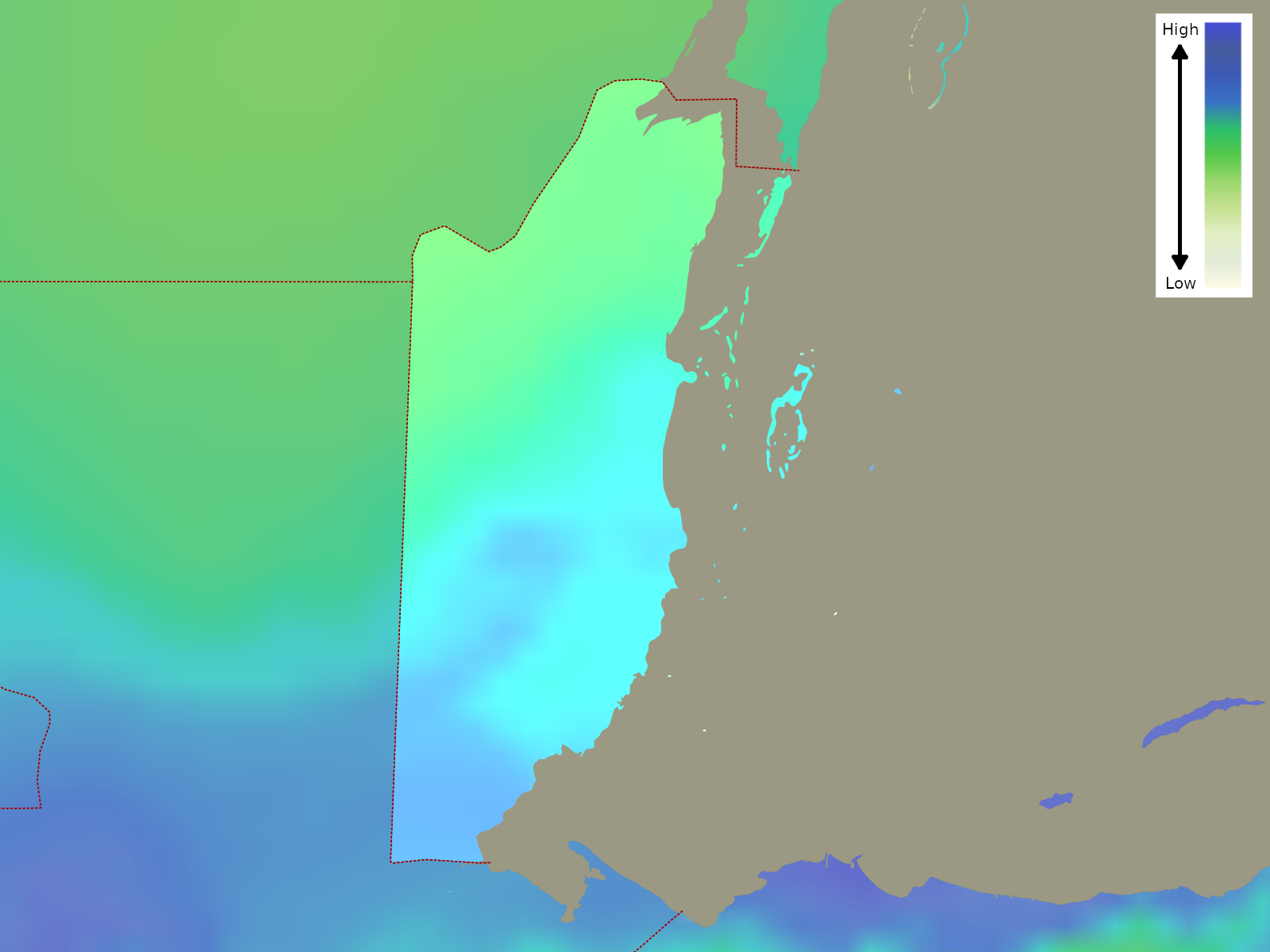 Rainfall distribution across Belize
References
- E. A. Pearce, Charles Gordon Smith, (1990) The Hutchinson World Weather Guide, John Murray Press. ISBN 1859863426
- Timothy L. Gall, (ed.), (2003), Worldmark Encyclopedia of the Nations, Eleventh Edition, Thomson Gale
- Federal Research Division, Library of Congress, (1993), Guyana and Belize: country studies. Claitor's Pub. Division. ISBN 084440778X
- Hugh Chisholm, (ed.), (1911), Encyclopædia Britannica, Eleventh edition, Cambridge University Press
The Climate of
Belize
In summary:
The climate of Belize is subtropical and humid, tempered by predominant northeast trade winds that keep temperatures between 16° and 32°C (61–90°F) in the coastal region; inland temperatures are slightly higher. The seasons are marked more by differences of humidity than of temperature.
Annual rainfall averages vary from 1270 mm (50 in) in the north to more than 3800 mm (150 in) in the south. There is a dry season from February to May. Hurricanes occur from July to October.