The Climate of
Mexico
 Streets of Mazatlán, Sinaloa
Climate Map
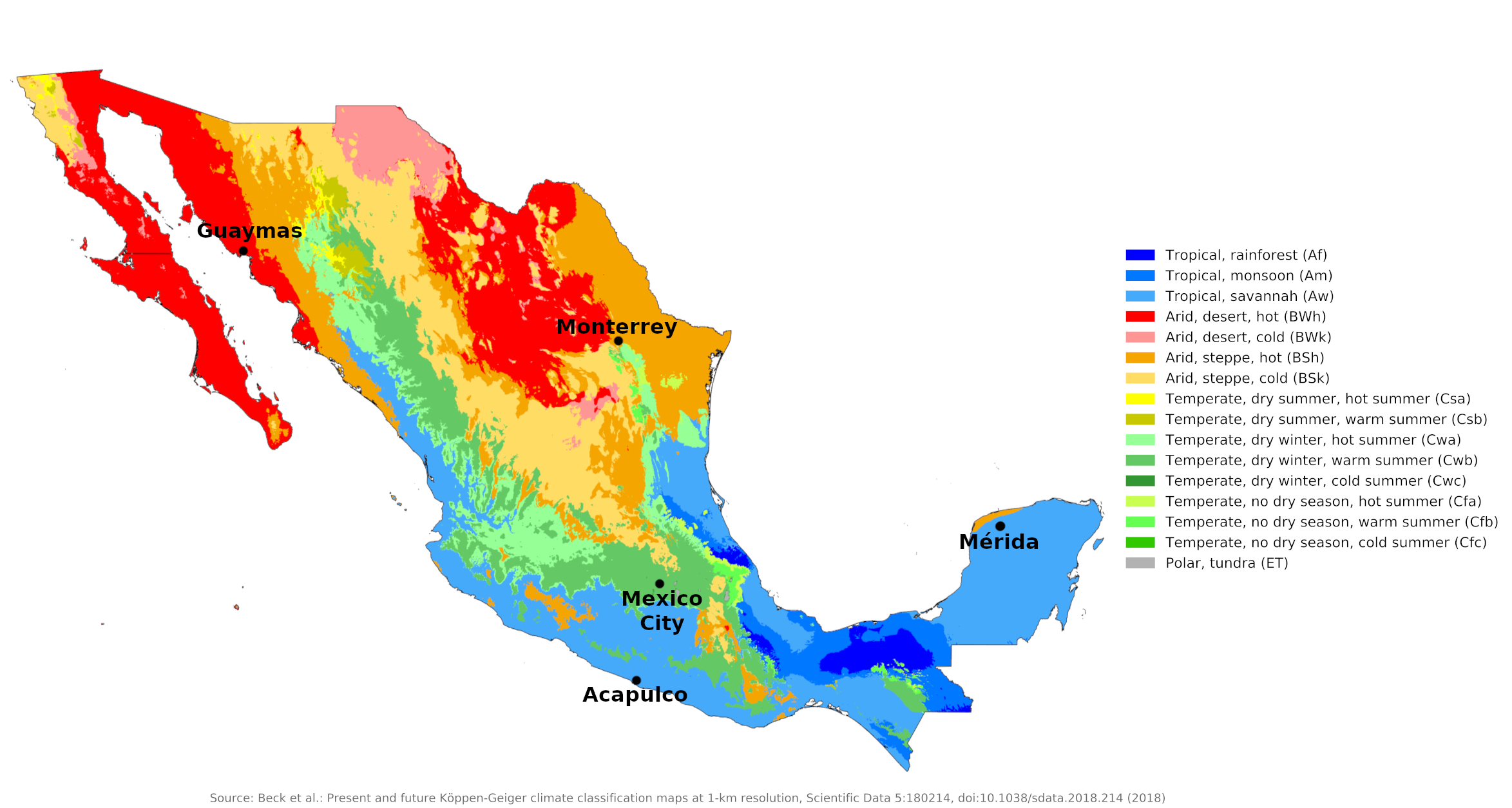 Climate map of Mexico
What is the climate of Mexico like?
Mexico, the largest country in Central America, borders the United States to the north and Guatemala and Belize to the south. About three times the size of Texas, Mexico is roughly wedge-shaped, being widest in the north and tapering to the narrow Isthmus of Tehuantepec in the south. It lies between 14° and 32°N, the northern half of the country lies outside the tropics. Almost two-thirds of the country consists of plateaux and high mountains with a warm-temperate climate; other parts have a tropical climate with a temperature reduced by altitude.
There are three major climatic influences that help determine the character of the climate in different parts of Mexico. The cold California current flowing south on the Pacific coast has the effect of lowering temperatures and reducing rainfall on the west coast to the tip of the Baja California peninsula. This and the influence of the North Pacific anticyclone help make much of the desert or semi-desert of northwestern Mexico. This is a continuation of the United States Dry Zone in Southern California, New Mexico and Arizona.
The warm waters of the Caribbean Sea and the influence of constant northeast trade winds make the eastern coastal region a typical tropical coast with a pronounced single summer rainy season. The weather and climate of this region, especially south of Tampico, has a lot in common with the Caribbean islands.
An important influence is the presence of the large continental landmass of North America to the north. This area gets very cold in winter—especially when cold air pours down from the Canadian Arctic—and very warm in summer. The northern part of Mexico shares these extreme temperature conditions. In winter, cold waves on the East Coast as far as Tampico or Veracruz can bring near freezing conditions for a few days. Snow has fallen as far as Tampico, which is in the tropics. The west coast is protected from such cold waves by the mountains and plateaux of central Mexico.
As in other mountainous South and Central American countries, climate zones are described by altitude using Spanish terms: tierra caliente, the area below about 600 meters (2,000 feet); tierra templada, the land between 600 and 1,800 meters (2,000 to 6,000 feet); and tierra fria, the mountains and plateaux above this plain. A fairly narrow strip of coastline on the Pacific coast falls into the tierra caliente category, but there is a more extensive area on the Caribbean coast, including the entire Yucatan Peninsula. Most of Mexico falls within tierra templada and tierra fria. This classification hardly takes precipitation into account and is mainly based on temperature. In most Tierra Fria, winter nighttime frosts are common and snow can occur anywhere, but only above 3,000–3,600 meters (10,000–12,000 feet).
The rainy season across the country is the high sun season from May to October. The rest of the year is not entirely rain-free, but the amount and frequency of rain in the winter season is low. The wettest part of the country is the lowlands on the Caribbean coast; The north coast of the Yucatan Peninsula is relatively much drier than the east coast or inland. Annual rainfall here ranges from 1,000 to 1,500 millimeters (40 to 60 inches), but some locations in northern Yucatan reach less than 500 millimeters (20 inches). The Pacific and Gulf of California coasts, north of the Tropic of Cancer, receive less than 250 millimeters (10 inches) of rain per year, but this increases to between 1,000 and 1,500 millimeters (40 to 60 inches) southward. Rainfall is heaviest where the coast is situated behind high mountains. On the plateau, where part of the winter precipitation can fall as snow, annual precipitation tends to be lower than on the coast. Much of the plateau is protected from maritime influences by the high mountains of the eastern and western Sierra Madre, so there is less rainfall. Annual rates of 500 millimeters (20 inches) or less in the extreme north to 875 millimeters (35 inches) in the middle and south are typical of the central highland region.
Most parts of Mexico enjoy sunny weather for much of the year. The cloudiest regions are the wetter parts of the east coast and the northern part of the Pacific coast, where low clouds and fog form over the cold ocean currents. The drier regions of the interior and much of the tierra templada get plenty of sunshine: seven or eight hours a day in the drier months, to five or six in the wetter season.
The North
Arid or semiarid conditions are encountered in the Baja Peninsula, the northwestern state of Sonora, the northern plateau ("altiplano"), and significant portions of the southern altiplano. Rainfall in these regions averages between 200 and 600 millimeters (8–24 inches) per year. Low-lying areas are particularly hot during the summer, although they generally have lower yearly temperature averages (from 20°C to 25°C or 68–77°F) because of more moderate conditions during the winter. A small coastal area of the far northwest around Tijuana has a Mediterranean climate with considerable coastal fog and a rainy season that occurs in winter.
Guaymas is representative of the drier northwest of the country. Monterrey, in the northeast is at the upper limit of Tierra Caliente.
| Climate data for Guaymas, Sonora (1951–1980) | |||||||||||||
|---|---|---|---|---|---|---|---|---|---|---|---|---|---|
| Month | Jan | Feb | Mar | Apr | May | Jun | Jul | Aug | Sep | Oct | Nov | Dec | Year |
| Average high °C (°F) | 23.9 (75.0) | 24.6 (76.3) | 26.1 (79.0) | 28.5 (83.3) | 31.9 (89.4) | 34.2 (93.6) | 35.5 (95.9) | 35.4 (95.7) | 35.3 (95.5) | 32.5 (90.5) | 27.7 (81.9) | 24.0 (75.2) | 30.0 (86.0) |
| Daily mean °C (°F) | 18.5 (65.3) | 19.3 (66.7) | 20.9 (69.6) | 23.4 (74.1) | 26.3 (79.3) | 29.5 (85.1) | 31.2 (88.2) | 31.2 (88.2) | 30.9 (87.6) | 27.8 (82.0) | 22.5 (72.5) | 19.2 (66.6) | 25.1 (77.2) |
| Average low °C (°F) | 13.7 (56.7) | 14.3 (57.7) | 15.6 (60.1) | 18.0 (64.4) | 20.9 (69.6) | 24.9 (76.8) | 27.6 (81.7) | 27.3 (81.1) | 27.0 (80.6) | 23.2 (73.8) | 17.9 (64.2) | 14.4 (57.9) | 20.4 (68.7) |
| Average precipitation mm (inches) | 15.2 (0.60) | 6.3 (0.25) | 2.9 (0.11) | 0.8 (0.03) | 1.9 (0.07) | 0.7 (0.03) | 46.1 (1.81) | 69.7 (2.74) | 35.0 (1.38) | 14.6 (0.57) | 10.3 (0.41) | 14.7 (0.58) | 218.2 (8.59) |
| Source: Colegio de Postgraduados | |||||||||||||
| Climate data for Monterrey (1951–2010) | |||||||||||||
|---|---|---|---|---|---|---|---|---|---|---|---|---|---|
| Month | Jan | Feb | Mar | Apr | May | Jun | Jul | Aug | Sep | Oct | Nov | Dec | Year |
| Average high °C (°F) | 20.7 (69.3) | 23.2 (73.8) | 26.9 (80.4) | 30.0 (86.0) | 32.2 (90.0) | 33.8 (92.8) | 34.8 (94.6) | 34.5 (94.1) | 31.5 (88.7) | 27.6 (81.7) | 24.1 (75.4) | 21.2 (70.2) | 28.4 (83.1) |
| Daily mean °C (°F) | 14.4 (57.9) | 16.6 (61.9) | 20.0 (68.0) | 23.4 (74.1) | 26.2 (79.2) | 27.9 (82.2) | 28.6 (83.5) | 28.5 (83.3) | 26.2 (79.2) | 22.4 (72.3) | 18.4 (65.1) | 15.1 (59.2) | 22.3 (72.1) |
| Average low °C (°F) | 8.2 (46.8) | 10.0 (50.0) | 13.2 (55.8) | 16.7 (62.1) | 20.2 (68.4) | 22.0 (71.6) | 22.3 (72.1) | 22.5 (72.5) | 20.9 (69.6) | 17.2 (63.0) | 12.7 (54.9) | 9.1 (48.4) | 16.3 (61.3) |
| Average precipitation mm (inches) | 16.6 (0.65) | 16.5 (0.65) | 19.9 (0.78) | 29.7 (1.17) | 52.3 (2.06) | 68.4 (2.69) | 43.0 (1.69) | 81.6 (3.21) | 150.6 (5.93) | 75.1 (2.96) | 23.0 (0.91) | 14.1 (0.56) | 590.8 (23.26) |
| Source: Servicio Meteorologico Nacional | |||||||||||||
The Center
This region includes most of the major populated areas of the southern altiplano, including Mexico City. Towns and cities at altitude have relatively constant, pleasant temperatures throughout the year. Between 1,000 and 2,000 meters (3,300–6,600 feet), one encounters yearly average temperatures between 16°C and 20°C (61–68°F). At altitudes well-above 2,000 meters (6,600 feet), temperatures can drop to an average yearly range between 8°C and 12°C (46–54°F).
Mexico City is typical of Tierra Fria. At 2,240 meters (7,350 feet), Mexico City has a yearly median temperature of 18°C (64°F) with pleasant summers and mild winters. Average daily highs and lows for May, the warmest month, are 27°C and 13°C (80 and 56°F), and average daily highs and lows for January, the coldest month, are 21°C and 8°C (71 and 46°F).
Average rainfall totals in this region are between 600 and 1,000 millimeters (24–40 inches) in most of the year. There are very distince wet and dry seasons. Mexico City receives an average of only 6 millimeters (0.2 inches) of rain during December but more than 180 millimeters (7 inches) in July.
At Mexico City's altitude and higher, it may take visitors a few days to acclimatize to the lower atmospheric pressure, as sudden exertion can cause breathlessness. On the higher parts of the plateau, the sun can sometimes feel very strong during the day and the rapid drop in temperature at night can make it very chilly.
| Climate data for Mexico City (1981–2010) | |||||||||||||
|---|---|---|---|---|---|---|---|---|---|---|---|---|---|
| Month | Jan | Feb | Mar | Apr | May | Jun | Jul | Aug | Sep | Oct | Nov | Dec | Year |
| Average high °C (°F) | 21.8 (71.2) | 23.5 (74.3) | 25.7 (78.3) | 26.9 (80.4) | 26.8 (80.2) | 25.4 (77.7) | 24.1 (75.4) | 24.1 (75.4) | 23.4 (74.1) | 23.1 (73.6) | 22.7 (72.9) | 21.9 (71.4) | 24.1 (75.4) |
| Daily mean °C (°F) | 14.8 (58.6) | 16.2 (61.2) | 18.2 (64.8) | 19.7 (67.5) | 20.1 (68.2) | 19.5 (67.1) | 18.4 (65.1) | 18.5 (65.3) | 18.1 (64.6) | 17.2 (63.0) | 16.1 (61.0) | 14.9 (58.8) | 17.6 (63.7) |
| Average low °C (°F) | 7.8 (46.0) | 8.9 (48.0) | 10.6 (51.1) | 12.5 (54.5) | 13.3 (55.9) | 13.5 (56.3) | 12.7 (54.9) | 12.8 (55.0) | 12.7 (54.9) | 11.4 (52.5) | 9.4 (48.9) | 8.0 (46.4) | 11.1 (52.0) |
| Average precipitation mm (inches) | 8.3 (0.33) | 7.2 (0.28) | 9.2 (0.36) | 24.3 (0.96) | 62.3 (2.45) | 141.0 (5.55) | 189.0 (7.44) | 174.8 (6.88) | 146.4 (5.76) | 69.5 (2.74) | 12.8 (0.50) | 6.0 (0.24) | 850.6 (33.49) |
| Source: Servicio Meteorologico Nacional | |||||||||||||
The South
Lowland areas of the south (the southern parts of both coastal plains as well as the Yucatan Peninsula), have an annual average temperature between 25°C and 29°C (77–84°F). Temperatures here remain high throughout the year, with only a 4°C (7°F) difference between winter and summer median temperatures.
Mérida in the north of the Yucatán and Acapulco on the Pacific coast in the south show the higher and typically tropical temperatures of the southern lowlands. The combination of heat and humidity can be quite uncomfortable during the rainy season, otherwise the climate can be quite pleasant.
Low-lying areas along the Gulf of Mexico receive in excess of 1,000 millimeters (40 inches) of rainfall in an average year. Some regions in the southeast can receive 2,000 millimeters (80 inches) of rainfall. Coastal areas, especially those along the Gulf of Mexico, experience the largest amounts of rain in September.
Both the east and west coasts of Mexico are occasionally hit by tropical storms that develop in the Caribbean or Pacific, bringing with them two to three days of heavy rain. These are most likely to occur in the months of August to October. Few of these reach the strength of full-fledged hurricanes; If this is the case, the east coast districts are more vulnerable to heavy damage. Hurricanes on the Pacific coast are less frequent and often less violent than those affecting Mexico's eastern coastline.
| Climate data for Mérida (1951-2010) | |||||||||||||
|---|---|---|---|---|---|---|---|---|---|---|---|---|---|
| Month | Jan | Feb | Mar | Apr | May | Jun | Jul | Aug | Sep | Oct | Nov | Dec | Year |
| Average high °C (°F) | 30.8 (87.4) | 31.5 (88.7) | 34.0 (93.2) | 35.6 (96.1) | 36.3 (97.3) | 35.3 (95.5) | 35.0 (95.0) | 34.9 (94.8) | 34.2 (93.6) | 32.7 (90.9) | 31.5 (88.7) | 30.6 (87.1) | 33.5 (92.3) |
| Daily mean °C (°F) | 24.0 (75.2) | 24.4 (75.9) | 26.3 (79.3) | 27.9 (82.2) | 29.0 (84.2) | 28.5 (83.3) | 28.2 (82.8) | 28.1 (82.6) | 27.9 (82.2) | 26.8 (80.2) | 25.4 (77.7) | 24.0 (75.2) | 26.7 (80.1) |
| Average low °C (°F) | 17.2 (63.0) | 17.3 (63.1) | 18.6 (65.5) | 20.2 (68.4) | 21.7 (71.1) | 21.6 (70.9) | 21.4 (70.5) | 21.3 (70.3) | 21.6 (70.9) | 20.8 (69.4) | 19.3 (66.7) | 17.5 (63.5) | 19.9 (67.8) |
| Average precipitation mm (inches) | 38.4 (1.51) | 32.2 (1.27) | 22.5 (0.89) | 24.4 (0.96) | 69.4 (2.73) | 138.3 (5.44) | 158.7 (6.25) | 140.7 (5.54) | 183.1 (7.21) | 127.9 (5.04) | 56.2 (2.21) | 45.1 (1.78) | 1,036.9 (40.82) |
| Source: Servicio Meteorologico Nacional | |||||||||||||
| Climate data for Acapulco (1951–2010) | |||||||||||||
|---|---|---|---|---|---|---|---|---|---|---|---|---|---|
| Month | Jan | Feb | Mar | Apr | May | Jun | Jul | Aug | Sep | Oct | Nov | Dec | Year |
| Average high °C (°F) | 30.4 (86.7) | 30.4 (86.7) | 30.4 (86.7) | 30.8 (87.4) | 31.6 (88.9) | 31.9 (89.4) | 32.3 (90.1) | 32.2 (90.0) | 31.6 (88.9) | 31.7 (89.1) | 31.4 (88.5) | 30.9 (87.6) | 31.3 (88.3) |
| Daily mean °C (°F) | 26.8 (80.2) | 27.0 (80.6) | 26.9 (80.4) | 27.4 (81.3) | 28.3 (82.9) | 28.5 (83.3) | 28.7 (83.7) | 28.6 (83.5) | 28.2 (82.8) | 28.4 (83.1) | 28.1 (82.6) | 27.5 (81.5) | 27.9 (82.2) |
| Average low °C (°F) | 23.3 (73.9) | 23.5 (74.3) | 23.5 (74.3) | 24.0 (75.2) | 25.1 (77.2) | 25.2 (77.4) | 25.1 (77.2) | 25.1 (77.2) | 24.7 (76.5) | 25.1 (77.2) | 24.8 (76.6) | 24.1 (75.4) | 24.5 (76.1) |
| Average precipitation mm (inches) | 14.8 (0.58) | 5.8 (0.23) | 2.2 (0.09) | 3.2 (0.13) | 26.1 (1.03) | 263.3 (10.37) | 246.9 (9.72) | 295.2 (11.62) | 309.6 (12.19) | 138.8 (5.46) | 20.1 (0.79) | 10.8 (0.43) | 1,336.8 (52.63) |
| Source: Servicio Meteorologico Nacional | |||||||||||||
References
- E. A. Pearce, Charles Gordon Smith, (1990) The Hutchinson World Weather Guide, John Murray Press. ISBN 1859863426
- Timothy L. Gall, (ed.), (2003), Worldmark Encyclopedia of the Nations, Eleventh Edition, Thomson Gale
- Federal Research Division, Library of Congress, (1997), Mexico: a country study. Claitor's Pub. Division. ISBN 0844408557
- Hugh Chisholm, (ed.), (1911), Encyclopædia Britannica, Eleventh edition, Cambridge University Press
The Climate of
Mexico
In summary:
The climate of Mexico varies according to altitude and rainfall. The tropical and subtropical zone (tierra caliente) consists of the coastal plains and the lower areas of southern Mexico. These areas have a mean temperature of 25–27°C (77–81°F), with a minimum of 16°C (61°) and a maximum of almost 49°C (120°F). The temperate zone (tierra templada), at elevations of 900 to 1,800 m (3,000–6,000 ft), has a temperate-to-warm climate and a mean temperature of 21°C (70°F). Mexico City and most other important population centers are in the cool zone (tierra fría), starting at about 1,800 m (6,000 ft), with a mean annual temperature of 17°C (63°F). The highest mountain peaks are always covered with snow.
Rainfall varies greatly by region, ranging from under 250 mm (10 inches) per year in Baja California to 5000 mm (200 in) in the rainforests of Tabasco. Rainfall is adequate in central Mexico except at high altitudes, while the northern states are semi-desert or desert. The north generally gets less rainfall than the south, but the entire gulf coastal plain is a wet area.