The Climate of
Guatemala
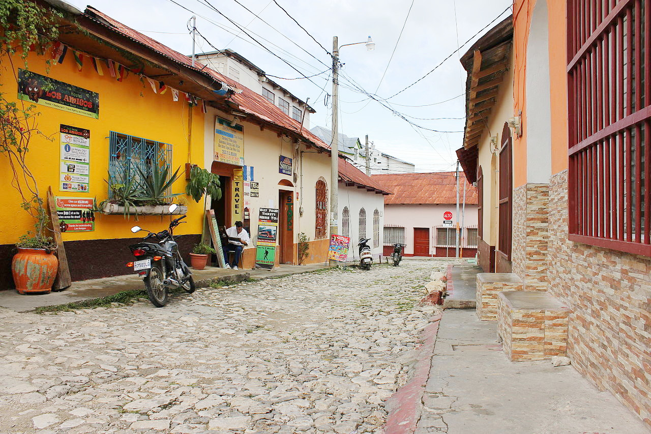
 Flores, Petén Department
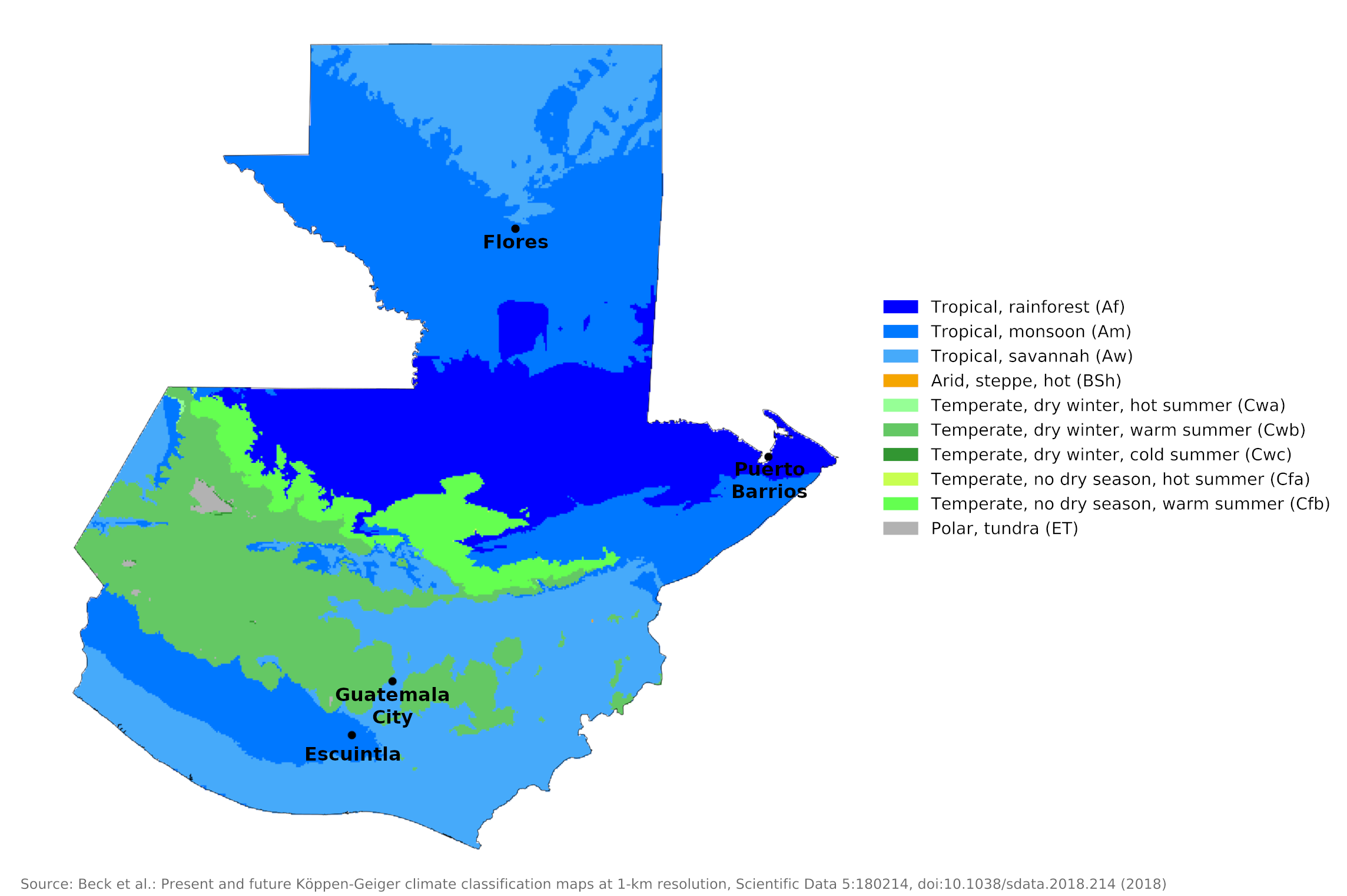
Climate Map
 Climate map of Guatemala
What is the climate of Guatemala like?
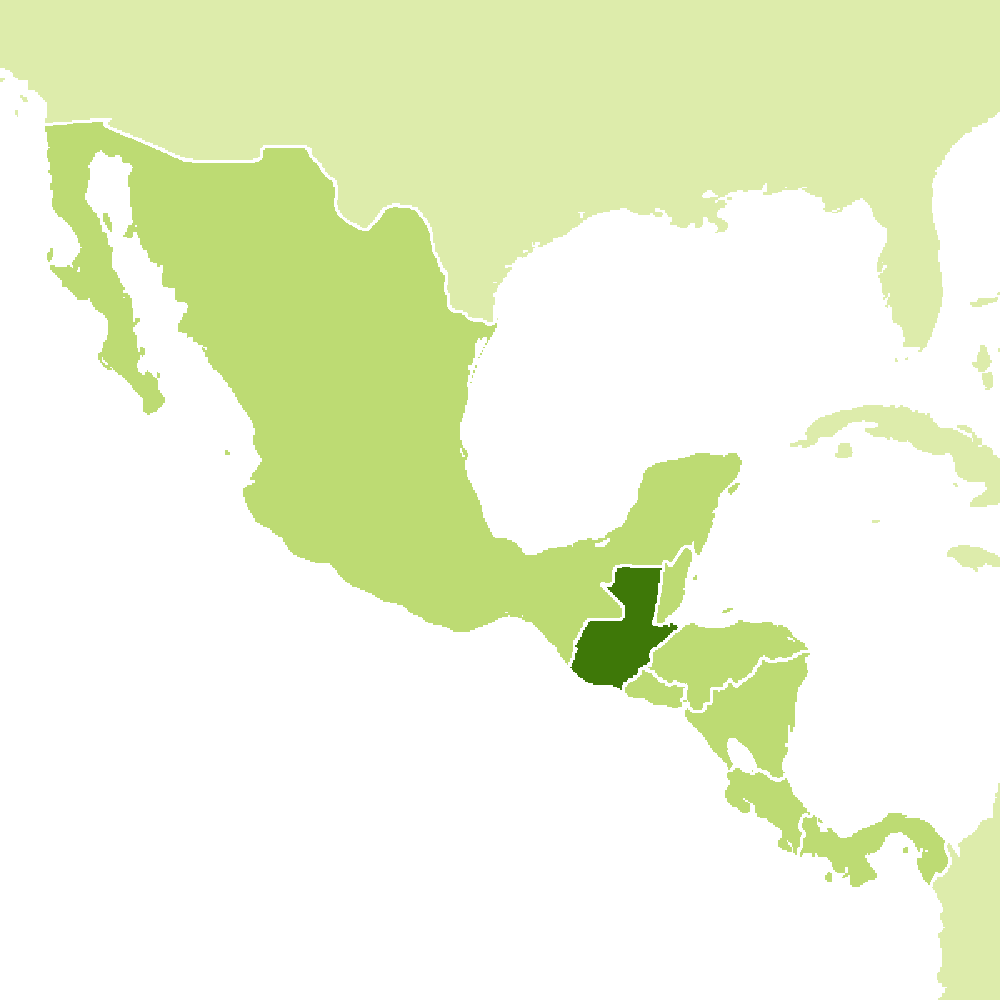
Guatemala is one of the larger countries of Central America whose weather and climate are described in more detail in the Panama pages. Lying between 14° and 18°N, Guatemala is bordered on the north by Mexico, on the east by Belize, and on the south by Honduras and El Salvador. It has a very short coastline on the Caribbean Sea and a longer west coast on the Pacific. In area it is about the size of the state of Pennsylvania and a little smaller than England.
The climate depends largely on the elevation, which ranges from sea level to nearly 4,200 meters (13,800 feet), and proximity to any of the coasts. The Tierra Caliente (hot land) extends from sea level to about 750 meters (2,450 feet); it has average daily temperatures of 29°C to 32°C (84–90°F). the temperate land of the Tierra Templada extends from 750 meters above sea level to about 1,600 meters (5,250 feet): daily temperatures average between 24°C and 27°C (75–81°F), and nighttime temperatures average between 16°C and 21°C (61–70°F). The Tierra Fría (cold land) extends over the 1,600 meter level and has daily averages of up to 26°C (79°F) and nighttime averages of 10 °C (50°F) and occasionally lower.
The prevailing winds are the rain-carrying northeast trade winds blowing inland from the Caribbean. As a result, wet conditions prevail in the northern lowlands, northern and eastern parts of the Highlands and the Caribbean coastal region for most of the year. The rest of the country has a distinct dry season from November to April, with the exception of a strip on the Pacific slope between 1,000 and 1,600 meters (3,300–5,250 feet) above sea level. There, the precipitation conditions are similar to those on the Caribbean coast. The dry season is called verano (summer) and the rainy season invierno (winter).
Pacific Coast
The coastal plain is predominantly savannah interspersed with forests that line the rivers. Farther inland, tropical forest covers the foothills and lower slopes of the Highlands. The temperatures are typical for the Tierra Caliente. Monsoon winds blowing from the Pacific bring heavy rains between May and October and a pronounced dry season from November to April. Rainfall on the Pacific Coast is quite heavy during the rainy season and there is little relief from the high temperatures at night.
Further inland the plains become a steeper, more dissected climb to the Highlands through the upper foothills 600 to 1,600 meters (2,000–5,250 feet) above sea level. Tropical deciduous forests once covered these upper slopes. Rainfall is heavy, especially in the western part, where it averages over 2,500 millimeters (100 inches) annually. The dry season is short and temperatures are slightly lower than on the coastal plain and lower foothills. Most of the country's high-quality coffee is grown in this area, where the volcanic soil, heavy rainfall and many shady trees under which the coffee plants grow provide near-ideal conditions.
| Climate data for Escuintla | |||||||||||||
|---|---|---|---|---|---|---|---|---|---|---|---|---|---|
| Month | Jan | Feb | Mar | Apr | May | Jun | Jul | Aug | Sep | Oct | Nov | Dec | Year |
| Average high °C (°F) | 31.9 (89.4) | 32.1 (89.8) | 33.4 (92.1) | 33.3 (91.9) | 32.5 (90.5) | 31.2 (88.2) | 31.5 (88.7) | 31.2 (88.2) | 30.2 (86.4) | 30.1 (86.2) | 30.4 (86.7) | 31.0 (87.8) | 31.6 (88.8) |
| Daily mean °C (°F) | 25.5 (77.9) | 25.7 (78.3) | 27.2 (81.0) | 27.3 (81.1) | 27.3 (81.1) | 26.5 (79.7) | 26.9 (80.4) | 26.7 (80.1) | 25.7 (78.3) | 25.2 (77.4) | 25.1 (77.2) | 25.1 (77.2) | 26.2 (79.1) |
| Average low °C (°F) | 19.2 (66.6) | 19.4 (66.9) | 21.0 (69.8) | 21.3 (70.3) | 22.2 (72.0) | 21.8 (71.2) | 22.3 (72.1) | 22.2 (72.0) | 21.3 (70.3) | 20.4 (68.7) | 19.8 (67.6) | 19.3 (66.7) | 20.9 (69.5) |
| Average precipitation mm (inches) | 7 (0.3) | 13 (0.5) | 30 (1.2) | 93 (3.7) | 333 (13.1) | 555 (21.9) | 337 (13.3) | 360 (14.2) | 581 (22.9) | 417 (16.4) | 85 (3.3) | 15 (0.6) | 2,826 (111.4) |
| Source: Climate-Data.org | |||||||||||||
Highlands
The central west and south of the country are very mountainous with some volcanic peaks rising to over 4,000 meters (13,000 feet). A large part of the hilly country is typical tierra templada, and the climatic conditions are well represented by the climate of Guatemala City, which has a very pleasant climate.In the central highlands the average is 20°C (68°F) all year round. In Guatemala City, the average January minimum is 13°C (56°F) and the maximum 24°C (76°F); the average minimum and maximum temperatures in July are 16°C (61°F) and 26°C (78°F).
Because of its consistently temperate climate, Guatemala has been called the "Land of Eternal Spring." Rainfall in the highlands is moderate with a distinct dry season from November to April. The rainy season lasts from May through October. Northern and eastern parts of the highlands have humid conditions for most of the year.
| Climate data for Guatemala City (1990-2011) | |||||||||||||
|---|---|---|---|---|---|---|---|---|---|---|---|---|---|
| Month | Jan | Feb | Mar | Apr | May | Jun | Jul | Aug | Sep | Oct | Nov | Dec | Year |
| Average high °C (°F) | 24.3 (75.7) | 25.8 (78.4) | 26.8 (80.2) | 27.8 (82.0) | 27.1 (80.8) | 25.8 (78.4) | 25.4 (77.7) | 25.5 (77.9) | 25.1 (77.2) | 24.7 (76.5) | 24.2 (75.6) | 23.9 (75.0) | 25.5 (77.9) |
| Daily mean °C (°F) | 18.7 (65.7) | 19.7 (67.5) | 20.7 (69.3) | 21.9 (71.4) | 21.9 (71.4) | 21.3 (70.3) | 20.8 (69.4) | 21.0 (69.8) | 20.7 (69.3) | 20.3 (68.5) | 19.4 (66.9) | 18.8 (65.8) | 20.4 (68.7) |
| Average low °C (°F) | 13.2 (55.8) | 13.6 (56.5) | 14.6 (58.3) | 16.0 (60.8) | 16.8 (62.2) | 16.8 (62.2) | 16.3 (61.3) | 16.5 (61.7) | 16.4 (61.5) | 16.0 (60.8) | 14.7 (58.5) | 13.7 (56.7) | 15.4 (59.7) |
| Average precipitation mm (inches) | 2.8 (0.11) | 5.4 (0.21) | 6.0 (0.24) | 31.0 (1.22) | 128.9 (5.07) | 271.8 (10.70) | 202.6 (7.98) | 202.7 (7.98) | 236.6 (9.31) | 131.6 (5.18) | 48.8 (1.92) | 6.6 (0.26) | 1,274.8 (50.18) |
| Source: Instituto Nacional de Sismologia, Vulcanologia, Meteorologia e Hidrología | |||||||||||||
Caribbean Coast
The climate of the Caribbean coast, including the valleys that extend inland, is humid and tropical: there is no distinct dry season other than a reduction in rainfall between February and May. At Puerto Barrios the monthly temperature averages range from about 24°C (76°F) in December to over 29°C (84°F) in May. Tropical rain forest of broadleaf evergreen trees covers much of the area except where modern plantations have been established.
| Climate data for Puerto Barrios (1991-2010) | |||||||||||||
|---|---|---|---|---|---|---|---|---|---|---|---|---|---|
| Month | Jan | Feb | Mar | Apr | May | Jun | Jul | Aug | Sep | Oct | Nov | Dec | Year |
| Average high °C (°F) | 27.7 (81.9) | 28.8 (83.8) | 30.3 (86.5) | 31.7 (89.1) | 32.4 (90.3) | 32.4 (90.3) | 31.7 (89.1) | 31.8 (89.2) | 32.1 (89.8) | 30.7 (87.3) | 28.7 (83.7) | 27.6 (81.7) | 30.5 (86.9) |
| Daily mean °C (°F) | 23.6 (74.5) | 24.5 (76.1) | 25.7 (78.3) | 27.4 (81.3) | 28.3 (82.9) | 28.6 (83.5) | 28.0 (82.4) | 27.9 (82.2) | 27.8 (82.0) | 26.7 (80.1) | 25.0 (77.0) | 23.9 (75.0) | 26.5 (79.7) |
| Average low °C (°F) | 19.8 (67.6) | 20.2 (68.4) | 21.0 (69.8) | 22.5 (72.5) | 23.5 (74.3) | 23.7 (74.7) | 23.1 (73.6) | 23.4 (74.1) | 23.5 (74.3) | 22.9 (73.2) | 21.2 (70.2) | 20.3 (68.5) | 22.1 (71.8) |
| Average precipitation mm (inches) | 292.1 (11.50) | 161.1 (6.34) | 145.8 (5.74) | 159.6 (6.28) | 195.6 (7.70) | 243.2 (9.57) | 438.7 (17.27) | 390.4 (15.37) | 336.5 (13.25) | 368.5 (14.51) | 397.8 (15.66) | 304.4 (11.98) | 3,373.7 (132.82) |
| Source: Instituto Nacional de Sismología, Vulcanología Meteorología e Hidrología | |||||||||||||
The North
The large geographic region of the north, El Petén, is a low plain and forms part of the tierra caliente. It an area of typical hot, tropical climate with some rain all the year round and maximum rainfall between May and September. Conditions are drier in the north, but rainfall increases towards the south.| Climate data for Flores | |||||||||||||
|---|---|---|---|---|---|---|---|---|---|---|---|---|---|
| Month | Jan | Feb | Mar | Apr | May | Jun | Jul | Aug | Sep | Oct | Nov | Dec | Year |
| Average high °C (°F) | 26.9 (80.4) | 27.6 (81.7) | 28.9 (84.0) | 30.6 (87.1) | 32.4 (90.3) | 32.5 (90.5) | 31.0 (87.8) | 31.2 (88.2) | 30.7 (87.3) | 29.0 (84.2) | 27.4 (81.3) | 26.7 (80.1) | 29.6 (85.2) |
| Daily mean °C (°F) | 22.8 (73.0) | 23.3 (73.9) | 24.7 (76.5) | 26.3 (79.3) | 28.1 (82.6) | 28.4 (83.1) | 27.1 (80.8) | 27.2 (81.0) | 26.8 (80.2) | 25.2 (77.4) | 23.4 (74.1) | 22.5 (72.5) | 25.5 (77.9) |
| Average low °C (°F) | 18.8 (65.8) | 19.0 (66.2) | 20.5 (68.9) | 22.1 (71.8) | 23.8 (74.8) | 24.4 (75.9) | 23.2 (73.8) | 23.2 (73.8) | 22.9 (73.2) | 21.4 (70.5) | 19.4 (66.9) | 18.4 (65.1) | 21.4 (70.6) |
| Average precipitation mm (inches) | 66 (2.6) | 55 (2.2) | 43 (1.7) | 34 (1.3) | 136 (5.4) | 209 (8.2) | 187 (7.4) | 183 (7.2) | 227 (8.9) | 208 (8.2) | 115 (4.5) | 87 (3.4) | 1,550 (61) |
| Source: Climate-Data.org | |||||||||||||
References
- E. A. Pearce, Charles Gordon Smith, (1990) The Hutchinson World Weather Guide, John Murray Press. ISBN 1859863426
- Timothy L. Gall, (ed.), (2003), Worldmark Encyclopedia of the Nations, Eleventh Edition, Thomson Gale
- Federal Research Division, Library of Congress, (1983), Guatemala: a country study. Claitor's Pub. Division.
- Hugh Chisholm, (ed.), (1911), Encyclopædia Britannica, Eleventh edition, Cambridge University Press
The Climate of
Guatemala

In summary:
The climate ranges from hot and humid in parts of the lowlands to very cold in the highlands, where frosts are common in some months and snow falls occasionally. Average annual temperatures at the coast range from 25°C to 30°C (77°F to 86°F); in the central highlands, they average 20°C (68°F); and in the higher mountain areas, they average 11°C (59°F).
The rainy season lasts from May through October inland, and into December along the coast; the dry season thus extends from November (or January) to April.