The Climate of
The Democratic Republic of the Congo
.jpg) Kahuzi-Biega National Park
Kahuzi-Biega National Park
.jpg&oldid=655640459)
Climate Map
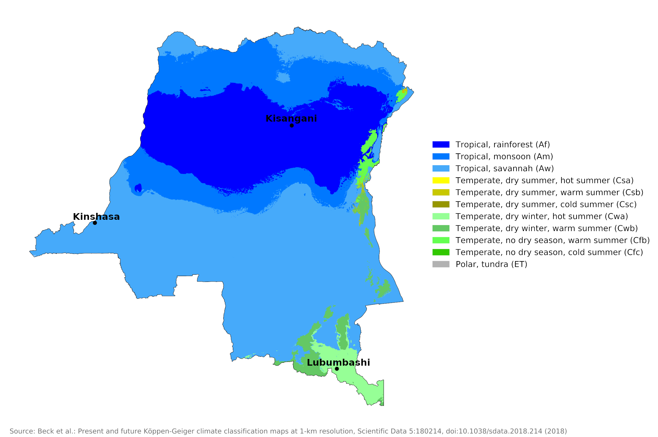 Climate map of the Democratic Republic of the Congo
What is the climate of The Democratic Republic of the Congo like?
The Democratic Republic of the Congo is the largest country in Central Africa. It is almost entirely landlocked, with only a very short stretch of coastline on the Atlantic Ocean around the Congo Estuary, between the Republic of the Congo and Angola. With the exception of the eastern mountains, the region has an equatorial or tropical climate. In the northern part of the region, roughly between 4°N and the equator, it rains year-round with two periods when rain is heaviest and most likely. South of this equatorial area of precipitation are areas where high sun precipitation is concentrated in a single rainy season; there is a pronounced dry season when the sun is low in the sky.
In this region, temperatures remain high all year round. At lower levels near the equator, temperatures rarely fall below 18°C (64°F), even at night. However, daily highs rarely rise above 35°C (95°F). Humidity remains high year-round, rarely dropping very low during the hottest part of the day, leaving the weather feeling muggy and oppressive most of the time. Except for the occasional gust of thunder, winds are light, making the temperature feel higher than the thermometer suggests. In areas with a pronounced dry season, temperatures rise somewhat higher during the day; Humidity is also lower at this time and these higher temperatures may not feel as oppressive as the lower temperatures during the rainy season when there is higher humidity, lots of cloud and little sunshine.
In the southern highlands, particularly the southeast, winters are cool and dry while summers are warm and humid. The area around the chain of lakes from Lake Albert to Lake Tanganyika in the eastern highlands has a humid climate and a narrow but not overly hot temperature range. The mountain sections are cooler, but humidity increases with altitude until the saturation point is reached; On some slopes, especially in the Rwenzori mountains on the Uganda border, there is an almost constant mist.
The small coastal area is affected by the same relative aridity that is typical of the coast of Angola. Precipitation increases inland. Kisangani represents the weather and climate of much of central Congo.
| Climate data for Kisangani | |||||||||||||
|---|---|---|---|---|---|---|---|---|---|---|---|---|---|
| Month | Jan | Feb | Mar | Apr | May | Jun | Jul | Aug | Sep | Oct | Nov | Dec | Year |
| Average high °C (°F) | 31 (88) | 31 (88) | 31 (88) | 31 (88) | 31 (88) | 30 (86) | 29 (84) | 28 (82) | 29 (84) | 30 (86) | 29 (84) | 30 (86) | 30.0 (86.0) |
| Daily mean °C (°F) | 26 (79) | 26 (79) | 26 (79) | 26 (79) | 26 (79) | 25.5 (77.9) | 24 (75) | 24 (75) | 24.5 (76.1) | 25 (77) | 24.5 (76.1) | 25 (77) | 25.2 (77.4) |
| Average low °C (°F) | 21 (70) | 21 (70) | 21 (70) | 21 (70) | 21 (70) | 21 (70) | 19 (66) | 20 (68) | 20 (68) | 20 (68) | 20 (68) | 20 (68) | 20.4 (68.7) |
| Average precipitation mm (inches) | 53 (2.1) | 84 (3.3) | 178 (7.0) | 158 (6.2) | 137 (5.4) | 114 (4.5) | 132 (5.2) | 165 (6.5) | 183 (7.2) | 218 (8.6) | 198 (7.8) | 84 (3.3) | 1,620 (63.8) |
| Source: BBC Weather Centre Kisangani | |||||||||||||
Kinshasa at 4°S shows a precipitation distribution over the year that is more typical for the districts south of the equator; there is a single long rainy season with a short dry season from June to September when the sun is north of the equator.
| Climate data for Kinshasa | |||||||||||||
|---|---|---|---|---|---|---|---|---|---|---|---|---|---|
| Month | Jan | Feb | Mar | Apr | May | Jun | Jul | Aug | Sep | Oct | Nov | Dec | Year |
| Average high °C (°F) | 30.6 (87.1) | 31.3 (88.3) | 32.0 (89.6) | 32.0 (89.6) | 31.1 (88.0) | 28.8 (83.8) | 27.3 (81.1) | 28.9 (84.0) | 30.6 (87.1) | 31.1 (88.0) | 30.6 (87.1) | 30.1 (86.2) | 30.4 (86.7) |
| Daily mean °C (°F) | 25.9 (78.6) | 26.4 (79.5) | 26.8 (80.2) | 26.9 (80.4) | 26.3 (79.3) | 24.0 (75.2) | 22.5 (72.5) | 23.7 (74.7) | 25.4 (77.7) | 26.2 (79.2) | 26.0 (78.8) | 25.6 (78.1) | 25.5 (77.9) |
| Average low °C (°F) | 21.2 (70.2) | 21.6 (70.9) | 21.6 (70.9) | 21.8 (71.2) | 21.6 (70.9) | 19.3 (66.7) | 17.7 (63.9) | 18.5 (65.3) | 20.2 (68.4) | 21.3 (70.3) | 21.5 (70.7) | 21.2 (70.2) | 20.6 (69.1) |
| Average precipitation mm (inches) | 163 (6.4) | 165 (6.5) | 221 (8.7) | 238 (9.4) | 142 (5.6) | 9 (0.4) | 5 (0.2) | 2 (0.1) | 49 (1.9) | 98 (3.9) | 247 (9.7) | 143 (5.6) | 1,482 (58.4) |
| Source: Climate-Data.org | |||||||||||||
Located in the southeast at an elevation of 1,200 meters (3,950 feet), Lubumbashi experiences a prolonged dry season between May and October, during which nighttime temperatures are much lower than elsewhere. There is a little more sunshine here, especially in the dry season. During the rainy season, there is less rainfall, so the climate is closer to that of neighboring Zambia and Angola. Here, the average number of hours of sunshine per day ranges from four to five in the rainy season to nine to ten in the dry season. This is more variation and a greater number of hours of sunshine per year than almost anywhere else in Congo and much more than the consistently wet regions.
| Climate data for Lubumbashi | |||||||||||||
|---|---|---|---|---|---|---|---|---|---|---|---|---|---|
| Month | Jan | Feb | Mar | Apr | May | Jun | Jul | Aug | Sep | Oct | Nov | Dec | Year |
| Average high °C (°F) | 26 (79) | 26 (79) | 26 (79) | 27 (81) | 26 (79) | 25 (77) | 25 (77) | 27 (81) | 30 (86) | 31 (88) | 28 (82) | 26 (79) | 27 (81) |
| Daily mean °C (°F) | 21 (70) | 21 (70) | 21 (70) | 20.5 (68.9) | 18 (64) | 16.5 (61.7) | 16.5 (61.7) | 18 (64) | 21 (70) | 23 (73) | 22 (72) | 21 (70) | 20.0 (67.9) |
| Average low °C (°F) | 16 (61) | 16 (61) | 16 (61) | 14 (57) | 10 (50) | 8 (46) | 8 (46) | 9 (48) | 12 (54) | 15 (59) | 16 (61) | 16 (61) | 13 (55) |
| Average precipitation mm (inches) | 253 (10.0) | 257 (10.1) | 202 (8.0) | 60 (2.4) | 4 (0.2) | 1 (0.0) | 0 (0) | 0 (0) | 4 (0.2) | 37 (1.5) | 163 (6.4) | 257 (10.1) | 1,238 (48.9) |
| Source: www.weather2travel.com | |||||||||||||
The seasonal pattern of rainfall is affected by the country's position on the equator. In the third of the country that lies north of the equator, the dry season (roughly early November to late March) corresponds to the rainy season in the southern two-thirds. There is a great deal of variation, however, and a number of places on either side of the equator have two wet and two dry seasons.
Rainfall averages range from about 1,000 millimeters to 2,200 millimeters (40–88 inches). Annual rainfall is highest in the heart of the Congo River basin and in the eastern highlands and with some variation tends to diminish away from these areas. Rainfall is lightest on the coast near the mouth of the Congo River and on the extreme southern edges of the region. The southeastern highlands is the only area marked by long four-month to five-month dry seasons and occasional droughts occur here.
References
- E. A. Pearce, Charles Gordon Smith, (1990) The Hutchinson World Weather Guide, John Murray Press. ISBN 1859863426
- Timothy L. Gall, (ed.), (2003), Worldmark Encyclopedia of the Nations, Eleventh Edition, Thomson Gale
- Federal Research Division, Library of Congress, (1994), Zaire: a country study. Claitor's Pub. Division. ISBN 0844407595X
- Hugh Chisholm, (ed.), (1911), Encyclopædia Britannica, Eleventh edition, Cambridge University Press
The Climate of
The Democratic Republic of the Congo
In summary:
The climate is tropical, with temperatures that vary depending on elevation and latitude. In the equator region, it is hot and very humid and the temperature does not go below 20°C (68°F). It is cooler and less humid in the southern highlands and cooler and wetter in the eastern highlands and mountains. The average temperature in the central region is around 25°C (77°F).
The annual rainfall ranges from 1,200 to 2,000 mm (48 to 80 in). In the north of the country there are two rainy seasons and two dry seasons in each year. To the south there are districts where rainfall is concentrated into a single rainy season at the time of high sun.