The Climate of
Ecuador
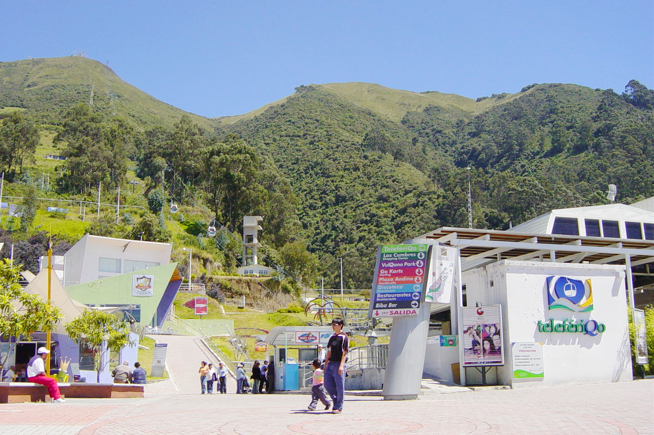 TeleferiQo gondola lift, Quito
Climate Map
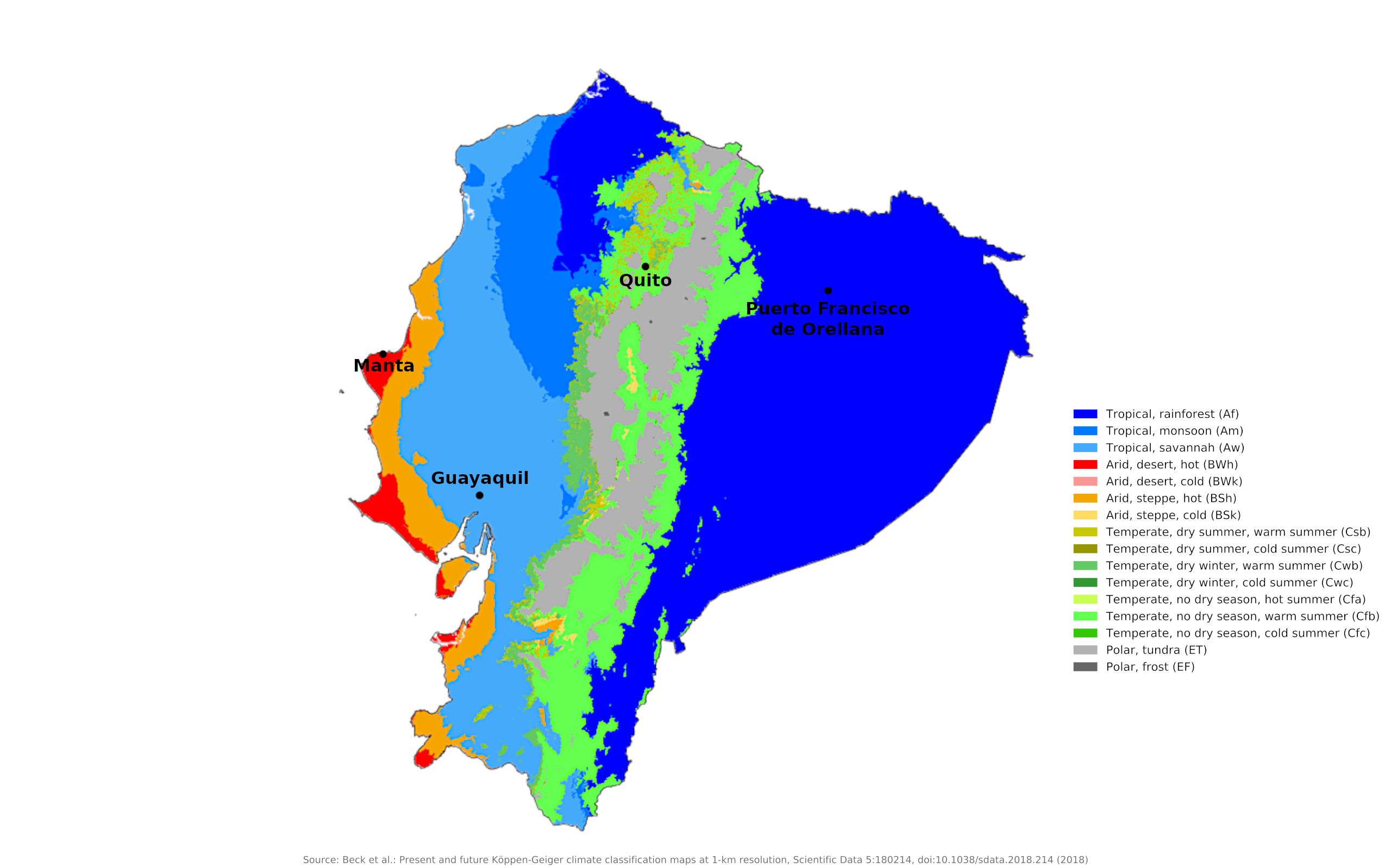 Climate map of Ecuador
What is the climate of Ecuador like?
Ecuador is, as the name suggests, on the equator between 1°N and 5°S on the west coast of South America. It borders Colombia on the north, and Peru on the east and south. Ecuador is a small country, slightly larger than the United Kingdom and about the size of the state of Arizona. Mainland Ecuador includes three distinctive climatic regions: a narrow coastal plain, a high mountainous central region with the main Andean mountain ranges, and a forested lowland region to the east that is part of the Amazon Basin. The Galapagos Islands, 1,050 km (650 mi) west of the coast of Ecuador, form a fourth climate region.
Ecuador generally has a tropical climate, but there are major differences between regions. The cold Peruvian Current in the Pacific Ocean keeps the coastal region cool with temperatures ranging from 25° to 31°C (76° to 90°F). In the mountainous region of the Andes, temperatures depend on altitude, with cooler temperatures at higher elevations; The temperature can vary greatly throughout the day. The highest mountains are covered with snow all year round. The eastern region typically has a warm, humid, and rainy climate. The average temperature varies between 23°C and 26°C (72°F to 80°F). The amount of precipitation can vary greatly in Ecuador. The country sometimes has periods of drought; at other times, heavy rains can cause flooding.
Throughout Ecuador, fluctuations in rainfall mainly determine the seasons. The temperature is determined by the altitude. For every increase of 200 meters in altitude, the temperature drops by 1°C. This phenomenon is particularly pronounced in the mountains.
Coastal Ecuador
Much of the coast of Ecuador, particularly in the south, is an arid or even desert region. Inland, however, the coastal plain becomes humid and forested. Manta and Guayaquil show this difference in the climate of the coastal areas of Ecuador. The heat is modified in many parts of the coast by the cold Humboldt Current sweeping up the west coast of South America from the Antarctic seas. Although seasonal changes in temperature are not pronounced, the hottest period occurs during the rainy season, especially from February to April.
Rainfall in the Costa decreases from north to south, with vegetation changing from tropical rainforest in the north to tropical savannah to desert in the south. There is a single main rainy season from December to April and a dry season from May to November. The two seasons are sometimes interrupted by clear skies in winter and a drizzle called "garua" in summer. Inland, the region is humid tropical rainforest, becoming wetter to the north. Heading north, total annual precipitation increases to 2,000 millimeters (80 inches) or more, with some rain falling in all months. This is a typical equatorial precipitation pattern. However, in the southern coastal districts, rainfall decreases sharply, dropping to just 200 millimeters (8 inches) per year as you approach Peru's arid coastal belt.
Differences in temperature and precipitation on the coast are caused by the Humboldt Current and the periodic El Nino phenomena. The Humboldt Current, also known as the Peruvian Current, is a cold ocean current that flows north along the coasts of Chile and Peru. The cold water and air temperatures associated with the Humboldt Current prevent precipitation along the coast, creating dry to arid conditions. This effect is greatest along the southern coast of Ecuador.
El Nino occurs periodically every six or seven years. Beginning in late December, a change in atmospheric pressure shifts ocean currents, allowing warm water to move closer to shore, displacing cold water. During this time, air and water temperatures, tides, sea levels and wave heights, and relative humidity are higher than usual. These conditions result in heavy rains that typically last through May in an area that typically sees only drizzle. The consequences can be floods and landslides.
| Climate data for Manta | |||||||||||||
|---|---|---|---|---|---|---|---|---|---|---|---|---|---|
| Month | Jan | Feb | Mar | Apr | May | Jun | Jul | Aug | Sep | Oct | Nov | Dec | Year |
| Average high °C (°F) | 30.0 (86.0) | 30.0 (86.0) | 30.6 (87.1) | 30.6 (87.1) | 30.6 (87.1) | 29.4 (84.9) | 28.9 (84.0) | 29.4 (84.9) | 28.9 (84.0) | 28.9 (84.0) | 29.4 (84.9) | 29.4 (84.9) | 29.7 (85.4) |
| Daily mean °C (°F) | 26.1 (79.0) | 26.1 (79.0) | 26.4 (79.5) | 26.4 (79.5) | 26.15 (79.07) | 25.25 (77.45) | 24.75 (76.55) | 24.7 (76.5) | 24.45 (76.01) | 24.45 (76.01) | 25 (77) | 25.25 (77.45) | 25.42 (77.75) |
| Average low °C (°F) | 22.2 (72.0) | 22.2 (72.0) | 22.2 (72.0) | 22.2 (72.0) | 21.7 (71.1) | 21.1 (70.0) | 20.6 (69.1) | 20.0 (68.0) | 20.0 (68.0) | 20.0 (68.0) | 20.6 (69.1) | 21.1 (70.0) | 21.2 (70.1) |
| Average precipitation mm (inches) | 40.6 (1.60) | 96.5 (3.80) | 68.6 (2.70) | 25.4 (1.00) | 2.5 (0.10) | 5.1 (0.20) | 5.1 (0.20) | 0.8 (0.03) | 0.8 (0.03) | 0.8 (0.03) | 2.5 (0.10) | 5.1 (0.20) | 253.8 (9.99) |
| Source: Sistema de Clasificación Bioclimática Mundial | |||||||||||||
| Climate data for Guayaquil | |||||||||||||
|---|---|---|---|---|---|---|---|---|---|---|---|---|---|
| Month | Jan | Feb | Mar | Apr | May | Jun | Jul | Aug | Sep | Oct | Nov | Dec | Year |
| Average high °C (°F) | 31.2 (88.2) | 31.2 (88.2) | 32.2 (90.0) | 32.0 (89.6) | 31.2 (88.2) | 29.8 (85.6) | 29.1 (84.4) | 29.7 (85.5) | 30.5 (86.9) | 30.2 (86.4) | 31.1 (88.0) | 31.8 (89.2) | 30.8 (87.4) |
| Daily mean °C (°F) | 27.1 (80.8) | 27.3 (81.1) | 28.0 (82.4) | 27.8 (82.0) | 26.9 (80.4) | 25.7 (78.3) | 25.0 (77.0) | 25.2 (77.4) | 25.5 (77.9) | 25.6 (78.1) | 26.2 (79.2) | 27.1 (80.8) | 26.5 (79.7) |
| Average low °C (°F) | 23.0 (73.4) | 23.4 (74.1) | 23.7 (74.7) | 23.5 (74.3) | 22.6 (72.7) | 21.5 (70.7) | 20.8 (69.4) | 20.7 (69.3) | 20.5 (68.9) | 20.9 (69.6) | 21.3 (70.3) | 22.4 (72.3) | 22.0 (71.6) |
| Average precipitation mm (inches) | 200.7 (7.90) | 332.0 (13.07) | 315.7 (12.43) | 207.7 (8.18) | 62.6 (2.46) | 34.0 (1.34) | 15.6 (0.61) | 1.2 (0.05) | 1.5 (0.06) | 5.6 (0.22) | 29.1 (1.15) | 68.0 (2.68) | 1,263.2 (49.73) |
| Source: World Meteorological Organization | |||||||||||||
Andean Ecuador
In the central mountainous region of the Andes, temperatures are greatly reduced depending on the altitude and the region can be divided into hot, temperate and cold zones (tierra caliente, tierra templada , and tierra fria). Due to heavier rainfall in Ecuador compared to Peru and Bolivia, the snow line is at an altitude of about 5,000 meters (16,000 feet). The health effect of altitude at elevations above 3,000 meters (10,000 feet) is something the visitor should consider.
Quito in the Ecuadorian Andes region is celebrated for its pleasant temperatures, with little temperature variation throughout the year. Daily temperatures, however, vary dramatically, from cold mornings to hot afternoons. The almost vertical sun and the rarified air in the higher Sierra region allow the land to warm quickly during the day and lose heat quickly at night. Mornings typically are bright and sunny, whereas afternoons often are cloudy and rainy.
In general, rainfall amounts are highest on exposed locations at lower altitudes. Rain also can vary on a local basis. Sheltered valleys normally receive 500 millimeters per year (20 inches), whereas annual rainfall is 1000 millimeters (40 inches) in Quito and can reach 2,500 centimeters (100 inches) on exposed slopes that catch rain-bearing winds. On a seasonal basis, the driest months are June through September.
Much of the precipitation in this mountainous region falls in the afternoon and evening, when clouds gather over the mountains and thunderstorms gather. Sunshine hours in Quito are lowest during the wet season, when it averages four to five a day, and greatest during the dry season, when there are seven to eight. In general, the rainfall and vegetation that characterize the Quito Basin soon disappear as one advances south, and are replaced by drier conditions.
The highlands are intersected by numerous deep valleys that bring the subtropical climate within a few kilometers of the more temperate areas. Cold and wind increase while the slopes around the central plateau rise, forming the 'páramo' or highland meadow. The higher areas rise to peaks over 5,200 meters (17,000 feet) that are perpetually blanketed in snow.
At higher altitudes, even on the same mountain, there are big differences in snowfall and in the intensity of the cold. The limit of permanent snow is much higher on the plateau side in both mountain ranges, snowfall is heavier on the outer sides—those facing the forested lowlands.
| Climate data for Quito | |||||||||||||
|---|---|---|---|---|---|---|---|---|---|---|---|---|---|
| Month | Jan | Feb | Mar | Apr | May | Jun | Jul | Aug | Sep | Oct | Nov | Dec | Year |
| Average high °C (°F) | 21.2 (70.2) | 21.0 (69.8) | 20.8 (69.4) | 20.9 (69.6) | 21.0 (69.8) | 21.1 (70.0) | 21.5 (70.7) | 22.2 (72.0) | 22.3 (72.1) | 21.8 (71.2) | 21.3 (70.3) | 21.3 (70.3) | 21.4 (70.5) |
| Daily mean °C (°F) | 15.5 (59.9) | 15.6 (60.1) | 15.5 (59.9) | 15.6 (60.1) | 15.6 (60.1) | 15.5 (59.9) | 15.5 (59.9) | 15.9 (60.6) | 15.9 (60.6) | 15.7 (60.3) | 15.5 (59.9) | 15.5 (59.9) | 15.6 (60.1) |
| Average low °C (°F) | 9.8 (49.6) | 10.1 (50.2) | 10.1 (50.2) | 10.2 (50.4) | 10.1 (50.2) | 9.8 (49.6) | 9.4 (48.9) | 9.6 (49.3) | 9.4 (48.9) | 9.5 (49.1) | 9.6 (49.3) | 9.7 (49.5) | 9.8 (49.6) |
| Average precipitation mm (inches) | 82.5 (3.25) | 111.0 (4.37) | 146.6 (5.77) | 171.2 (6.74) | 105.5 (4.15) | 39.5 (1.56) | 21.5 (0.85) | 27.7 (1.09) | 68.9 (2.71) | 114.9 (4.52) | 108.5 (4.27) | 100.4 (3.95) | 1,098.2 (43.24) |
| Source: World Meteorological Organization | |||||||||||||
Eastern Ecuador
The eastern part of the country, the Oriente, at the foot of the Andes, is low-lying and has a typically hot, wet, equatorial climate with well-distributed rainfall throughout the year. Rainfall is abundant, especially in the foothills, sometimes exceeding 5,000 millimeters (200 inches) per year. Temperatures average 25°C (77°F) in the western parts of this region. The jungle-covered plains of the Eastern lowlands resemble the Amazon rainforest in Brazil; here there are high levels of rainfall and temperatures surpassing 28°C (82°F).
| Climate data for Puerto Francisco de Orellana | |||||||||||||
|---|---|---|---|---|---|---|---|---|---|---|---|---|---|
| Month | Jan | Feb | Mar | Apr | May | Jun | Jul | Aug | Sep | Oct | Nov | Dec | Year |
| Average high °C (°F) | 29.9 (85.8) | 30.0 (86.0) | 29.7 (85.5) | 29.3 (84.7) | 29.0 (84.2) | 28.6 (83.5) | 28.5 (83.3) | 29.6 (85.3) | 30.2 (86.4) | 30.4 (86.7) | 30.5 (86.9) | 30.5 (86.9) | 29.7 (85.4) |
| Daily mean °C (°F) | 24.8 (76.6) | 25.0 (77.0) | 24.9 (76.8) | 24.7 (76.5) | 24.4 (75.9) | 24.1 (75.4) | 24.0 (75.2) | 24.5 (76.1) | 25.0 (77.0) | 25.1 (77.2) | 25.4 (77.7) | 25.3 (77.5) | 24.8 (76.6) |
| Average low °C (°F) | 19.8 (67.6) | 20.0 (68.0) | 20.1 (68.2) | 20.1 (68.2) | 19.9 (67.8) | 19.7 (67.5) | 19.5 (67.1) | 19.4 (66.9) | 19.8 (67.6) | 19.9 (67.8) | 20.3 (68.5) | 20.1 (68.2) | 19.9 (67.8) |
| Average precipitation mm (inches) | 243 (9.6) | 279 (11.0) | 235 (9.3) | 374 (14.7) | 329 (13.0) | 293 (11.5) | 241 (9.5) | 185 (7.3) | 252 (9.9) | 308 (12.1) | 309 (12.2) | 271 (10.7) | 3,319 (130.8) |
| Source: Climate-Data.org | |||||||||||||
References
- E. A. Pearce, Charles Gordon Smith, (1990) The Hutchinson World Weather Guide, John Murray Press. ISBN 1859863426
- Timothy L. Gall, (ed.), (2003), Worldmark Encyclopedia of the Nations, Eleventh Edition, Thomson Gale
- Federal Research Division, Library of Congress, (1991), Ecuador: a country study. Claitor's Pub. Division. ISBN 0844407595X
- Hugh Chisholm, (ed.), (1911), Encyclopædia Britannica, Eleventh edition, Cambridge University Press
The Climate of
Ecuador
In summary:
Ecuador has a generally tropical climate, which varies between regions. The Coastal region has temperatures ranging from 25° to 31°C (76° to 90°F). In the Andean mountain region, temperatures depend on altitude, with cooler temperatures at higher altitudes; the temperature can vary greatly over the course of the day. The highest mountains are snow-covered year-round. The Eastern region normally has a hot, humid, and rainy climate. The average temperature there varies from 23°C to 26°C (72°F to 80°F).
Rainfall can vary greatly in Ecuador. The country sometimes has periods of drought; at other times, heavy rainfall. The southern part of the mountain region generally has heavy rainfall, with rainfall decreasing with altitude. Both the mountains and the coast get most of their rain between December and June. The eastern region is rainy year-round.