The Climate of
Eritrea
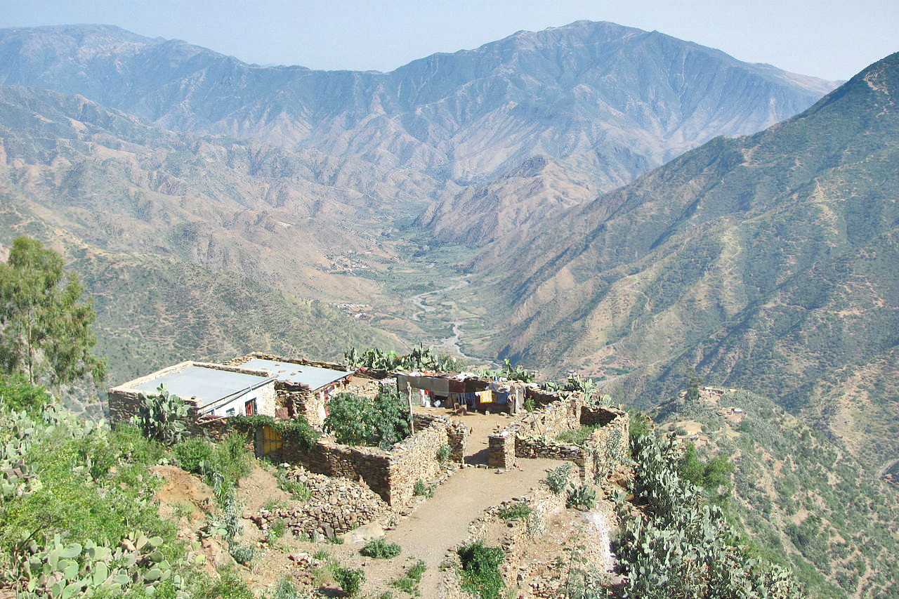 Mountain village near Asmara
Climate Map
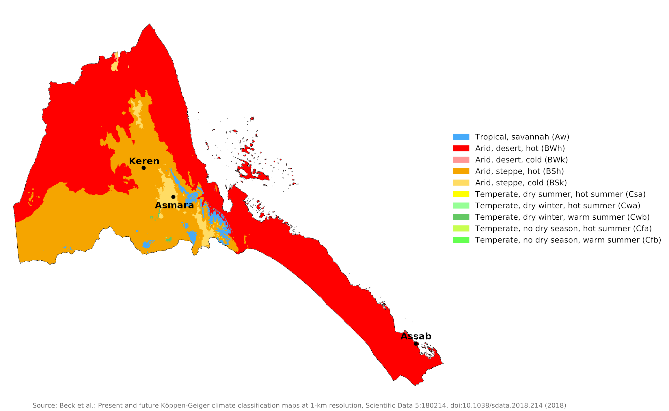 Climate map of Eritrea
What is the climate of Eritrea like?
Eritrea is situated on the Red Sea coast between the Sudan in the northwest and Djibouti in the southeast. Ethiopia borders it on the south.
To the west of the coastal plain rises an inland plateau, the most densely populated region of the country. The climate here is moderate, with temperatures that average about 17°C (63°F). There are cool breezes, around 500 millimeters (20 inches) of rainfall annually, almost constant sunshine, and only a small change in seasonal temperature. There is a monsoonal wet season which peaks in July and August and a dry season from December to February when very little rain falls.
| Climate data for Asmara (1961–1990) | |||||||||||||
|---|---|---|---|---|---|---|---|---|---|---|---|---|---|
| Month | Jan | Feb | Mar | Apr | May | Jun | Jul | Aug | Sep | Oct | Nov | Dec | Year |
| Average high °C (°F) | 22.3 (72.1) | 23.8 (74.8) | 25.1 (77.2) | 25.1 (77.2) | 25.0 (77.0) | 24.9 (76.8) | 21.6 (70.9) | 21.5 (70.7) | 22.9 (73.2) | 21.7 (71.1) | 21.5 (70.7) | 21.5 (70.7) | 23.1 (73.6) |
| Daily mean °C (°F) | 13.8 (56.8) | 14.9 (58.8) | 16.3 (61.3) | 17.0 (62.6) | 17.6 (63.7) | 17.6 (63.7) | 16.3 (61.3) | 16.1 (61.0) | 15.7 (60.3) | 14.9 (58.8) | 14.0 (57.2) | 13.2 (55.8) | 15.6 (60.1) |
| Average low °C (°F) | 4.3 (39.7) | 5.1 (41.2) | 7.5 (45.5) | 8.7 (47.7) | 10.2 (50.4) | 10.5 (50.9) | 10.8 (51.4) | 10.7 (51.3) | 8.6 (47.5) | 8.1 (46.6) | 6.6 (43.9) | 4.8 (40.6) | 8.0 (46.4) |
| Average precipitation mm (inches) | 3.7 (0.15) | 2.0 (0.08) | 14.6 (0.57) | 33.4 (1.31) | 41.1 (1.62) | 38.5 (1.52) | 174.9 (6.89) | 155.6 (6.13) | 15.6 (0.61) | 15.4 (0.61) | 20.4 (0.80) | 3.4 (0.13) | 518.6 (20.42) |
| Source: NOAA | |||||||||||||
| Climate data for Keren | |||||||||||||
|---|---|---|---|---|---|---|---|---|---|---|---|---|---|
| Month | Jan | Feb | Mar | Apr | May | Jun | Jul | Aug | Sep | Oct | Nov | Dec | Year |
| Average high °C (°F) | 28.4 (83.1) | 29.5 (85.1) | 31.3 (88.3) | 33.5 (92.3) | 34.6 (94.3) | 33.1 (91.6) | 28.9 (84.0) | 27.6 (81.7) | 30.4 (86.7) | 31.4 (88.5) | 29.8 (85.6) | 28.8 (83.8) | 30.6 (87.1) |
| Daily mean °C (°F) | 12.6 (54.7) | 13.1 (55.6) | 15.1 (59.2) | 16.8 (62.2) | 17.9 (64.2) | 17.8 (64.0) | 17.6 (63.7) | 17.1 (62.8) | 16.1 (61.0) | 15.9 (60.6) | 15.0 (59.0) | 13.6 (56.5) | 15.7 (60.3) |
| Average low °C (°F) | 7.0 (44.6) | 7.7 (45.9) | 8.8 (47.8) | 10.5 (50.9) | 12.2 (54.0) | 14.4 (57.9) | 16.6 (61.9) | 16.1 (61.0) | 13.8 (56.8) | 11.6 (52.9) | 9.4 (48.9) | 8.3 (46.9) | 11.4 (52.5) |
| Average precipitation mm (inches) | 1 (0.0) | 1 (0.0) | 3 (0.1) | 14 (0.6) | 27 (1.1) | 44 (1.7) | 119 (4.7) | 142 (5.6) | 42 (1.7) | 11 (0.4) | 6 (0.2) | 1 (0.0) | 411 (16.1) |
| Source: Climate-Data | |||||||||||||
Much of the coast and a broad reach of the south of the country, by contrast, belongs to the Danakil desert, renowned as one of the hottest places on earth. Along the Red Sea, temperatures average from 27°C (81°F) to 30°C (86°F) in the daytime, but at midyear, in the Danakil Depression in the southeast, temperatures may reach 50°C (120°F). It has virtually no rainfall. The scrubby, rocky hill country in the very north of the country is another dry wilderness area, as are the western lowlands bordering the Sudan and Ethiopia.
| Climate data for Assab (1961–1990) | |||||||||||||
|---|---|---|---|---|---|---|---|---|---|---|---|---|---|
| Month | Jan | Feb | Mar | Apr | May | Jun | Jul | Aug | Sep | Oct | Nov | Dec | Year |
| Average high °C (°F) | 31.3 (88.3) | 31.7 (89.1) | 33.8 (92.8) | 36.0 (96.8) | 37.0 (98.6) | 38.5 (101.3) | 41.2 (106.2) | 40.9 (105.6) | 38.1 (100.6) | 36.5 (97.7) | 33.9 (93.0) | 31.6 (88.9) | 35.5 (95.9) |
| Daily mean °C (°F) | 26.3 (79.3) | 26.7 (80.1) | 28.5 (83.3) | 30.5 (86.9) | 32.0 (89.6) | 33.1 (91.6) | 35.0 (95.0) | 34.6 (94.3) | 32.9 (91.2) | 31.2 (88.2) | 28.8 (83.8) | 26.9 (80.4) | 30.5 (86.9) |
| Average low °C (°F) | 21.3 (70.3) | 21.7 (71.1) | 23.2 (73.8) | 25.1 (77.2) | 27.0 (80.6) | 28.5 (83.3) | 30.3 (86.5) | 29.9 (85.8) | 28.5 (83.3) | 26.0 (78.8) | 23.7 (74.7) | 22.2 (72.0) | 25.6 (78.1) |
| Average precipitation mm (inches) | 4.0 (0.16) | 6.7 (0.26) | 1.8 (0.07) | 3.6 (0.14) | 1.7 (0.07) | 0.2 (0.01) | 6.9 (0.27) | 2.8 (0.11) | 1.1 (0.04) | 1.0 (0.04) | 4.5 (0.18) | 4.8 (0.19) | 39.1 (1.54) |
| Source: NOAA | |||||||||||||
References
- E. A. Pearce, Charles Gordon Smith, (1990) The Hutchinson World Weather Guide, John Murray Press. ISBN 1859863426
- Timothy L. Gall, (ed.), (2003), Worldmark Encyclopedia of the Nations, Eleventh Edition, Thomson Gale
- Hugh Chisholm, (ed.), (1911), Encyclopædia Britannica, Eleventh edition, Cambridge University Press
The Climate of
Eritrea
In summary:
The climate varies markedly from the inland mountains where temperatures average about 17°C (63°F) to the coastal lowlands where temperatures average 30°C (89°F).
Rainfall is moderate in the mountains, averaging about 500 mm (20 in). Most rain falls in the summer months. The coastal lowlands are very dry.