The Climate of
Ethiopia
 Streets of Bahir Dar
Climate Map
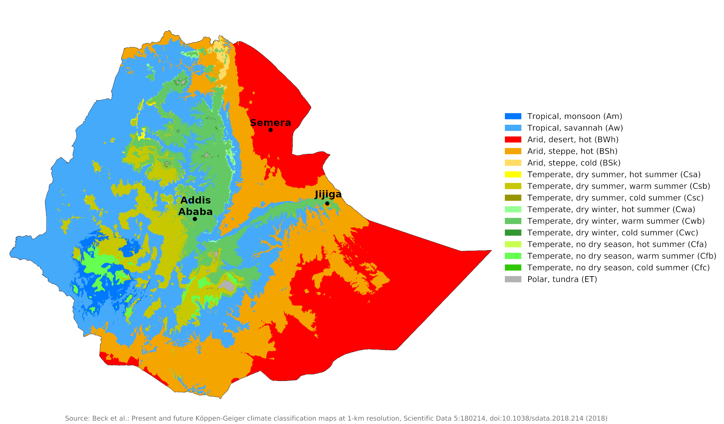 Climate map of Ethiopia
What is the climate of Ethiopia like?
Ethiopia is a mountainous country in East Africa, lying between 18° and 4°N. It is bordered by Sudan and South Sudan on the west, Kenya on the south, Somalia and Djibouti on the east, and Eritrea in the north. Large parts of the country are between 1,800 and 2,400 meters (6,000–8,000 feet) and the highest mountain reaches over 4,600 meters (15,000 feet). In the east of the country there are lowland regions.
Most of Ethiopia has a tropical climate, tempered by high altitude, with a pronounced rainy season during high sun. The eastern lowlands are much drier with a hot, semi-arid to desert climate. Ethiopia has three main climate zones: the dega or cool zone; the weina dega or temperate zone; and the kolla, or hot zone. Except for the hot lowlands, Ethiopia's climate is generally pleasant, although there is constant cloud and rain during the rainy season.
The Highlands
In the highlands above 2,400 meters (7,800 feet), daytime temperatures range from near freezing to 16°C (61°F), with March, April, and May being the warmest months. Nights are typically cold year-round, and it's not uncommon to see a light frost at sunrise. On the higher mountains, the climate is alpine. The atmosphere on the plateaus is extremely clear, making objects easily recognizable at great distances. Snow can occasionally fall on the highest peaks, but there are no permanent snowfields.
Above 1,800 meters (6,000 feet), daytime temperatures are quite similar to summertime in northern France or New England. The central plateau has a temperate climate with minimal seasonal temperature variation. The average minimum during the coldest season is 6°C (43°F), while the average maximum rarely exceeds 26°C (79°F). Addis Ababa is representative of the conditions in the central highlands, while Jijiga shows the climate in the highlands further east.
| Climate data for Addis Ababa (1981–2010) | |||||||||||||
|---|---|---|---|---|---|---|---|---|---|---|---|---|---|
| Month | Jan | Feb | Mar | Apr | May | Jun | Jul | Aug | Sep | Oct | Nov | Dec | Year |
| Average high °C (°F) | 24 (75) | 24 (75) | 25 (77) | 24 (75) | 25 (77) | 23 (73) | 21 (70) | 21 (70) | 22 (72) | 23 (73) | 23 (73) | 23 (73) | 23 (74) |
| Daily mean °C (°F) | 16.0 (60.8) | 16.8 (62.2) | 17.8 (64.0) | 17.8 (64.0) | 18.2 (64.8) | 16.8 (62.2) | 15.5 (59.9) | 15.6 (60.1) | 16.1 (61.0) | 16.1 (61.0) | 15.4 (59.7) | 15.2 (59.4) | 16.4 (61.5) |
| Average low °C (°F) | 8 (46) | 9 (48) | 10 (50) | 11 (52) | 11 (52) | 10 (50) | 10 (50) | 10 (50) | 10 (50) | 9 (48) | 7 (45) | 7 (45) | 9 (49) |
| Average precipitation mm (inches) | 13 (0.5) | 30 (1.2) | 58 (2.3) | 82 (3.2) | 84 (3.3) | 138 (5.4) | 280 (11.0) | 290 (11.4) | 149 (5.9) | 27 (1.1) | 7 (0.3) | 7 (0.3) | 1,165 (45.9) |
| Source: World Meteorological Organization | |||||||||||||
| Climate data for Jijiga | |||||||||||||
|---|---|---|---|---|---|---|---|---|---|---|---|---|---|
| Month | Jan | Feb | Mar | Apr | May | Jun | Jul | Aug | Sep | Oct | Nov | Dec | Year |
| Average high °C (°F) | 25.8 (78.4) | 26.7 (80.1) | 28.2 (82.8) | 26.7 (80.1) | 27.3 (81.1) | 26.7 (80.1) | 25.6 (78.1) | 25.9 (78.6) | 26.5 (79.7) | 26.7 (80.1) | 26.2 (79.2) | 25.6 (78.1) | 26.5 (79.7) |
| Daily mean °C (°F) | 16.4 (61.5) | 18.4 (65.1) | 20.3 (68.5) | 20.2 (68.4) | 20.9 (69.6) | 21.1 (70.0) | 20.5 (68.9) | 20.6 (69.1) | 20.7 (69.3) | 18.9 (66.0) | 17.4 (63.3) | 16.9 (62.4) | 19.4 (66.8) |
| Average low °C (°F) | 7.1 (44.8) | 10.2 (50.4) | 12.4 (54.3) | 13.7 (56.7) | 14.6 (58.3) | 15.5 (59.9) | 15.5 (59.9) | 15.3 (59.5) | 14.9 (58.8) | 11.2 (52.2) | 8.7 (47.7) | 8.2 (46.8) | 12.3 (54.1) |
| Average precipitation mm (inches) | 11 (0.4) | 25 (1.0) | 47 (1.9) | 105 (4.1) | 93 (3.7) | 101 (4.0) | 184 (7.2) | 127 (5.0) | 101 (4.0) | 41 (1.6) | 16 (0.6) | 6 (0.2) | 857 (33.7) |
| Source: Climate-Data.org | |||||||||||||
The Lowlands
Below 1,500 meters (4,900 feet) is the Kolla Zone with daily temperatures averaging 27°C (81°F) but rising to 40°C (104°F) increase during mid-year. This area encompasses the Denakil Depression, the Eritrean lowlands, the eastern Ogaden, the deep tropical valleys of the Blue Nile and Tekeze rivers, and the peripheral areas along the Sudanese and Kenyan borders.
In the northeastern lowlands, the Danakil Desert, and the southeastern lowlands, the Ogaden region, rainfall is low and temperatures high throughout the year. The weather and climate are similar to those in the neighboring countries of Somalia and Djibouti. The temperature ranges in the lowlands are much larger and the heat in the desert and near the Red Sea is extreme, with occasional highs approaching 50°C (122°F). Semera depicts conditions in the arid lowlands of the Northeast.
| Climate data for Semera | |||||||||||||
|---|---|---|---|---|---|---|---|---|---|---|---|---|---|
| Month | Jan | Feb | Mar | Apr | May | Jun | Jul | Aug | Sep | Oct | Nov | Dec | Year |
| Average high °C (°F) | 30.1 (86.2) | 30.3 (86.5) | 32.4 (90.3) | 34.2 (93.6) | 36.7 (98.1) | 39.2 (102.6) | 38.0 (100.4) | 36.4 (97.5) | 36.0 (96.8) | 34.3 (93.7) | 32.0 (89.6) | 30.5 (86.9) | 34.2 (93.5) |
| Daily mean °C (°F) | 24.2 (75.6) | 25.0 (77.0) | 26.6 (79.9) | 28.1 (82.6) | 30.1 (86.2) | 32.3 (90.1) | 31.0 (87.8) | 30.0 (86.0) | 30.2 (86.4) | 28.1 (82.6) | 25.9 (78.6) | 24.6 (76.3) | 28.0 (82.4) |
| Average low °C (°F) | 18.3 (64.9) | 19.8 (67.6) | 20.9 (69.6) | 22.1 (71.8) | 23.6 (74.5) | 25.5 (77.9) | 24.0 (75.2) | 23.6 (74.5) | 24.4 (75.9) | 21.9 (71.4) | 19.8 (67.6) | 18.7 (65.7) | 21.9 (71.4) |
| Average precipitation mm (inches) | 7 (0.3) | 8 (0.3) | 29 (1.1) | 20 (0.8) | 11 (0.4) | 5 (0.2) | 40 (1.6) | 52 (2.0) | 16 (0.6) | 6 (0.2) | 7 (0.3) | 2 (0.1) | 203 (7.9) |
| Source: Climate-Data.org | |||||||||||||
Rainfall
Ethiopia is influenced by the seasonal Atlantic monsoon trade winds that cross the African continent. The year can be divided into three seasons. The winter or cold season lasts from October to February and is followed by a dry hot period giving way to the rainy season around mid-June. The actual rainy season, caused by the southwest monsoon, lasts from June to mid-September and moves from north to south.
The country receives most of its rain, the main meher rains, from mid-June to mid-September, with the high plateau experiencing a second and light rainy season from December to February. Converging winds in April and May bring lighter rains known as balg. These rains are followed by a short period of hot dry weather, and toward the middle of June violent thunderstorms occur almost daily.
In the southwest, precipitation is more evenly distributed and also more abundant, reaching up to 2,000 millimeters (80 inches) per year. The relative humidity and rainfall decrease generally from south to north and also in the eastern lowlands. Up to 1,200 millimeters (48 inches) of rain falls annually in the highlands. The northern provinces receive less precipitation and Ogaden to the east receives only 100 millimeters (4 inches), and precipitation in the Great Rift Valley and Danakil Depression is negligible. The sparse rainfall in the lowlands is very unreliable and severe droughts can occur.
In most parts of Ethiopia, sunshine is greatly reduced during the rainy season, when there are an average of two to four hours a day in July and August, compared to eight to nine hours in the months of November to February. Thunderstorms are very common in the wetter parts of the country and occur almost daily during the rainy season; In many places there are over a hundred thunderstorms a year. The rainy season is of great importance not only for Ethiopia but also for the Nile Valley countries as the Nile River's water supply is highly dependent on rainfall.
References
- E. A. Pearce, Charles Gordon Smith, (1990) The Hutchinson World Weather Guide, John Murray Press. ISBN 1859863426
- Timothy L. Gall, (ed.), (2003), Worldmark Encyclopedia of the Nations, Eleventh Edition, Thomson Gale
- Federal Research Division, Library of Congress, (1993), Ethiopia: a country study. Claitor's Pub. Division. ISBN 0844407399
- Hugh Chisholm, (ed.), (1911), Encyclopædia Britannica, Eleventh edition, Cambridge University Press
The Climate of
Ethiopia
In summary:
Ethiopian climate varies according to the different topographical regions. The central plateau has a moderate climate with minimal seasonal temperature variation. The mean minimum during the coldest season is 6°C (43°F), while the mean maximum rarely exceeds 26°C (79°F). Temperature variations in the lowlands are much greater, and the heat in the desert and near the Red Sea is extreme, with occasional highs approaching 50°C (122°F).
Heavy rainfall occurs in most of the country during June, July, and August. The High Plateau also experiences a second, though much milder, rainy season between December and February. Average annual rainfall on the central plateau is roughly 1200 mm (48 in). The northern provinces receive less rainfall, and severe droughts can affect the country.