The Climate of
Somalia
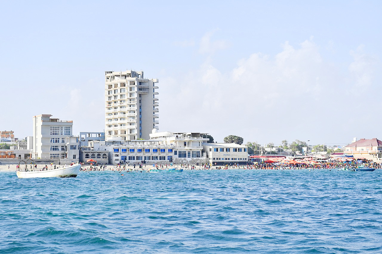 Lido Beach, Mogadishu
Climate Map
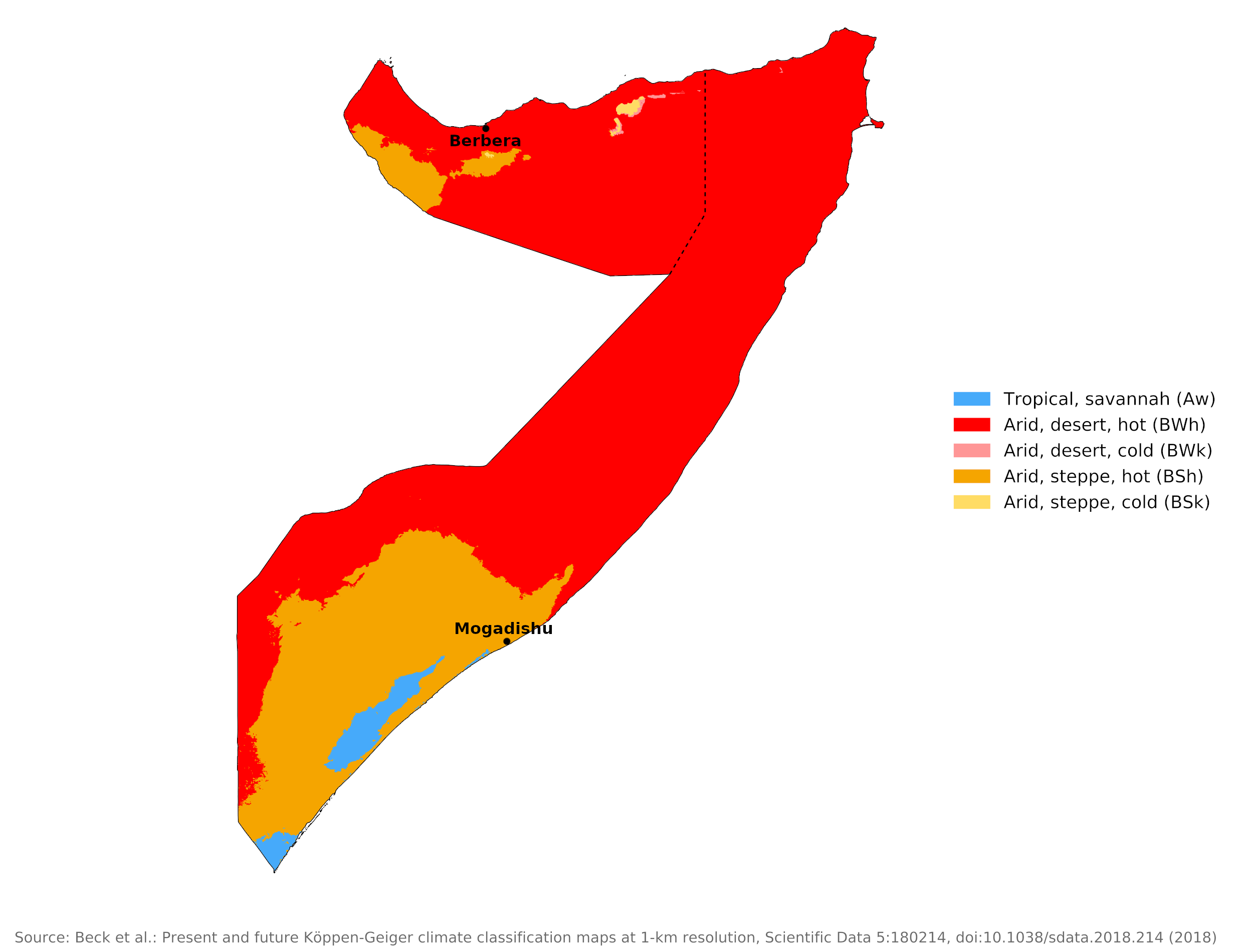 Climate map of Somalia
What is the climate of Somalia like?
Somalia occupies the northeastern corner of Africa, often called the Horn of Africa. It is bordered on the west by Ethiopia and on the south by Kenya. It extends from 2°S to 12°N and has a long coastline on the Indian Ocean and Gulf of Aden.
Somalia has an arid or semiarid climate. In normal years there are four seasons, two with rain and two essentially without rain. December through March, the time of the northeast monsoon winds, is a very dry season, with moderate temperatures in the north and hot temperatures in the south. April through June is a spring-like rainy season with hot temperatures; for a brief period lush vegetation covers most of the land, and the desert is turned into a flowering garden. July through September, the time of the southwest monsoon winds, is a dry and hot season. October and November is a humid, sporadically rainy season.
Temperatures along the east coast are prevented from rising too high by a cold offshore current which makes the sea surface temperature in this part of the Indian Ocean surprisingly low for tropical waters. This cold water may be one of the reasons for the very low rainfall in much of the country. The climate of Mogadishu shows that temperatures vary little from month to month. Relative humidity remains high.
| Climate data for Mogadishu | |||||||||||||
|---|---|---|---|---|---|---|---|---|---|---|---|---|---|
| Month | Jan | Feb | Mar | Apr | May | Jun | Jul | Aug | Sep | Oct | Nov | Dec | Year |
| Average high °C (°F) | 30.2 (86.4) | 30.2 (86.4) | 30.9 (87.6) | 32.2 (90.0) | 31.2 (88.2) | 29.6 (85.3) | 28.6 (83.5) | 28.6 (83.5) | 29.4 (84.9) | 30.2 (86.4) | 30.6 (87.1) | 30.8 (87.4) | 30.2 (86.4) |
| Daily mean °C (°F) | 26.6 (79.9) | 26.9 (80.4) | 28.0 (82.4) | 28.9 (84.0) | 28.2 (82.8) | 26.7 (80.1) | 25.4 (77.7) | 25.9 (78.6) | 26.5 (79.7) | 27.3 (81.1) | 27.5 (81.5) | 26.9 (80.4) | 27.1 (80.8) |
| Average low °C (°F) | 23.0 (73.4) | 23.4 (74.1) | 24.9 (76.8) | 25.6 (78.1) | 24.9 (76.8) | 23.7 (74.7) | 23.1 (73.6) | 23.0 (73.4) | 23.4 (74.1) | 24.3 (75.7) | 24.2 (75.6) | 23.5 (74.3) | 23.9 (75.0) |
| Average precipitation mm (inches) | 0 (0) | 0 (0) | 8 (0.3) | 61 (2.4) | 61 (2.4) | 82 (3.2) | 64 (2.5) | 44 (1.7) | 25 (1.0) | 32 (1.3) | 43 (1.7) | 9 (0.4) | 428 (16.9) |
| Source: Deutscher Wetterdienst | |||||||||||||
By contrast, along the north coast very high temperatures are experienced between April and September as the offshore waters here are very warm. This part of Somalia and the adjoining areas around the Gulf of Aden have a most uncomfortable climate at this time, being very hot and also humid on the coast. Inland it is even hotter but with lower humidity. Some places here have the highest mean annual temperatures in the world and there is a serious risk of heat exhaustion during the hottest period.
For a country so near the equator, it has a surprisingly dry climate. Much of the country is desert or desert scrub. Almost no part has an annual rainfall exceeding 625 millimeters (25 inches) and much of it receives less than 250 millimeters (10 inches). A large area encompassing the northeast and much of northern Somalia (Somaliland) receives as little as 50 to 150 millimeters (2–6 inches). In the north some rain occurs during the season of low sun when temperatures are a little lower, but this area is very dry for the rest of the year (see the climate of Berbera in Somaliland). Certain higher areas in the north, however, record more than 500 millimeters (20 inches) a year, as do some coastal sites.
Elsewhere the rainy season is the period of high sun from April to September as in most of Ethiopia. Southwestern Somalia receives 330 to 500 millimeters (13–20 inches). Generally, rainfall takes the form of showers or localized torrential rains. The rains are very variable from year to year and drought is a constant problem.
| Climate data for Berbera | |||||||||||||
|---|---|---|---|---|---|---|---|---|---|---|---|---|---|
| Month | Jan | Feb | Mar | Apr | May | Jun | Jul | Aug | Sep | Oct | Nov | Dec | Year |
| Average high °C (°F) | 27.9 (82.2) | 29.2 (84.6) | 30.7 (87.3) | 31.0 (87.8) | 35.7 (96.3) | 42.8 (109.0) | 42.9 (109.2) | 41.9 (107.4) | 39.7 (103.5) | 33.1 (91.6) | 30.0 (86.0) | 28.6 (83.5) | 34.5 (94.1) |
| Daily mean °C (°F) | 25.0 (77.0) | 25.0 (77.0) | 26.1 (79.0) | 28.3 (82.9) | 31.1 (88.0) | 33.5 (92.3) | 36.1 (97.0) | 35.6 (96.1) | 33.3 (91.9) | 28.8 (83.8) | 26.7 (80.1) | 26.7 (80.1) | 30.0 (86.0) |
| Average low °C (°F) | 21.3 (70.3) | 21.6 (70.9) | 23.3 (73.9) | 25.2 (77.4) | 27.7 (81.9) | 31.0 (87.8) | 31.8 (89.2) | 31.1 (88.0) | 29.3 (84.7) | 24.0 (75.2) | 22.2 (72.0) | 21.6 (70.9) | 25.8 (78.4) |
| Average precipitation mm (inches) | 8 (0.3) | 2 (0.1) | 5 (0.2) | 12 (0.5) | 8 (0.3) | 1 (0.0) | 1 (0.0) | 2 (0.1) | 1 (0.0) | 2 (0.1) | 5 (0.2) | 5 (0.2) | 52 (2.0) |
| Source: Arab Meteorology Book | |||||||||||||
Sunshine amounts are high in most of the country, averaging eight to ten hours a day around the year. They are lowest on the east coast during the rainy season, when there is more cloud and some coastal fog as warm air passes over the cold sea surface.
References
- E. A. Pearce, Charles Gordon Smith, (1990) The Hutchinson World Weather Guide, John Murray Press. ISBN 1859863426
- Timothy L. Gall, (ed.), (2003), Worldmark Encyclopedia of the Nations, Eleventh Edition, Thomson Gale
- Federal Research Division, Library of Congress, (1993), Somalia: a country study. Claitor's Pub. Division. ISBN 0844407755
- Hugh Chisholm, (ed.), (1911), Encyclopædia Britannica, Eleventh edition, Cambridge University Press
The Climate of
Somalia
In summary:
Somalia has an arid or semiarid climate, and there is little seasonal change in temperature. In the low areas, the mean temperature ranges from about 24°C to 31°C (75° to 88°F). The plateau region is cooler, the southwest warmer.
The periodic winds, the southwest monsoon (June–September), and the northeast monsoon (December–March) influence temperature and rainfall. Rain falls in two seasons of the year: heavy rains from March to May, and light rains from September to December. Average annual rainfall is generally below 500 mm (20 in). Droughts are not infrequent.