The Climate of
Kenya
.jpg) A Lioness rests in the Brush in Nairobi National Park
A Lioness rests in the Brush in Nairobi National Park
.jpg&oldid=610937922)
Climate Map
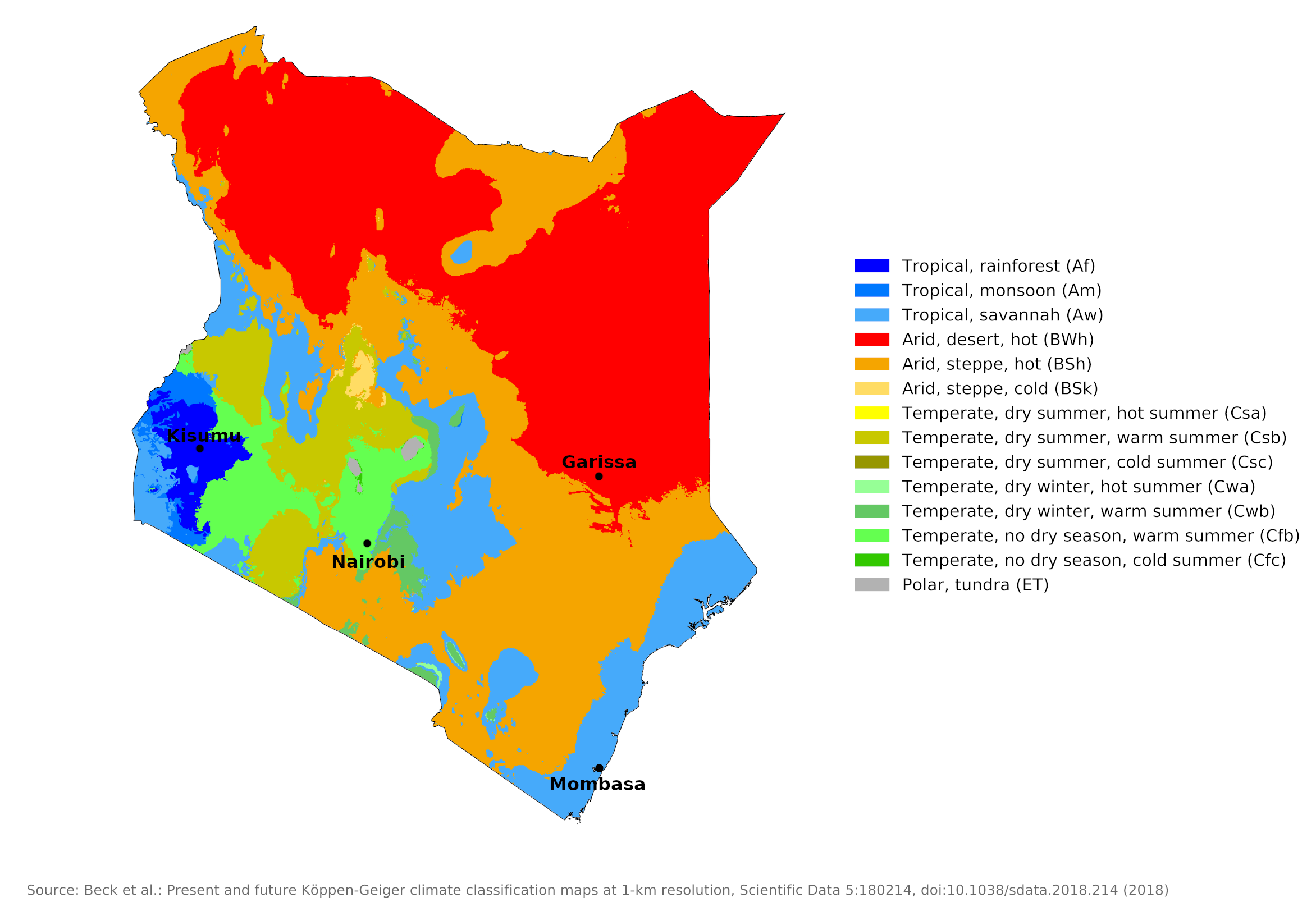 Climate map of Kenya
What is the climate of Kenya like?
Kenya is a country about the size of France and is located in East Africa between 5°N and 5°S. It has a very varied relief, with a low coastal plain on the shores of the Indian Ocean, extensive inland plateaus ranging from 900 to 1,500 meters (3,000 to 5,000 feet), and several mountain ranges and isolated peaks such as Mount Kenya rising to 5,200 meters (17,000 feet) and has a permanent snow cap. It is bordered on the north by Ethiopia and Somalia, on the south by Tanzania, and on the west by Uganda and the shores of Lake Victoria.
Due to the decrease in temperature with altitude, temperatures in much of Kenya are subtropical or temperate, similar to those in California, and summers are more likely in France or southern Britain than elsewhere in equatorial Africa. Only the coastal lowlands experience the consistently high temperatures and humidity associated with equatorial latitudes. Again, they're less oppressive than expected due to the regular sea breezes and longer hours of sunshine. It is not surprising that with such a favorable climate—sunny, only moderately wet and not too hot—and a wide variety of landscapes, wildlife, game parks and good transport links, Kenya attracts many tourists.
Although Kenya straddles the equator, annual rainfall is surprisingly low across most of the country and varies quite a bit from year to year. The intertropical cloud and rain belt sweeps over Kenya fairly quickly in April and October; The prevailing seasonal winds, the north and south monsoons, as they are called in East Africa, have a course parallel to the coast and have already passed over large areas, before reaching Kenya. Monthly rainfall is often erratic, and annual variations are striking and can be serious, especially in drier areas. Droughts sometimes affect all of Kenya, but especially its drier areas.
The main air masses are the northeast and southeast trade winds, which vary in intensity and direction. Normally, the northeast trade winds blowing in from the Arabian Peninsula (and the Sahara to the west) bring a dry season in late December that lasts until around March. In March, south-easterly trade winds sweeping across the Indian Ocean begin to leave rain across Kenya, and April sees rainfall across the country. A second dry period follows until July—except in the western parts of the country. Dry conditions then prevail until September or October, when a re-establishment of the low-pressure belt over Africa and converging trade winds bring what are known in Kenya as small rains. These continue into December when the seasonal cycle begins again.
The diversity of relief and elevation in Kenya produces a significant number of distinctive local climates. The country can be roughly divided into four climatic regions, each with distinct characteristics of the equatorial climate. Most regions of the country have two rainy seasons, the long rains falling between April and June and the short rains between October and December. Average annual rainfall varies from 130 millimeters (5 inches) per year in the driest regions of the northern plains to 1,900 millimeters (75 inches) near Lake Victoria. There is a small difference in temperature from month to month throughout the year. The most important climatic regions are:
The Coastal Region
Including part of Coast province (including the cities of Mombasa, Lamu).
The Coastal Region experiences both high temperatures and high humidity. The hottest months are January through March; at Mombasa the mean monthly temperature is about 28°C (82°F) during this time. Beginning in June and extending through August, a cooler period sets in when afternoon temperatures may average about 28°C (82°F) and night temperatures may drop to below 21°C (70°F). Little variation occurs, however, in the humidity, which throughout the year is above 90 percent early in the morning and usually between 60 and 70 percent in mid-afternoon.
Mean annual rainfall is over 1,000 millimeters (40 inches) except in the north, where it tends to be less. The wettest season is April and May when the intertropical rain belt moves north. The second rainy season in October and November, the "small rains", is less prominent. Some rain, often in the form of overnight or early morning showers, occurs in all months. Temperatures remain fairly high year-round, as does humidity; but the weather is less oppressive than might be supposed from the regular and strong onshore winds during the day and the greater number of hours of sunshine, averaging seven to eight a day in all months. However, the weather can feel muggy, especially at night. Mombasa is representative of this region.
| Climate data for Mombasa (1961–1990) | |||||||||||||
|---|---|---|---|---|---|---|---|---|---|---|---|---|---|
| Month | Jan | Feb | Mar | Apr | May | Jun | Jul | Aug | Sep | Oct | Nov | Dec | Year |
| Average high °C (°F) | 33.2 (91.8) | 33.7 (92.7) | 33.7 (92.7) | 32.5 (90.5) | 30.9 (87.6) | 29.4 (84.9) | 28.7 (83.7) | 28.8 (83.8) | 29.7 (85.5) | 30.5 (86.9) | 31.6 (88.9) | 32.8 (91.0) | 31.3 (88.3) |
| Daily mean °C (°F) | 27.6 (81.7) | 28.1 (82.6) | 28.3 (82.9) | 27.6 (81.7) | 26.2 (79.2) | 24.8 (76.6) | 24.0 (75.2) | 24.0 (75.2) | 24.7 (76.5) | 25.7 (78.3) | 26.9 (80.4) | 27.4 (81.3) | 26.3 (79.3) |
| Average low °C (°F) | 22.0 (71.6) | 22.5 (72.5) | 22.9 (73.2) | 22.7 (72.9) | 21.6 (70.9) | 20.1 (68.2) | 19.3 (66.7) | 19.3 (66.7) | 19.7 (67.5) | 20.9 (69.6) | 22.1 (71.8) | 22.0 (71.6) | 21.3 (70.3) |
| Average precipitation mm (inches) | 33.9 (1.33) | 14.0 (0.55) | 55.6 (2.19) | 154.3 (6.07) | 235.5 (9.27) | 88.3 (3.48) | 71.8 (2.83) | 68.2 (2.69) | 67.2 (2.65) | 103.4 (4.07) | 104.7 (4.12) | 75.8 (2.98) | 1,072.7 (42.23) |
| Source: NOAA | |||||||||||||
The Northern Frontier Districts and the Lower Inland Plateau
Including Northeastern province (including the cities of Garissa, Wajir) and the northern parts of Eastern (including the city of Marsabit) and Rift Valley provinces.
The low plateaus of eastern Kenya and the northern plains register mean annual maximums between 30°C and 34°C (86–93°F) and minimums from 18°C to over 22°C (64–72°F). One area to the west of Lake Rudolf and another along the Somalia border have mean maximum temperatures above 34°C (93°F). The Rift Valley experiences temperatures similar to those in eastern Kenya. The humidity in the semiarid to arid areas usually is between 60 and 70 percent in early morning. It decreases by midafternoon to roughly 40 to 45 percent and in some places to as low as 30 percent.
In large parts of this region, there is very little annual precipitation for an equatorial region. Rainfall is generally under 500 millimeters (20 inches) and often under 250 millimeters (10 inches) in the far north. In the lower districts, temperatures are high all year round, there is plenty of sunshine and the region is a typical hot desert like the adjacent southern parts of Somalia and Ethiopia. Humidity is low and apart from the occasional excessive heat, it's more comfortable than the coast.
| Climate data for Garissa (1961-1990) | |||||||||||||
|---|---|---|---|---|---|---|---|---|---|---|---|---|---|
| Month | Jan | Feb | Mar | Apr | May | Jun | Jul | Aug | Sep | Oct | Nov | Dec | Year |
| Average high °C (°F) | 36.7 (98.1) | 37.8 (100.0) | 38.3 (100.9) | 37.0 (98.6) | 35.8 (96.4) | 34.1 (93.4) | 33.6 (92.5) | 33.8 (92.8) | 35.1 (95.2) | 36.3 (97.3) | 36.2 (97.2) | 35.4 (95.7) | 35.8 (96.5) |
| Daily mean °C (°F) | 29.7 (85.5) | 30.6 (87.1) | 31.4 (88.5) | 30.7 (87.3) | 29.6 (85.3) | 27.9 (82.2) | 27.4 (81.3) | 27.6 (81.7) | 28.4 (83.1) | 29.7 (85.5) | 29.9 (85.8) | 29.2 (84.6) | 29.3 (84.8) |
| Average low °C (°F) | 22.6 (72.7) | 23.3 (73.9) | 24.4 (75.9) | 24.5 (76.1) | 23.3 (73.9) | 21.8 (71.2) | 21.2 (70.2) | 21.3 (70.3) | 21.7 (71.1) | 23.1 (73.6) | 23.6 (74.5) | 23.0 (73.4) | 22.8 (73.1) |
| Average precipitation mm (inches) | 11.9 (0.47) | 5.5 (0.22) | 48.6 (1.91) | 89.7 (3.53) | 15.5 (0.61) | 5.2 (0.20) | 3.4 (0.13) | 6.6 (0.26) | 8.4 (0.33) | 30.0 (1.18) | 96.9 (3.81) | 51.9 (2.04) | 373.6 (14.71) |
| Source: NOAA | |||||||||||||
The Kenya Highlands
Most of this region is between 1,200 and 2,100 meters (4,000–7,000 feet) and occupies the center and west of the country on either side of the eastern rift valley and extends to the Ugandan border. It is the most densely populated part of the country and contains the most productive agricultural land.
The Kenya Highlands offer a cool, bracing climate, much of the highlands having a mean annual maximum temperature between 22°C and 26°C (72–79°F) and a minimum between 10°C and 14°C (50–57°F). Nairobi, at 1,800 meters (5,900 feet), has a mean annual temperature of about 18°C (64°F). The humidity in the highlands is about 90 percent in early morning. By mid-afternoon it drops substantially to about 40 percent in the dry season and to between 50 and 60 percent in the rainy season.
There is a double rainy season, but rainfall is moderate, exceeding 1,250 millimeters (50 inches) per year only at the higher elevations. Across most of the region, the sunniest time of the year is December to March. The cloudiest time is from June to September, when there is a lot of drizzle but little heavy rain. This time is often referred to as 'winter' in the Kenyan highlands and the evenings can feel chilly compared to the sunnier months. Nairobi is representative of much of the region.
| Climate data for Nairobi | |||||||||||||
|---|---|---|---|---|---|---|---|---|---|---|---|---|---|
| Month | Jan | Feb | Mar | Apr | May | Jun | Jul | Aug | Sep | Oct | Nov | Dec | Year |
| Average high °C (°F) | 24.5 (76.1) | 25.6 (78.1) | 25.6 (78.1) | 24.1 (75.4) | 22.6 (72.7) | 21.5 (70.7) | 20.6 (69.1) | 21.4 (70.5) | 23.7 (74.7) | 24.7 (76.5) | 23.1 (73.6) | 23.4 (74.1) | 23.4 (74.1) |
| Daily mean °C (°F) | 18.0 (64.4) | 18.6 (65.5) | 19.4 (66.9) | 19.1 (66.4) | 17.9 (64.2) | 16.3 (61.3) | 15.4 (59.7) | 15.8 (60.4) | 17.1 (62.8) | 18.6 (65.5) | 18.1 (64.6) | 18.0 (64.4) | 17.7 (63.9) |
| Average low °C (°F) | 11.5 (52.7) | 11.6 (52.9) | 13.1 (55.6) | 14.0 (57.2) | 13.2 (55.8) | 11.0 (51.8) | 10.1 (50.2) | 10.2 (50.4) | 10.5 (50.9) | 12.5 (54.5) | 13.1 (55.6) | 12.6 (54.7) | 12.0 (53.6) |
| Average precipitation mm (inches) | 64.1 (2.52) | 56.5 (2.22) | 92.8 (3.65) | 219.4 (8.64) | 176.6 (6.95) | 35.0 (1.38) | 17.5 (0.69) | 23.5 (0.93) | 28.3 (1.11) | 55.3 (2.18) | 154.2 (6.07) | 101.0 (3.98) | 1,024.2 (40.32) |
| Source: World Meteorological Organization | |||||||||||||
Lake Victoria
The region around Lake Victoria has its own climate, since this lake is effectively an inland sea. Kisumu on the shores of Lake Victoria, shows that there is consistent rain in every, or almost every, month of the year and no real dry season. This is a result of greater moisture being picked up by the winds crossing the lake and a tendency for thunderstorms to break out during the night. There are, nonetheless, periods of higher rainfall around April and December. To the north of this area, regional conditions also result in a wet season that lasts usually from March to September or October and a drier or dry period during the intervening months.
| Climate data for Kisumu (1938–1990) | |||||||||||||
|---|---|---|---|---|---|---|---|---|---|---|---|---|---|
| Month | Jan | Feb | Mar | Apr | May | Jun | Jul | Aug | Sep | Oct | Nov | Dec | Year |
| Average high °C (°F) | 30.6 (87.1) | 30.8 (87.4) | 30.4 (86.7) | 28.8 (83.8) | 28.2 (82.8) | 27.9 (82.2) | 27.7 (81.9) | 28.2 (82.8) | 29.4 (84.9) | 30.5 (86.9) | 30.1 (86.2) | 29.9 (85.8) | 29.4 (84.9) |
| Daily mean °C (°F) | 27.2 (81.0) | 27.5 (81.5) | 27.3 (81.1) | 26.1 (79.0) | 25.5 (77.9) | 25.1 (77.2) | 24.8 (76.6) | 25.2 (77.4) | 26.1 (79.0) | 27.2 (81.0) | 26.9 (80.4) | 26.7 (80.1) | 26.3 (79.3) |
| Average low °C (°F) | 23.8 (74.8) | 24.1 (75.4) | 24.1 (75.4) | 23.4 (74.1) | 22.8 (73.0) | 22.2 (72.0) | 21.9 (71.4) | 22.2 (72.0) | 22.8 (73.0) | 23.8 (74.8) | 23.7 (74.7) | 23.5 (74.3) | 23.2 (73.8) |
| Average precipitation mm (inches) | 79 (3.1) | 84 (3.3) | 169 (6.7) | 213 (8.4) | 167 (6.6) | 85 (3.3) | 85 (3.3) | 81 (3.2) | 90 (3.5) | 95 (3.7) | 139 (5.5) | 101 (4.0) | 1,388 (54.6) |
| Source: World Meteorological Organization | |||||||||||||
The Higher Mountain Regions
These are the small regions above 2,500 meters (8,000 feet) and isolated higher mountains like Mount Elgon and Mount Kenya. Here, temperatures drop so low that frost occurs, and snowfall can occur at higher elevations. Mount Kenya has permanent snowfields.
References
- E. A. Pearce, Charles Gordon Smith, (1990) The Hutchinson World Weather Guide, John Murray Press. ISBN 1859863426
- Timothy L. Gall, (ed.), (2003), Worldmark Encyclopedia of the Nations, Eleventh Edition, Thomson Gale
- Federal Research Division, Library of Congress, (1983), Kenya: a country study. Claitor's Pub. Division.
- Hugh Chisholm, (ed.), (1911), Encyclopædia Britannica, Eleventh edition, Cambridge University Press
The Climate of
Kenya
In summary:
The climate of Kenya is as varied as its topography. Weather conditions range from the tropical humidity of the coast and the dry heat of the northern plains to the coolness of the plateau and mountains. The coastal temperature averages 27°C (81°F), but the temperature decreases about 2°C (3°F) with each increase of 300 meters (1,000 feet) in altitude. The annual average temperature in Nairobi is 18°C (64°F).
Seasons are determined by rainfall rather than by changes of temperature. Most regions of the country have two rainy seasons: the long rainy season between April and June and the short one between October and December.