The Climate of
Syria
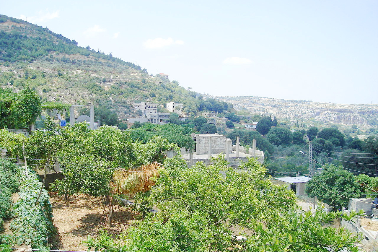 Hills of Latakia Governorate
Climate Map
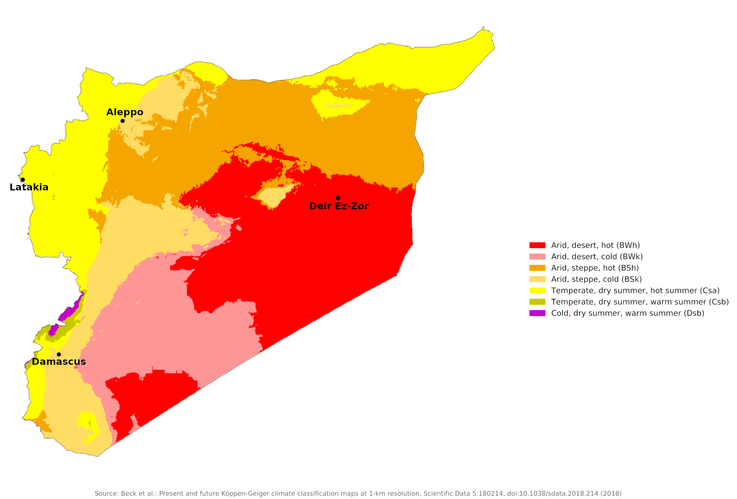 Climate map of Syria
What is the climate of Syria like?
Syria is located in the Middle East with a coastline on the Mediterranean Sea. It is bounded on the north by Turkey, on the east by Iraq, on the south by Jordan, on the southwest by Israel and Lebanon. The terrain of Syria consists of a fairly narrow series of mountain ranges in the west giving way to a broad plateau sloping gently to the east and bisected by the Euphrates Valley.
Syria has a transitional climate between the Mediterranean Sea and the Arabian Desert. It shows a great contrast between the milder, wetter Mediterranean conditions on the coast and the desert conditions inland.
The Desert
About sixty percent of Syria, that which lies east of Aleppo and Damascus, has a desert or semi-desert climate with an annual rainfall of less than 200 millimeters (8 inches). This is the hottest region in summer and often quite cold in winter with occasional snowfall and frequent frosts (see Deir ez-Zor climate). The scanty amounts of rain, moreover, are highly variable from year to year, causing periodic droughts. Rainfall, although rare, can be quite heavy and very localized, causing some spectacular desert flooding. Sandstorms, common during February and May, damage vegetation and prevent grazing.
| Climate data for Deir Ez-Zor (1961–1990) | |||||||||||||
|---|---|---|---|---|---|---|---|---|---|---|---|---|---|
| Month | Jan | Feb | Mar | Apr | May | Jun | Jul | Aug | Sep | Oct | Nov | Dec | Year |
| Average high °C (°F) | 12.2 (54.0) | 15.1 (59.2) | 19.5 (67.1) | 25.4 (77.7) | 31.7 (89.1) | 36.9 (98.4) | 39.9 (103.8) | 39.3 (102.7) | 35.3 (95.5) | 28.8 (83.8) | 20.7 (69.3) | 14.0 (57.2) | 26.6 (79.9) |
| Daily mean °C (°F) | 6.7 (44.1) | 9.1 (48.4) | 13.1 (55.6) | 18.7 (65.7) | 24.5 (76.1) | 29.6 (85.3) | 32.6 (90.7) | 31.7 (89.1) | 26.9 (80.4) | 20.9 (69.6) | 13.3 (55.9) | 8.1 (46.6) | 19.6 (67.3) |
| Average low °C (°F) | 2.5 (36.5) | 3.7 (38.7) | 7.0 (44.6) | 12.0 (53.6) | 17.1 (62.8) | 21.9 (71.4) | 25.1 (77.2) | 24.5 (76.1) | 19.4 (66.9) | 13.7 (56.7) | 7.2 (45.0) | 3.2 (37.8) | 13.1 (55.6) |
| Average precipitation mm (inches) | 28.1 (1.11) | 24.1 (0.95) | 27.8 (1.09) | 22.2 (0.87) | 8.6 (0.34) | 0.3 (0.01) | 0.0 (0.0) | 0.0 (0.0) | 0.2 (0.01) | 8.0 (0.31) | 12.4 (0.49) | 24.1 (0.95) | 155.8 (6.13) |
| Source: Deutscher Wetterdienst | |||||||||||||
The Fertile Crescent
A strip of steppe extends to the north and west of this desert region. This is a semi-arid steppe zone extending across threequarters of the country and bordered on the west by the Anti-Lebanon Mountains. Often called the Fertile Crescent, this belt encompasses the great city of Aleppo. Most of the rain, carried by winds from the Mediterranean, falls between November and May. Annual rainfall here ranges from 200 millimeters (8 inches) to 1,000 millimeters (40 inches). Cloudless skies and high daytime temperatures prevail during the summer, but frosts are common from November to March.
| Climate data for Aleppo (1961–1990) | |||||||||||||
|---|---|---|---|---|---|---|---|---|---|---|---|---|---|
| Month | Jan | Feb | Mar | Apr | May | Jun | Jul | Aug | Sep | Oct | Nov | Dec | Year |
| Average high °C (°F) | 10.0 (50.0) | 12.5 (54.5) | 16.5 (61.7) | 22.2 (72.0) | 28.8 (83.8) | 33.5 (92.3) | 36.0 (96.8) | 35.9 (96.6) | 33.1 (91.6) | 26.6 (79.9) | 18.5 (65.3) | 12.1 (53.8) | 23.8 (74.8) |
| Daily mean °C (°F) | 5.6 (42.1) | 7.4 (45.3) | 11.0 (51.8) | 15.8 (60.4) | 21.1 (70.0) | 25.8 (78.4) | 28.3 (82.9) | 28.1 (82.6) | 25.2 (77.4) | 19.4 (66.9) | 12.3 (54.1) | 7.3 (45.1) | 17.3 (63.1) |
| Average low °C (°F) | 1.7 (35.1) | 2.9 (37.2) | 5.3 (41.5) | 9.3 (48.7) | 13.6 (56.5) | 18.0 (64.4) | 20.9 (69.6) | 20.8 (69.4) | 17.6 (63.7) | 12.5 (54.5) | 6.6 (43.9) | 3.4 (38.1) | 11.1 (52.0) |
| Average precipitation mm (inches) | 60.0 (2.36) | 51.0 (2.01) | 45.2 (1.78) | 33.5 (1.32) | 19.0 (0.75) | 2.3 (0.09) | 0.1 (0.00) | 0.0 (0.0) | 1.3 (0.05) | 22.5 (0.89) | 36.1 (1.42) | 58.4 (2.30) | 329.4 (12.97) |
| Source: Deutscher Wetterdienst | |||||||||||||
The Mountains and the Coast
Between this inland steppe region and the Mediterranean Sea are a number of mountain ranges and hills where rainfall is much greater, and snow can lie on the highest peaks from late December to April. There are a number of small mountain resorts popular for respite from the summer heat of the interior and larger cities.
The coastal region of Syria has a Mediterranean climate with hot, humid summers. Winters are very mild with clouds and heavy rain alternating with fine, sunny weather. It rains copiously on the coast, averaging about 800 to 900 millimeters (31 to 35 inches). The wettest months are December and January, while summers are mostly rain-free. Latakia is the most important port city in Syria.
| Climate data for Latakia (1961–1990) | |||||||||||||
|---|---|---|---|---|---|---|---|---|---|---|---|---|---|
| Month | Jan | Feb | Mar | Apr | May | Jun | Jul | Aug | Sep | Oct | Nov | Dec | Year |
| Average high °C (°F) | 15.4 (59.7) | 16.4 (61.5) | 18.3 (64.9) | 21.5 (70.7) | 24.1 (75.4) | 25.8 (78.4) | 28.8 (83.8) | 29.6 (85.3) | 29.0 (84.2) | 26.3 (79.3) | 21.9 (71.4) | 17.6 (63.7) | 22.9 (73.2) |
| Daily mean °C (°F) | 11.6 (52.9) | 12.6 (54.7) | 14.8 (58.6) | 17.8 (64.0) | 20.7 (69.3) | 23.8 (74.8) | 26.3 (79.3) | 27.0 (80.6) | 25.6 (78.1) | 22.3 (72.1) | 17.5 (63.5) | 13.3 (55.9) | 19.4 (66.9) |
| Average low °C (°F) | 8.4 (47.1) | 9.1 (48.4) | 11.0 (51.8) | 14.0 (57.2) | 17.0 (62.6) | 20.7 (69.3) | 23.7 (74.7) | 24.3 (75.7) | 21.9 (71.4) | 18.2 (64.8) | 13.8 (56.8) | 10.1 (50.2) | 16.0 (60.8) |
| Average precipitation mm (inches) | 185.2 (7.29) | 97.0 (3.82) | 91.5 (3.60) | 48.5 (1.91) | 22.4 (0.88) | 5.2 (0.20) | 1.3 (0.05) | 2.3 (0.09) | 8.0 (0.31) | 69.3 (2.73) | 95.5 (3.76) | 185.2 (7.29) | 811.4 (31.94) |
| Source: NOAA | |||||||||||||
The Southwest
To the south, however, the Anti-Lebanon mountains stop the rains from the Mediterranean Sea, and the area, including the capital Damascus, becomes part of the semi-arid zone of the steppe, averaging less than 200 millimeters (8 inches) precipitation per year and average temperatures from 7°C (44°F) in January to 28°C (82°F) in July and August. However, the area surrounding the capital is green and cultivable due to the irrigation from the Barada River and because of aqueducts built since Roman times.
| Climate data for Damascus (1991–2020) | |||||||||||||
|---|---|---|---|---|---|---|---|---|---|---|---|---|---|
| Month | Jan | Feb | Mar | Apr | May | Jun | Jul | Aug | Sep | Oct | Nov | Dec | Year |
| Average high °C (°F) | 12.9 (55.2) | 15.1 (59.2) | 20.0 (68.0) | 25.1 (77.2) | 30.7 (87.3) | 35.1 (95.2) | 37.6 (99.7) | 37.4 (99.3) | 34.3 (93.7) | 28.8 (83.8) | 20.5 (68.9) | 14.7 (58.5) | 26.0 (78.8) |
| Daily mean °C (°F) | 6.5 (43.7) | 8.2 (46.8) | 12.1 (53.8) | 16.6 (61.9) | 21.7 (71.1) | 25.6 (78.1) | 27.8 (82.0) | 27.6 (81.7) | 24.7 (76.5) | 19.8 (67.6) | 12.5 (54.5) | 7.8 (46.0) | 17.6 (63.6) |
| Average low °C (°F) | 1.2 (34.2) | 2.3 (36.1) | 5.0 (41.0) | 8.3 (46.9) | 12.4 (54.3) | 16.0 (60.8) | 18.8 (65.8) | 18.7 (65.7) | 15.4 (59.7) | 11.4 (52.5) | 5.6 (42.1) | 2.3 (36.1) | 9.8 (49.6) |
| Average precipitation mm (inches) | 25 (1.0) | 26 (1.0) | 20 (0.8) | 7 (0.3) | 4 (0.2) | 1 (0.0) | 0 (0) | 0 (0) | 0 (0) | 6 (0.2) | 21 (0.8) | 21 (0.8) | 131 (5.1) |
| Source: www.pogodaiklimat.ru | |||||||||||||
References
- E. A. Pearce, Charles Gordon Smith, (1990) The Hutchinson World Weather Guide, John Murray Press. ISBN 1859863426
- Timothy L. Gall, (ed.), (2003), Worldmark Encyclopedia of the Nations, Eleventh Edition, Thomson Gale
- Federal Research Division, Library of Congress, (1988), Syria: a country study. Claitor's Pub. Division.
- Hugh Chisholm, (ed.), (1911), Encyclopædia Britannica, Eleventh edition, Cambridge University Press
The Climate of
Syria
In summary:
The climate of Syria varies from a Mediterranean climate in the west to extremely arid desert conditions in the east. The coastal regions have hot summers and mild winters; in the mountains, summer heat is moderated by altitude and the winters are cold.
Rainfall averages about 800 mm (31 in) on the coast, increasing to 1250 mm (50 in) in some mountain areas. But it is less than 250 mm (10 in) in the eastern two-thirds of the country. In dry years, rainfall may be reduced by half.