The Climate of
Mozambique
.jpg) Independence Square in Maputo
Independence Square in Maputo
.jpg&oldid=452024329)
Climate Map
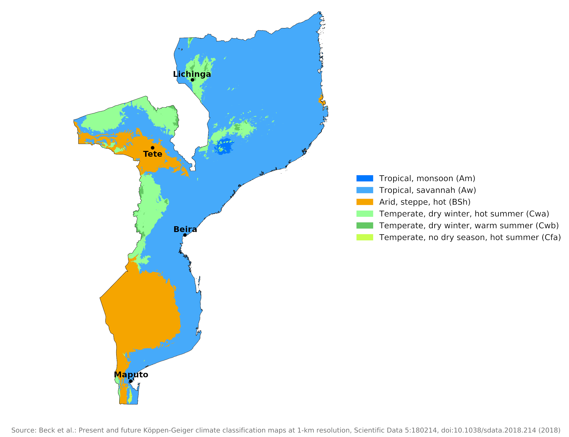 Climate map of Mozambique
What is the climate of Mozambique like?
Mozambique is located on the east coast of southern Africa between latitudes 11° and 27° S and has a coastline of over 1,900 km (1,200 mi). The country is three times the size of the United Kingdom. It is bordered on the west by Malawi, Zimbabwe, and South Africa.
Although it extends outside the tropics, the extreme south of the country has a typically tropical climate. The extensive coastal lowlands are warm to hot most of the year, while the interior plateau and hills along the border with Malawi and Zimbabwe are mild to warm even in the cooler dry season from April to September.
The warm Mozambique Current flows south along the coast and raises temperatures and humidity along the coast. Rainfall is particularly heavy along the central coast; Beira gets 1,600 millimeters (64 inches) of rain annually. North and south of this region the annual rainfall decreases to around 800 millimeters (32 inches).
Two main seasons, one wet and one dry, divide the climate year. The whole country experiences a single rainy season at the time of high sun, when the intertropical cloud and rain belt is furthest south. About four-fifths or more of the total annual rainfall occurs during the wet season lasting from November to March. Fluctuations in rainfall often result in droughts.
Temperatures are highest during the wet season, with monthly average temperatures between 27°C and 29°C (81–84°F). The dry season lasts from April to October with temperatures averaging 18 to 20°C (64–68°F) in June and July. Inland there are number of widely scattered highland areas over 1,000 meters (3,000 feet) with cooler temperatures and ample rainfall.
The wettest regions are the highlands bordering Malawi and Zimbabwe and the central-southern near Beira, which are more exposed to the south-east trade winds throughout the year. Here, annual rainfall ranges from 1,000 to 1,500 millimeters (40 to 60 inches). The driest areas are the inland lowlands, particularly the Zambezi Valley, at between 500 and 750 millimeters (20 to 30 inches). In some places, annual rainfall is as little as 375 millimeters (15 inches).
In the south, most rain falls between December and March, but further north this period is extended by a few weeks. The coast of northern Mozambique is occasionally hit by tropical cyclones in the Indian Ocean. These move south between Madagascar and the mainland, but most pass east of Madagascar and hardly affect Mozambique. These cyclones bring heavy rain and strong winds that can cause major damage. One reason for the comparatively low rainfall in parts of the coastal lowlands is the shelter afforded by the large mountainous island of Madagascar, which is fully exposed to the humid south-east trade winds. The east side of Madagascar is particularly wet compared to Mozambique.
Temperatures along the coast and in some lowland regions can be quite muggy and oppressive, made worse by the high humidity during the rainy season. Although days can be hot inland at higher elevations, there is a welcome drop in temperature and humidity at night. In most of the country, the weather is fairly sunny most of the year, with an average of seven to nine hours of sunshine per day.
The climate of Maputo and Beira is representative of the conditions on the coast in the drier south and in the wetter center, respectively. The climate for Tete whows the hot, arid conditions typical of the inland lowlands. Lichinga shows the cooler, wetter conditions which can be found in the highlands.
| Climate data for Maputo (1961–1990) | |||||||||||||
|---|---|---|---|---|---|---|---|---|---|---|---|---|---|
| Month | Jan | Feb | Mar | Apr | May | Jun | Jul | Aug | Sep | Oct | Nov | Dec | Year |
| Average high °C (°F) | 29.9 (85.8) | 29.6 (85.3) | 29.3 (84.7) | 27.8 (82.0) | 26.4 (79.5) | 24.6 (76.3) | 24.4 (75.9) | 25.3 (77.5) | 26.1 (79.0) | 26.5 (79.7) | 27.4 (81.3) | 29.1 (84.4) | 27.2 (81.0) |
| Daily mean °C (°F) | 26.3 (79.3) | 26.2 (79.2) | 25.6 (78.1) | 23.5 (74.3) | 21.4 (70.5) | 18.9 (66.0) | 18.8 (65.8) | 20.0 (68.0) | 21.5 (70.7) | 22.4 (72.3) | 23.8 (74.8) | 25.5 (77.9) | 22.8 (73.0) |
| Average low °C (°F) | 22.3 (72.1) | 22.3 (72.1) | 21.5 (70.7) | 19.4 (66.9) | 16.9 (62.4) | 14.4 (57.9) | 14.2 (57.6) | 15.4 (59.7) | 17.2 (63.0) | 18.3 (64.9) | 19.7 (67.5) | 21.4 (70.5) | 18.6 (65.5) |
| Average precipitation mm (inches) | 171.1 (6.74) | 130.5 (5.14) | 105.6 (4.16) | 56.5 (2.22) | 31.9 (1.26) | 17.6 (0.69) | 19.6 (0.77) | 15.0 (0.59) | 44.4 (1.75) | 54.7 (2.15) | 81.7 (3.22) | 85.0 (3.35) | 813.6 (32.04) |
| Source: Deutscher Wetterdienst | |||||||||||||
| Climate data for Beira | |||||||||||||
|---|---|---|---|---|---|---|---|---|---|---|---|---|---|
| Month | Jan | Feb | Mar | Apr | May | Jun | Jul | Aug | Sep | Oct | Nov | Dec | Year |
| Average high °C (°F) | 31.4 (88.5) | 31.0 (87.8) | 30.4 (86.7) | 29.4 (84.9) | 27.6 (81.7) | 25.8 (78.4) | 25.2 (77.4) | 26.1 (79.0) | 27.6 (81.7) | 28.9 (84.0) | 30.0 (86.0) | 30.8 (87.4) | 28.7 (83.7) |
| Daily mean °C (°F) | 27.6 (81.7) | 27.4 (81.3) | 26.8 (80.2) | 25.4 (77.7) | 23.0 (73.4) | 21.0 (69.8) | 20.5 (68.9) | 21.4 (70.5) | 23.0 (73.4) | 24.6 (76.3) | 25.9 (78.6) | 26.9 (80.4) | 24.5 (76.1) |
| Average low °C (°F) | 23.8 (74.8) | 23.7 (74.7) | 23.2 (73.8) | 21.3 (70.3) | 18.4 (65.1) | 16.2 (61.2) | 15.7 (60.3) | 16.6 (61.9) | 18.4 (65.1) | 20.3 (68.5) | 21.8 (71.2) | 23.0 (73.4) | 20.2 (68.4) |
| Average precipitation mm (inches) | 250.7 (9.87) | 302.3 (11.90) | 274.4 (10.80) | 139.6 (5.50) | 84.6 (3.33) | 48.3 (1.90) | 47.0 (1.85) | 42.4 (1.67) | 24.6 (0.97) | 38.0 (1.50) | 110.3 (4.34) | 231.6 (9.12) | 1,593.8 (62.75) |
| Source: World Meteorological Organization | |||||||||||||
| Climate data for Tete | |||||||||||||
|---|---|---|---|---|---|---|---|---|---|---|---|---|---|
| Month | Jan | Feb | Mar | Apr | May | Jun | Jul | Aug | Sep | Oct | Nov | Dec | Year |
| Average high °C (°F) | 33.5 (92.3) | 33.2 (91.8) | 33.3 (91.9) | 32.7 (90.9) | 31.0 (87.8) | 28.6 (83.5) | 29.0 (84.2) | 30.5 (86.9) | 33.6 (92.5) | 35.8 (96.4) | 36.2 (97.2) | 34.5 (94.1) | 32.7 (90.8) |
| Daily mean °C (°F) | 28.5 (83.3) | 28.2 (82.8) | 28.1 (82.6) | 27.1 (80.8) | 24.7 (76.5) | 22.3 (72.1) | 22.3 (72.1) | 23.9 (75.0) | 26.9 (80.4) | 29.2 (84.6) | 30.0 (86.0) | 29.1 (84.4) | 26.7 (80.1) |
| Average low °C (°F) | 23.4 (74.1) | 23.2 (73.8) | 22.8 (73.0) | 21.4 (70.5) | 18.3 (64.9) | 16.0 (60.8) | 15.6 (60.1) | 17.3 (63.1) | 20.2 (68.4) | 22.6 (72.7) | 23.8 (74.8) | 23.6 (74.5) | 20.7 (69.2) |
| Average precipitation mm (inches) | 166.7 (6.56) | 142.1 (5.59) | 95.5 (3.76) | 15.0 (0.59) | 5.8 (0.23) | 3.5 (0.14) | 2.9 (0.11) | 1.8 (0.07) | 0.8 (0.03) | 10.8 (0.43) | 45.6 (1.80) | 139.4 (5.49) | 629.9 (24.8) |
| Source: World Meteorological Organization | |||||||||||||
| Climate data for Lichinga | |||||||||||||
|---|---|---|---|---|---|---|---|---|---|---|---|---|---|
| Month | Jan | Feb | Mar | Apr | May | Jun | Jul | Aug | Sep | Oct | Nov | Dec | Year |
| Average high °C (°F) | 24.5 (76.1) | 24.6 (76.3) | 24.5 (76.1) | 23.8 (74.8) | 22.6 (72.7) | 21.0 (69.8) | 20.4 (68.7) | 22.2 (72.0) | 25.1 (77.2) | 27.1 (80.8) | 26.6 (79.9) | 24.9 (76.8) | 23.9 (75.0) |
| Daily mean °C (°F) | 19.6 (67.3) | 19.8 (67.6) | 19.4 (66.9) | 18.6 (65.5) | 16.9 (62.4) | 15.0 (59.0) | 14.7 (58.5) | 16.2 (61.2) | 18.7 (65.7) | 20.7 (69.3) | 20.7 (69.3) | 19.8 (67.6) | 18.4 (65.1) |
| Average low °C (°F) | 16.1 (61.0) | 16.1 (61.0) | 15.8 (60.4) | 14.6 (58.3) | 12.1 (53.8) | 9.8 (49.6) | 9.4 (48.9) | 10.3 (50.5) | 12.4 (54.3) | 14.8 (58.6) | 15.9 (60.6) | 16.1 (61.0) | 13.6 (56.5) |
| Average precipitation mm (inches) | 222.5 (8.76) | 224.1 (8.82) | 201.2 (7.92) | 91.9 (3.62) | 24.6 (0.97) | 2.8 (0.11) | 3.6 (0.14) | 1.0 (0.04) | 3.4 (0.13) | 19.4 (0.76) | 103.0 (4.06) | 234.6 (9.24) | 1,132.1 (44.57) |
| Source: Deutscher Wetterdienst | |||||||||||||
References
- E. A. Pearce, Charles Gordon Smith, (1990) The Hutchinson World Weather Guide, John Murray Press. ISBN 1859863426
- Timothy L. Gall, (ed.), (2003), Worldmark Encyclopedia of the Nations, Eleventh Edition, Thomson Gale
- The American University, (1969), Area handbook for Mozambique. United States Government Printing Office.
- Hugh Chisholm, (ed.), (1911), Encyclopædia Britannica, Eleventh edition, Cambridge University Press
The Climate of
Mozambique
In summary:
Mozambique has a tropical savanna climate. Two main seasons, one wet and one dry, divide the year. The wet season, from November through March, has monthly averages between 27°C and 29°C (81–84°F), with cooler temperatures in the interior uplands. The dry season lasts from April to October and has June and July temperatures averaging 18–20°C (64–68°F).
The wettest regions are the highlands on the Malawi and Zimbabwe borders and the southeast coast between Beira and Maputo. Here annual rainfall is between 1,000 and 1,500 mm (40 to 60 in). The driest areas are the lowlands inland, particularly the Zambesi valley, with between 500 and 750 mm (20 to 30 in). In some places the annual rainfall is as low as 375 mm (15 in).