The Climate of
South Africa
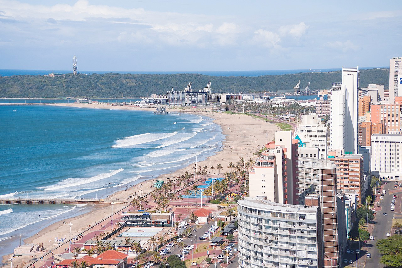 View over Durban
Climate Map
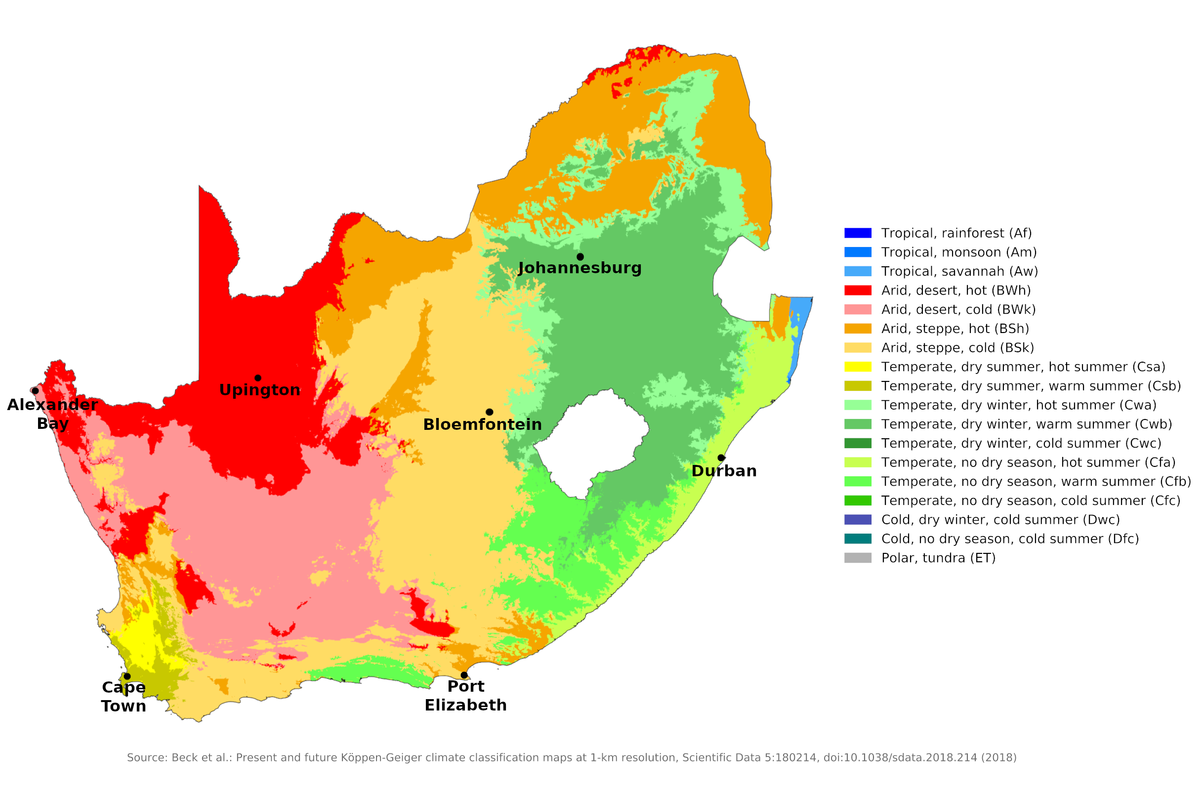 Climate map of South Africa
What is the climate of South Africa like?
South Africa extends from 22° S to 35° S at Cape Agulhas, the southernmost point of the African continent. Much of the interior consists of extensive plateaus, known in South Africa as the 'veld', ranging in elevation from 900 to 1,800 meters (3,000–6,000 ft). The interior is separated from the narrow coastal plain by a steep escarpment (The Great Escarpment) which forms high mountains to the east and south.
The climate in South Africa generally ranges from Mediterranean in the south-west corner of the country to temperate on the inner plateau and subtropical in the north-east. A small area in the northwest has a desert climate. Most of the country has warm sunny days and cool nights. Rainfall generally occurs in summer (November to March), although winter (June to August) rains are common in the southwest around the Cape of Good Hope. Temperatures are affected more than latitude by elevation, terrain, and ocean currents. Climatic conditions vary noticeably between east and west, mainly in response to the warm Agulhas current, which flows south along the Indian Ocean coast for several months a year, and the cold Benguela current, which flows north up the Atlantic coast from the frigid Southern Ocean that surrounds Antarctica. Air temperatures in Durban on the Indian Ocean are on average almost 6°C (10°F) warmer than temperatures at the same latitude on the Atlantic coast. The effects of these two currents can be seen even on the narrow peninsula of the Cape of Good Hope, where water temperatures on the eastern side average 4°C (7°F) higher than in the west. Both the southern latitude and elevation of the interior regions produce a temperate climate, leaving only the low-lying districts to the north along the border with Zimbabwe and Mozambique having a climate that is tropical. The southern part of South Africa lies sufficiently far south to be affected in winter by weather disturbances associated with the belt of westerlies in the Southern Ocean. As a result, a small part of the Western Cape province below the Great Escarpment has a Mediterranean climate, with mild, changeable winters, which receive most of the annual precipitation, and warm to hot, sunny summers. East of Cape Town this transitions into a region where there is some rain in all months but where temperature conditions are similar. In the coastal areas of KwaZulu-Natal and in the lowlands below the Great Escarpment to the Mozambique border, the climate becomes almost tropical; Winters are warmer and summer is the wetter season, although rain falls throughout the year. This coast is exposed to both the warm offshore waters and the southeast trade winds for most of the year. In contrast, the west coast north of about 32°S is a desert region with a remarkably small annual temperature range. This is because the cold Benguela Current cools the air and creates unfavorable atmospheric conditions for rain. Fog and low clouds are common on this coast. In the interior of South Africa there is a great contrast between East and West. Total precipitation is greatest in the east and gradually decreases towards the west, leaving much of western Gauteng, the North West and Northern Cape Province as semi-desert with low and unreliable precipitation. The wettest regions are the eastern parts of Gauteng and Free State, where both the elevation and exposure to the humid air coming from the Indian Ocean produce the heaviest and most reliable rainfall. Throughout the interior of the country, it rains mainly in the summer season, much of it in thunderstorms. Due to the elevation and "continental" influence, there is a wide daily and seasonal temperature variation, so winter frosts are common and snow is not unheard of above 1,500 meters (5,000 feet). Winters are mostly dry and sunny and summers are warm to hot. Most of South Africa has a very sunny climate with plenty of fine, calm weather. The southern coastal regions have their most unsettled and changeable weather in winter and the eastern coastal areas and inland have their most unsettled and rainy weather in summer. In some parts of South Africa, the climate is likely to cause great discomfort or stress. Daily hours of sunshine are high over most of the country, averaging eight to ten hours a day year-round. The cloudiest regions are the west and east coasts, especially in the summer months. Including the greater part of Gauteng (Pretoria, Johannesburg) and Free State (Bloemfontein). Most of this area is above 1,200 meters (4,000 feet). This is the most developed part of South Africa. As the climate of Johannesburg and Bloemfontein shows, the winters are dry and mild, but with often cold nights. Summers are warm with more frequent rains, but temperatures are rarely excessive. The low humidity and the many hours of sunshine ensure a pleasant climate almost all year round. Including much of Northern Cape and North West Province. The main feature of this large region is its low rainfall; Much of it is semi-desert or even desert. Apart from the low rainfall, the general weather and climate characteristics are similar to those of the eastern interior. Upington's climate is representative of much of the region. Including the western coast of Northern Cape and the far northwest of Western Cape The weather and climate in this desert, which continues north along the entire coast of neighboring Namibia, is unusual and very distinctive. The region receives very little rain and is a complete desert, but temperatures are kept low most of the time by the cold Benguela current. On some days of the month, especially in winter, midday temperatures rise quite high when the 'berg' winds blow from the inland. This is a föhn-like wind that brings with it very dry air, which is heated as it descends towards the coast. Aside from the rare rain showers and frequent coastal fog, the 'berg' is almost the only weather feature of this arid region (see the climate for Alexander Bay in the far northwest). Including the coastal lowlands and southern slopes of the mountains around Cape Town. The coastal lowlands and southern slopes of the mountains around Cape Town have mild and generally wet winters with very changeable weather and dry, consistent summers similar to climates in much of the Mediterranean or California. Summers are not completely dry and occasional rainstorms occur. Cape Town is representative of this region, but some sheltered areas inland are warmer and drier. This was the area first settled by Europeans in the 17th century; French Huguenot settlers introduced the grapevine, which thrives in this climate. Including the lowlands and hilly region below the Great Escarpment in Eastern Cape Province. The weather and climate of this region lies between that of the southwestern Cape and the eastern coastal regions. The main difference is that rainfall is well distributed throughout the year and weather disturbances can occur in both winter and summer (see Port Elizabeth climate). Including coastal and inland KwaZulu-Natal. This is the part of southern Africa where the climate is closest to tropical. Summers are warm and humid on the coast, particularly in northern Zululand, where conditions are similar to southern Mozambique. Summer is the wettest season, but some rain falls in all months. Durban is representative of the coastal lowlands. The heat and humidity here are tempered by daily sea breezes, but conditions are often muggy in summer. Winters are mild to warm. Inland and at mid-elevations below the Great Escarpment, temperatures are lower, particularly in winter, but rainfall is greater.The Eastern Interior or High Veld
Climate data for Johannesburg (1961–1990) Month Jan Feb Mar Apr May Jun Jul Aug Sep Oct Nov Dec Year Average high °C (°F) 25.6
(78.1)25.1
(77.2)24.0
(75.2)21.1
(70.0)18.9
(66.0)16.0
(60.8)16.7
(62.1)19.4
(66.9)22.8
(73.0)23.8
(74.8)24.2
(75.6)25.2
(77.4)21.9
(71.4)Daily mean °C (°F) 19.5
(67.1)19.0
(66.2)18.0
(64.4)15.3
(59.5)12.6
(54.7)9.6
(49.3)10.0
(50.0)12.5
(54.5)15.9
(60.6)17.1
(62.8)17.9
(64.2)19.0
(66.2)15.5
(59.9)Average low °C (°F) 14.7
(58.5)14.1
(57.4)13.1
(55.6)10.3
(50.5)7.2
(45.0)4.1
(39.4)4.1
(39.4)6.2
(43.2)9.3
(48.7)11.2
(52.2)12.7
(54.9)13.9
(57.0)10.1
(50.2)Average precipitation mm (inches) 125
(4.9)90
(3.5)91
(3.6)54
(2.1)13
(0.5)9
(0.4)4
(0.2)6
(0.2)27
(1.1)72
(2.8)117
(4.6)105
(4.1)713
(28.1)Source: World Meteorological Organization Climate data for Bloemfontein (1961−1990) Month Jan Feb Mar Apr May Jun Jul Aug Sep Oct Nov Dec Year Average high °C (°F) 30.8
(87.4)28.8
(83.8)26.9
(80.4)23.1
(73.6)20.1
(68.2)16.8
(62.2)17.4
(63.3)20.0
(68.0)24.0
(75.2)26.1
(79.0)28.1
(82.6)30.1
(86.2)24.4
(75.9)Daily mean °C (°F) 22.8
(73.0)21.4
(70.5)19.2
(66.6)14.9
(58.8)10.7
(51.3)6.9
(44.4)7.2
(45.0)10.1
(50.2)14.6
(58.3)17.5
(63.5)19.9
(67.8)21.9
(71.4)15.6
(60.1)Average low °C (°F) 15.3
(59.5)14.7
(58.5)12.4
(54.3)7.7
(45.9)2.5
(36.5)−1.5
(29.3)−1.9
(28.6)0.5
(32.9)5.2
(41.4)9.1
(48.4)11.7
(53.1)13.8
(56.8)7.5
(45.5)Average precipitation mm (inches) 83
(3.3)111
(4.4)72
(2.8)56
(2.2)17
(0.7)12
(0.5)8
(0.3)15
(0.6)24
(0.9)43
(1.7)58
(2.3)60
(2.4)559
(22.0)Source: NOAA The Western Interior
Climate data for Upington (1961−1990) Month Jan Feb Mar Apr May Jun Jul Aug Sep Oct Nov Dec Year Average high °C (°F) 35.5
(95.9)34.4
(93.9)32.1
(89.8)27.8
(82.0)24.0
(75.2)20.5
(68.9)20.8
(69.4)22.9
(73.2)26.8
(80.2)29.6
(85.3)32.7
(90.9)34.7
(94.5)28.5
(83.3)Daily mean °C (°F) 27.8
(82.0)26.9
(80.4)24.7
(76.5)20.2
(68.4)15.7
(60.3)12.1
(53.8)11.9
(53.4)14.0
(57.2)18.1
(64.6)21.4
(70.5)24.7
(76.5)26.9
(80.4)20.4
(68.7)Average low °C (°F) 19.8
(67.6)19.5
(67.1)17.8
(64.0)13.3
(55.9)8.3
(46.9)4.8
(40.6)4.1
(39.4)5.6
(42.1)9.4
(48.9)12.9
(55.2)16.3
(61.3)18.6
(65.5)12.5
(54.5)Average precipitation mm (inches) 24
(0.9)35
(1.4)37
(1.5)26
(1.0)10
(0.4)4
(0.2)2
(0.1)4
(0.2)4
(0.2)9
(0.4)17
(0.7)17
(0.7)189
(7.4)Source: NOAA The Namib or Coastal Desert
Climate data for Alexander Bay (1961−1990) Month Jan Feb Mar Apr May Jun Jul Aug Sep Oct Nov Dec Year Average high °C (°F) 24.3
(75.7)24.0
(75.2)24.3
(75.7)23.5
(74.3)22.9
(73.2)21.5
(70.7)20.6
(69.1)20.1
(68.2)20.6
(69.1)21.5
(70.7)22.7
(72.9)23.4
(74.1)22.5
(72.5)Daily mean °C (°F) 19.1
(66.4)18.8
(65.8)18.3
(64.9)17.0
(62.6)15.7
(60.3)14.8
(58.6)13.8
(56.8)13.7
(56.7)14.5
(58.1)15.7
(60.3)17.1
(62.8)18.2
(64.8)16.4
(61.5)Average low °C (°F) 15.1
(59.2)15.1
(59.2)14.2
(57.6)12.5
(54.5)10.6
(51.1)9.9
(49.8)8.7
(47.7)8.9
(48.0)9.9
(49.8)11.3
(52.3)12.9
(55.2)14.2
(57.6)11.9
(53.4)Average precipitation mm (inches) 1
(0.0)2
(0.1)2
(0.1)4
(0.2)4
(0.2)8
(0.3)5
(0.2)6
(0.2)3
(0.1)0
(0)0
(0)2
(0.1)37
(1.5)Source: NOAA Southwest Cape
Climate data for Cape Town (1961–1990) Month Jan Feb Mar Apr May Jun Jul Aug Sep Oct Nov Dec Year Average high °C (°F) 26.1
(79.0)26.5
(79.7)25.4
(77.7)23.0
(73.4)20.3
(68.5)18.1
(64.6)17.5
(63.5)17.8
(64.0)19.2
(66.6)21.3
(70.3)23.5
(74.3)24.9
(76.8)22.0
(71.5)Daily mean °C (°F) 20.4
(68.7)20.4
(68.7)19.2
(66.6)16.9
(62.4)14.4
(57.9)12.5
(54.5)11.9
(53.4)12.4
(54.3)13.7
(56.7)15.6
(60.1)17.9
(64.2)19.5
(67.1)16.2
(61.2)Average low °C (°F) 15.7
(60.3)15.6
(60.1)14.2
(57.6)11.9
(53.4)9.4
(48.9)7.8
(46.0)7.0
(44.6)7.5
(45.5)8.7
(47.7)10.6
(51.1)13.2
(55.8)14.9
(58.8)11.4
(52.5)Average precipitation mm (inches) 15
(0.6)17
(0.7)20
(0.8)41
(1.6)69
(2.7)93
(3.7)82
(3.2)77
(3.0)40
(1.6)30
(1.2)14
(0.6)17
(0.7)515
(20.4)Source: World Meteorological Organization The Eastern Cape
Climate data for Port Elizabeth (1961−1990) Month Jan Feb Mar Apr May Jun Jul Aug Sep Oct Nov Dec Year Average high °C (°F) 25.4
(77.7)25.4
(77.7)24.6
(76.3)23.0
(73.4)21.7
(71.1)20.3
(68.5)19.7
(67.5)19.6
(67.3)20.0
(68.0)20.8
(69.4)22.3
(72.1)24.3
(75.7)22.3
(72.1)Daily mean °C (°F) 21.3
(70.3)21.2
(70.2)20.3
(68.5)18.2
(64.8)16.1
(61.0)14.3
(57.7)13.9
(57.0)14.3
(57.7)15.4
(59.7)16.7
(62.1)18.2
(64.8)20.1
(68.2)17.5
(63.5)Average low °C (°F) 17.9
(64.2)17.9
(64.2)16.9
(62.4)14.3
(57.7)11.5
(52.7)9.2
(48.6)8.8
(47.8)9.8
(49.6)11.4
(52.5)13.1
(55.6)14.6
(58.3)16.4
(61.5)13.5
(56.3)Average precipitation mm (inches) 36
(1.4)40
(1.6)54
(2.1)58
(2.3)59
(2.3)62
(2.4)47
(1.9)64
(2.5)62
(2.4)59
(2.3)49
(1.9)34
(1.3)624
(24.6)Source: NOAA The Eastern Coastlands and Low Veld
Climate data for Durban (1961–1990) Month Jan Feb Mar Apr May Jun Jul Aug Sep Oct Nov Dec Year Average high °C (°F) 27.8
(82.0)28.0
(82.4)27.7
(81.9)26.1
(79.0)24.5
(76.1)23.0
(73.4)22.6
(72.7)22.8
(73.0)23.3
(73.9)24.0
(75.2)25.2
(77.4)26.9
(80.4)25.2
(77.4)Daily mean °C (°F) 24.1
(75.4)24.3
(75.7)23.7
(74.7)21.6
(70.9)19.1
(66.4)16.6
(61.9)16.5
(61.7)17.7
(63.9)19.2
(66.6)20.1
(68.2)21.4
(70.5)23.1
(73.6)20.6
(69.1)Average low °C (°F) 21.1
(70.0)21.1
(70.0)20.3
(68.5)17.4
(63.3)13.8
(56.8)10.6
(51.1)10.5
(50.9)12.5
(54.5)15.3
(59.5)16.8
(62.2)18.3
(64.9)20.0
(68.0)16.5
(61.7)Average precipitation mm (inches) 134
(5.3)113
(4.4)120
(4.7)73
(2.9)59
(2.3)38
(1.5)39
(1.5)62
(2.4)73
(2.9)98
(3.9)108
(4.3)102
(4.0)1,019
(40.1)Source: World Meteorological Organization References
The Climate of
South Africa
In summary:
The climate of South Africa ranges from Mediterranean-like in the southwest to temperate in the interior plateau, to subtropical in the northeast. The average daily temperature at Durban, on the east coast, ranges from 17°C (62°F) in July to 24°C (75°F) in February. Temperatures are cooler in the highlands: at Johannesburg, the average is 10°C (49°F) in June and July and 20°C (67°F) in January. On the high veld there are sharp differences of temperature between day and night, but there is less daily fluctuation nearer the coast.
Rainfall is unpredictable in large parts of the country, and prolonged droughts occur in many areas. While the mean annual rainfall is 500 mm (20 in), the northwest receives less than 200 mm (8 in) but southeastern areas get more than 1000 mm (40 in). Much of South Africa gets its rain in the summer months, but the western coast is a winter rain area. Along the Cape south coast, rain falls during both seasons.