The Climate of
Namibia
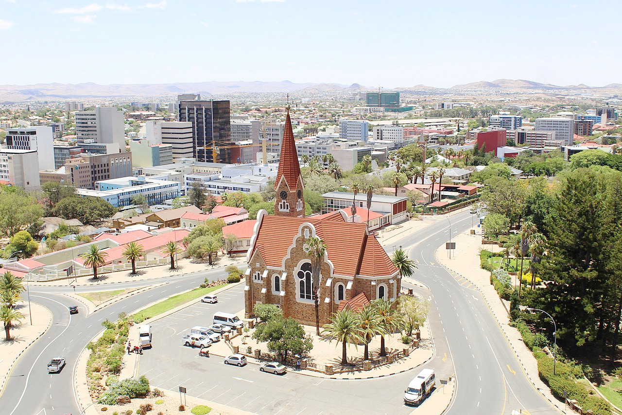 View over Windhoek
Climate Map
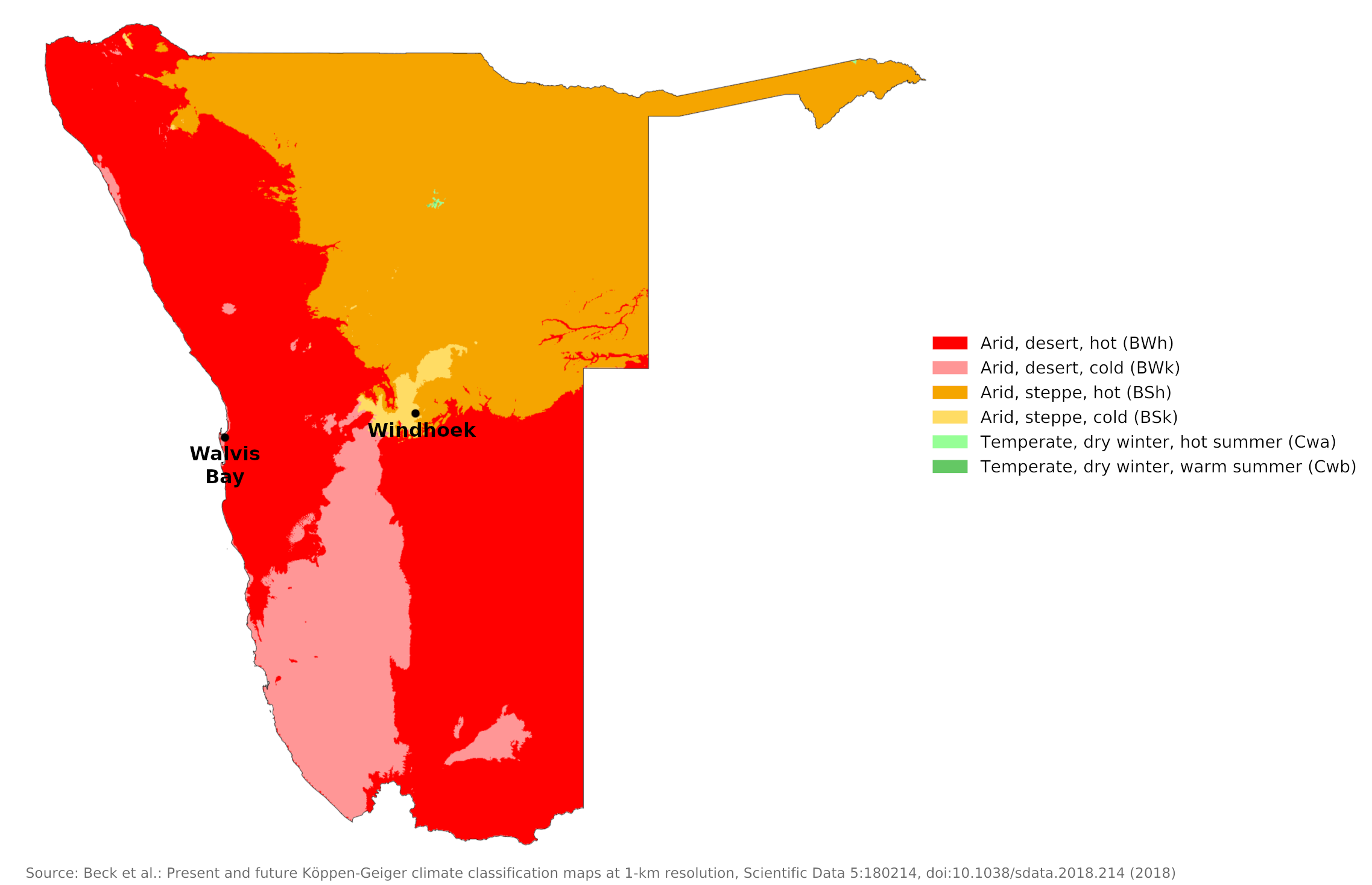 Climate map of the Namibia
What is the climate of Namibia like?
Namibia is a large country almost two-thirds the size of the Republic of South Africa. It is bordered by Angola on the north, Botswana on the east, and South Africa on the south. It is very sparsely populated and most of it is desert or semi-desert.
Namibia's climate is the driest in southern Africa, with sunny, warm days and cool nights, especially during the winter months. The average temperature along the coast is the summer is 23°C (73°F); in winter, the average temperature is 13°C (55°F). Frost may occur in July in any part of the country, although it generally is light. The fertile northern strip is always warmer, having a climate similar to that of southern Angola.
Much of Namibia is a land of perennial drought. Namibia's major physical problem is the general scarcity, irregularity, and uneven distribution of rainfall. Over 70 percent of the country the average rainfall is below 400 millimeters (16 inches) annually, the minimum for dryland agriculture in a hot climate. The entire coast, part of the Namib desert shared with the west coast of South Africa, receives very little rain and is a complete desert.
Except for the highest mountain areas, the country's lowest mean temperatures occur in the coastal Namib region. Temperatures are kept low by the cold Benguela current from the South Atlantic. Walvis Bay has a mean temperature of 18°C (64°F) in February, the region's warmest month; during its coldest month of August, the mean temperature is 13°C (56°F).
On a few days each month, particularly in winter, midday temperatures rise quite high when the berg wind blows from the interior. This is a föhn-type wind bringing very dry air which is heated as it descends to the coast. This gives the coast a relatively high average winter temperature. Apart from the rare shower of rain and the frequent coastal fog, the berg is almost the only weather feature of this arid region.
| Climate data for Walvis Bay | |||||||||||||
|---|---|---|---|---|---|---|---|---|---|---|---|---|---|
| Month | Jan | Feb | Mar | Apr | May | Jun | Jul | Aug | Sep | Oct | Nov | Dec | Year |
| Average high °C (°F) | 20.0 (68.0) | 20.3 (68.5) | 19.6 (67.3) | 18.6 (65.5) | 19.0 (66.2) | 18.8 (65.8) | 17.8 (64.0) | 16.4 (61.5) | 15.8 (60.4) | 16.6 (61.9) | 17.7 (63.9) | 19.0 (66.2) | 18.3 (64.9) |
| Daily mean °C (°F) | 17.6 (63.7) | 17.9 (64.2) | 17.2 (63.0) | 15.7 (60.3) | 15.6 (60.1) | 15.2 (59.4) | 14.1 (57.4) | 13.2 (55.8) | 13.2 (55.8) | 14.0 (57.2) | 15.3 (59.5) | 16.6 (61.9) | 15.5 (59.9) |
| Average low °C (°F) | 15.2 (59.4) | 15.5 (59.9) | 14.7 (58.5) | 12.9 (55.2) | 12.1 (53.8) | 11.4 (52.5) | 10.3 (50.5) | 10.1 (50.2) | 10.7 (51.3) | 11.5 (52.7) | 12.9 (55.2) | 14.2 (57.6) | 12.6 (54.7) |
| Average precipitation mm (inches) | 1.0 (0.04) | 2.0 (0.08) | 5.0 (0.20) | 1.0 (0.04) | 1.0 (0.04) | 2.0 (0.08) | 0.0 (0.0) | 0.2 (0.01) | 0.1 (0.00) | 0.1 (0.00) | 0.7 (0.03) | 0.1 (0.00) | 13.2 (0.52) |
| Source: Deutscher Wetterdienst | |||||||||||||
The interior of the country is not affected by coastal conditions. In the highland region around Windhoek much of the land is above 1,000 meters (3,000 feet). Here the average monthly temperatures for the warmest month, December, is 24°C (74°F). In July, the coldest month, the average temperature is 13°C (56°F).
| Climate data for Windhoek | |||||||||||||
|---|---|---|---|---|---|---|---|---|---|---|---|---|---|
| Month | Jan | Feb | Mar | Apr | May | Jun | Jul | Aug | Sep | Oct | Nov | Dec | Year |
| Average high °C (°F) | 30.0 (86.0) | 28.6 (83.5) | 27.2 (81.0) | 25.6 (78.1) | 22.7 (72.9) | 20.2 (68.4) | 20.5 (68.9) | 23.4 (74.1) | 26.5 (79.7) | 29.1 (84.4) | 29.6 (85.3) | 30.7 (87.3) | 26.1 (79.0) |
| Daily mean °C (°F) | 23.3 (73.9) | 22.1 (71.8) | 21.0 (69.8) | 18.9 (66.0) | 15.8 (60.4) | 13.2 (55.8) | 13.1 (55.6) | 15.8 (60.4) | 19.3 (66.7) | 21.7 (71.1) | 22.5 (72.5) | 23.5 (74.3) | 19.1 (66.4) |
| Average low °C (°F) | 17.2 (63.0) | 16.5 (61.7) | 15.4 (59.7) | 12.8 (55.0) | 9.2 (48.6) | 6.7 (44.1) | 6.3 (43.3) | 8.6 (47.5) | 11.9 (53.4) | 14.6 (58.3) | 15.6 (60.1) | 16.9 (62.4) | 12.7 (54.9) |
| Average precipitation mm (inches) | 78.1 (3.07) | 80.3 (3.16) | 78.7 (3.10) | 37.7 (1.48) | 6.6 (0.26) | 1.2 (0.05) | 0.7 (0.03) | 0.9 (0.04) | 2.8 (0.11) | 11.8 (0.46) | 26.9 (1.06) | 41.7 (1.64) | 367.4 (14.46) |
| Source: Deutscher Wetterdienst | |||||||||||||
The highest temperatures occur in the south where daytime tempertures reach 35°C (95°F) in January, and often exceed 40°C (104°F). The interior as well is marked by low rainfall, and much of it is semi-desert or desert. Keetmanshoop is typical of the warm and dry conditions of the south.
| Climate data for Keetmanshoop | |||||||||||||
|---|---|---|---|---|---|---|---|---|---|---|---|---|---|
| Month | Jan | Feb | Mar | Apr | May | Jun | Jul | Aug | Sep | Oct | Nov | Dec | Year |
| Average high °C (°F) | 34.8 (94.6) | 34.0 (93.2) | 32.2 (90.0) | 28.8 (83.8) | 25.0 (77.0) | 21.7 (71.1) | 21.3 (70.3) | 23.5 (74.3) | 27.2 (81.0) | 30.1 (86.2) | 32.4 (90.3) | 34.5 (94.1) | 28.8 (83.8) |
| Daily mean °C (°F) | 26.9 (80.4) | 26.7 (80.1) | 25.0 (77.0) | 21.6 (70.9) | 17.7 (63.9) | 14.4 (57.9) | 13.9 (57.0) | 15.5 (59.9) | 19.0 (66.2) | 21.9 (71.4) | 24.1 (75.4) | 26.1 (79.0) | 21.1 (69.9) |
| Average low °C (°F) | 19.0 (66.2) | 19.3 (66.7) | 17.8 (64.0) | 14.4 (57.9) | 10.4 (50.7) | 7.0 (44.6) | 6.4 (43.5) | 7.5 (45.5) | 10.7 (51.3) | 13.7 (56.7) | 15.7 (60.3) | 17.6 (63.7) | 13.3 (55.9) |
| Average precipitation mm (inches) | 24 (0.9) | 42 (1.7) | 36 (1.4) | 15 (0.6) | 5 (0.2) | 2 (0.1) | 1 (0.0) | 1 (0.0) | 3 (0.1) | 6 (0.2) | 11 (0.4) | 13 (0.5) | 159 (6.1) |
| Source: Tabulation of Climate Statistics for Selected Stations in Namibia | |||||||||||||
Generally, the entire coastal region receives an average of less than two inches of rainfall annually. Over the central plateau, rainfall patterns improve somewhat from the southwest to the northeast, but only along the Okavango River in the north and in the Caprivi Strip is rainfall favorable for agriculture. Rundu is typical of the warmer and wetter conditions in the north of the country.
| Climate data for Rundu | |||||||||||||
|---|---|---|---|---|---|---|---|---|---|---|---|---|---|
| Month | Jan | Feb | Mar | Apr | May | Jun | Jul | Aug | Sep | Oct | Nov | Dec | Year |
| Average high °C (°F) | 31.1 (88.0) | 30.9 (87.6) | 31.4 (88.5) | 30.7 (87.3) | 28.9 (84.0) | 26.5 (79.7) | 26.1 (79.0) | 29.5 (85.1) | 33.1 (91.6) | 34.6 (94.3) | 33.9 (93.0) | 32.6 (90.7) | 30.8 (87.4) |
| Daily mean °C (°F) | 25.2 (77.4) | 25.0 (77.0) | 24.9 (76.8) | 22.9 (73.2) | 19.9 (67.8) | 16.8 (62.2) | 16.8 (62.2) | 20.0 (68.0) | 24.2 (75.6) | 27.0 (80.6) | 26.8 (80.2) | 26.3 (79.3) | 23.0 (73.4) |
| Average low °C (°F) | 19.3 (66.7) | 19.1 (66.4) | 18.4 (65.1) | 15.1 (59.2) | 10.8 (51.4) | 7.1 (44.8) | 7.4 (45.3) | 10.4 (50.7) | 15.3 (59.5) | 19.3 (66.7) | 19.7 (67.5) | 20.0 (68.0) | 15.2 (59.3) |
| Average precipitation mm (inches) | 152.3 (6.00) | 138.1 (5.44) | 84.6 (3.33) | 28.6 (1.13) | 2.2 (0.09) | 0.1 (0.00) | 0.0 (0.0) | 0.2 (0.01) | 3.1 (0.12) | 21.1 (0.83) | 53.4 (2.10) | 80.8 (3.18) | 564.5 (22.23) |
| Source: Tabulation of Climate Statistics for Selected Stations in Namibia | |||||||||||||
The rainy season is from November to March, with most of the rainfall occurring from January to March. Rain typically occurs during widely scattered, brief thunderstorms. Average annual rainfall along the Atlantic Coast is less than 50 millimeters (2 inches). About 350 millimeters (14 inches) of rain fall in the central highlands. The country's highest rainfall occurs in the northeast, where there is woodland savannah featuring dense vegetation covering the plains. Yearly rainfall levels up to 700 millimeters (28 inches) can be found here.
Because of the erratic rainfall, droughts are frequent; some areas of the country may go years without receiving any rain. Except in the northern and southern extremities, there are no perennial rivers; all others flow intermittently. The whole region has about forty natural springs, and shallow ponds or pans occur sporadically. The largest of these is the Etosha Pan in the extreme north; This seventy-by-thirty-mile depression receives the summer drainage of the North. As with other temporary bodies of water, it is subject to evaporation brought about by an arid climate and seasonal rainfall patterns.
Like most interior deserts Namibia's has a very sunny climate. Usually, the atmosphere is exceedingly dry, but dense fogs occur frequently along the coastline.
References
- E. A. Pearce, Charles Gordon Smith, (1990) The Hutchinson World Weather Guide, John Murray Press. ISBN 1859863426
- Timothy L. Gall, (ed.), (2003), Worldmark Encyclopedia of the Nations, Eleventh Edition, Thomson Gale
- The American University, (1970), Area Handbook for the Republic of South Africa. United States Government Printing Office.
- Hugh Chisholm, (ed.), (1911), Encyclopædia Britannica, Eleventh edition, Cambridge University Press
The Climate of
Namibia
In summary:
Namibia's climate is the driest in southern Africa, with sunny, warm days and cooler nights, especially during the winter months. Along the coast, the average temperature ranges from 23°C (73°F) in summer to 13°C (55°F) in winter. Inland, the temperatures may be somewhat higher, except at the higher elevations.
There is little rainfall in Namibia. The rainy season is from November to March, with most of the rainfall occurring from January to March. Rain typically occurs during widely scattered, brief thunderstorms. The entire coast receives very little rain and is a complete desert. The country's highest rainfall occurs in the northeast.