The Climate of
Tanzania
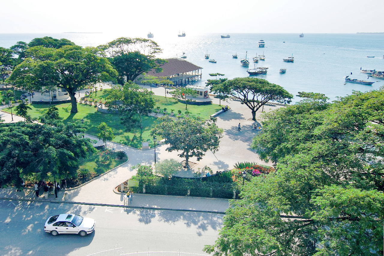 Forodhani Park, Zanzibar
Climate Map
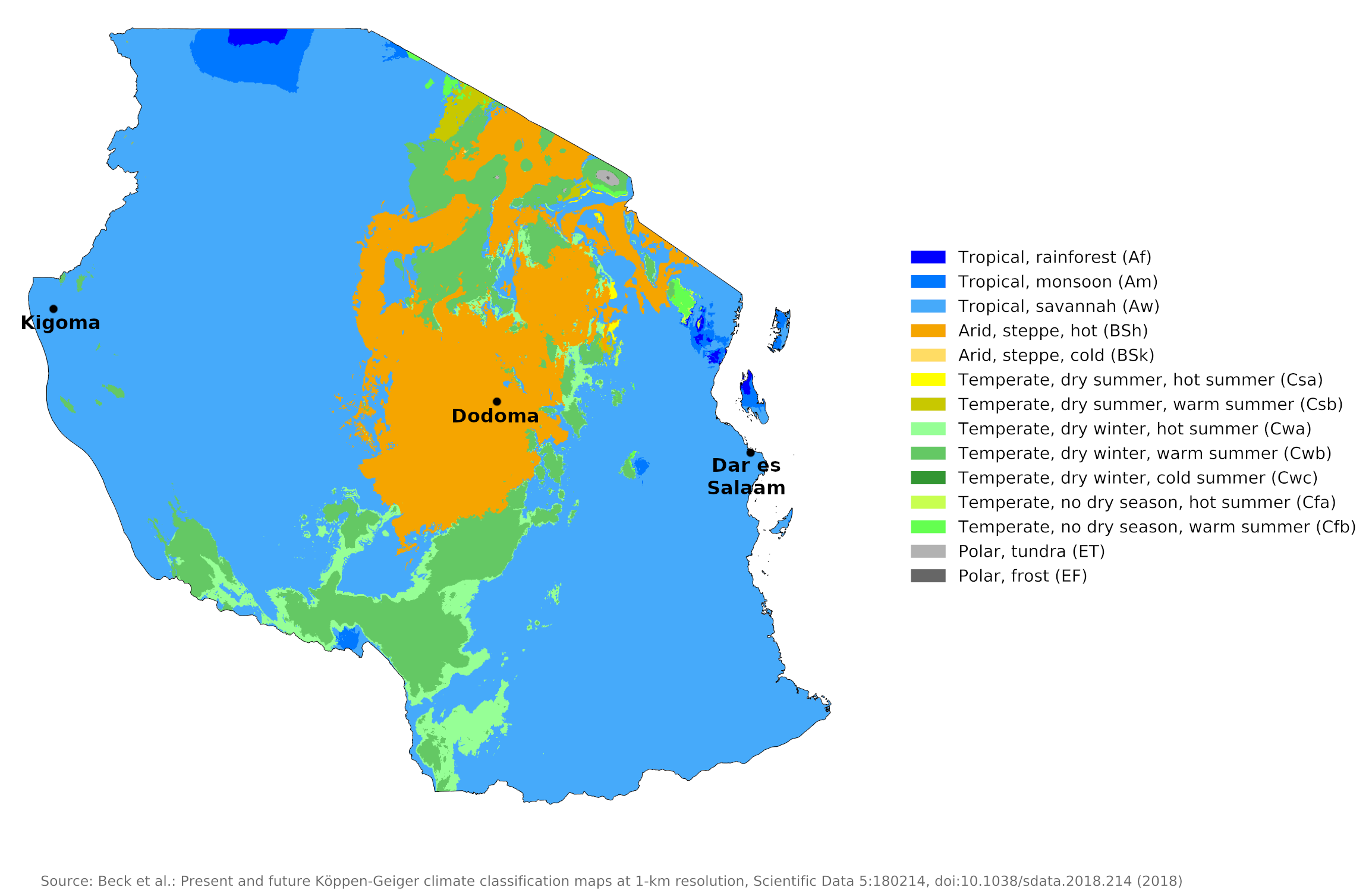 Climate map of Tanzania
What is the climate of Tanzania like?
Tanzania is a country in East Africa. It lies south of the equator between 1° and 12°S. It has a long coastline on the Indian Ocean. It is bordered by Kenya and Uganda on the north, by Mozambique, Malawi, and Zambia on the south and by the Democratic Republic of Congo on the west. There is a fairly narrow coastal plain to the east, but most of the interior consists of a plateau 900 to 1,500 meters (3,000–5,000 feet) above sea level. There are a number of mountain ranges that rise between 2,100 and 3,000 meters (7,000–10,000 feet). In the north of the country, the isolated peak of Mount Kilimanjaro, the highest mountain in Africa, rises to almost 6,000 meters (20,000 feet). It has a permanent snow cap and small glaciers.
Tanzania is just south of the equator; As such, its climate is mostly tropical, but above 1,000 meters (3,000 feet) this is modified by reduced temperatures where mean daily maximums range between 22°C and 30°C (72°F and 90°F). Altitude also plays a large role in determining rainfall patterns, with the higher elevations receiving more precipitation. Generally the total amount of rainfall is not very great. Only about half of the country receives more than 750 millimeters (30 inches) annually. There are, however, great variations, from more than 2,500 millimeters (100 inches) annually just northwest of Lake Nyasa to less than 500 millimeters (20 inches) in parts of the hot and dry Central Plateau and the Masai Steppe.
Seasons are determined by the air-streams coming from the Indian Ocean and southern Asia. In northern and eastern Tanzania, the rainy season is divided into two parts: the short rains (or "Vuli") and the long rains (or "Masika"). The former falls in the months of October, November, December; the latter from March to May, when the heaviest downpours occur. September is the driest month, although there are occasional showers. The Southern Coastal District experiences occasional heavy rains and high winds associated with tropical cyclones in the South Indian Ocean. Inland there is generally a rainy season, with rain beginning in November and ending in April or May; the rest of the year is dry. In many inner districts, the rainy season sometimes passes without regular heavy rains, resulting in severe droughts.
Although the weather on the coast is often rather oppressive due to higher temperatures, particularly at night, and high humidity, conditions here are not persistently uncomfortable thanks to regular daily sea breezes. Inland, lower humidity and cooler nighttime temperatures mean heat stress is rare, although daytime temperatures are fairly high and sun is plentiful. Much of Tanzania has a very sunny climate with many places averaging seven to ten hours of sunshine per day, with fewer hours during the rainy season. As in most other tropical countries, the year is usually divided into a rainy and dry season, since the terms winter and summer are not very meaningful in terms of temperature.
The Coast
On the coast a warm and humid climate prevails. The coastal area is tropical with average temperatures around 26°C (78°F). Dar es Salaam is typical of the climate on the coast. The offshore islands of Pemba and Zanzibar have an even more tropical climate, with higher temperatures and heavier and more reliable rainfall than most inland areas.
Average annual rainfall is over 1,000 millimeters (40 inches) almost everywhere on the coast and up to 1,500 millimeters (60 inches) in the wetter places. This can be compared to the annual rainfall of 500 to 1,000 millimeters (20–40 inches) over most of the interior.
| Climate data for Dar es Salaam | |||||||||||||
|---|---|---|---|---|---|---|---|---|---|---|---|---|---|
| Month | Jan | Feb | Mar | Apr | May | Jun | Jul | Aug | Sep | Oct | Nov | Dec | Year |
| Average high °C (°F) | 31.8 (89.2) | 32.4 (90.3) | 32.1 (89.8) | 30.7 (87.3) | 29.8 (85.6) | 29.3 (84.7) | 28.9 (84.0) | 29.4 (84.9) | 30.3 (86.5) | 30.9 (87.6) | 31.4 (88.5) | 31.6 (88.9) | 30.7 (87.3) |
| Daily mean °C (°F) | 27.7 (81.9) | 27.9 (82.2) | 27.5 (81.5) | 26.6 (79.9) | 25.6 (78.1) | 24.3 (75.7) | 23.6 (74.5) | 23.8 (74.8) | 24.4 (75.9) | 25.3 (77.5) | 26.4 (79.5) | 27.2 (81.0) | 25.9 (78.5) |
| Average low °C (°F) | 23.5 (74.3) | 23.3 (73.9) | 22.8 (73.0) | 22.4 (72.3) | 21.3 (70.3) | 19.2 (66.6) | 18.2 (64.8) | 18.1 (64.6) | 18.4 (65.1) | 19.7 (67.5) | 21.3 (70.3) | 22.8 (73.0) | 20.9 (69.6) |
| Average precipitation mm (inches) | 76.3 (3.00) | 54.9 (2.16) | 138.1 (5.44) | 254.2 (10.01) | 197.8 (7.79) | 42.9 (1.69) | 25.6 (1.01) | 24.1 (0.95) | 22.8 (0.90) | 69.3 (2.73) | 125.9 (4.96) | 117.8 (4.64) | 1,149.7 (45.26) |
| Source: World Meteorological Organization | |||||||||||||
Central plateau
Further inland, the central plateau is hot and dry with temperatures that vary with season and time of day. In the more temperate highlands, days are warm but nights are cool. The climate of Dodoma is typical of this region; here the climate is less strenuous than the coastal regions. Annual rainfall in the interior is notoriously unreliable and much of it is very sporadic, both in terms of time and location.
| Climate data for Dodoma | |||||||||||||
|---|---|---|---|---|---|---|---|---|---|---|---|---|---|
| Month | Jan | Feb | Mar | Apr | May | Jun | Jul | Aug | Sep | Oct | Nov | Dec | Year |
| Average high °C (°F) | 29.4 (84.9) | 29.4 (84.9) | 29.0 (84.2) | 28.7 (83.7) | 28.0 (82.4) | 27.1 (80.8) | 26.5 (79.7) | 27.3 (81.1) | 29.0 (84.2) | 30.5 (86.9) | 30.1 (86.2) | 30.4 (86.7) | 28.8 (83.8) |
| Daily mean °C (°F) | 24.0 (75.2) | 24.0 (75.2) | 23.7 (74.7) | 23.3 (73.9) | 22.3 (72.1) | 20.8 (69.4) | 20.1 (68.2) | 20.8 (69.4) | 22.2 (72.0) | 23.7 (74.7) | 24.2 (75.6) | 24.6 (76.3) | 22.7 (72.9) |
| Average low °C (°F) | 18.6 (65.5) | 18.6 (65.5) | 18.3 (64.9) | 17.9 (64.2) | 16.5 (61.7) | 14.4 (57.9) | 13.6 (56.5) | 14.2 (57.6) | 15.3 (59.5) | 16.9 (62.4) | 18.3 (64.9) | 18.8 (65.8) | 16.5 (61.7) |
| Average precipitation mm (inches) | 133.7 (5.26) | 144.5 (5.69) | 113.9 (4.48) | 57.8 (2.28) | 5.3 (0.21) | 0.1 (0.00) | 0.03 (0.00) | 0.01 (0.00) | 0.01 (0.00) | 2.08 (0.08) | 26.25 (1.03) | 123.28 (4.85) | 606.96 (23.90) |
| Source: World Meteorological Organization | |||||||||||||
The Great Lakes
Rainfall increases somewhat and also becomes more reliable towards the west and around the shores of the three major lakes bordering Tanzania: Lake Victoria, Lake Tanganyika and Lake Malawi (see the climate for Kigoma on Lake Tanganyika).
| Climate data for Kigoma | |||||||||||||
|---|---|---|---|---|---|---|---|---|---|---|---|---|---|
| Month | Jan | Feb | Mar | Apr | May | Jun | Jul | Aug | Sep | Oct | Nov | Dec | Year |
| Average high °C (°F) | 27 (80) | 27 (81) | 27 (81) | 27 (81) | 28 (83) | 28 (83) | 28 (83) | 29 (84) | 29 (85) | 29 (84) | 27 (80) | 26 (79) | 28 (82) |
| Daily mean °C (°F) | 23.1 (73.5) | 23 (74) | 23 (74) | 23 (74) | 24 (75) | 23.1 (73.5) | 23 (73) | 23 (74) | 24.7 (76.5) | 24.7 (76.5) | 23 (74) | 23 (73) | 23.4 (74.3) |
| Average low °C (°F) | 19 (67) | 19 (67) | 19 (67) | 19 (67) | 19 (67) | 18 (64) | 17 (63) | 18 (64) | 20 (68) | 21 (69) | 20 (68) | 19 (67) | 19 (67) |
| Average precipitation mm (inches) | 120 (4.8) | 130 (5) | 150 (5.9) | 130 (5.1) | 43 (1.7) | 5.1 (0.2) | 2.5 (0.1) | 5.1 (0.2) | 18 (0.7) | 48 (1.9) | 140 (5.6) | 130 (5.3) | 921.7 (36.5) |
| Source: Weatherbase.com | |||||||||||||
References
- E. A. Pearce, Charles Gordon Smith, (1990) The Hutchinson World Weather Guide, John Murray Press. ISBN 1859863426
- Timothy L. Gall, (ed.), (2003), Worldmark Encyclopedia of the Nations, Eleventh Edition, Thomson Gale
- The American University, (1978), Area Handbook Series: Tanzania: a country study. United States Government Printing Office.
- Hugh Chisholm, (ed.), (1911), Encyclopædia Britannica, Eleventh edition, Cambridge University Press
The Climate of
Tanzania
In summary:
Tanzania has a tropical climate, becoming temperate in the highlands. The coast is hot and humid with average temperatures of about 26°C (78°F). Further inland, the central plateau is hot and dry with temperatures that vary by season, the warmest period being between November and February (25°C or 77°F) and coolest between May and August (20°C or 68°F). In the highlands the climate is temperate, temperatures range between 10°C and 20°C (50°F and 68°F).
Over most of the country there is a single rainy season with the heaviest falls between November and April; the period May to October is dry and sunny. The coastal region gets its main rain falling between March and May. Annual rainfall averages 1000 to 1900 mm (40 to 76 in) on the coast to only 500 to 760 mm (20 to 30 in) inland.