The Geography of
Peru
Peru's natural diversity ranges from parched coastal desert to sweltering tropical rain forest. Between these two extreme environments, the towering Andes soar to snow-covered, glacier-scoured peaks whose height is topped only by Asia's Himalayas. Coastal Peru gazes westward across the seemingly endless expanse of the Pacific Ocean. Only 100 miles (160 kilometers) inland, on the eastern slopes of the Andes, rise the headwaters of the world’s greatest river, the Amazon, which flows eastward to the Atlantic. Peru can also boast of many historical sites, including the magnificent ruins of Machu Picchu or the ancient and mysterious Nazca Lines.
Contents
Map
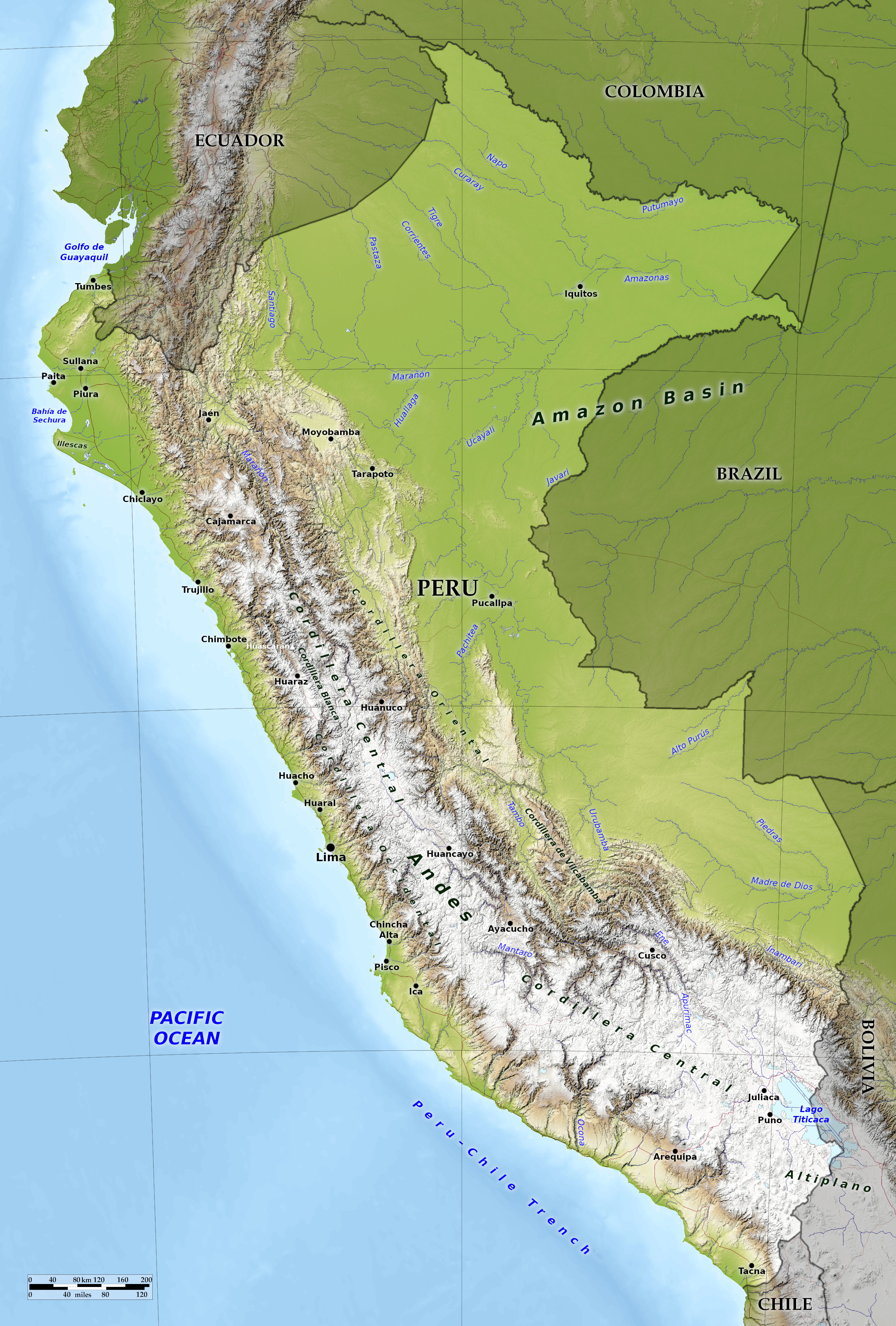
 Relief map of Peru
What is the landscape of Peru like?
Peru is the third largest country in South America, its area is about twice that of Texas. Peru has the three major regions: (1) a narrow coastal plain with mountain valleys, (2) the lofty mountain belt of the Andes, 200 to 250 miles in width, and (3) an eastern region of dense tropical forest, which includes more than half of the land of the country.
The Coastal Plain
The Peruvian coast receives dry winds, and the result is that the coast of Peru is very dry and sandy. Despite the desert conditions, however, the temperature is rarely very high and there are frequent mists and clouds. The High Andes, though, receives abundant rainfall, especially in summer, and this water, increased by melting snows, gives rise to many rivers, which form ribbon-like oases across the desert belt, each forming a miniature Nile Valley.
The Andes
The Andes form a high mountain belt 200 to 250 miles in width and which occupy nearly 40 per cent of the area of the country. The western range contains peaks 5,500 to 6,100 meters (18,000–20,000 feet) high and is practically continuous from north to south through Peru. Between the western and the eastern range there is a high plateau, generally exceeding 3,650 meters (12,000 feet) in height and crossed by irregular ranges. In these mountains, the rainfall is sufficient for crops. The valley floors and gentler slopes are everywhere cultivated and small villages dot the extensive grasslands. Cattle, sheep, alpacas, and llamas are raised. The Inca ruins that are found in the mountains amaze the visitor.
On the whole the southern part of the plateau is fairly flat. The skies are generally clear, and in the rarefied atmosphere the night temperature usually falls below freezing-point, and the margins of Lake Titicaca are often frozen. As on the plateau of Quito, the days are hot by contrast, and the difference is striking.
The Interior Plains
The lower eastern slopes of the Andes and the Amazon lowlands form about half the area of Peru. Many of the higher slopes and valleys are grasslands, but the lower slopes, up to 1,500 or 1,800 meters (5,000–6,000 feet), are densely forested, the rainfall being actually greater than in the lowlands. Much of the interior lowlands in the east is part of the Amazon jungle area with its tropical rainforests. Because of its isolation and various environmental limitations, however, this is Peru's least-populated region. Several large tributaries of the Amazon flow through eastern Peru and provide water routes that are used by canoes, launches, and boats.
 Sun temple at Pisac
What is the nature of Peru like?
Varying with the climate, the flora of Peru is represented on the dry coast only by a few gray herbs and in the depressions by the Prosopis, a low scraggy tree. Many of the plants subsist on the sea fog which forms dew on the plants. The western slopes of the maritime range, exposed to fogs and occasional rains, have sufficient vegetation to give them a green aspect mixed with yellow flowers. These meadows help support a few small animals, as well as a variety of birds and insects.
The high plateaus among the mountains have a great variety of species. The western slopes support dryland scrub species in places and dense forest cover in others. Brush and mountain forest, a dense growth of trees smaller than those of the rain forest, extend up the eastern slope to an height of about 3,350 meters (11,000 feet). Above this altitude and extending to the lifeless mountain peaks, trees give way to various communities of shrubs and mountain grasslands called puna. These grassy plains and hills extend for hundreds of miles through Peru’s highlands. Ichu grass dominates this ecosystem. It grows in scattered tussocks (tufts) up to 1 meter (3 feet) high. The puna is home to domesticated llamas and alpacas and wild vicuñas. One of the most defining images of the Peruvian highlands is herds of these animals grazing on ichu grass.
In the eastern plains, the upland flora gives way to tropical rain forest, the world’s most diverse ecosystem. Abundant moisture and constantly high temperatures combine to create an environmental hothouse in which both plant and animal life thrive. In the rain forest, each tree can be host to literally millions of smaller plants—mosses, lichens, bromeliads, vines, and many other species. The rain forest habitat supports only a very few large animals. Monkeys, the tapir, leopards, and various rodents are the largest land animals. Insects and birds abound.
What is the climate of Peru like?
See our main article: The Climate of Peru
The chief influences on the climate of Peru are the trade winds and the great differences in altitude. Much of the country is more temperate than might be expected from its position in the tropics. The mean annual temperature of the coast provinces is 20°C (68°F). In the hottest months, January and February, the mean temperature is between 28° and 30°C (82° to 86°F). The dry heat is not oppressive; and after 11 a.m., sea air comes rushing in, all life is refreshed by the breeze, and often a little rain is scattered over the western mountains. In the evening, when the surface of the desert grows cool, the wind sets to sea again, bringing cool breezes from the mountains. The whole mountain region lying between 1,000 and 2,750 meters (3,000–9,000 feet) above the sea has a temperate climate. Thus in nearly half of Peru the climate is exceptional.
The other half of Peru lies in the upper Amazon basin—the world’s largest tropical lowland. Here, temperatures are extremely uniform, varying little from day to day or season to season. Iquitos, the largest city in eastern Peru, is located 3 degrees south of the equator. Its range in temperatures is typical of the region: Coolest to warmest monthly averages range only 2 degrees, from 25° to 27°C (78° to 81°F).
The trade winds coming from the east deluge the eastern mountains, and give a smaller supply of water to the central range. But very little water is left for the western range however, making the western slope of Peru very dry. Once in seven or eight years a marvelous change comes over the face of this desert. Sufficient rain comes over the mountains to bring life out of the parched surface; grass and flowering plants appear, attracting animals from the irrigated valleys to the new pasture, which withers again in a few weeks. Very little rain falls in Lima, and the city's water supply derives from wells and from rivers that flow from the Andes.
| Climate data for Lima (1961–1990) | |||||||||||||
|---|---|---|---|---|---|---|---|---|---|---|---|---|---|
| Month | Jan | Feb | Mar | Apr | May | Jun | Jul | Aug | Sep | Oct | Nov | Dec | Year |
| Average high °C (°F) | 26.1 (79.0) | 26.8 (80.2) | 26.3 (79.3) | 24.5 (76.1) | 22.0 (71.6) | 20.1 (68.2) | 19.1 (66.4) | 18.8 (65.8) | 19.1 (66.4) | 20.3 (68.5) | 22.1 (71.8) | 24.4 (75.9) | 22.5 (72.5) |
| Daily mean °C (°F) | 22.1 (71.8) | 22.7 (72.9) | 22.2 (72.0) | 20.6 (69.1) | 18.8 (65.8) | 17.5 (63.5) | 16.7 (62.1) | 16.2 (61.2) | 16.4 (61.5) | 17.3 (63.1) | 18.7 (65.7) | 20.7 (69.3) | 19.2 (66.6) |
| Average low °C (°F) | 19.4 (66.9) | 19.8 (67.6) | 19.5 (67.1) | 17.9 (64.2) | 16.4 (61.5) | 15.6 (60.1) | 15.2 (59.4) | 14.9 (58.8) | 14.9 (58.8) | 15.5 (59.9) | 16.6 (61.9) | 18.2 (64.8) | 17.2 (63.0) |
| Average precipitation mm (inches) | 0.8 (0.03) | 0.4 (0.02) | 0.4 (0.02) | 0.1 (0.00) | 0.3 (0.01) | 0.7 (0.03) | 1.0 (0.04) | 1.5 (0.06) | 0.7 (0.03) | 0.2 (0.01) | 0.1 (0.00) | 0.2 (0.01) | 6.4 (0.25) |
| Source: Deutscher Wetterdienst | |||||||||||||
 Uros islands on Lake Titicaca
The official websites
Peru

Land of the Incas
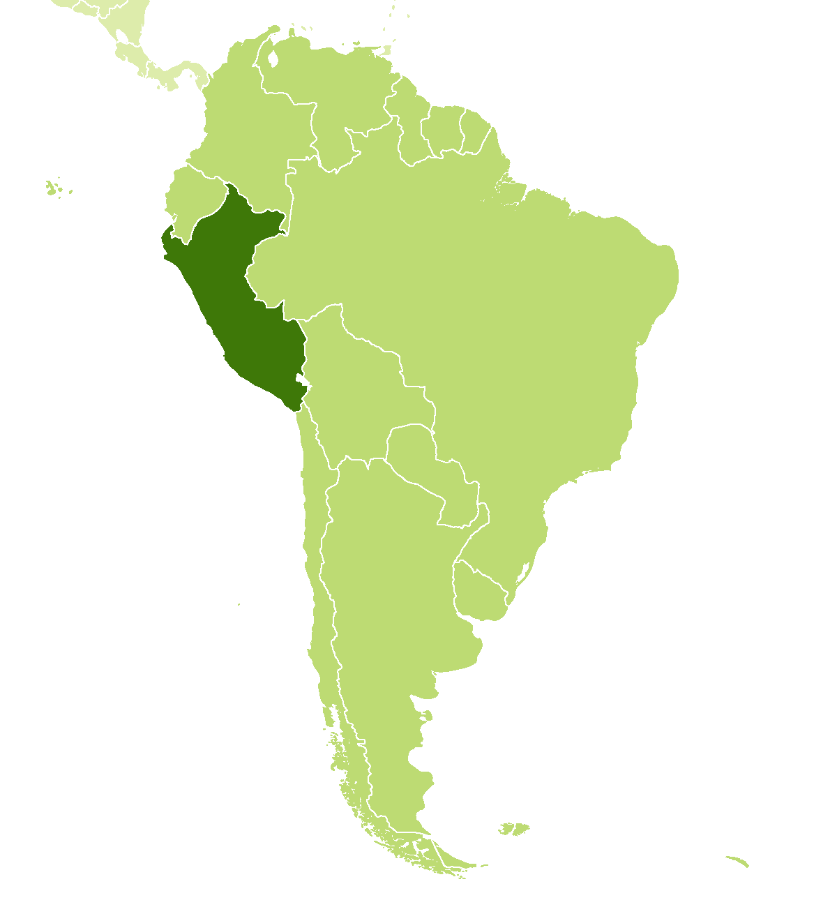
| Location: | Western South America, bordering the Pacific Ocean, between Chile and Ecuador |
| Coordinates: | 10° 00′ S, 76° 00′ W |
| Size: | • 2080 km N-S; 1380 km E-W • 1290 miles N-S; 860 miles E-W |
| Terrain: | An arid coastal plain; high plateau of the Andes; eastern lowland rainforests |
| Climate: | Varies from tropical in east to dry desert in west; temperate to cold in Andes |
| Highest point: | Huascarán 6,768 m / 22,205 ft |
| Forest: | 58% (2015 est.) (source) |
| Population: | 32,275,736 (2022 est.) |
| Population density: | Low (23/km²) |
| Capital: | Lima |
| Languages: | Spanish (official) 82.9%; Quechua (official) 13.6%; Aymara (official) 1.6%; Other native languages |
| Human Development Index: | High (0.777) |
| Currency: | Peruvian sol |


