The Geography of
Valencia
Why visit Valencia?
Valencia is a series of tablelands which descends from the eastern boundary of Castilla-La Mancha. Here figs, almonds, olives or vines are grown. The coast is skirted by considerable stretches of sand-dune. The lowlands have an exceptionally fine, almost sub-tropical climate, with low rainfall.
Contents
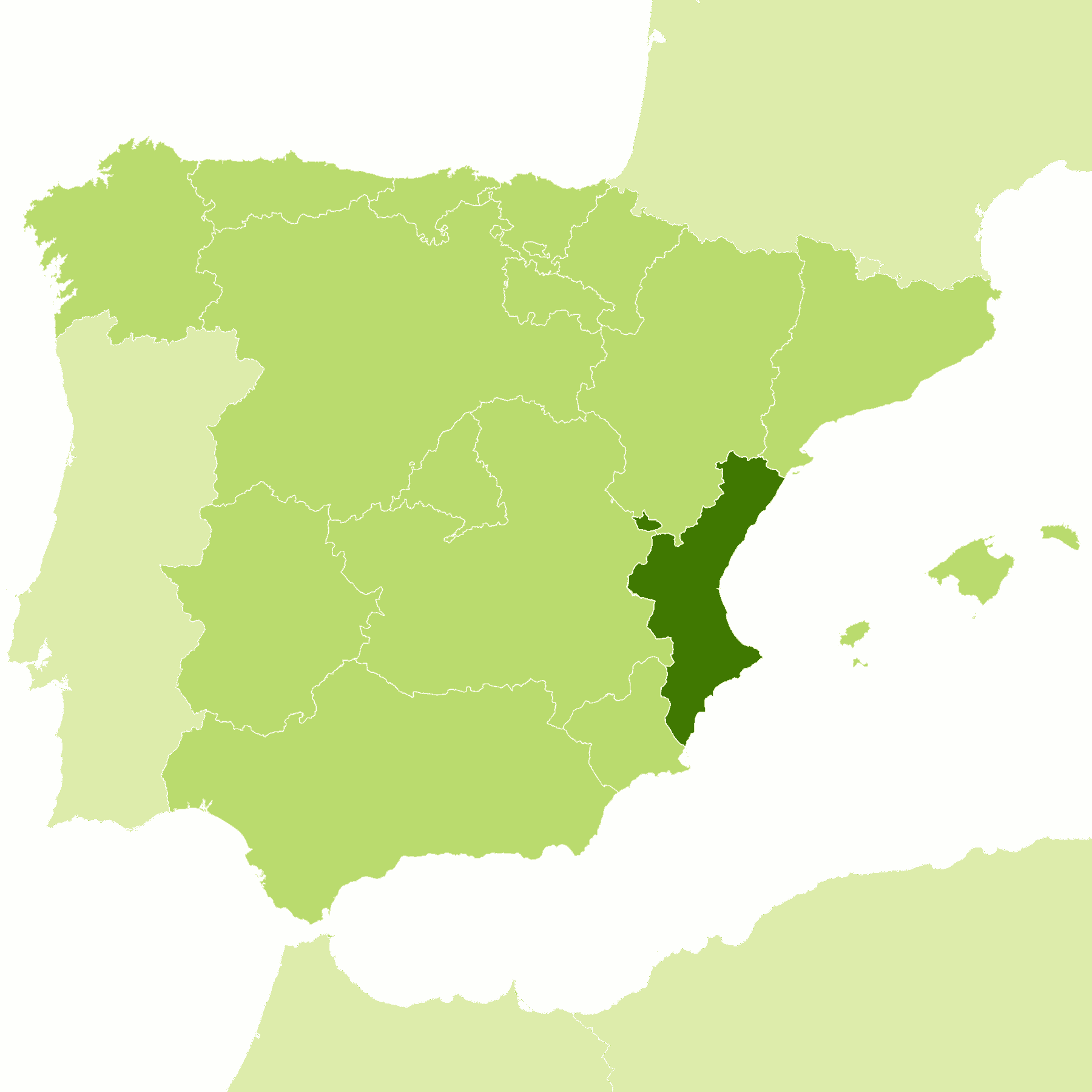
Map
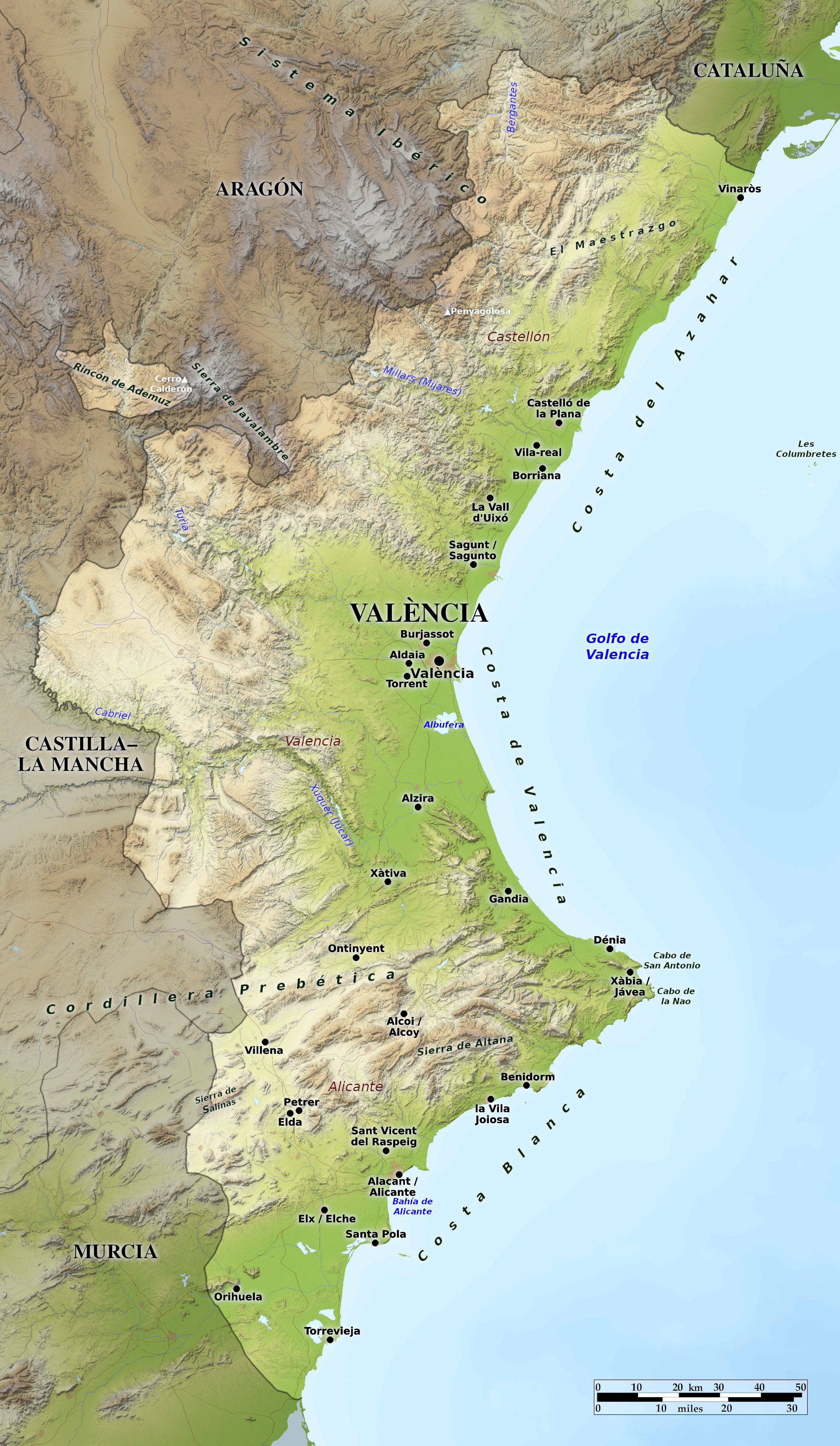
 Relief map of Valencia
What is the landscape of Valencia like?
The Valencian Community is a region of Spain consisting of the three provices of Castellón, Valencia, and Alicante. It is one of the most popular stretches of Spain's Mediterranean coast. The climate across much of the region is subtropical, and citrus fruits, especially oranges, are a major crop. The shores of Valencia are dotted with miles of wide beaches and accompanying resorts (especially around the Costa Blanca), which cater to the millions of sun-seekers each year.
Elsewhere the coast is skirted by considerable stretches of sand-dune alternating with cliffs, and in some places there are wetlands and lagoons such as the freshwater Albufera lagoon south of the city of Valencia. But the coast is only one part of the wider Valencia region. In fact mountains occupy most of the region, and in many places they are only a short distance from the coastline. These mountains are a series of tablelands which rise in turn to the mountains that border the plateau of central Spain.
What is the nature of Valencia like?
The typical vegetation of the Valencian Community is Mediterranean forest with trees adapted to summer drought. The most abundant tree species is the Aleppo pine followed by the evergreen oak (Quercus ilex). Other oak species (holm oak, gall oaks, and cork oaks) are common, as well as olive, almond, carob, orange and persimmon trees as cultivated species. The dominant undergrowth is composed of thorny and aromatic woody species, such as rosemary, thyme, kermes oak, mastic, myrtle, fennel, gorse and rockrose. Riverbeds and wetlands have their own vegetation, consisting of trees such as poplars, and shrubs such as reeds, grasses and sedges.
What is the climate of Valencia like?
As might be expected, the climate of the Valencian Community is a Mediterranean one, becoming somewhat continental inland. The coasts have long, dry and hot summers, almost sub-tropical, with rain in autumn and spring, and mild winters with only occasional cold spells. The climate in the mountain regions is influenced by altitude—both summer and winter are cooler, and rainfall more abundant and sometimes arrives in the form of snow during the winter.
| Climate data for Valencia (1981–2010) | |||||||||||||
|---|---|---|---|---|---|---|---|---|---|---|---|---|---|
| Month | Jan | Feb | Mar | Apr | May | Jun | Jul | Aug | Sep | Oct | Nov | Dec | Year |
| Average high °C (°F) | 16.4 (61.5) | 17.1 (62.8) | 19.3 (66.7) | 20.8 (69.4) | 23.4 (74.1) | 27.1 (80.8) | 29.7 (85.5) | 30.2 (86.4) | 27.9 (82.2) | 24.3 (75.7) | 19.8 (67.6) | 17.0 (62.6) | 22.8 (73.0) |
| Daily mean °C (°F) | 11.9 (53.4) | 12.7 (54.9) | 14.6 (58.3) | 16.2 (61.2) | 19.0 (66.2) | 22.9 (73.2) | 25.6 (78.1) | 26.1 (79.0) | 23.5 (74.3) | 19.7 (67.5) | 15.3 (59.5) | 12.6 (54.7) | 18.3 (64.9) |
| Average low °C (°F) | 7.1 (44.8) | 7.8 (46.0) | 9.7 (49.5) | 11.5 (52.7) | 14.6 (58.3) | 18.6 (65.5) | 21.5 (70.7) | 21.9 (71.4) | 19.1 (66.4) | 15.2 (59.4) | 10.8 (51.4) | 8.1 (46.6) | 13.8 (56.8) |
| Average precipitation mm (inches) | 37 (1.5) | 36 (1.4) | 33 (1.3) | 38 (1.5) | 39 (1.5) | 22 (0.9) | 8 (0.3) | 20 (0.8) | 70 (2.8) | 77 (3.0) | 47 (1.9) | 48 (1.9) | 475 (18.7) |
| Source: Agencia Estatal de Meteorología | |||||||||||||
The official websites
Comunidad Valenciana

Mediterranean Live
| Location: | Eastern Spain |
| Coordinates: | 39° 30′ N, 0° 45′ W |
| Size: | • 330 km N-S; 175 km E-W • 205 miles N-S; 110 miles E-W |
| Terrain: | Low and level coast rising to a series of tablelands and hill ranges inland and to mountains on the western border |
| Climate: | Hot, dry summers and mild winters along the coast; cooler in the mountains with a little winter snow |
| Highest point: | Cerro Calderón 1838 m / 6030 ft |
| Forest: | 17% (2010 est.) (source) |
| Population: | 5,057,353 (2020) |
| Population density: | High (217/km²) |
| Capital: | Valencia |
| Languages: | Valencian; Spanish |
| Human Development Index: | Very High (0.894) |
.jpg)


