The Geography of
Aragón
Why visit Aragon?
The north of Aragon is where the Pyrenees reach their greatest height, whereas the mountains in the south are wild and rugged. There are plains of considerable beauty around the larger towns, and the climate is very hot in summer.
Contents
Map
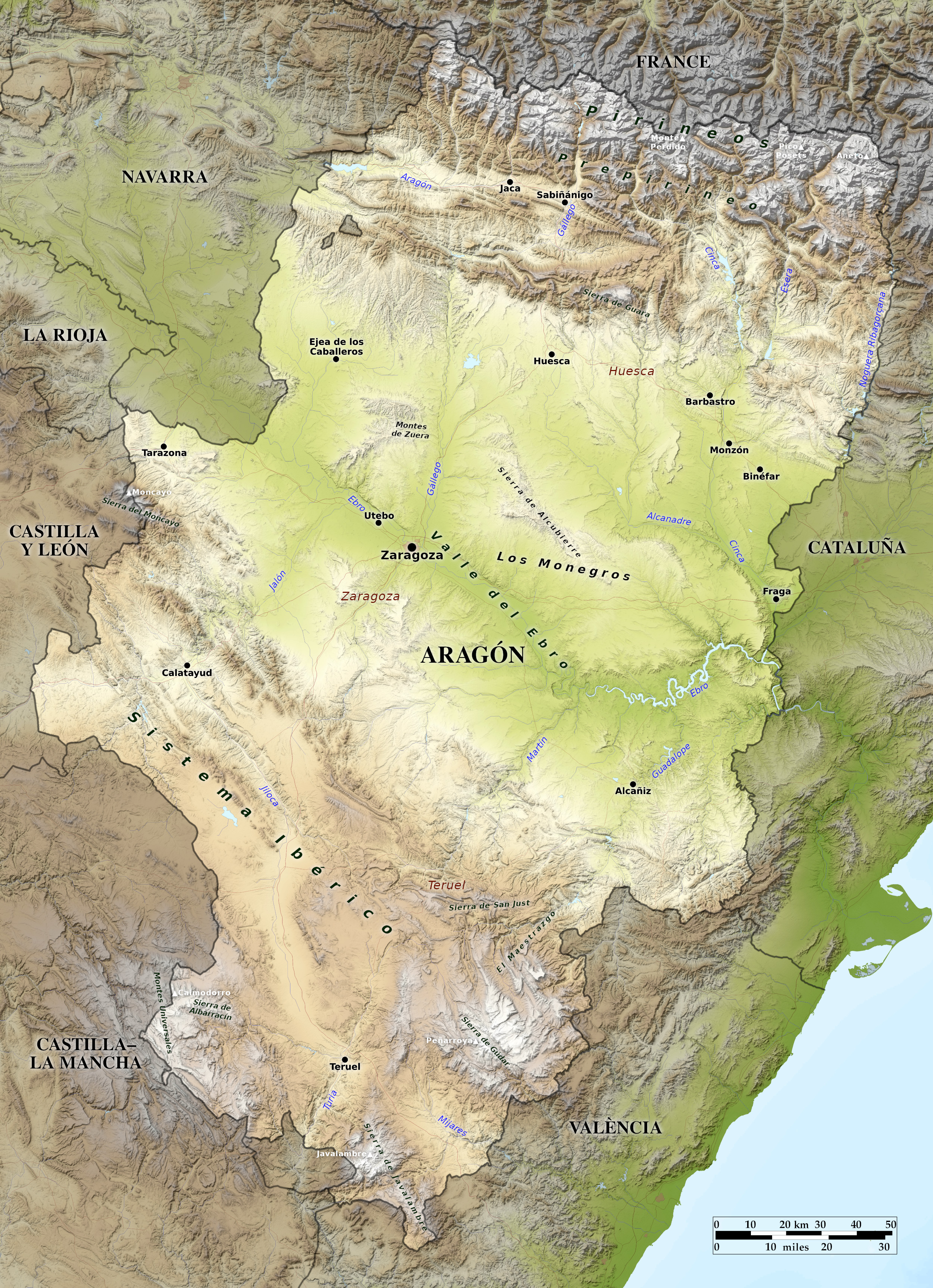
 Relief map of Aragón
What is the landscape of Aragon like?
Long an independent kingdom, Aragon's most famous son was King Ferdinand, who, by marrying Isabella of Castile in 1479, set Spain on the course to world empire. Aragon consists of a central plain, surrounded by mountain ranges. The ranges on the south, east and west, are wild and rugged, but on the north the Pyrenees attain their greatest altitude in the peak of Aneto (3,404 m / 11,168 feet). The Pyrenees and are wooded and well watered, representing a mecca for skiers, hikers, and other outdoor enthusiasts. Aragon is divided by the river Ebro, which flows through it in a southeasterly direction.
The largest city in Aragon is Zaragoza—the city features many monuments that may be traced to both its Islamic and its Christian masters. Huesca in the north was established over two-thousand years ago, and the city offers some spectacular architecture. Aragon's principle city in the south is Teruel, a small city located in the heart of arid plains and grassy hills. The province that surrounds Teruel may be characterized as "forgotten Spain"—a wilderness, stony, ash-coloured, with dry watercourses, and a landscape of grass and heaths.
What is the nature of Aragon like?
Away from the Pyrenees, the landscape, like the rest of central Spain, seems almost a continuation of the north African deserts. There are, however, extensive oak, pine and beech forests in the highlands, and many beautiful oases in the deeply sunk valleys, and along the rivers, especially beside the Ebro, which has been called the "Nile of Aragon." In such oases the plantlife is very rich.
What is the climate of Aragon like?
The climate of Aragon is characterized by extreme heat in the summer and cold in the winter; among the mountains the snowfall is heavy, and thunderstorms are frequent, but there is comparatively little rain.
| Climate data for Zaragoza (1981-2010) | |||||||||||||
|---|---|---|---|---|---|---|---|---|---|---|---|---|---|
| Month | Jan | Feb | Mar | Apr | May | Jun | Jul | Aug | Sep | Oct | Nov | Dec | Year |
| Average high °C (°F) | 10.5 (50.9) | 13.1 (55.6) | 17.3 (63.1) | 19.6 (67.3) | 24.1 (75.4) | 29.3 (84.7) | 32.4 (90.3) | 31.7 (89.1) | 27.1 (80.8) | 21.4 (70.5) | 14.8 (58.6) | 10.8 (51.4) | 21.0 (69.8) |
| Daily mean °C (°F) | 6.6 (43.9) | 8.2 (46.8) | 11.6 (52.9) | 13.8 (56.8) | 18.0 (64.4) | 22.6 (72.7) | 25.3 (77.5) | 25.0 (77.0) | 21.2 (70.2) | 16.2 (61.2) | 10.6 (51.1) | 7.0 (44.6) | 15.5 (59.9) |
| Average low °C (°F) | 2.7 (36.9) | 3.3 (37.9) | 5.8 (42.4) | 7.9 (46.2) | 11.8 (53.2) | 15.8 (60.4) | 18.3 (64.9) | 18.3 (64.9) | 15.2 (59.4) | 11.0 (51.8) | 6.3 (43.3) | 3.2 (37.8) | 10.0 (49.9) |
| Average precipitation mm (inches) | 21.0 (0.83) | 21.5 (0.85) | 19.1 (0.75) | 39.3 (1.55) | 43.7 (1.72) | 26.4 (1.04) | 17.3 (0.68) | 16.6 (0.65) | 29.5 (1.16) | 36.4 (1.43) | 29.8 (1.17) | 21.4 (0.84) | 322 (12.67) |
| Source: Agencia Estatal de Meteorología | |||||||||||||
Church of San Pedro Apóstol, Fuentes Claras, Teruel
The official websites
Aragón

A place for nature and adventure
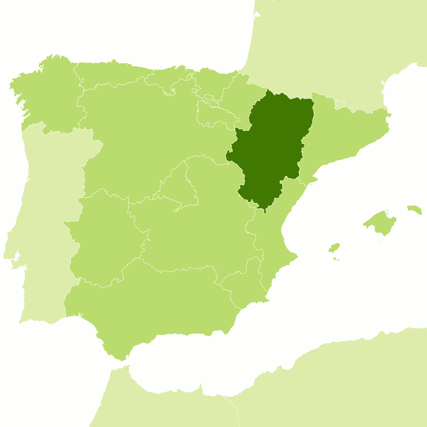
| Location: | Northeast Spain |
| Coordinates: | 41° 15′ N, 0° 45′ W |
| Size: | • 340 km N-S; 245 km E-W • 210 miles N-S; 150 miles E-W |
| Terrain: | Central plain edged by mountain ranges. Lower mountains to the south, east and west; higher Pyrenees to the north |
| Climate: | Hot summers; cold winters. Comparatively little rain. Winter snowfall in the mountains |
| Highest point: | Aneto 3,404 m / 11,168 ft |
| Forest: | 16% (2010 est.) (source) |
| Population: | 1,329,391 (2020) |
| Population density: | Low (28/km²) |
| Capital: | Zaragoza |
| Languages: | Spanish; Aragonese; Catalan |
| Human Development Index: | Very High (0.911) |
.jpg)


