.jpg)
.jpg)
.jpg)
.jpg)
.jpg)
The Geography of
Nevada
Why visit Nevada?
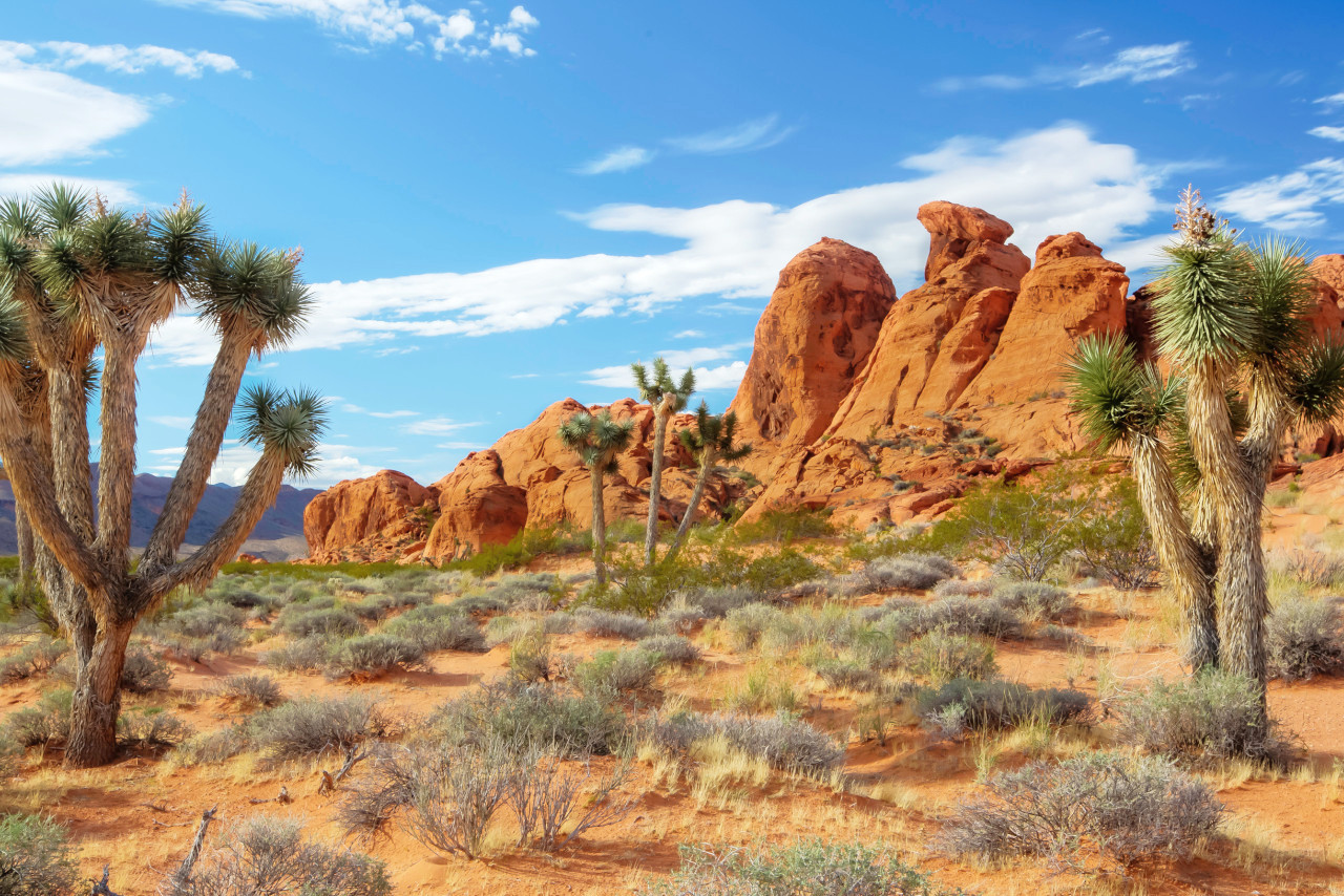
Spending time in Nevada is like escaping to another world. It’s known for its vast open spaces, deserts, and mountains. The mountains create a beautiful backdrop for the desert landscape, which is incredibly beautiful, with many different colors and shapes. There are many places to visit in Nevada, which are unique and interesting, including the Great Basin National Park, and Lake Mead and Pyramid Lake. The scenery is always enchanting.
Contents
Map
 Relief map of Nevada
What is the landscape of Nevada like?
.jpg)
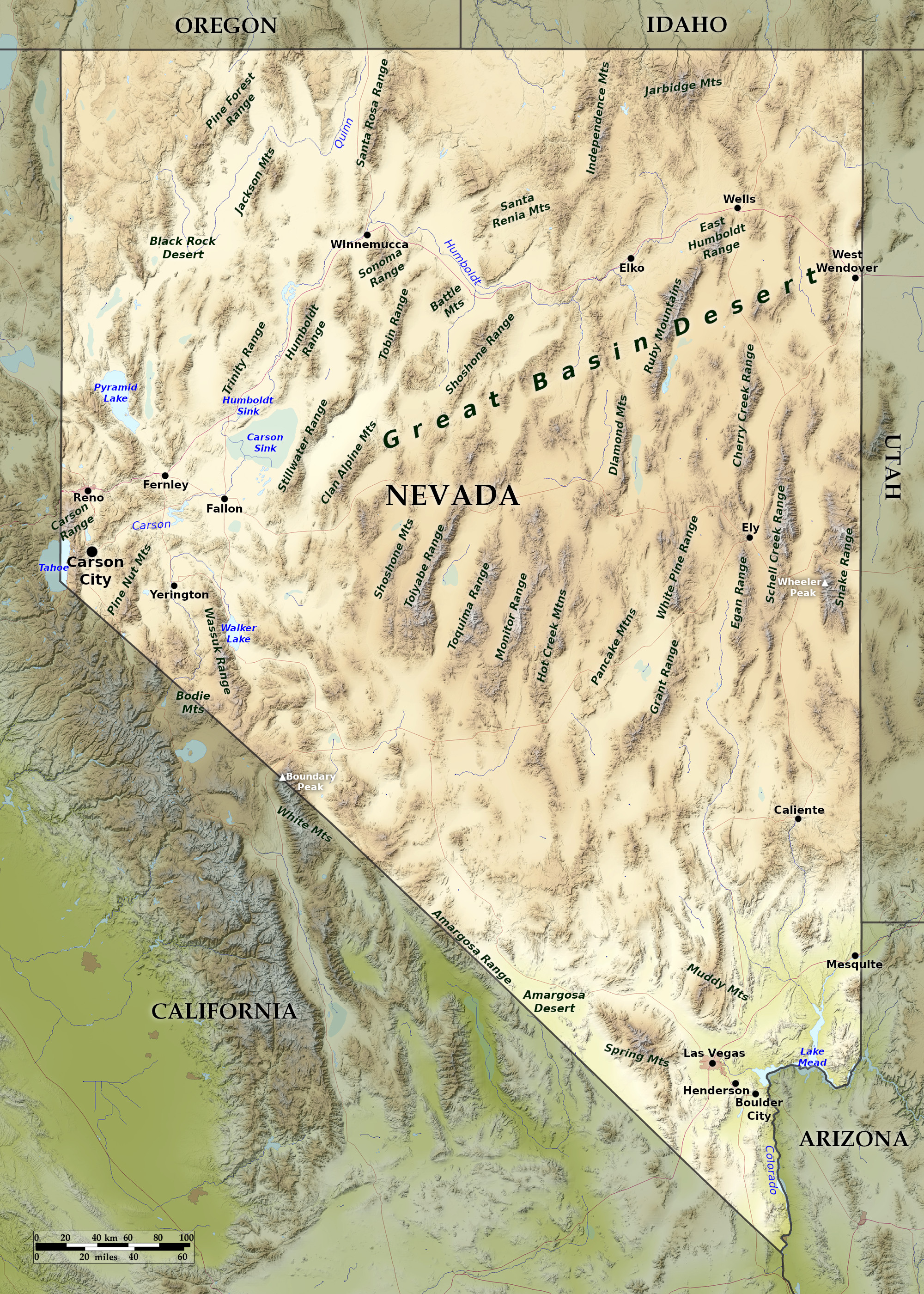
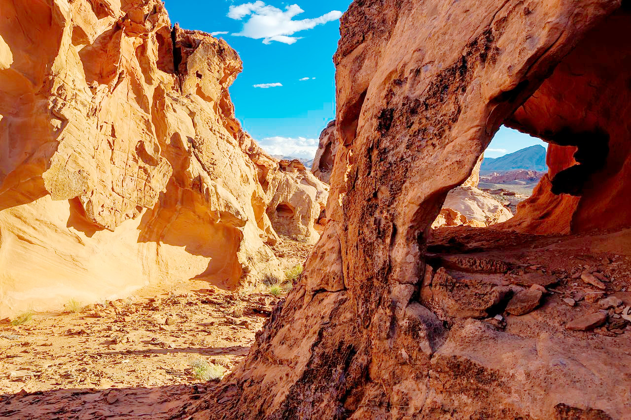
Nevada is a land of isolated mountain ranges and mesas. The northeast is defined by very broken and ill-defined mountain ranges, with peaks often reaching altitudes of from 9000 to 12,000 feet (2700–3650 m). The remainder of the State is very rugged, and frequently broken by mountain ranges running north and south and from 5 to 20 miles wide at their bases. Intersecting the mountains are countless ravines and passes. Between the ranges lie valleys of about the same width as the bases of the mountains.
The Sierra Nevada range of California overlooks the western borders of the state. The highest point within the state though is Wheeler Peak, near the the eastern border, with a height of 13,065 feet (3,982 m); the lowest points are along the Colorado river in the southeast, where the altitudes range from 700 to 800 feet (210–240 m). With the exception of this dip in the southeast corner, the entire State lies above 2000 feet (600 m). Many of the mountains of Nevada are steep and rugged, with mountain rivers which soon disappear within beds of narrow canyons.
.jpg)
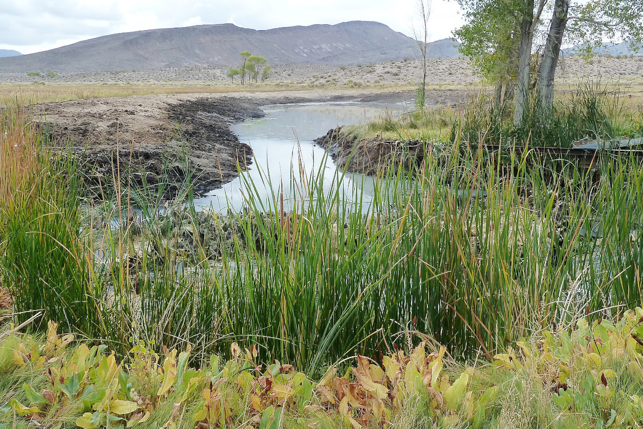
Many of the lakes of Nevada are ephemeral—usually evaporating in the course of the summer. These are formed by waters that fall on the barren mountain-sides and rush down in torrents forming in the valleys shallow bodies of water yellow with mud. When the waters evaporate in the summer they leave a clay bed of remarkable hardness, which is sometimes encrusted with salt material of a snowy whiteness and dazzles the eyes of the traveller.
What is the nature of Nevada like?
.jpg)
.jpg&oldid=564550146)
.jpg&oldid=576320436)
.jpg&oldid=492675926)
.jpg&oldid=609025507)
.jpg&oldid=562863067)
.jpg&oldid=688085283)
.jpg&oldid=698842583)
.jpg&oldid=698842708)
Although plantlife is scanty in Nevada, few parts of the desert are devoid of vegetation even in the driest seasons. In the far southwest, close to the Sierra Nevada mountains, there is a heavy growth of conifers extending down to the valleys. In limited spaces on other mountains there are scattered trees such as the single-leaf pinyon (a nut pine) and the juniper. Several varieties of poplar are found in the upper canyons, and trees of the willow-leaved species in the Humboldt Mountains. But except for these infrequent wooded strips, the mountains are even more bare than the valleys, and their shrubs are dwarfed from exposure.
On the foothills are found flowering plants such as the phlox and lupine, and in the north, bunch grass. The valleys are covered with typical desert shrubs: greasewood, creosote bushes, and sagebrush. This vegetation, covering plains, mesas, and even extending up the sides of the mountains, gives the entire landscape a grey or olive color. To the south, as the valleys become increasingly sandy and salty, even the sagebrush disappears, and the cactus and the yucca are to be seen. Mesquite trees grow some distance from water, and are common near the Colorado river.
What is the climate of Nevada like?
Nevada is excessively dry. The Sierra Nevada mountains deprive the winds from the Pacific of nearly all their moisture before they reach the State. A so-called "rainy season" lasts from October to April, but the rainfall is chiefly in the form of snow on the mountains. The melting of the mountain snowcaps in the spring causes torrents of water, which in turn are followed by long seasons of drought.
The skies are clear nearly every day in the year; any rain comes sporadically, and cloudbursts are not unknown. In spite of the high temperatures of summer, the low humidity means the heat isn't always oppressive. In the summer and autumn the winds are light, but they are stronger in winter and spring.
| Climate data for Carson City, Nevada (1981–2010) | |||||||||||||
|---|---|---|---|---|---|---|---|---|---|---|---|---|---|
| Month | Jan | Feb | Mar | Apr | May | Jun | Jul | Aug | Sep | Oct | Nov | Dec | Year |
| Average high °F (°C) | 45.2 (7.3) | 49.9 (9.9) | 56.7 (13.7) | 62.7 (17.1) | 71.4 (21.9) | 81.1 (27.3) | 89.6 (32.0) | 88.0 (31.1) | 80.4 (26.9) | 67.9 (19.9) | 54.4 (12.4) | 45.0 (7.2) | 66.0 (18.9) |
| Daily mean °F (°C) | 33.5 (0.8) | 37.6 (3.1) | 43.3 (6.3) | 48.3 (9.1) | 56.1 (13.4) | 64.1 (17.8) | 70.9 (21.6) | 69.3 (20.7) | 61.9 (16.6) | 51.2 (10.7) | 40.7 (4.8) | 33.4 (0.8) | 50.9 (10.5) |
| Average low °F (°C) | 21.7 (−5.7) | 25.3 (−3.7) | 29.9 (−1.2) | 33.9 (1.1) | 40.8 (4.9) | 47.1 (8.4) | 52.2 (11.2) | 50.6 (10.3) | 43.4 (6.3) | 34.6 (1.4) | 27.1 (−2.7) | 21.9 (−5.6) | 35.7 (2.1) |
| Average precipitation inches (mm) | 1.59 (40) | 1.50 (38) | 1.15 (29) | 0.43 (11) | 0.43 (11) | 0.40 (10) | 0.19 (4.8) | 0.21 (5.3) | 0.39 (9.9) | 0.77 (20) | 1.19 (30) | 1.43 (36) | 9.66 (245) |
| Source: NOAA | |||||||||||||
| Climate data for Las Vegas, Nevada (1991–2020) | |||||||||||||
|---|---|---|---|---|---|---|---|---|---|---|---|---|---|
| Month | Jan | Feb | Mar | Apr | May | Jun | Jul | Aug | Sep | Oct | Nov | Dec | Year |
| Average high °F (°C) | 58.5 (14.7) | 62.9 (17.2) | 71.1 (21.7) | 78.5 (25.8) | 88.5 (31.4) | 99.4 (37.4) | 104.5 (40.3) | 102.8 (39.3) | 94.9 (34.9) | 81.2 (27.3) | 67.1 (19.5) | 56.9 (13.8) | 80.5 (26.9) |
| Daily mean °F (°C) | 49.5 (9.7) | 53.5 (11.9) | 60.8 (16.0) | 67.7 (19.8) | 77.3 (25.2) | 87.6 (30.9) | 93.2 (34.0) | 91.7 (33.2) | 83.6 (28.7) | 70.4 (21.3) | 57.2 (14.0) | 48.2 (9.0) | 70.1 (21.2) |
| Average low °F (°C) | 40.5 (4.7) | 44.1 (6.7) | 50.5 (10.3) | 56.9 (13.8) | 66.1 (18.9) | 75.8 (24.3) | 82.0 (27.8) | 80.6 (27.0) | 72.4 (22.4) | 59.6 (15.3) | 47.3 (8.5) | 39.6 (4.2) | 59.6 (15.3) |
| Average precipitation inches (mm) | 0.56 (14) | 0.80 (20) | 0.42 (11) | 0.20 (5.1) | 0.07 (1.8) | 0.04 (1.0) | 0.38 (9.7) | 0.32 (8.1) | 0.32 (8.1) | 0.32 (8.1) | 0.30 (7.6) | 0.45 (11) | 4.18 (106) |
| Source: NOAA | |||||||||||||
 Gold Butte National Monument
The official websites
Nevada
The Silver State
| Location: | Southwestern United States |
| Coordinates: | 39° 15′ N, 116° 45′ W |
| Size: | • 775 km N-S; 515 km E-W • 485 miles N-S; 320 miles E-W |
| Terrain: | Isolated mountain ranges separated by arid basins |
| Climate: | Continental climate. Hot summers; cold winters; very dry. Snowfall in the mountains. |
| Highest point: | Boundary Peak 4,007 m / 13,147 ft |
| Forest: | 16% (2016) (source) |
| Population: | 3,080,156 (2019) |
| Population density: | Low (10/km²) |
| Capital: | Carson City |
| Languages: | English; Spanish |
| Human Development Index: | Very High (0.909) |