.jpg)
.jpg)
The Geography of
South Dakota
Why visit South Dakota?
South Dakota is a wonderful place to relax. The landscape features rolling hills, prairies, and woodlands. The Black Hills are a beautiful, forested area that is very popular with the locals. The prairies are also beautiful—the Great Plains are a vast, open area that is very attractive. And then there's Badlands National Park where erosion has created a landscape of sharply eroded buttes and pinnacles.
Contents
Map
 Relief map of South Dakota
What is the landscape of South Dakota like?
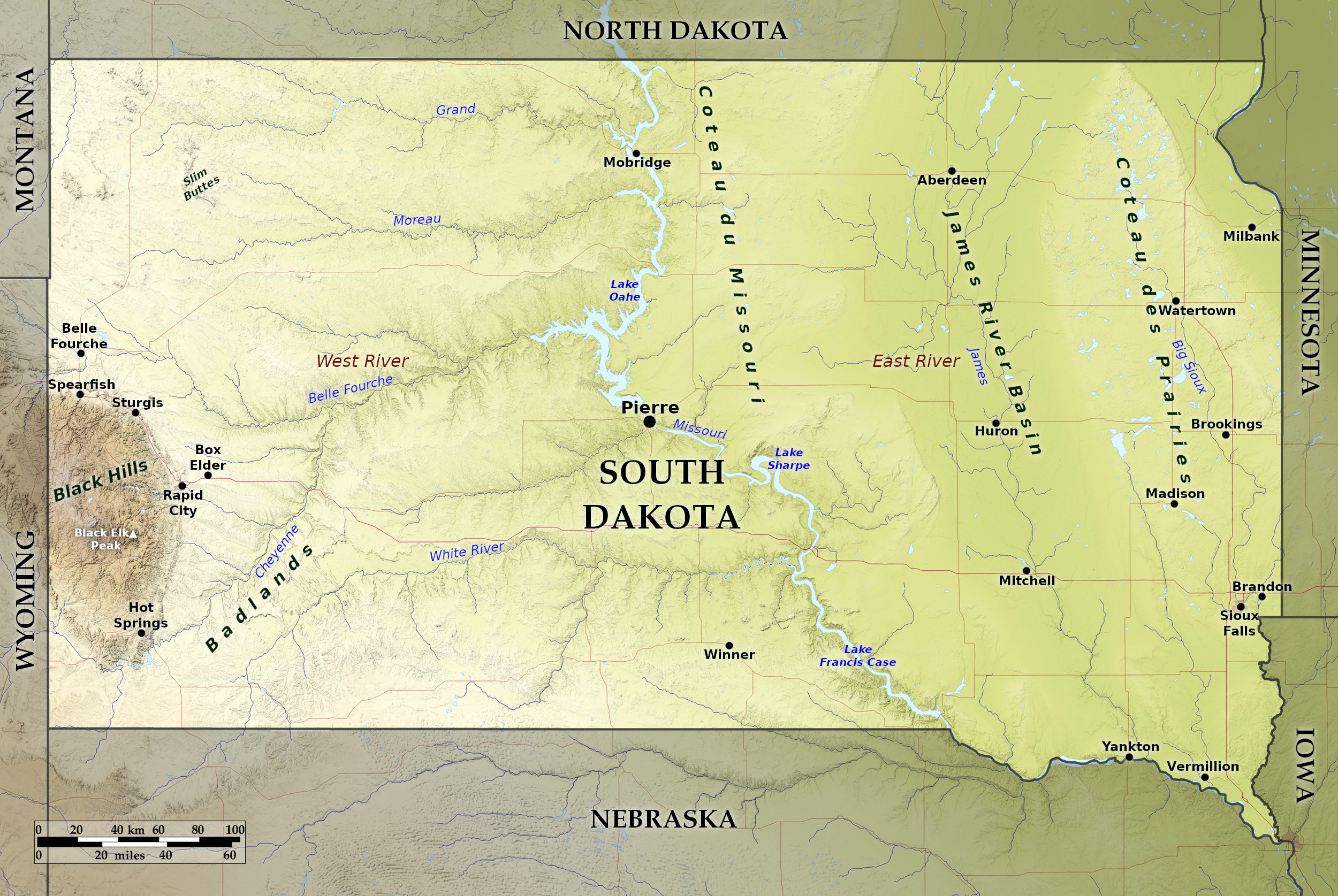
With the exception of the Black Hills district in the south-west, South Dakota is a wide rolling plain, with its eastern portion a part of the Prairie Plains region, and its western portion a part of the Great Plains. The surface of this plain, however, ranges from level river valleys in the east to irregular plateaus broken by buttes and scored by canyons in the west.
East—the Prairie Plains
In the extreme north-east there is a range of low hills known as the Coteau des Prairies, which crosses the state in a south-southeast direction and maintains an almost constant altitude of from 1,950 to 2,050 feet (600 m). To the south and west of the Coteau des Prairies lie vast stretches of plains, including the broad valley of the James river. This entire region is dotted with numerous lakes, ranging from small ponds to bodies of water from 10 to 15 miles in diameter. West of the James River Valley lies an elevated tableland, known as the Coteau du Missouri, which has a general height of about 1,800 feet (550 m), and where the surface has a gently undulating appearance. And then we encounter the Missouri river which enters the state from the north, and pursues a winding southeasterly course.
West—the Great Plains
.jpg)
.jpg&oldid=501414579)
.jpg&oldid=499106155)
.jpg&oldid=649415107)
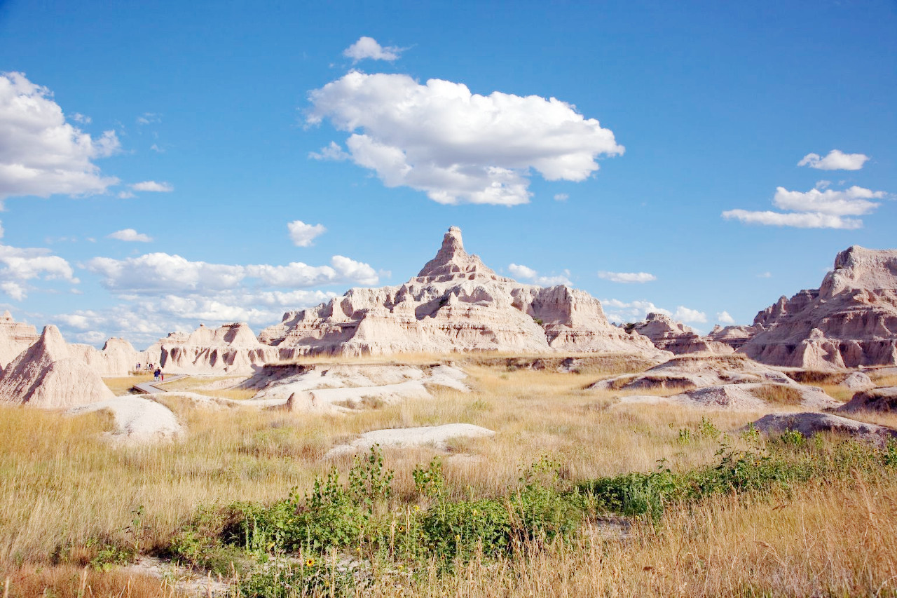
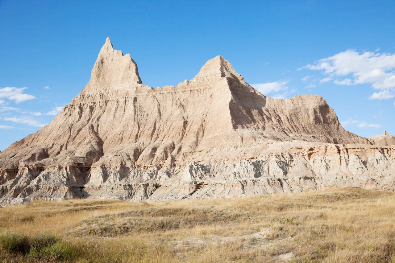
West of the Missouri river are the Great Plains which steadily rise to a height of around 3,500 feet (1,000 m) on the western border. Here the landscape is broken by many clusters of small hills, and in the vicinity of rivers it is much cut up by deep ravines. In the southwest the results of this erosion are seen in an accentuated form in the region known as the Bad Lands or 'terres mauvaises'. Here the land becomes a labyrinth of ravines and ridges, and the land surface has been carved into forms in infinite variety. Many slender columns of clay, supporting masses of sandstone which have protected them from erosion, rise from the surface like gigantic toadstools. The sides of these ridges and pinnacles are bare of vegetation and display a variety of colours in buff, cream, pale green, grey and flesh. The most prominent features of the landscape rise from 150 to 300 feet (45–90 m) above the valleys. The Badlands of the White river are also noted for their wealth of animal fossils.
The Black Hills
West of the Bad Lands lie the Black Hills, an irregular dome-shaped mountain mass, about 125 miles long and 60 miles wide, and lying partly in Wyoming. It is enclosed by a rim of hog-back ridges from 300 to 600 feet (90–180 m) above the plain. The central area wide valleys and "parks", but the rivers flowing from the central area have cut deep gorges and canyons, and among the ridges the rocks have assumed many strange forms. Though rising from a semi-arid plateau, these mountains have sufficient rainfall to support an abundant plant growth, and have derived their name from the fact that their slopes are dark with heavy forests.
What is the nature of South Dakota like?
South Dakota as a whole is a treeless prairie. Forests are found in the Black Hills above an altitude of 4,000 feet (1,200 m), where there is a good growth of pine. But strips of deciduous forest follow all the rivers in the east and thin out westwardly until only scattered deciduous trees follow stream courses. Tall grasses occupy the eastern part of the State among which are blue stems, Indian grass, and spear or needle grass. Many other plants bearing beautiful flowers are abundant. The dry plains of the western part of the state are covered by a short grass in which grama grass and buffalo grass are dominant.
What is the climate of South Dakota like?
South Dakota has a continental climate with great annual variations of temperature but only a small amount of rainfall. The State is coldest in the northeast and warmest in the southwest. The winters are long with low temperatures, but they are also driest season of the year. Likewise the heat of summer is endurable owing to the dryness of the atmosphere which renders the climate pleasant.
| Climate data for Pierre, South Dakota (1991−2010) | |||||||||||||
|---|---|---|---|---|---|---|---|---|---|---|---|---|---|
| Month | Jan | Feb | Mar | Apr | May | Jun | Jul | Aug | Sep | Oct | Nov | Dec | Year |
| Average high °F (°C) | 29.0 (−1.7) | 33.7 (0.9) | 45.7 (7.6) | 58.5 (14.7) | 69.5 (20.8) | 80.0 (26.7) | 88.3 (31.3) | 86.6 (30.3) | 77.5 (25.3) | 60.7 (15.9) | 44.9 (7.2) | 32.4 (0.2) | 58.9 (14.9) |
| Daily mean °F (°C) | 19.1 (−7.2) | 23.2 (−4.9) | 34.3 (1.3) | 45.9 (7.7) | 57.2 (14.0) | 67.8 (19.9) | 74.9 (23.8) | 73.0 (22.8) | 63.6 (17.6) | 48.5 (9.2) | 34.1 (1.2) | 22.8 (−5.1) | 47.0 (8.3) |
| Average low °F (°C) | 9.3 (−12.6) | 12.6 (−10.8) | 22.9 (−5.1) | 33.3 (0.7) | 44.9 (7.2) | 55.6 (13.1) | 61.6 (16.4) | 59.4 (15.2) | 49.7 (9.8) | 36.2 (2.3) | 23.2 (−4.9) | 13.2 (−10.4) | 35.2 (1.8) |
| Average precipitation inches (mm) | 0.45 (11) | 0.74 (19) | 0.96 (24) | 1.93 (49) | 3.25 (83) | 3.69 (94) | 2.39 (61) | 1.95 (50) | 1.74 (44) | 1.69 (43) | 0.77 (20) | 0.64 (16) | 20.20 (513) |
| Average snowfall inches (cm) | 5.1 (13) | 8.0 (20) | 5.0 (13) | 5.3 (13) | 0.0 (0.0) | 0.0 (0.0) | 0.0 (0.0) | 0.0 (0.0) | 0.0 (0.0) | 1.3 (3.3) | 6.3 (16) | 6.2 (16) | 37.2 (94) |
| Source: NOAA | |||||||||||||
.jpg) Mixed grass prairie, Sand Lake Wetland Management District
Mixed grass prairie, Sand Lake Wetland Management District
.jpg&oldid=506798040)
The official websites
South Dakota
The Coyote State
| Location: | North-central United States |
| Coordinates: | 44° 30′ N, 100° 15′ W |
| Size: | • 395 km N-S; 610 km E-W • 245 miles N-S; 380 miles E-W |
| Terrain: | The east is lowland prairie; the west is part of the Great Plains plateau; The Black Hills occupy the southwest |
| Climate: | Continental climate, with hot summers and cold winters. Dry with some droughts especially towards the northwest. Winter snow |
| Highest point: | Black Elk Peak 2,208 m / 7,244 ft |
| Forest: | 4% (2016) (source) |
| Population: | 886,667 (2020) |
| Population density: | Very Low (4/km²) |
| Capital: | Pierre |
| Languages: | English |
| Human Development Index: | Very High (0.932) |