.jpeg)
.jpeg)
.jpeg)
.jpeg)
.jpeg)
.jpeg)
.jpeg)
.jpeg)
The Geography of
Idaho
Why visit Idaho?
Idaho is extraordinarily beautiful. Every nook and cranny is scenic, and the scenery changes dramatically from one location to the next. It has lofty mountains; sheer canyons with granite walls; upland meadows with tall grass, extensive plateaus; fertile valleys; eroded lava fields; placid lakes wooded to the very water's edge; large rivers; and waterfalls not surpassed by anything but Niagara.
Contents
Map
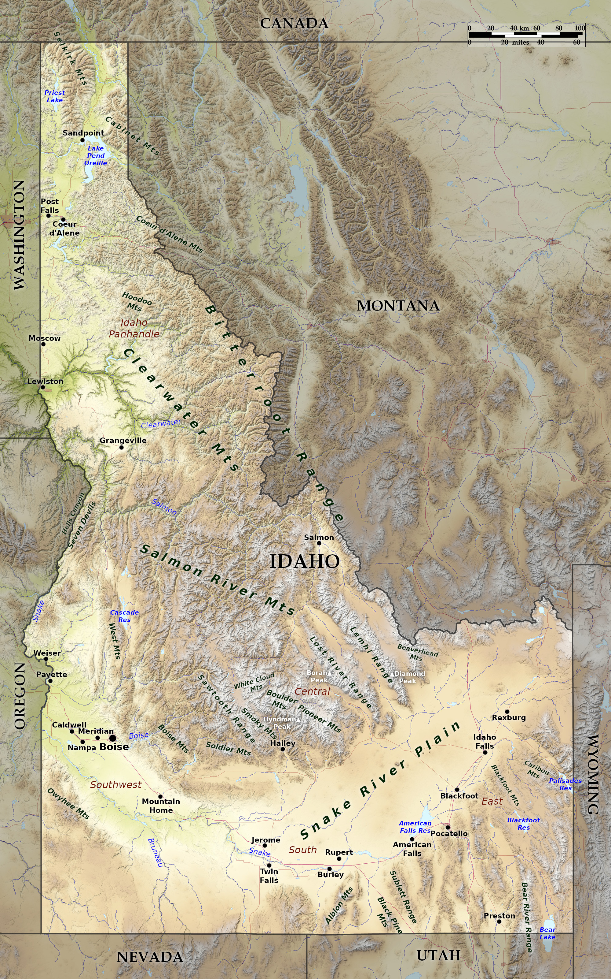 Relief map of Idaho
What is the landscape of Idaho like?
Northern and Central
.jpeg)
Idaho is extremely mountainous. The Bitterroot range, a part of the great Rocky Mountains, forms the northeast border separating Idaho from Montana. The Rocky Mountain region reaches across the north part of the state (the Panhandle), and south into the middle of the state. In the far north the mountains are relatively low, with rounded tops.
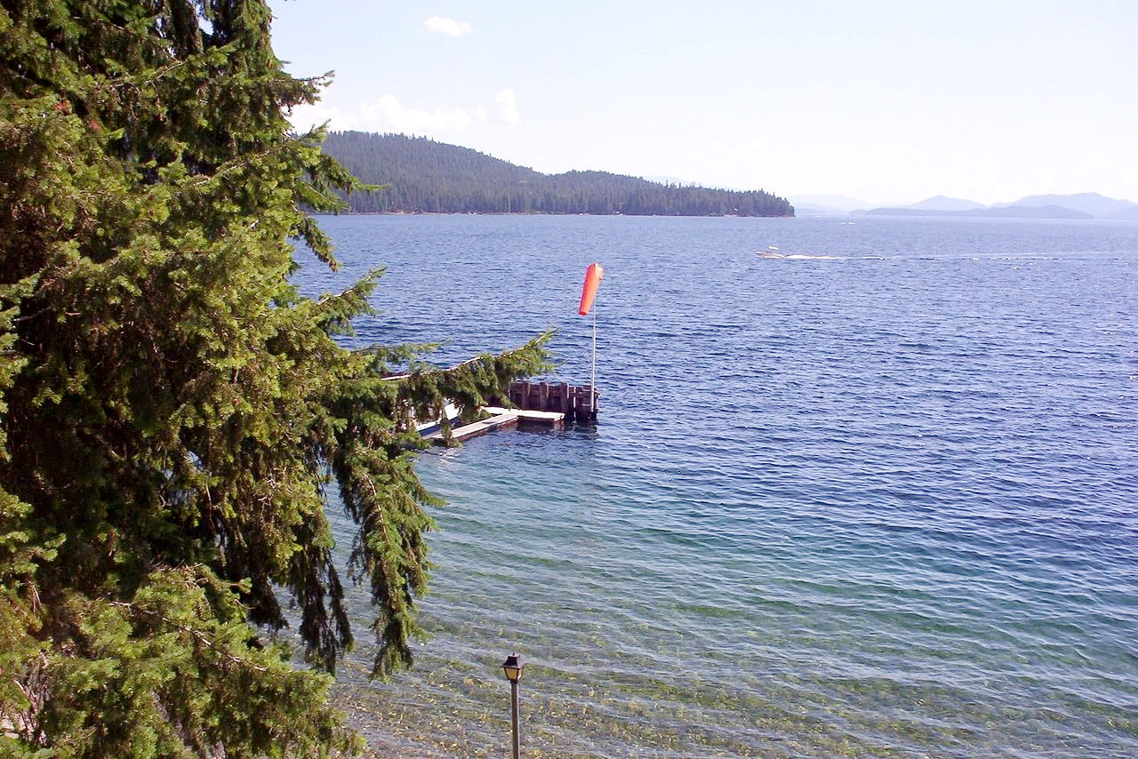
Scattered among the mountains are beautiful glacial lakes. In the north are: Coeur d'Alene Lake, about 30 miles long and from 2 to 4 miles wide; Priest Lake, 20 miles long and about 10 miles wide; and Lake Pend Oreille, 60 miles long and from 3 to 15 miles wide. But there are also prairie regions around Grangeville and Moscow.
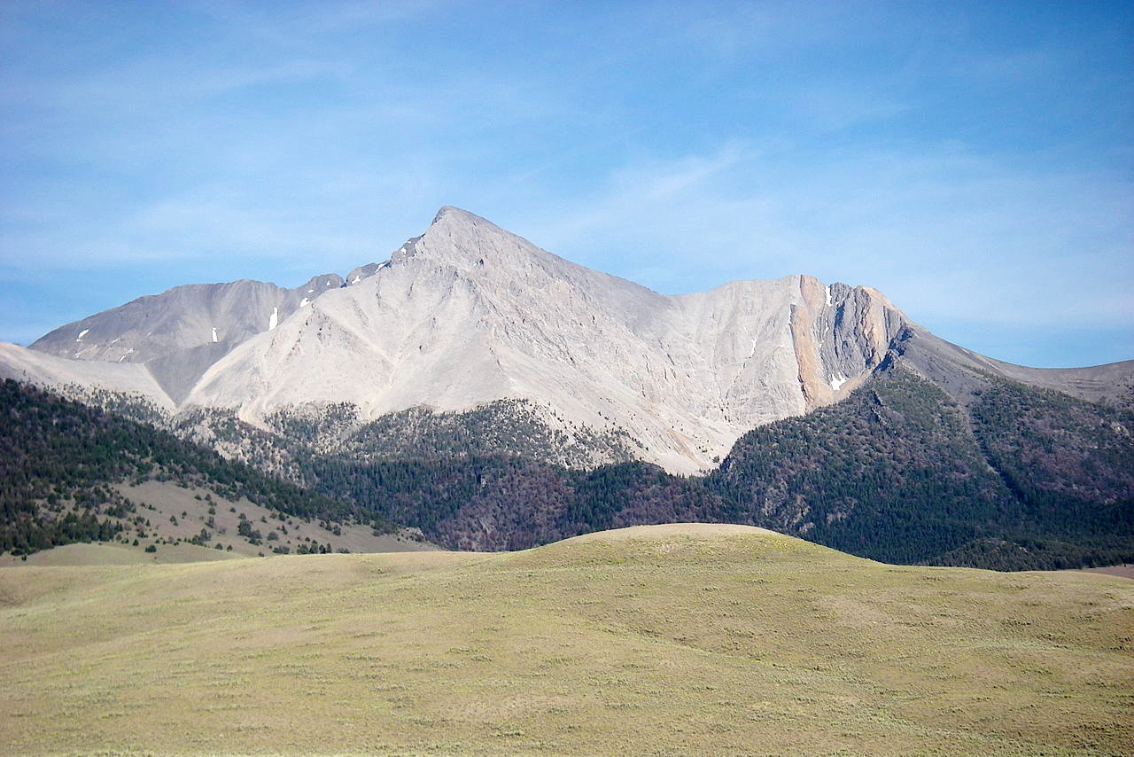
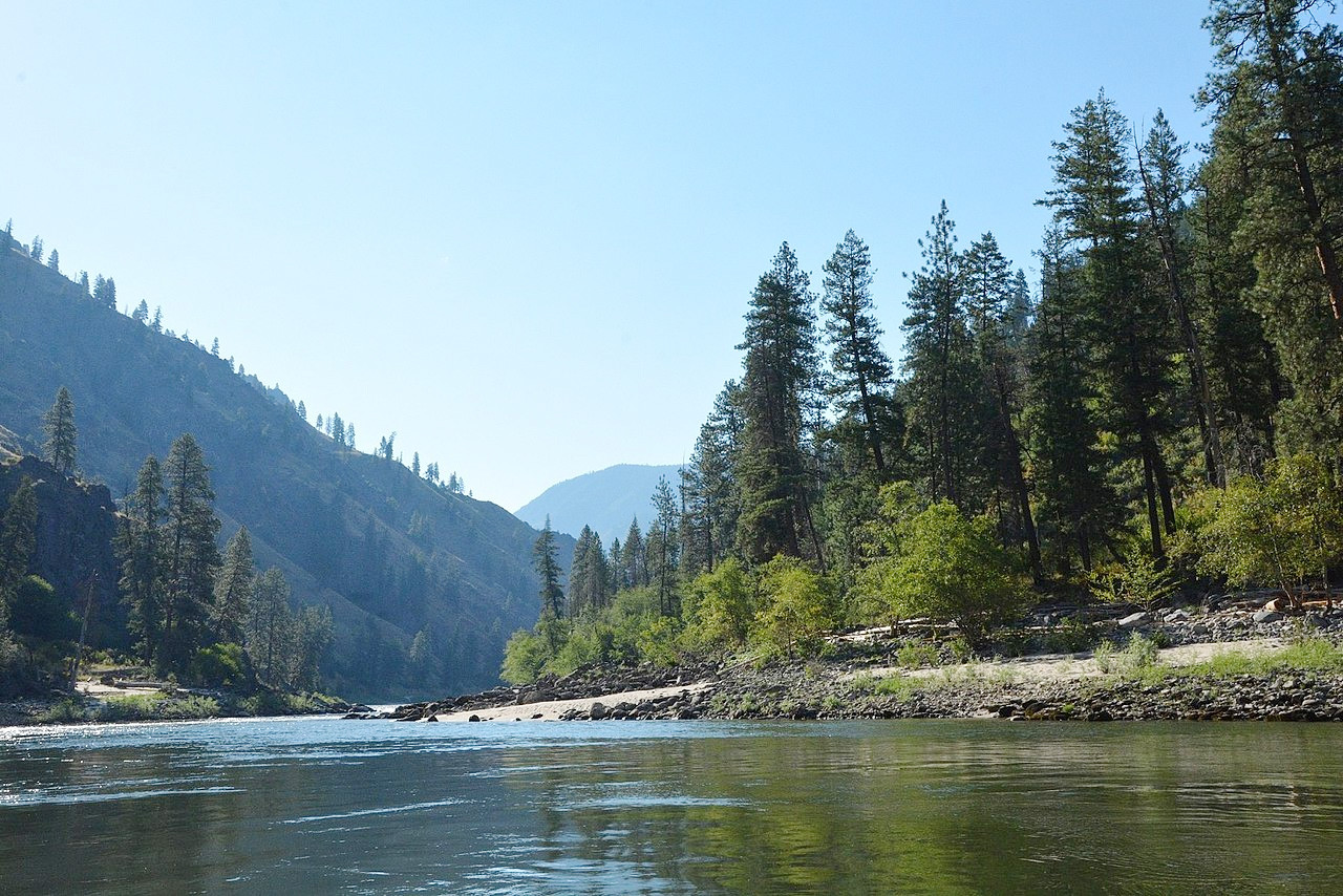
Toward the middle of Idaho the mountains grow very rugged, having Alpine scenery with many sharp peaks and ridges, U-shaped valleys, cirques, lakes and waterfalls. The creeks have dug deep canyons through which they tumble in rapids, falls, cascades, with occasional placid stretches.
Among the most important mountain ranges are the Clearwater (the largest range), Salmon River, Sawtooth, Lost River, and Lemhi mountains. The central peaks carry snow and ice fields the year round. More than 40 peaks rise above 10,000 feet (3,000 m), of which the highest is Mount Borah, at 12,662 feet (3,859 m), in the Lost River Range.
Snake River Plain
.jpeg)
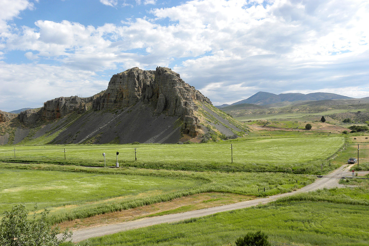
The Snake River Plain extends east-to-west across Idaho from Yellowstone National Park (mostly in Wyoming) to the Boise area. The plains extend follow a curved course around the southern end of the mountains for about 350 miles over a belt 50 to 75 miles wide. It is an ancient volcanic landscape, with great extinct craters, solidified lava flows, canyons, crevices, caves with ice, super-chilled springs. The most prominent among the volcanic domes is Big Southern Butte, which rises steeply 2,380 feet (730 m) above the plain (7,550 feet / 2,300 m above the sea) in Blaine county.
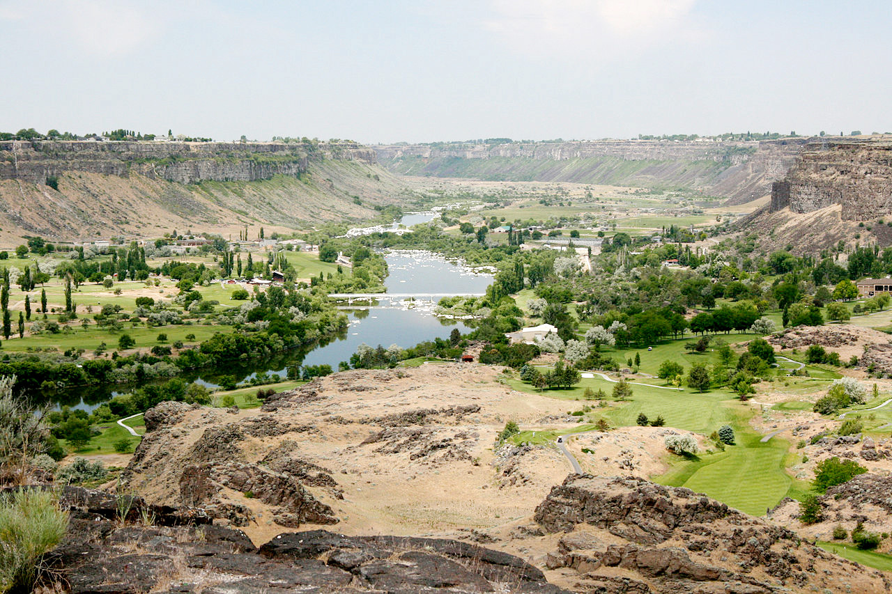
The Snake River—one of the longest rivers in the United States—rises in Yellowstone National Park. It flows southwest and then west for about 800 miles in a canyon across southern Idaho; it turns north and runs as the boundary between Idaho and Oregon, before turning again at Lewiston into Washington State. Almost the entire valley of the Snake River is a canyon, with walls from a few hundred to 6,000 feet (1,800 m) in height.
_on_the_Oregon_National_Historic_Trail_(2007)_(783fe440-73d8-4539-abfd-2b65df691419).jpeg)
The finest parts of Snake River are magnificent; among its waterfalls are the Shoshone Falls and the Salmon Falls. At the Shoshone Falls the river makes a sudden plunge of nearly 200 feet (60 m), and the Falls have been compared with the Niagara. At Hell's Canyon on the border with Oregon, the Snake River cuts the deepest gorge in North America, 7,993 feet (2,436 m) deep.
Southern mountains
A high-mountain area encroaches into the southeastern corner of Idaho. This is a part of the Great Basin region of the United States which drains southwards into Utah (into Great Salt Lake, via Bear River). Bear Lake, in the extreme southeast, lies partly in Utah. The mountains here belonging to the Rocky Mountain region. The rest of Idaho's southern edge consists mostly of low, dry mountains, being a part of the Columbia Plateau region.
What is the nature of Idaho like?
.jpg&oldid=526987358)
.jpg&oldid=485453559)
.jpg&oldid=495971537)
.jpg&oldid=503635347)
.jpg&oldid=488343744)
.jpg&oldid=459117601)
.jpg&oldid=484615312)
.jpg&oldid=488343207)
.jpg&oldid=491847679)
_on_the_Oregon_National_Historic_Trail_(2007)_(783fe440-73d8-4539-abfd-2b65df691419).JPG&oldid=466948007)
With ecosystems ranging from prairie to mountaintop, Idaho has a great variety of plantlife. In the north the western white pine (the state tree) forms great forests; whereas in central and southern parts of the state, ponderosa pine is more dominant. Other common evergreens are Douglas fir, juniper, pinyon pine, spruce, and fir.
In central and southern Idaho there are fertile prairies, called Camas Prairies, by the early travellers, from their blue flowering camas plants. In drier areas, especially in the Snake River Plain, the prairies become sagebrush semi desert intermixed with patches of small trees.
What is the climate of Idaho like?
Idaho experiences four distinct seasons. As a general rule the climate tends to be more moderate in the western part of the State and more extreme—continental—towards the east. The mountains have heavy snowfall in winter; but the plains and valleys have a milder climate, free from great extremes, as the summer heat is moderated by mountain breezes. The mildest region is the Snake river basin between Twin Falls and Lewiston. Average temperatures in Boise range from 32°F (0°C) in January to 77°F (25°C) in July.
Rainfall is low throughout the state: in the south it is very light, but it increases toward the north and east, where the mountain ranges capture the moist winds. Snow accumulates on the ground in winter, but the winters are short and there are long growing seasons in the spring and summer.
| Climate data for Boise, Idaho (1991–2020) | |||||||||||||
|---|---|---|---|---|---|---|---|---|---|---|---|---|---|
| Month | Jan | Feb | Mar | Apr | May | Jun | Jul | Aug | Sep | Oct | Nov | Dec | Year |
| Average high °F (°C) | 38.8 (3.8) | 46.0 (7.8) | 55.5 (13.1) | 62.3 (16.8) | 72.3 (22.4) | 81.4 (27.4) | 92.7 (33.7) | 90.7 (32.6) | 80.0 (26.7) | 64.8 (18.2) | 48.8 (9.3) | 38.8 (3.8) | 64.3 (17.9) |
| Daily mean °F (°C) | 32.2 (0.1) | 37.5 (3.1) | 45.2 (7.3) | 50.9 (10.5) | 59.9 (15.5) | 67.8 (19.9) | 77.3 (25.2) | 75.8 (24.3) | 66.3 (19.1) | 53.2 (11.8) | 40.3 (4.6) | 32.1 (0.1) | 53.2 (11.8) |
| Average low °F (°C) | 25.5 (−3.6) | 29.0 (−1.7) | 34.9 (1.6) | 39.6 (4.2) | 47.5 (8.6) | 54.1 (12.3) | 61.9 (16.6) | 60.8 (16.0) | 52.6 (11.4) | 41.5 (5.3) | 31.7 (−0.2) | 25.4 (−3.7) | 42.0 (5.6) |
| Average precipitation inches (mm) | 1.41 (36) | 1.00 (25) | 1.33 (34) | 1.23 (31) | 1.45 (37) | 0.75 (19) | 0.21 (5.3) | 0.17 (4.3) | 0.43 (11) | 0.81 (21) | 1.18 (30) | 1.54 (39) | 11.51 (292) |
| Average snowfall inches (cm) | 5.3 (13) | 3.3 (8.4) | 1.2 (3.0) | 0.1 (0.25) | 0.0 (0.0) | 0.0 (0.0) | 0.0 (0.0) | 0.0 (0.0) | 0.0 (0.0) | 0.1 (0.25) | 2.0 (5.1) | 5.6 (14) | 17.6 (45) |
| Source: NOAA | |||||||||||||
.jpeg) Birch Creek and Lemhi Mountains
Birch Creek and Lemhi Mountains
.jpg&oldid=501986700)
The official websites
Idaho
The Gem State
| Location: | Northwestern United States, part of the Rocky Mountains |
| Coordinates: | 44° 15′ N, 114° 30′ W |
| Size: | • 770 km N-S; 490 km E-W • 480 miles N-S; 305 miles E-W |
| Terrain: | Extremely mountainous in the north. The Snake River Plain extends east to west across the south. Southern edge has low mountains |
| Climate: | Mountain climate with four distinct seasons. Cold winters; warm summers; low humidity throughout the state. |
| Highest point: | Borah Peak 3,859 m / 12,662 ft |
| Forest: | 41% (2016) (source) |
| Population: | 1,787,065 (2019) |
| Population density: | Very Low (8/km²) |
| Capital: | Boise |
| Languages: | English |
| Human Development Index: | Very High (0.912) |