The Geography of
Illinois
Why visit Illinois?
Illinois is an idyllic place with a lot to offer. The landscape is varied and beautiful, with its gently rolling prairies, sloping hills, broad valleys, and one of the most extensive river systems in the United States. It has Lake Michigan; the Mississippi, Illinois, Ohio, and Rock rivers; the Cahokia Mounds, the largest group of prehistoric earthworks in the USA; and the Lincoln Home National Historic Site.
Map
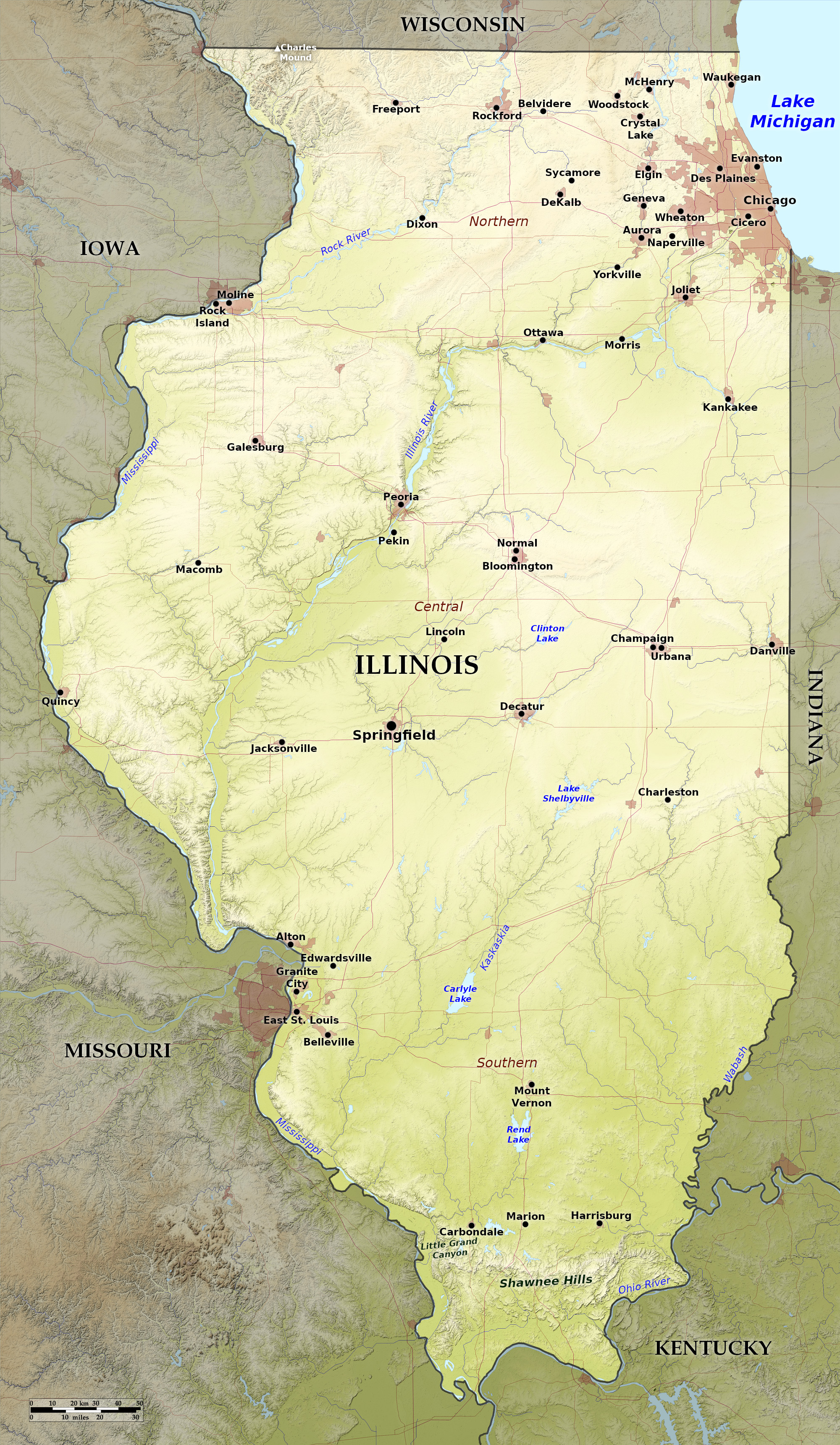
 Relief map of Illinois
What is the landscape of Illinois like?
Great Prairie
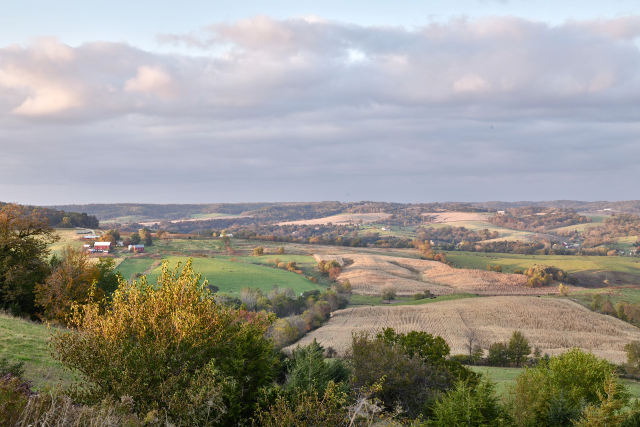
Illinois lies within the Central Plains of the United States. The principal features of the State are the great prairies, from which Illinois derives its nickname, the "Prairie State." Unlike the great plains of the west, however, Illinois has rolling, with sloping hills and broad, shallow valleys. In general Illinois slopes from north-to-south. The highest part of the state is in the northwest, where there are some hills: the highest point being Charles Mound at 1,235 feet (376 m) on the Illinois-Wisconsin border (it is lower though than many of Chicago's skyscrapers).
Except along the rivers, the greater part of the State consists of a vast level or slightly undulating treeless prairie. Much of this land has been reclaimed from swamp by networks of ditches creating thousands of artificial lakes and ponds. This has made Illinois a most fertile prairie and a great agricultural state. These prairies sometimes terminate in well-wooded ridges, especially near the rivers, which does provide some woodland beauty.
There are more than 275 rivers in the state, grouped in two river systems, the majority draining towards the Mississippi River in the west, and the remainder draining to the Wabash and Ohio rivers in the east. The most important river is the Illinois River, which crosses the north central and west portions of the state over a course of nearly 500 miles. At some points, notably at Lake Peoria, it broadens into vast expanses resembling lakes.
There are bluffs along some of the rivers which contrast strikingly with the smooth prairies. The most remarkable of these elevations, on the Mississippi, and are from 100 to 400 feet (30–120 m) high. Fountain Bluff is isolated range of hills, 6 miles in circuit and 300 feet (90 m) high; the top is full of sink holes and natural springs.
Starved Rock and Lover's Leap are eminences on the Illinois River. Starved Rock is a tall mass of limestone and sandstone, 8 miles below Ottawa, rising 156 feet (48 m) above the river. Lover's Leap is a ledge of steep rocks some distance above Starved Rock. Nearly opposite Lover's Leap is Buffalo Rock, 60 feet (18 m) high, steep toward the river, but sloping inland. The Cave-In-Rock on the Ohio River, presents on approach a vast mass of rocks, some resembling castle ruins, and others jutting out in a variety of forms. The cave is famous for once being the home of bands of robbers and river pirates.
Shawnee Hills
The southern part of the state is crossed by another line of hills, from the Ohio River to the Mississippi. This is a spur of the Ozark Mountains known as the Shawnee Hills. This is a hilly range, 6 to 10 miles wide, which rises to the height of about 1,000 feet (300 m). A large portion of the Shawnee Hills lies within the Shawnee National Forest, and the beauty of the hills make the area a prime tourist destination.
What is the nature of Illinois like?
Northern and central Illinois was once typical prairie, but much of the land is now agricultural, but around one-tenth of the oak and hickory forests common to this region still survive. The forest area is greater in the southern counties, and here can be found black oak, sugar maple, box elder, slippery elm, beech, shagbark hickory, white ash, sycamore, black walnut, sweet gum, cottonwood, black willow, and jack pine.
The grasses and flowering plants which once beautified the prairie landscape are still found in places, especially the nature preserves. Characteristic wildflowers are the Chase aster, French's shooting star, lupine, primrose violet, purple trillium, small fringed gentian, and yellow fringed orchid.
What is the climate of Illinois like?
Illinois has a continental climate, with cold, snowy winters and hot, wet summers. The warm winds which sweep up the Mississippi Valley from the Gulf of Mexico can bring about high temperatures, but Arctic winds of the north, which find no mountain range to break their strength, can cause the temperature to plunge. Average winter temperatures, north and south, range from 22°F to 37°F (-6°C to 3°C); average summer temperatures, north and south, range from 74°F to 80°F (23°C to 27°C). The summer heat is usually moderated by the ever present breezes.
Rainfall is well balanced throughout the four seasons of the year, although it is usually lowest in the winter months. Southern Illinois receives the most rainfall, but northern Illinois receives the heaviest winter snows, with up to 38 inches (97 cm) falling in Chicago.
| Climate data for Springfield, Illinois (1991–2020) | |||||||||||||
|---|---|---|---|---|---|---|---|---|---|---|---|---|---|
| Month | Jan | Feb | Mar | Apr | May | Jun | Jul | Aug | Sep | Oct | Nov | Dec | Year |
| Average high °F (°C) | 35.9 (2.2) | 41.1 (5.1) | 53.1 (11.7) | 65.6 (18.7) | 75.7 (24.3) | 84.0 (28.9) | 86.8 (30.4) | 85.4 (29.7) | 80.2 (26.8) | 67.4 (19.7) | 52.7 (11.5) | 40.7 (4.8) | 64.1 (17.8) |
| Daily mean °F (°C) | 27.9 (−2.3) | 32.4 (0.2) | 43.2 (6.2) | 54.4 (12.4) | 65.1 (18.4) | 73.7 (23.2) | 76.5 (24.7) | 74.9 (23.8) | 68.0 (20.0) | 56.0 (13.3) | 43.5 (6.4) | 32.9 (0.5) | 54.0 (12.2) |
| Average low °F (°C) | 19.9 (−6.7) | 23.7 (−4.6) | 33.2 (0.7) | 43.3 (6.3) | 54.4 (12.4) | 63.3 (17.4) | 66.2 (19.0) | 64.3 (17.9) | 55.8 (13.2) | 44.6 (7.0) | 34.2 (1.2) | 25.2 (−3.8) | 44.0 (6.7) |
| Average precipitation inches (mm) | 2.03 (52) | 1.93 (49) | 2.76 (70) | 3.97 (101) | 4.52 (115) | 4.61 (117) | 3.85 (98) | 3.37 (86) | 2.86 (73) | 3.26 (83) | 2.71 (69) | 2.15 (55) | 38.04 (966) |
| Average snowfall inches (cm) | 6.7 (17) | 6.1 (15) | 3.1 (7.9) | 0.3 (0.76) | 0.0 (0.0) | 0.0 (0.0) | 0.0 (0.0) | 0.0 (0.0) | 0.0 (0.0) | 0.1 (0.25) | 1.2 (3.0) | 4.3 (11) | 21.8 (55) |
| Source: NOAA | |||||||||||||
 Prairie scene outside Savanna, Illinois
The official websites
Illinois

The Prairie State
| Location: | Eastern north-central United States |
| Coordinates: | 40° 00′ N, 89° 15′ W |
| Size: | • 630 km N-S; 340 km E-W • 390 miles N-S; 210 miles E-W |
| Terrain: | Part of the Central Plains. Mostly flat. Rolling hills in the northwest and the southern third of the state. |
| Climate: | Continental climate with cool, snowy winters and hot, humid summers |
| Highest point: | Charles Mound 376 m / 1,235 ft |
| Forest: | 14% (2016) (source) |
| Population: | 12,671,821 (2019) |
| Population density: | Low-to-medium (89/km²) |
| Capital: | Springfield |
| Languages: | English (80.8%); Spanish (14.9%); Other (5.1%) |
| Human Development Index: | Very High (0.934) |


