The Climate of
China
.jpg) Yellow Crane Tower, Wuhan
Yellow Crane Tower, Wuhan
.jpg&oldid=624506402)
Climate Map
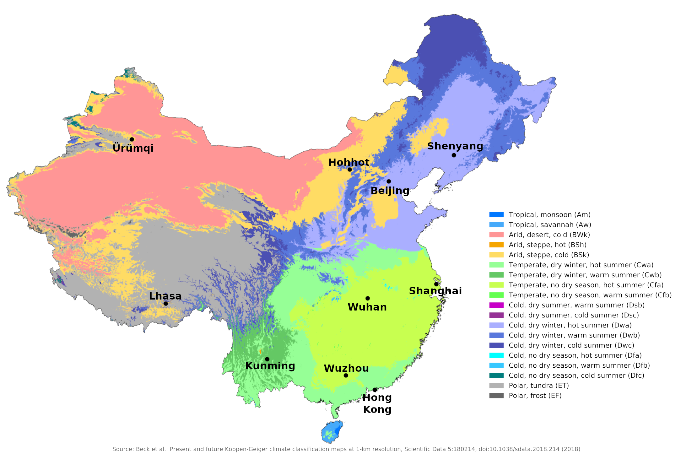 Climate map of China
What is the climate of China like?
The vast territory of China stretches across Central and East Asia. China has a range of climate zones ranging from tropical to cold temperate and from high mountain to desert. China borders Kazakhstan and Kyrgyzstan to the northwest; long land borders with Mongolia and Russia to the north; and to the south it borders with Vietnam, Laos, Myanmar, India, Nepal and Pakistan. Except for Inner Mongolia and Manchuria, these land borders cross some of the most mountainous countries in the world. This helps to make the climate very distinctive in most parts of China.
The climate in an area as large as China is bound to vary widely. The southern parts of Yunnan, Guangxi and Guangdong are in the tropics. The northern zone (where Beijing is located), on the other hand, has a northern European climate with severe winters. The Central Zone (where Shanghai is located) has a generally temperate climate. But across both northern and central China, the influence of the great plateau of Mongolia tends to create uniform conditions unusual in such a large area.
The climate in China and Manchuria is dominated by the great seasonal wind reversal, the Asian monsoon. The prevailing winds during summer—the rainy season—are southeasterly winds, caused by heat and the rising air currents over the sandy deserts of Central Asia, attracting a current from the Pacific Ocean. In winter the opposite takes place and the prevailing winds coming down from the Mongolian plateau are north and north-west and are cold and dry.
The second key influence over China's climate is latitude. While most of the country has warm to hot summers, there are large temperature differences in winter both from north to south and from the western provinces to the coastal regions. Northern China, including Manchuria, experiences extremely cold winters of almost Siberian severity, while Inner Mongolia and the Xinjiang Uyghurs share in this winter chill. A large highland plateau surrounded by some of the world's highest mountains, Tibet has cool summers and very cold winters.
There are, however, important differences in weather and climate, both from north to south and from the lowlands and river valleys of China to the desert and mountainous regions of the outer provinces. Southern and central China have tropical or subtropical climates with no real winter cold, while northern China, Manchuria and the western provinces experience severe winters. Eastern China has abundant summer rains, while the northern and western regions contain much desert and semi-desert.
The country can be divided into the following major climatic regions: northeast China including Manchuria, central China, south China, southwest China, Tiber, Xinjiang Uygur and the western interior, and Inner Mongolia.
Northeastern China, including Manchuria
Shenyang in Manchuria and Beijing are representative of conditions here. This region consists broadly of the large lowland area of the Yellow River (Huang He) Valley, part of Inner Mongolia and all of Manchuria. The winters are very cold with frequent light snowfall and a lot of frost. The strong outflowing winds often raise clouds of dust, which are a troublesome feature of the weather. Both winter and summer temperatures decrease rapidly northward, causing rivers in northern Manchuria to freeze for four to six months. The extreme north of Manchuria has a significantly colder summer than Shenyang or Beijing and snow ranges from 100 to 150 days.
Summers are warm and humid in much of northern China and can be quite uncomfortable. Summer rainfall is sufficient for cultivation almost everywhere, but is rather unreliable; in some years, drought may be a problem. The most unpleasant characteristics of the climate are the summer humidity and the cold, which in winter is exacerbated by wind chill, so warm winter clothing is needed.
| Climate data for Shenyang (1981–2010) | |||||||||||||
|---|---|---|---|---|---|---|---|---|---|---|---|---|---|
| Month | Jan | Feb | Mar | Apr | May | Jun | Jul | Aug | Sep | Oct | Nov | Dec | Year |
| Average high °C (°F) | −4.9 (23.2) | −0.3 (31.5) | 7.0 (44.6) | 16.9 (62.4) | 23.4 (74.1) | 27.5 (81.5) | 29.0 (84.2) | 28.6 (83.5) | 24.0 (75.2) | 16.2 (61.2) | 5.6 (42.1) | −2.2 (28.0) | 14.2 (57.6) |
| Daily mean °C (°F) | −11.2 (11.8) | −6.4 (20.5) | 1.3 (34.3) | 10.6 (51.1) | 17.5 (63.5) | 22.2 (72.0) | 24.6 (76.3) | 23.8 (74.8) | 17.8 (64.0) | 9.9 (49.8) | 0.1 (32.2) | −7.9 (17.8) | 8.5 (47.3) |
| Average low °C (°F) | −16.5 (2.3) | −11.9 (10.6) | −3.9 (25.0) | 4.5 (40.1) | 11.6 (52.9) | 17.1 (62.8) | 20.6 (69.1) | 19.4 (66.9) | 12.3 (54.1) | 4.4 (39.9) | −4.5 (23.9) | −12.7 (9.1) | 3.4 (38.1) |
| Average precipitation mm (inches) | 6.9 (0.27) | 8.6 (0.34) | 20.6 (0.81) | 39.5 (1.56) | 53.1 (2.09) | 92.5 (3.64) | 173.6 (6.83) | 169.2 (6.66) | 64.6 (2.54) | 39.4 (1.55) | 20.3 (0.80) | 10.2 (0.40) | 698.5 (27.49) |
| Source: China Meteorological Administration | |||||||||||||
| Climate data for Beijing (1986–2015) | |||||||||||||
|---|---|---|---|---|---|---|---|---|---|---|---|---|---|
| Month | Jan | Feb | Mar | Apr | May | Jun | Jul | Aug | Sep | Oct | Nov | Dec | Year |
| Average high °C (°F) | 2.1 (35.8) | 5.8 (42.4) | 12.6 (54.7) | 20.7 (69.3) | 26.9 (80.4) | 30.5 (86.9) | 31.5 (88.7) | 30.5 (86.9) | 26.2 (79.2) | 19.4 (66.9) | 10.3 (50.5) | 3.8 (38.8) | 18.4 (65.0) |
| Daily mean °C (°F) | −2.9 (26.8) | 0.4 (32.7) | 7.0 (44.6) | 14.9 (58.8) | 21.0 (69.8) | 25.0 (77.0) | 26.9 (80.4) | 25.8 (78.4) | 20.8 (69.4) | 13.8 (56.8) | 5.1 (41.2) | −0.9 (30.4) | 13.1 (55.5) |
| Average low °C (°F) | −7.1 (19.2) | −4.3 (24.3) | 1.6 (34.9) | 8.9 (48.0) | 14.9 (58.8) | 19.8 (67.6) | 22.7 (72.9) | 21.7 (71.1) | 16.0 (60.8) | 8.8 (47.8) | 0.6 (33.1) | −4.9 (23.2) | 8.2 (46.8) |
| Average precipitation mm (inches) | 2.7 (0.11) | 5.0 (0.20) | 10.2 (0.40) | 23.1 (0.91) | 39.0 (1.54) | 76.7 (3.02) | 168.8 (6.65) | 120.2 (4.73) | 57.4 (2.26) | 24.1 (0.95) | 13.1 (0.52) | 2.4 (0.09) | 542.7 (21.38) |
| Source: China Meteorological Administration | |||||||||||||
Central China
Shanghai on the coast and Wuhan, some 640 km (400 miles) inland in the valley of the Chiang Jiang (the "Yangtze River"), are representative of this region which has warmer summers than northern China and milder winters.
Although the main rainy season is summer, there is some rain throughout the year and the winter weather is more changeable than in northern China. There are periods of wet weather alternating with cold periods of frost and snow; Snow falls on about five to ten days a year. This changeable winter weather is not unlike that experienced in parts of western Europe and the mid-Atlantic states of the United States. It is a sequence of frontal systems and depressions moving west to east along a zone of convergence between cold Siberian air and warm Pacific air.
Summer weather is warm and usually humid due to the inflow of warm, humid air from the Pacific; Heat and humidity are sometimes rather uncomfortable. Coastal regions occasionally receive very heavy rainfall from typhoons or tropical cyclones that strengthen in the South China Sea and move northeast along the coast. The very strong winds associated with these disturbances are most violent in the coastal belt.
Further inland in central China, there is a region in the middle and upper Yangtze (Chiang Jiang) valleys, the Sichuan Basin, where winters are significantly milder and summers tend to receive less rain. This area has a more comfortable climate as snow and frost are less common in winter and the summer humidity is less uncomfortable.
| Climate data for Shanghai (1981–2010) | |||||||||||||
|---|---|---|---|---|---|---|---|---|---|---|---|---|---|
| Month | Jan | Feb | Mar | Apr | May | Jun | Jul | Aug | Sep | Oct | Nov | Dec | Year |
| Average high °C (°F) | 8.1 (46.6) | 10.1 (50.2) | 13.8 (56.8) | 19.5 (67.1) | 24.8 (76.6) | 27.8 (82.0) | 32.2 (90.0) | 31.5 (88.7) | 27.9 (82.2) | 22.9 (73.2) | 17.3 (63.1) | 11.1 (52.0) | 20.6 (69.0) |
| Daily mean °C (°F) | 4.8 (40.6) | 6.6 (43.9) | 10.0 (50.0) | 15.3 (59.5) | 20.7 (69.3) | 24.4 (75.9) | 28.6 (83.5) | 28.3 (82.9) | 24.9 (76.8) | 19.7 (67.5) | 13.7 (56.7) | 7.6 (45.7) | 17.1 (62.7) |
| Average low °C (°F) | 2.1 (35.8) | 3.7 (38.7) | 6.9 (44.4) | 11.9 (53.4) | 17.3 (63.1) | 21.7 (71.1) | 25.8 (78.4) | 25.8 (78.4) | 22.4 (72.3) | 16.8 (62.2) | 10.6 (51.1) | 4.7 (40.5) | 14.1 (57.5) |
| Average precipitation mm (inches) | 74.4 (2.93) | 59.1 (2.33) | 93.8 (3.69) | 74.2 (2.92) | 84.5 (3.33) | 181.8 (7.16) | 145.7 (5.74) | 213.7 (8.41) | 87.1 (3.43) | 55.6 (2.19) | 52.3 (2.06) | 43.9 (1.73) | 1,166.1 (45.91) |
| Source: China Meteorological Administration | |||||||||||||
| Climate data for Wuhan (1981–2010) | |||||||||||||
|---|---|---|---|---|---|---|---|---|---|---|---|---|---|
| Month | Jan | Feb | Mar | Apr | May | Jun | Jul | Aug | Sep | Oct | Nov | Dec | Year |
| Average high °C (°F) | 8.1 (46.6) | 10.7 (51.3) | 15.2 (59.4) | 22.1 (71.8) | 27.1 (80.8) | 30.2 (86.4) | 32.9 (91.2) | 32.5 (90.5) | 28.5 (83.3) | 23.0 (73.4) | 16.8 (62.2) | 10.8 (51.4) | 21.5 (70.7) |
| Daily mean °C (°F) | 4.0 (39.2) | 6.6 (43.9) | 10.9 (51.6) | 17.4 (63.3) | 22.6 (72.7) | 26.2 (79.2) | 29.1 (84.4) | 28.4 (83.1) | 24.1 (75.4) | 18.2 (64.8) | 11.9 (53.4) | 6.2 (43.2) | 17.1 (62.9) |
| Average low °C (°F) | 1.0 (33.8) | 3.5 (38.3) | 7.4 (45.3) | 13.6 (56.5) | 18.9 (66.0) | 22.9 (73.2) | 26.0 (78.8) | 25.3 (77.5) | 20.7 (69.3) | 14.7 (58.5) | 8.4 (47.1) | 2.9 (37.2) | 13.8 (56.8) |
| Average precipitation mm (inches) | 48.7 (1.92) | 65.5 (2.58) | 91.0 (3.58) | 135.7 (5.34) | 166.8 (6.57) | 218.2 (8.59) | 228.1 (8.98) | 117.5 (4.63) | 74.0 (2.91) | 80.9 (3.19) | 60.0 (2.36) | 29.6 (1.17) | 1,316 (51.82) |
| Source: China Meteorological Administration | |||||||||||||
South China
This region is partly in the tropics and is the warmest and wettest part of the country in summer. Rainfall is very heavy between May and September along the coast and plentiful inland. Winters are mild and frost almost unknown. The summer heat and humidity can be quite uncomfortable. Coastal conditions are represented by Hong Kong, those inland by Wuzhou. Typhoons are more frequent and fierce here and can bring very heavy rain and strong winds to the coastal areas for a few days at a time. Typhoons are most common from July to October.
Hong Kong has a monsoon climate similar to southern China. From the beginning of May to the end of September it rains particularly heavily, but it rains in all months. Although there are occasional cold spells lasting a few days in winter, snow and frost are virtually unheard of and the October to March period is generally warm and dry.
Humidity is high during the rather hot, wet summer and the weather is often very muggy and oppressive. Especially between July and September, typhoons moving north from the South China Sea bring heavy rain and very strong winds, which can cause property damage and loss of life. The months of February to April are mostly dry but rather cloudy and the sun only shines for three to four hours a day on average, compared to an average of six to eight hours a day in the months of July to December.
| Climate data for Hong Kong (1991–2020) | |||||||||||||
|---|---|---|---|---|---|---|---|---|---|---|---|---|---|
| Month | Jan | Feb | Mar | Apr | May | Jun | Jul | Aug | Sep | Oct | Nov | Dec | Year |
| Average high °C (°F) | 18.7 (65.7) | 19.4 (66.9) | 21.9 (71.4) | 25.6 (78.1) | 28.8 (83.8) | 30.7 (87.3) | 31.6 (88.9) | 31.3 (88.3) | 30.5 (86.9) | 28.1 (82.6) | 24.5 (76.1) | 20.4 (68.7) | 26.0 (78.8) |
| Daily mean °C (°F) | 16.5 (61.7) | 17.1 (62.8) | 19.5 (67.1) | 23.0 (73.4) | 26.3 (79.3) | 28.3 (82.9) | 28.9 (84.0) | 28.7 (83.7) | 27.9 (82.2) | 25.7 (78.3) | 22.2 (72.0) | 18.2 (64.8) | 23.5 (74.3) |
| Average low °C (°F) | 14.6 (58.3) | 15.3 (59.5) | 17.6 (63.7) | 21.1 (70.0) | 24.5 (76.1) | 26.5 (79.7) | 26.9 (80.4) | 26.7 (80.1) | 26.1 (79.0) | 23.9 (75.0) | 20.3 (68.5) | 16.2 (61.2) | 21.6 (70.9) |
| Average precipitation mm (inches) | 33.2 (1.31) | 38.9 (1.53) | 75.3 (2.96) | 153.0 (6.02) | 290.6 (11.44) | 491.5 (19.35) | 385.8 (15.19) | 453.2 (17.84) | 321.4 (12.65) | 120.3 (4.74) | 39.3 (1.55) | 28.8 (1.13) | 2,431.2 (95.72) |
| Source: Hong Kong Observatory | |||||||||||||
| Climate data for Wuzhou (1981−2010) | |||||||||||||
|---|---|---|---|---|---|---|---|---|---|---|---|---|---|
| Month | Jan | Feb | Mar | Apr | May | Jun | Jul | Aug | Sep | Oct | Nov | Dec | Year |
| Average high °C (°F) | 17.2 (63.0) | 18.0 (64.4) | 21.1 (70.0) | 26.0 (78.8) | 30.1 (86.2) | 32.2 (90.0) | 33.6 (92.5) | 33.7 (92.7) | 32.0 (89.6) | 29.0 (84.2) | 24.3 (75.7) | 19.7 (67.5) | 26.4 (79.6) |
| Daily mean °C (°F) | 12.2 (54.0) | 13.7 (56.7) | 16.7 (62.1) | 21.5 (70.7) | 25.0 (77.0) | 27.2 (81.0) | 28.2 (82.8) | 28.1 (82.6) | 26.6 (79.9) | 23.4 (74.1) | 18.4 (65.1) | 13.9 (57.0) | 21.2 (70.3) |
| Average low °C (°F) | 8.7 (47.7) | 10.6 (51.1) | 13.6 (56.5) | 18.4 (65.1) | 21.6 (70.9) | 23.9 (75.0) | 24.7 (76.5) | 24.5 (76.1) | 22.9 (73.2) | 19.3 (66.7) | 14.2 (57.6) | 9.7 (49.5) | 17.7 (63.8) |
| Average precipitation mm (inches) | 56.5 (2.22) | 75.3 (2.96) | 90.2 (3.55) | 173.5 (6.83) | 249.8 (9.83) | 243.7 (9.59) | 186.8 (7.35) | 156.1 (6.15) | 101.9 (4.01) | 47.3 (1.86) | 41.6 (1.64) | 30.2 (1.19) | 1,452.9 (57.18) |
| Source: China Meteorological Administration | |||||||||||||
Southwestern China
This landlocked region bordering Myanmar, Vietnam and Laos is hilly and mountainous. Summer temperatures are moderated somewhat by the altitude. Winters are generally warm to mild with plenty of sunshine and very little rain. Only occasionally does cold air penetrate here from the north, which occasionally brings frost at higher altitudes. Summers are wet at higher elevations, but precipitation is not excessive in sheltered valleys. This region has the most pleasant weather and climate in China all year round. Kunming in Yunnan Province is representative of this region.
| Climate data for Kunming (1981–2010) | |||||||||||||
|---|---|---|---|---|---|---|---|---|---|---|---|---|---|
| Month | Jan | Feb | Mar | Apr | May | Jun | Jul | Aug | Sep | Oct | Nov | Dec | Year |
| Average high °C (°F) | 15.9 (60.6) | 17.9 (64.2) | 21.1 (70.0) | 24.0 (75.2) | 24.6 (76.3) | 24.6 (76.3) | 24.4 (75.9) | 24.7 (76.5) | 23.1 (73.6) | 20.9 (69.6) | 18.0 (64.4) | 15.5 (59.9) | 21.2 (70.2) |
| Daily mean °C (°F) | 8.9 (48.0) | 10.9 (51.6) | 14.1 (57.4) | 17.3 (63.1) | 19.2 (66.6) | 20.3 (68.5) | 20.2 (68.4) | 19.9 (67.8) | 18.3 (64.9) | 16.0 (60.8) | 12.1 (53.8) | 9.0 (48.2) | 15.5 (59.9) |
| Average low °C (°F) | 3.5 (38.3) | 5.0 (41.0) | 8.0 (46.4) | 11.4 (52.5) | 14.7 (58.5) | 17.0 (62.6) | 17.3 (63.1) | 16.8 (62.2) | 15.2 (59.4) | 12.7 (54.9) | 7.9 (46.2) | 4.2 (39.6) | 11.1 (52.1) |
| Average precipitation mm (inches) | 15.8 (0.62) | 14.6 (0.57) | 17.6 (0.69) | 25.2 (0.99) | 85.5 (3.37) | 170.4 (6.71) | 200.2 (7.88) | 203.9 (8.03) | 113.9 (4.48) | 81.7 (3.22) | 36.7 (1.44) | 13.6 (0.54) | 979.1 (38.54) |
| Source: China Meteorological Administration | |||||||||||||
Tibet
Tibet is a region of plateaus and surrounding mountains in south-central China. Its southern border includes the highest peaks of the Himalayas, such as Everest. Most of the region is above 3,700 meters (12,000 ft), and some extensive areas rise above 4,900 meters (16,000 ft). Winters are severe with frequent light snowfall and hard frosts. Considering the altitude, summer temperatures are surprisingly warm during the day, but there is a very sharp drop in temperature at night. Most precipitation is rain in summer when humid air is drawn into Tibet by the Asian monsoon winds.
In western and northern Tibet, some winter precipitation falls as snow; but the permanent snowline is surprisingly high at about 6,600 meters (20,000 feet). Aside from the low temperatures, the worst feature of the climate is strong winds that increase wind chill. Lhasa shows conditions in the valleys and lower south-eastern part of Tibet. For much of the year the air is very clear and the sunshine is plentiful.
| Climate data for Lhasa (1986−2015) | |||||||||||||
|---|---|---|---|---|---|---|---|---|---|---|---|---|---|
| Month | Jan | Feb | Mar | Apr | May | Jun | Jul | Aug | Sep | Oct | Nov | Dec | Year |
| Average high °C (°F) | 8.4 (47.1) | 10.1 (50.2) | 13.3 (55.9) | 16.3 (61.3) | 20.5 (68.9) | 24.0 (75.2) | 23.3 (73.9) | 22.0 (71.6) | 20.7 (69.3) | 17.5 (63.5) | 12.9 (55.2) | 9.3 (48.7) | 16.5 (61.7) |
| Daily mean °C (°F) | −0.3 (31.5) | 2.3 (36.1) | 5.9 (42.6) | 9.0 (48.2) | 13.1 (55.6) | 16.7 (62.1) | 16.5 (61.7) | 15.4 (59.7) | 13.8 (56.8) | 9.4 (48.9) | 3.8 (38.8) | −0.1 (31.8) | 8.8 (47.8) |
| Average low °C (°F) | −7.4 (18.7) | −4.7 (23.5) | −0.8 (30.6) | 2.7 (36.9) | 6.8 (44.2) | 10.9 (51.6) | 11.4 (52.5) | 10.7 (51.3) | 8.9 (48.0) | 3.1 (37.6) | −3 (27) | −6.8 (19.8) | 2.7 (36.8) |
| Average precipitation mm (inches) | 0.9 (0.04) | 1.8 (0.07) | 2.9 (0.11) | 8.6 (0.34) | 28.4 (1.12) | 75.9 (2.99) | 129.6 (5.10) | 133.5 (5.26) | 66.7 (2.63) | 8.8 (0.35) | 0.9 (0.04) | 0.3 (0.01) | 458.3 (18.06) |
| Source: China Meteorological Administration | |||||||||||||
Xinjiang and the Western Interior
This remote and sparsely populated region of Central Asia is almost entirely desert. It has a continental climate with cold winters and hot summers. The very sparse rainfall is well distributed throughout the year, with a winter maximum in places; This is brought about by weak depressions moving in from the west. Humidity is low all year round; The main dangers are very low temperatures accompanied by strong winds in winter and occasionally very high temperatures in summer. The climate varies locally according to altitude; There are some high mountains on the borders of Kyrgyzstan and Tibet, but extensive areas of the interior lowlands. Ürümqi shows the conditions in Xinjiang at a medium level.
| Climate data for Ürümqi (1981–2010) | |||||||||||||
|---|---|---|---|---|---|---|---|---|---|---|---|---|---|
| Month | Jan | Feb | Mar | Apr | May | Jun | Jul | Aug | Sep | Oct | Nov | Dec | Year |
| Average high °C (°F) | −7.4 (18.7) | −4.7 (23.5) | 2.7 (36.9) | 16.1 (61.0) | 23.1 (73.6) | 27.6 (81.7) | 30.1 (86.2) | 29.0 (84.2) | 23.1 (73.6) | 13.2 (55.8) | 2.0 (35.6) | −4.4 (24.1) | 12.5 (54.6) |
| Daily mean °C (°F) | −12.6 (9.3) | −9.8 (14.4) | −1.7 (28.9) | 10.0 (50.0) | 16.7 (62.1) | 21.5 (70.7) | 23.7 (74.7) | 22.4 (72.3) | 16.7 (62.1) | 7.7 (45.9) | −2.5 (27.5) | −9.3 (15.3) | 6.9 (44.4) |
| Average low °C (°F) | −16.6 (2.1) | −13.7 (7.3) | −5.4 (22.3) | 4.8 (40.6) | 11.2 (52.2) | 16.1 (61.0) | 18.2 (64.8) | 16.7 (62.1) | 11.2 (52.2) | 3.1 (37.6) | −5.9 (21.4) | −12.9 (8.8) | 2.2 (36.0) |
| Average precipitation mm (inches) | 10.4 (0.41) | 10.0 (0.39) | 18.5 (0.73) | 32.3 (1.27) | 38.9 (1.53) | 36.2 (1.43) | 30.4 (1.20) | 23.3 (0.92) | 26.2 (1.03) | 26.3 (1.04) | 19.1 (0.75) | 14.6 (0.57) | 286.2 (11.27) |
| Source: China Meteorological Administration | |||||||||||||
Inner Mongolia
North and east of Xinjiang Uygur, this is a region of mountain ranges and extensive semi-desert lowlands. It borders Central Siberia and Mongolia. It has an extreme continental climate with very cold winters and warm summers. The rainfall is low. Summers are slightly cooler than Xinjiang, and winters are cold and similar to those in Manchuria and northern China. The ground is covered with snow 100 to 150 days a year. See Hohhot for conditions in this area.
High winds in winter and spring often kick up large clouds of dust that are blown eastward into northern China. This is one of the more unpleasant characteristics of the climate. The severe winters make warm clothing very necessary and wind chill can increase the feeling of cold. Sunshine duration varies from five to six hours a day in winter to around nine hours in summer.
| Climate data for Hohhot (1981–2010) | |||||||||||||
|---|---|---|---|---|---|---|---|---|---|---|---|---|---|
| Month | Jan | Feb | Mar | Apr | May | Jun | Jul | Aug | Sep | Oct | Nov | Dec | Year |
| Average high °C (°F) | −4.9 (23.2) | 0.4 (32.7) | 7.5 (45.5) | 16.7 (62.1) | 23.4 (74.1) | 27.7 (81.9) | 29.1 (84.4) | 26.7 (80.1) | 21.9 (71.4) | 14.5 (58.1) | 4.5 (40.1) | −3.2 (26.2) | 13.7 (56.7) |
| Daily mean °C (°F) | −11.0 (12.2) | −6.1 (21.0) | 0.9 (33.6) | 9.6 (49.3) | 16.6 (61.9) | 21.3 (70.3) | 23.3 (73.9) | 21.0 (69.8) | 15.4 (59.7) | 7.6 (45.7) | −1.7 (28.9) | −9.0 (15.8) | 7.3 (45.2) |
| Average low °C (°F) | −15.8 (3.6) | −11.4 (11.5) | −4.9 (23.2) | 2.5 (36.5) | 9.2 (48.6) | 14.5 (58.1) | 17.3 (63.1) | 15.4 (59.7) | 9.3 (48.7) | 1.8 (35.2) | −6.4 (20.5) | −13.4 (7.9) | 1.5 (34.7) |
| Average precipitation mm (inches) | 2.1 (0.08) | 4.3 (0.17) | 10.6 (0.42) | 14.4 (0.57) | 32.4 (1.28) | 48.9 (1.93) | 101.6 (4.00) | 101.8 (4.01) | 52.0 (2.05) | 20.6 (0.81) | 4.4 (0.17) | 3.3 (0.13) | 396.4 (15.62) |
| Source: China Meteorological Administration | |||||||||||||
References
- E. A. Pearce, Charles Gordon Smith, (1990) The Hutchinson World Weather Guide, John Murray Press. ISBN 1859863426
- Timothy L. Gall, (ed.), (2003), Worldmark Encyclopedia of the Nations, Eleventh Edition, Thomson Gale
- Hugh Chisholm, (ed.), (1911), Encyclopædia Britannica, Eleventh edition, Cambridge University Press
The Climate of
China
In summary:
China enjoys a mainly temperate climate, although with many extremes in climate. Minimum winter temperatures range from –27°C (–17°F) in northern Manchuria to –1°C (30°F) in the North China Plain and southern Manchuria, 4°C (39°F) along the middle and lower valleys of the Yangtze, and 16°C (61°F) farther south. Although summer temperatures are more nearly uniform in southern and central China, with a July mean of about 27°C (81°F), northern China has a shorter hot period and the nights are much cooler.
Most of the country’s rainfall occurs during the summer months. Rainfall is heaviest in the southeast, averaging 2,000 millimeters (80 inches) per year. In the northeastern region near Beijing, annual rainfall averages about 600 millimeters (25 inches). In the far northwest, the annual rainfall averages 100 millimeters (4 inches), although some desert regions may go a year or longer with no precipitation. Along the southern coast, severe storms are common, with destructive typhoons occasionally occurring.